

The USGS Processes Impacting Seafloor Change and Ecosystem Services (PISCES) project team meeting at the St. Petersburg Coastal and Marine Science Center in May 2022 to coordinate Structure-from-motion (SfM) Quantitative Underwater Imaging Device with 5 cameras (SQUID-5) and diver-based SfM data acquisition and processing for field work.
Cross-center team testing seafloor structure-from-motion technology in Tampa Bay
By Coastal and Marine Hazards and Resources Program
May 18, 2022
Scientists, engineers, and staff from the Pacific Coastal and Marine Science Center (PCMSC) are at the St. Petersburg Coastal and Marine Science Center this week assisting SPCMSC scientists with testing and preparing the SQUID-5, or Structure-from-motion (SfM) Quantitative Underwater Imaging Device with 5 cameras, for summer field work to collect high resolution, 3D seafloor elevation data.
USGS PISCES (Processes Impacting Seafloor Change and Ecosystem Services) Project Activities
Sources/Usage: Public Domain. View Media Details
PCMSC staff Jonathan Warrick and Gerry Hatcher are visiting St. Petersburg this week working alongside SPCMSC staff Dave Zawada, Selena Johnson, Christine Kranenburg, Mitch Lemon, and Andy Farmer to test and prep SQUID-5 prior to data collection at Looe Key Reef in the lower Florida Keys National Marine Sanctuary planned for July 2022. So far, the team has upgraded components in SQUID-5, tested the cameras with a new calibration target, and conducted field deployments in Tampa Bay. They also trained SPCMSC staff on preparation and operation of SQUID-5. Lastly, the team had an ad-hoc mini-workshop to refine data processing techniques, coordinate SQUID-5 and diver-based SfM acquisition plans to optimize data collection for the July field work, and begin developing co-registration methods and other data analysis techniques.
To produce accurate models of underwater habitats, the USGS created the SQUID-5 or Structure-from-motion (SfM) Quantitative Underwater Imaging Device with 5 cameras. SQUID-5 is towed behind a boat to capture overlapping high-resolution images of the seafloor with accurate GPS locations which are converted into high-resolution, 3-dimensional models of seafloor structures. The team uses the models to predict which areas of the coastline are at risk from the combined hazards of seafloor erosion and sea-level rise. With protective reefs eroding away due to ocean acidification and coral diseases, along with sea levels rising at the same time, more coastal communities are at greater risk of flooding, especially when extreme storms threaten the coast. These data are also translated to stakeholder tools and shared with partners such as the National Oceanic and Atmospheric Administration (NOAA) to inform decisions on where coral reef restoration efforts may be most effective to both increase ecosystem coverage and mitigate the effects of coastal hazards.

Sources/Usage: Public Domain. View Media Details
Related Content
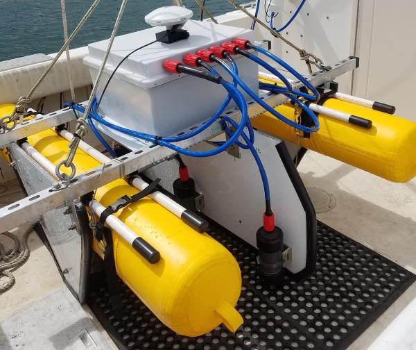
SQUID-5 camera system
The SQUID-5 is a S tructure-from-Motion Q uantitative U nderwater I maging D evice with 5 cameras.

SQUID-5 deployment in Tampa Bay
The SQUID-5, or Structure-from-motion (SfM) Quantitative Underwater Imaging Device with 5 cameras, being deployed by Mitch Lemon (SPCMSC, on the left) and Gerry Hatcher (PCMSC, on the right) in Tampa Bay for testing.
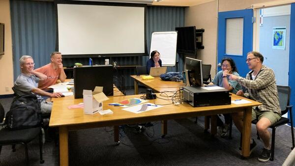
Seafloor Structure-from-Motion (SfM) ad-hoc workshop in St. Petersburg, Florida
The USGS Processes Impacting Seafloor Change and Ecosystem Services (PISCES) project team meeting at the St. Petersburg Coastal and Marine Science Center in May 2022 to coordinate Structure-from-motion (SfM) Quantitative Underwater Imaging Device with 5 cameras (SQUID-5) and diver-based SfM data acquisition and processing for field work.

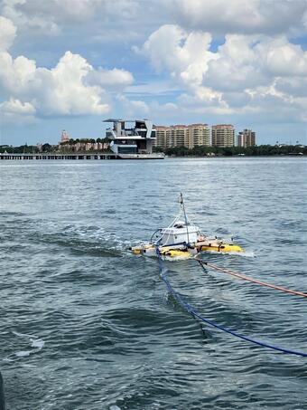
SQUID-5 test near the St. Pete Pier
The SQUID-5, or Structure-from-motion (SfM) Quantitative Underwater Imaging Device with 5 cameras test in Tampa Bay.
The SQUID-5, or Structure-from-motion (SfM) Quantitative Underwater Imaging Device with 5 cameras test in Tampa Bay.

SQUID-5 being prepped for a test run
The SQUID-5, or Structure-from-motion (SfM) Quantitative Underwater Imaging Device with 5 cameras, shown being staged for a test run at the St. Petersburg Coastal and Marine Science Center. In the background, Andy Farmer (SPCMSC) and Gerry Hatcher (PCMSC) prep the R/V Sallenger, the vessel being used to tow the device.
The SQUID-5, or Structure-from-motion (SfM) Quantitative Underwater Imaging Device with 5 cameras, shown being staged for a test run at the St. Petersburg Coastal and Marine Science Center. In the background, Andy Farmer (SPCMSC) and Gerry Hatcher (PCMSC) prep the R/V Sallenger, the vessel being used to tow the device.

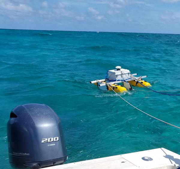
Gerry Hatcher controls SQUID-5
Gerry Hatcher controls SQUID-5 image acquisition over Looe Key Sanctuary Preservation Area (SPA).
Gerry Hatcher controls SQUID-5 image acquisition over Looe Key Sanctuary Preservation Area (SPA).

SQUID-5 Towed Surface Vehicle
Diagram of the SQUID-5 towed surface vehicle and the waterproof camera housings with labeled components. The camera mounting mechanism aligns the camera axially with the dome and allows the camera to be adjusted fore and aft to accommodate various lens types and enable alignment with the glass port radius of curvature for minimal distortion.
Diagram of the SQUID-5 towed surface vehicle and the waterproof camera housings with labeled components. The camera mounting mechanism aligns the camera axially with the dome and allows the camera to be adjusted fore and aft to accommodate various lens types and enable alignment with the glass port radius of curvature for minimal distortion.
SQUID-5 - Structure-from-Motion Quantitative Underwater Imaging Device
The SQUID-5, or a Structure-from-Motion (SfM) Quantitative Underwater Imaging Device with 5 cameras is a towed surface vehicle with an onboard Global Navigation Satellite System (GNSS) and 5 downward-looking cameras with overlapping views of the seafloor.
The SQUID-5, or a Structure-from-Motion (SfM) Quantitative Underwater Imaging Device with 5 cameras is a towed surface vehicle with an onboard Global Navigation Satellite System (GNSS) and 5 downward-looking cameras with overlapping views of the seafloor.
Related Content
SQUID-5 camera system
The SQUID-5 is a S tructure-from-Motion Q uantitative U nderwater I maging D evice with 5 cameras.
SQUID-5 deployment in Tampa Bay
The SQUID-5, or Structure-from-motion (SfM) Quantitative Underwater Imaging Device with 5 cameras, being deployed by Mitch Lemon (SPCMSC, on the left) and Gerry Hatcher (PCMSC, on the right) in Tampa Bay for testing.
Seafloor Structure-from-Motion (SfM) ad-hoc workshop in St. Petersburg, Florida
The USGS Processes Impacting Seafloor Change and Ecosystem Services (PISCES) project team meeting at the St. Petersburg Coastal and Marine Science Center in May 2022 to coordinate Structure-from-motion (SfM) Quantitative Underwater Imaging Device with 5 cameras (SQUID-5) and diver-based SfM data acquisition and processing for field work.
The USGS Processes Impacting Seafloor Change and Ecosystem Services (PISCES) project team meeting at the St. Petersburg Coastal and Marine Science Center in May 2022 to coordinate Structure-from-motion (SfM) Quantitative Underwater Imaging Device with 5 cameras (SQUID-5) and diver-based SfM data acquisition and processing for field work.
SQUID-5 test near the St. Pete Pier
The SQUID-5, or Structure-from-motion (SfM) Quantitative Underwater Imaging Device with 5 cameras test in Tampa Bay.
The SQUID-5, or Structure-from-motion (SfM) Quantitative Underwater Imaging Device with 5 cameras test in Tampa Bay.
SQUID-5 being prepped for a test run
The SQUID-5, or Structure-from-motion (SfM) Quantitative Underwater Imaging Device with 5 cameras, shown being staged for a test run at the St. Petersburg Coastal and Marine Science Center. In the background, Andy Farmer (SPCMSC) and Gerry Hatcher (PCMSC) prep the R/V Sallenger, the vessel being used to tow the device.
The SQUID-5, or Structure-from-motion (SfM) Quantitative Underwater Imaging Device with 5 cameras, shown being staged for a test run at the St. Petersburg Coastal and Marine Science Center. In the background, Andy Farmer (SPCMSC) and Gerry Hatcher (PCMSC) prep the R/V Sallenger, the vessel being used to tow the device.
Gerry Hatcher controls SQUID-5
Gerry Hatcher controls SQUID-5 image acquisition over Looe Key Sanctuary Preservation Area (SPA).
Gerry Hatcher controls SQUID-5 image acquisition over Looe Key Sanctuary Preservation Area (SPA).
SQUID-5 Towed Surface Vehicle
Diagram of the SQUID-5 towed surface vehicle and the waterproof camera housings with labeled components. The camera mounting mechanism aligns the camera axially with the dome and allows the camera to be adjusted fore and aft to accommodate various lens types and enable alignment with the glass port radius of curvature for minimal distortion.
Diagram of the SQUID-5 towed surface vehicle and the waterproof camera housings with labeled components. The camera mounting mechanism aligns the camera axially with the dome and allows the camera to be adjusted fore and aft to accommodate various lens types and enable alignment with the glass port radius of curvature for minimal distortion.
SQUID-5 - Structure-from-Motion Quantitative Underwater Imaging Device
The SQUID-5, or a Structure-from-Motion (SfM) Quantitative Underwater Imaging Device with 5 cameras is a towed surface vehicle with an onboard Global Navigation Satellite System (GNSS) and 5 downward-looking cameras with overlapping views of the seafloor.
The SQUID-5, or a Structure-from-Motion (SfM) Quantitative Underwater Imaging Device with 5 cameras is a towed surface vehicle with an onboard Global Navigation Satellite System (GNSS) and 5 downward-looking cameras with overlapping views of the seafloor.
SQUID-5 - Structure-from-Motion Quantitative Underwater Imaging Device
The SQUID-5, or a Structure-from-Motion (SfM) Quantitative Underwater Imaging Device with 5 cameras is a towed surface vehicle with an onboard Global Navigation Satellite System (GNSS) and 5 downward-looking cameras with overlapping views of the seafloor.
The SQUID-5, or a Structure-from-Motion (SfM) Quantitative Underwater Imaging Device with 5 cameras is a towed surface vehicle with an onboard Global Navigation Satellite System (GNSS) and 5 downward-looking cameras with overlapping views of the seafloor.
Get Our News
These items are in the RSS feed format (Really Simple Syndication) based on categories such as topics, locations, and more. You can install and RSS reader browser extension, software, or use a third-party service to receive immediate news updates depending on the feed that you have added. If you click the feed links below, they may look strange because they are simply XML code. An RSS reader can easily read this code and push out a notification to you when something new is posted to our site.