U.S. flag

An official website of the United States government

Earthquake Hazards Program

The USGS monitors and reports on earthquakes, assesses earthquake impacts and hazards, and conducts targeted research on the causes and effects of earthquakes. We undertake these activities as part of the larger National Earthquake Hazards Reduction Program (NEHRP), a four-agency partnership established by Congress.

News

(Some) Assembly Required: How to sign your organization up for the Great ShakeOut

(Some) Assembly Required: How to sign your organization up for the Great ShakeOut

USGS seeking Loma Prieta felt reports from 35-year-old earthquake

USGS seeking Loma Prieta felt reports from 35-year-old earthquake

Loma Prieta Earthquake 35th Anniversary Compilation

Loma Prieta Earthquake 35th Anniversary Compilation

Publications

U.S. Geological Survey Earthquake Hazards Program decadal science strategy, 2024–33

Executive Summary Earthquakes represent one of our Nation’s most significant and costly natural hazards, with estimated annual loses from earthquakes close to $15 billion in 2023. Over the past two centuries, 37 U.S. States have experienced an earthquake exceeding a magnitude of 5, and 50 percent of States have a significant potential for future damaging shaking; these statistics speak to the need
Authors
Gavin P. Hayes, Annemarie S. Baltay Sundstrom, William D. Barnhart, Michael L. Blanpied, Lindsay A. Davis, Paul S. Earle, Ned Field, Jill M. Franks, Douglas D. Given, Ryan D. Gold, Christine A Goulet, Michelle M. Guy, Jeanne L. Hardebeck, Nico Luco, Frederick Pollitz, Adam T. Ringler, Katherine M. Scharer, Steven Sobieszczyk, Valerie I. Thomas, Cecily J. Wolfe

Shallow lake, strong shake: Record of seismically triggered lacustrine sedimentation from the 1959 M7.3 Hebgen Lake earthquake within Henrys Lake, Idaho

We investigate a shallow lake basin for evidence of a large historic intraplate earthquake in western North America. Henrys Lake, Idaho is an atypical candidate for a lacustrine paleoseismic study given its shallow depth (~7 m) and low relief (≤2° slopes). Here, we test the earthquake-recording capacity of this basin type by showing sedimentological evidence of the 1959 M7.3 Hebgen Lake earthquake
Authors
Sylvia R. Nicovich, Christopher DuRoss, Jessica Ann Thompson Jobe, Jessica R. Rodysill, Richard W. Briggs, Alexandra Elise Hatem, Madeleine Mai-Lynh Tan, Yann Gavillot, Noah Silas Lindberg, Laura E. Strickland, Jason Scott Padgett

Reduced injection rates and shallower depths mitigated induced seismicity in Oklahoma

The proximity of wastewater disposal to the Precambrian basement is a critical factor influencing induced earthquake rates in the Central United States, but the impact of reducing injection depths has not been widely demonstrated. Beginning in 2015, state regulatory efforts in Oklahoma and Kansas mandated that wells injecting into the lower Arbuckle Group, a basal sedimentary unit, be backfilled w
Authors
Robert J. Skoumal, Andrew J. Barbour, Justin L. Rubenstein, Margaret Elizabeth Glasgow

Science

M 6.9 October 17, 1989 Loma Prieta Earthquake

The 1989 Loma Prieta earthquake ended decades of tranquility in the San Francisco Bay region. It was a wakeup call to prepare for the potentially even more devastating shocks that are inevitable in the future. Since 1989, the work of the U.S. Geological Survey and other organizations has improved understanding of the seismic threat in the Bay region, promoted awareness of earthquake hazards, and...
link

M 6.9 October 17, 1989 Loma Prieta Earthquake

The 1989 Loma Prieta earthquake ended decades of tranquility in the San Francisco Bay region. It was a wakeup call to prepare for the potentially even more devastating shocks that are inevitable in the future. Since 1989, the work of the U.S. Geological Survey and other organizations has improved understanding of the seismic threat in the Bay region, promoted awareness of earthquake hazards, and...
Learn More

Earthquake Response and Investigations

Post-earthquake scientific and engineering investigations are undertaken by the USGS and its partners to capture critical information to understand the causes and impacts of the event, lessons from which can substantially improve the Nation’s resilience after future earthquakes.
link

Earthquake Response and Investigations

Post-earthquake scientific and engineering investigations are undertaken by the USGS and its partners to capture critical information to understand the causes and impacts of the event, lessons from which can substantially improve the Nation’s resilience after future earthquakes.
Learn More

Alaska Earthquake and Tsunami Hazards

Alaska has more large earthquakes than the rest of the United States combined. More than three-quarters of the state’s population live in an area that can experience a magnitude 7 earthquake. Our research provides objective science that helps stakeholders prepare for and mitigate the effects of future earthquakes and tsunamis, which bolsters the economic health and well-being of Alaska and the...
link

Alaska Earthquake and Tsunami Hazards

Alaska has more large earthquakes than the rest of the United States combined. More than three-quarters of the state’s population live in an area that can experience a magnitude 7 earthquake. Our research provides objective science that helps stakeholders prepare for and mitigate the effects of future earthquakes and tsunamis, which bolsters the economic health and well-being of Alaska and the...
Learn More

Multimedia

A map of the December 5th, 2024 Earthquake overlaid with decorative images and text Explained: The December 5th, 2024 Earthquake (AD)
Explained: The December 5th, 2024 Earthquake (AD)
An image of the map of the December 5th, 2024 earthquake near Mendocino. The image is overlaid with text and an illustration Explained: The December 5th, 2024 Earthquake
Explained: The December 5th, 2024 Earthquake
4 photos of seismic instruments in a barren room
Seismographs at the Albuquerque Seismological Laboratory
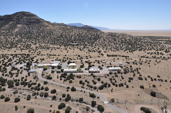
aerial view of desert with a group of buildings and mountains in the background
Aerial View of the Albuquerque Seismological Laboratory
globe with red and green dots
Global Seismographic Network (GSN) Stations
shakeout manual cover page
Cover of fictional Great ShakeOut instruction manual.
shakeout manual page 5
Page 6 of fictional Great ShakeOut instruction manual
shakeout manual page 8
Page 8 of fictional Great ShakeOut instruction manual
shakeout manual page 3
Page 3 of fictional Great ShakeOut instruction manual
Was this page helpful?