
Providing critical weather data for public safety
Governmental and private industry partners rely on USGS science from the Ecosystems Land Change Science Program to deliver critical winter and fire weather forecasting, as well as inform safety and search and rescue operations.
There are thousands of weather stations across the United States. Each of these stations costs thousands of dollars to install and maintain but plays a critically important role in measuring local conditions and relaying that information to the National Weather Service (NWS). NWS then uses that information to develop weather forecasts and send out emergency alerts when needed to protect people and property across the country. Forecasts and warning alerts that are essential to first responders, emergency management, the aviation community, and public at large.
NWS relies on support from partners to help keep all of the weather stations up and running and to install new sensors in difficult to reach areas, like high elevation mountainous zones. This is where USGS comes in.
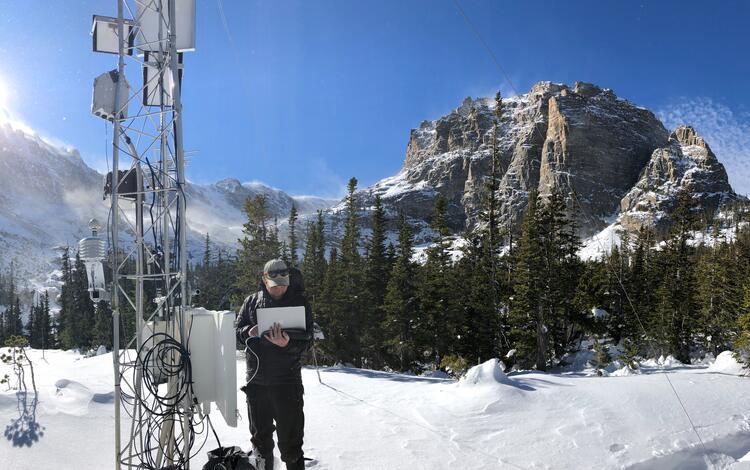
The USGS Snow and Avalanche Research Project is studying changing mountain snow and ice conditions, how those contribute to avalanche activity, and what the impacts are to surrounding infrastructure, communities, and ecosystems in the Rocky Mountains and southeast Alaska.

This research necessitates installing and maintaining high elevation weather stations where weather is not monitored by anyone else in Rocky Mountain and Glacier National Parks, the surrounding regions, and in Alaska. In addition to these data being essential to the snowpack monitoring and avalanche frequency and forecasting work USGS performs, these weather stations are an incredibly important value-add to many partners who use the data daily to protect people, infrastructure, and commerce.
As previously mentioned, the National Weather Service uses the USGS high-elevation weather station data for daily forecasts ranging from winter weather to fire weather forecasting. The USGS produce specific forecasts to help inform the National Park Service of safety threats, like snow avalanches and sudden weather changes, to important visitor areas and transportation corridors. For example, the weather stations in Glacier National Park have been used by NWS to provide point forecasts and send out visitor warnings of heavy summer rain events that could cause dangerous debris flows along the popular Going-to-the-Sun Road that would threaten the safety of thousands of visitors each day. The stations are also used for fire weather and daily woodland fire operations when necessary. Additionally, weather station data from USGS and NWS informs NPS and U.S. Forest Service search and rescue operations.


But it’s not just other federal partners that USGS supports. USGS has long-standing partnerships with State and private sector partners who use weather station data and avalanche frequency data to inform operations on lands they manage and traverse. The weather station data in and around Rocky Mountain National Park and in Colorado, and the snow models that are developed by the USGS scientists, are used by the Bureau of Reclamation and Northern Colorado Water Conservancy District in real time to inform their reservoir and water management operations.
The Montana weather stations are located along an important transportation corridor along the U.S. Highway 2 and BNSF Railway corridor. These stations are used by industry, NPS, and private entities like the Burlington Northern Santa Fe (BNSF) Railway for avalanche forecasting and summer railway operations. BNSF have stated that these weather stations are critical to their daily operations. These stations' provisional data are available to the general public for the timely delivery of important weather data for their own use via. And the Alaska and Montana weather stations provide key information to private industry partners who are interested in recreation and tourism opportunities. For example, aviation companies utilize the live data from high-elevation weather stations to inform their operations and improve safety-related decision making.
Between the critically important snow and avalanche research, and the additional value brought in by the high-elevation weather stations collecting data from that project, the USGS snow and avalanche project is invaluable. NWS and other partners save hundreds of thousands of dollars annually, by partnering with and using USGS data products. The USGS installs and maintains weather stations at the highest elevations in remote parts of the west, including Alaska, where there are few other weather stations providing a unique and critical dataset to partners. Without USGS’s help, they would need to install and maintain these high elevation weather stations themselves to have similar access and ensure the ability to save money and lives.


Related

Glaciers and Landscape Change

USGS Snow and Avalanche Project
Related
Glaciers and Landscape Change
USGS Snow and Avalanche Project
Get Our News
These items are in the RSS feed format (Really Simple Syndication) based on categories such as topics, locations, and more. You can install an RSS reader browser extension, software, or use a third-party service to receive immediate news updates depending on the feed that you have added. If you click the feed links below, they may look strange because they are simply XML code. An RSS reader can easily read this code and push out a notification to you when something new is posted to our site.