
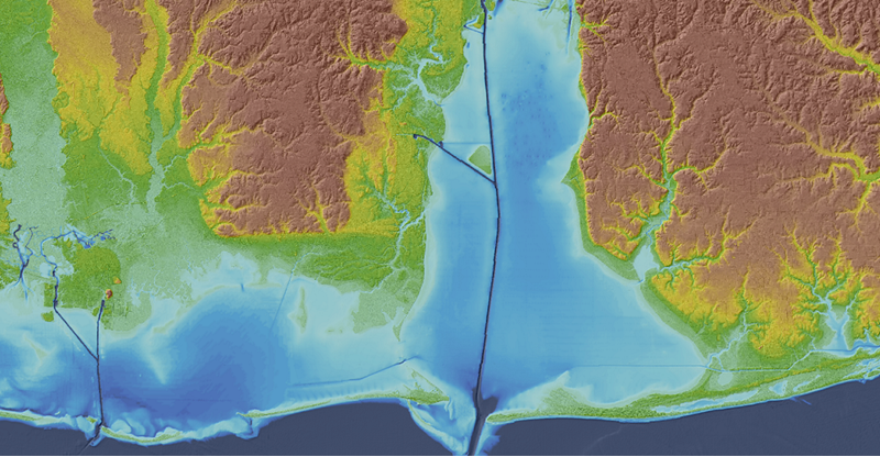
Topobathymetric Elevation Model of Mobile Bay, Alabama
Mobile Bay is ecologically important as it is the fourth largest estuary in the United States. The Mobile Bay topobathymetric digital elevation model (TBDEM) was developed in collaboration between U.S. Geological Survey (USGS) Coastal and Marine Geology Program (CMGP) and USGS National Geospatial Program (NGP) using a combination of 71 disparate topographic and bathymetric datasets collected from 1917 to 2011 by USGS, National Oceanic and Atmospheric Administration and other organizations. The topographic data were obtained primarily from USGS National Elevation Dataset at 1/9-arc-second resolution (~3 m), USGS Experimental Advanced Airborne Research Lidar (EAARL) data (2 m), and topographic lidar data (2 m) and Compact Hydrographic Airborne Rapid Total Survey (CHARTS) lidar data (2 m) from U.S. Army Corps of Engineers.
Additional information about topobathymetric elevation models is available online at https://pubs.usgs.gov/publication/ds769.
To view or download the Mobile Bay, Alabama, topobathymetric elevation model, visit the CoNED Project Viewer or The National Map Viewer.
Below are other science projects associated with this project.

Coastal National Elevation Database (CoNED) Applications Project
Coastal National Elevation Database (CoNED) Applications Project
Mobile Bay is ecologically important as it is the fourth largest estuary in the United States. The Mobile Bay topobathymetric digital elevation model (TBDEM) was developed in collaboration between U.S. Geological Survey (USGS) Coastal and Marine Geology Program (CMGP) and USGS National Geospatial Program (NGP) using a combination of 71 disparate topographic and bathymetric datasets collected from 1917 to 2011 by USGS, National Oceanic and Atmospheric Administration and other organizations. The topographic data were obtained primarily from USGS National Elevation Dataset at 1/9-arc-second resolution (~3 m), USGS Experimental Advanced Airborne Research Lidar (EAARL) data (2 m), and topographic lidar data (2 m) and Compact Hydrographic Airborne Rapid Total Survey (CHARTS) lidar data (2 m) from U.S. Army Corps of Engineers.
Additional information about topobathymetric elevation models is available online at https://pubs.usgs.gov/publication/ds769.
To view or download the Mobile Bay, Alabama, topobathymetric elevation model, visit the CoNED Project Viewer or The National Map Viewer.
Below are other science projects associated with this project.