


Inset map shows red rectangle on Alaskan North Slope corresponding to larger map, where the location of the Hydrate Well is shown as a yellow circle.
Carolyn Ruppel, PhD
Carolyn is an emerita ST Research Geophysicist who led the USGS Gas Hydrates Project from 2010 to early 2025. Gas Hydrate scientists in Woods Hole and Denver study the resource and environmental aspects of natural hydrates. Carolyn studies marine methane seeps, the interaction of hydrates with the ocean-atmosphere system, subsea permafrost, hydrate reservoir dynamics, and marine thermal regimes.
Research
Research
Highlighted Journal Articles, Data Releases, and Geonarratives
- Gas Hydrate in Nature
- Hydrate formation on marine seep bubbles and the implications for water column…
- Categorizing active marine acoustic sources based on their potential to affect …
- Elevated levels of radiocarbon in methane dissolved in seawater reveal likely l…
- Preliminary global database of known and inferred gas hydrate locations
- Methane seeps on the U.S. Atlantic margin: An updated inventory and interpretat…
HyPrCAL Laboratory
HyPrCAL Laboratory

The USGS Gas Hydrates Project manages the standalone Hydrate Pressure Core Analysis Laboratory (HyPrCAL) at the Woods Hole Coastal and Marine Science Center (WHCMSC) to study hydrate-bearing sediments in support of energy resources and geohazards research.
My primary research focus is on the interaction between methane hydrates (and methane seeps) on one hand and the ocean-atmosphere system on the other. I focus particularly on the US marine margins, especially the Atlantic, Gulf of Mexico, and Arctic (Beaufort) margins. I also work on energy issues related to gas hydrates (including delineating their distribution in marine sediments; e.g., the 2018 MATRIX seismic program on US Atlantic margin), the coexistence of permafrost (including subsea) and hydrates (Beaufort Sea), and reservoir properties of hydrate-bearing sediments. As a side specialty, I assist with programmatic environmental compliance for USGS marine acoustics surveys. I have served at least part-time in a senior advisory capacity in the USGS Chief Scientist's Office since mid-2022. During my career, I have also worked on marine heat flow data acquisition and analysis, other aspects of the hydrogeology of gas hydrate systems, and coastal zone hydrogeophysics (particularly tidal pumping, inductive EM data, and saline intrusion in surficial aquifers). My earliest work focused on numerical modeling of large scale tectonic processes and associated particle tracking, continental rifting, and marine analogs for continental tectonic processes.
Science and Products
U.S. Atlantic Margin Gas Hydrates and Methane Seeps
The U.S. Atlantic continental margin was one of the first locations where researchers recognized bottom simulating reflections, seismic features that are generally interpreted as marking the base of the gas hydrate stability zone in marine sediments. Geophysical cruises and ocean drilling in the 1990s provided insight into the Blake Ridge gas hydrate province. In the past decade, hundreds of...
Arctic Methane Dynamics
The Arctic Ocean and circum-Arctic land masses are warming more rapidly than other locations on Earth, a phenomenon called the Arctic Amplification Effect. A critical question is how this warming will affect temperature-sensitive gas hydrate deposits and methane dynamics at high latitudes. Research focuses on the contemporary distribution of gas hydrates in marine and permafrost settings; the...
Seeking the Seeps
From June 12 to July 3, 2019, the USGS sailed onboard Schmidt Ocean Institute’s R/V Falkor with several other partners, seeking methane seeps along the seafloor of several underwater canyons off the coast of Oregon and Washington. On this cruise, USGS scientists will seek to understand how much methane is coming out of these seeps, how it travels through the water column, and its ultimate fate in...
By
Ecosystems Mission Area, Natural Hazards Mission Area, Coastal and Marine Hazards and Resources Program, Pacific Coastal and Marine Science Center, St. Petersburg Coastal and Marine Science Center, Wetland and Aquatic Research Center , Woods Hole Coastal and Marine Science Center, Communications and Publishing, Deep Sea Exploration, Mapping and Characterization, Subduction Zone Science
U.S. Geological Survey Gas Hydrates Project
The USGS Gas Hydrates Project has been making contributions to advance understanding of US and international gas hydrates science for at least three decades. The research group working on gas hydrates at the USGS is among the largest in the US and has expertise in all the major geoscience disciplines, as well as in the physics and chemistry of gas hydrates, the geotechnical properties of hydrate...
The Mid-Atlantic Resource Imaging Experiment (MATRIX)
In late August 2018, scientists and technical staff from the USGS Coastal and Marine Hazards and Resources Program completed the acquisition of over 2000 km of multichannel seismic (MCS) data as part of the Mid-Atlantic Resource Imaging Experiment (MATRIX) conducted aboard the R/V Hugh R. Sharp. The seismic program was led by the USGS Gas Hydrates Project and was sponsored by the USGS, the U.S...
IMMeRSS-- Geophysical Imaging for Methane Seep Studies
Geophysical imaging relies on specialized tools to detect anomalies in the water column or to map features on or beneath the seafloor. Equipment may be towed, mounted on the side of a ship, or attached to the ship’s hull. Many geophysical techniques rely on transmitting an acoustic signal of a particular frequency and analyzing the information in the returning signal to infer the properties of the...
IMMeRSS-- Interagency Mission for Methane Research on Seafloor Seeps
From May 3 to May 11, 2017, the U.S. Geological Survey, in collaboration with the British Geological Survey and with support from these two agencies, the National Oceanic and Atmospheric Administration (NOAA) Office of Ocean Exploration and Research, and the U.S. Department of Energy, will lead an expedition aboard the R/V Hugh R. Sharp to explore seafloor methane seeps on the northern U.S...
Gas Hydrates- Atlantic Margin Methane Seeps
Analysis of 94,000 square kilometers of multibeam water column backscatter data collected by the NOAA Okeanos Explorer mostly seaward of the shelf-break on the northern US Atlantic margin reveals more than 570 gas plumes that correspond to seafloor methane seeps. This discovery is documented in an August 2014 Nature Geoscience paper entitled, "Widespread methane leakage from the seafloor on the...
Environmental Compliance
The National Environmental Policy Act of 1969 (NEPA) is the cornerstone of our Nation's environmental laws and was enacted to ensure that information on the environmental impacts of any Federal, or federally funded, action is available to public officials and citizens before decisions are made and before actions are taken
Gas Hydrates-Environment Interactions
The USGS Gas Hydrates Project focuses on the study of natural gas hydrates in deepwater marine systems and permafrost areas. Breakdown of gas hydrates due to short- or long-term warming may release methane to the ocean-atmosphere system. As a potent greenhouse gas, methane plays a role in climate warming.
Gas Hydrates- Energy
Natural gas production from methane hydrates may someday prove viable. The USGS Gas Hydrate Project takes part in US and international programs to investigate the potential of deepwater marine and permafrost gas hydrates as an energy resource. Long-term production tests are the next step in this research.
Gas Hydrates - Primer
What is Gas Hydrate? Gas hydrate is an ice-like crystalline form of water and low molecular weight gas (e.g., methane, ethane, carbon dioxide). On Earth, gas hydrates occur naturally in some marine sediments and within and beneath permafrost. Gas hydrates have also been inferred on other planets or their moons.

Hydrate Well - Alaskan North Slope
Inset map shows red rectangle on Alaskan North Slope corresponding to larger map, where the location of the Hydrate Well is shown as a yellow circle.

Hydrate Drilling Expedition
USGS scientists Steve Phillips and Adrian Garcia document and process sediment cores during the hydrate drilling expedition in November 2022.
USGS scientists Steve Phillips and Adrian Garcia document and process sediment cores during the hydrate drilling expedition in November 2022.

Arctic Hydrate Drilling
USGS geotechnical engineer Adrian Garcia on site, with the hydrates drilling rig (far right) and the core processing tent (over Adrian’s right shoulder) in the background as the Arctic sun sits low on the horizon over the tundra in November 2022.
USGS geotechnical engineer Adrian Garcia on site, with the hydrates drilling rig (far right) and the core processing tent (over Adrian’s right shoulder) in the background as the Arctic sun sits low on the horizon over the tundra in November 2022.

Gas Hydrates Lab Sites
The USGS Gas Hydrates Project analyzes the sediments that make up gas hydrate reservoirs in the Physical Properties Laboratory and manages the standalone Hydrate Pressure Core Analysis Laboratory (HyPrCAL) at the Woods Hole Coastal and Marine Science Center (WHCMSC) to study hydrate-bearing sediments in support of energy resources and geohazards research.
The USGS Gas Hydrates Project analyzes the sediments that make up gas hydrate reservoirs in the Physical Properties Laboratory and manages the standalone Hydrate Pressure Core Analysis Laboratory (HyPrCAL) at the Woods Hole Coastal and Marine Science Center (WHCMSC) to study hydrate-bearing sediments in support of energy resources and geohazards research.

Composite Results from Alaska Marine Margin Monograph Chapter
Composite results from the Alaska marine margin monograph chapter, modified from the figure by C. Ruppel and P. Hart. Red, yellow, and green lines indicate locations of seismic data lacking gas hydrate features, possibly having bottom simulating reflections (BSRs) indicative of gas hydrates, and definitely hosting BSRs, respectively.
Composite results from the Alaska marine margin monograph chapter, modified from the figure by C. Ruppel and P. Hart. Red, yellow, and green lines indicate locations of seismic data lacking gas hydrate features, possibly having bottom simulating reflections (BSRs) indicative of gas hydrates, and definitely hosting BSRs, respectively.

Gas Hydrates and Gas Bubbles
Gas hydrate (orange material) and gas bubbles near the seafloor in the northern Gulf of America. As the methane bubbles are emitted, a rind of gas hydrate immediately forms around some of them. If more bubbles continue to feed from below, gas hydrate forms.
Gas hydrate (orange material) and gas bubbles near the seafloor in the northern Gulf of America. As the methane bubbles are emitted, a rind of gas hydrate immediately forms around some of them. If more bubbles continue to feed from below, gas hydrate forms.

Retrieving Seismic Airguns
USGS personnel on the deck of the R/V Hugh R.
USGS personnel on the deck of the R/V Hugh R.
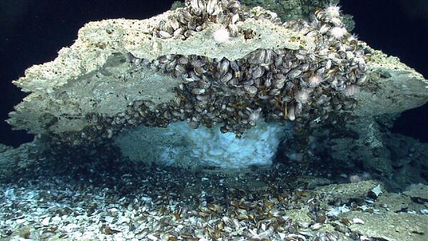
Ice-like gas hydrates under capping rock encrusted with mussels
Ice-like gas hydrates under capping rock encrusted with mussels on the sea floor of the northern Gulf of America.
Ice-like gas hydrates under capping rock encrusted with mussels on the sea floor of the northern Gulf of America.

Gas Hydrate Crystals
Scanning electron microscope image of gas hydrate crystals in a sediment sample. The scale is 50 micrometers (µm) or approximately 0.002 inches
Scanning electron microscope image of gas hydrate crystals in a sediment sample. The scale is 50 micrometers (µm) or approximately 0.002 inches

Gas Hydrates Drilling Activities
Timeline of past drilling activities conducted by countries, private sector firms, government agencies, and academe that have helped to refine global gas hydrate estimates and possible future drilling and production testing
Timeline of past drilling activities conducted by countries, private sector firms, government agencies, and academe that have helped to refine global gas hydrate estimates and possible future drilling and production testing

U.S. Atlantic Margin Seeps
Schematic showing the general setting of seeps on the US Atlantic margin and related processes, such as gas hydrate degradation, groundwater seepage, leakage through fractured rocks, or emissions from the seafloor overlying salt diapirs. Pockmarks shown in white, and the nominal updip limit of gas hydrate stability is represented by the dashed black line.
Schematic showing the general setting of seeps on the US Atlantic margin and related processes, such as gas hydrate degradation, groundwater seepage, leakage through fractured rocks, or emissions from the seafloor overlying salt diapirs. Pockmarks shown in white, and the nominal updip limit of gas hydrate stability is represented by the dashed black line.

Worldwide distribution of observed and inferred gas hydrates
Worldwide distribution of observed and inferred gas hydrates in marine and permafrost-associated settings that have been the subject of drilling programs. The color coding refers to the primary sediment type in each location and therefore designates the likely type of gas hydrate reservoir at each site.
Worldwide distribution of observed and inferred gas hydrates in marine and permafrost-associated settings that have been the subject of drilling programs. The color coding refers to the primary sediment type in each location and therefore designates the likely type of gas hydrate reservoir at each site.

Instrumented Pressure Testing Chamber (IPTC)
The Instrumented Pressure Testing Chamber (IPTC). A device for measuring the physical properties of naturally-occurring, hydrate-bearing sediment at nearly in situ pressure conditions
The Instrumented Pressure Testing Chamber (IPTC). A device for measuring the physical properties of naturally-occurring, hydrate-bearing sediment at nearly in situ pressure conditions

Hydrate Molecule
Water molecules (1 red oxygen and 2 white hydrogens) form a pentagonal dodecahedron around a methane molecule (1 gray carbon and 4 green hydrogens). This represents 2 of the 8 parts of the typical Structure I gas hydrate molecule.
Water molecules (1 red oxygen and 2 white hydrogens) form a pentagonal dodecahedron around a methane molecule (1 gray carbon and 4 green hydrogens). This represents 2 of the 8 parts of the typical Structure I gas hydrate molecule.

Schematic diagram of potential manmade hazards related to gas hydrates.
Researchers have postulated that seafloor collapse or sediment failure could occur when certain drilling and extraction activities are conducted in deepwater marine environments where gas hydrates exist in the shallow sediments. This schematic diagram, modified from Ruppel, Boswell, and Jones (2008), shows a compilation of other researchers
Researchers have postulated that seafloor collapse or sediment failure could occur when certain drilling and extraction activities are conducted in deepwater marine environments where gas hydrates exist in the shallow sediments. This schematic diagram, modified from Ruppel, Boswell, and Jones (2008), shows a compilation of other researchers

Gas Hydrates Project personnel location map.
The USGS Gas Hydrates Project integrates across USGS mission areas, programs, and regions. The stars indicate the locations of personnel involved in the Gas Hydrates Project. Within the US, much of the research focuses on the Gulf of America and Alaska, which represent marine and permafrost-associated settings for gas hydrates, respectively.
The USGS Gas Hydrates Project integrates across USGS mission areas, programs, and regions. The stars indicate the locations of personnel involved in the Gas Hydrates Project. Within the US, much of the research focuses on the Gulf of America and Alaska, which represent marine and permafrost-associated settings for gas hydrates, respectively.

Multichannel seismic line showing slope failure
1977 USGS multichannel seismic line showing slope failures on the US Beaufort Margin, the location that Kayen and Lee (1991) analyzed in their initial paper on submarine slides and gas hydrates.
1977 USGS multichannel seismic line showing slope failures on the US Beaufort Margin, the location that Kayen and Lee (1991) analyzed in their initial paper on submarine slides and gas hydrates.

USGS scientists contribute to new gas hydrates monograph
The recently-published monograph entitled World Atlas of Submarine Gas Hydrates on Continental Margins compiles findings about gas hydrates offshore all of Earth’s continents and also onshore in selected permafrost regions.
Science and Products
U.S. Atlantic Margin Gas Hydrates and Methane Seeps
The U.S. Atlantic continental margin was one of the first locations where researchers recognized bottom simulating reflections, seismic features that are generally interpreted as marking the base of the gas hydrate stability zone in marine sediments. Geophysical cruises and ocean drilling in the 1990s provided insight into the Blake Ridge gas hydrate province. In the past decade, hundreds of...
Arctic Methane Dynamics
The Arctic Ocean and circum-Arctic land masses are warming more rapidly than other locations on Earth, a phenomenon called the Arctic Amplification Effect. A critical question is how this warming will affect temperature-sensitive gas hydrate deposits and methane dynamics at high latitudes. Research focuses on the contemporary distribution of gas hydrates in marine and permafrost settings; the...
Seeking the Seeps
From June 12 to July 3, 2019, the USGS sailed onboard Schmidt Ocean Institute’s R/V Falkor with several other partners, seeking methane seeps along the seafloor of several underwater canyons off the coast of Oregon and Washington. On this cruise, USGS scientists will seek to understand how much methane is coming out of these seeps, how it travels through the water column, and its ultimate fate in...
By
Ecosystems Mission Area, Natural Hazards Mission Area, Coastal and Marine Hazards and Resources Program, Pacific Coastal and Marine Science Center, St. Petersburg Coastal and Marine Science Center, Wetland and Aquatic Research Center , Woods Hole Coastal and Marine Science Center, Communications and Publishing, Deep Sea Exploration, Mapping and Characterization, Subduction Zone Science
U.S. Geological Survey Gas Hydrates Project
The USGS Gas Hydrates Project has been making contributions to advance understanding of US and international gas hydrates science for at least three decades. The research group working on gas hydrates at the USGS is among the largest in the US and has expertise in all the major geoscience disciplines, as well as in the physics and chemistry of gas hydrates, the geotechnical properties of hydrate...
The Mid-Atlantic Resource Imaging Experiment (MATRIX)
In late August 2018, scientists and technical staff from the USGS Coastal and Marine Hazards and Resources Program completed the acquisition of over 2000 km of multichannel seismic (MCS) data as part of the Mid-Atlantic Resource Imaging Experiment (MATRIX) conducted aboard the R/V Hugh R. Sharp. The seismic program was led by the USGS Gas Hydrates Project and was sponsored by the USGS, the U.S...
IMMeRSS-- Geophysical Imaging for Methane Seep Studies
Geophysical imaging relies on specialized tools to detect anomalies in the water column or to map features on or beneath the seafloor. Equipment may be towed, mounted on the side of a ship, or attached to the ship’s hull. Many geophysical techniques rely on transmitting an acoustic signal of a particular frequency and analyzing the information in the returning signal to infer the properties of the...
IMMeRSS-- Interagency Mission for Methane Research on Seafloor Seeps
From May 3 to May 11, 2017, the U.S. Geological Survey, in collaboration with the British Geological Survey and with support from these two agencies, the National Oceanic and Atmospheric Administration (NOAA) Office of Ocean Exploration and Research, and the U.S. Department of Energy, will lead an expedition aboard the R/V Hugh R. Sharp to explore seafloor methane seeps on the northern U.S...
Gas Hydrates- Atlantic Margin Methane Seeps
Analysis of 94,000 square kilometers of multibeam water column backscatter data collected by the NOAA Okeanos Explorer mostly seaward of the shelf-break on the northern US Atlantic margin reveals more than 570 gas plumes that correspond to seafloor methane seeps. This discovery is documented in an August 2014 Nature Geoscience paper entitled, "Widespread methane leakage from the seafloor on the...
Environmental Compliance
The National Environmental Policy Act of 1969 (NEPA) is the cornerstone of our Nation's environmental laws and was enacted to ensure that information on the environmental impacts of any Federal, or federally funded, action is available to public officials and citizens before decisions are made and before actions are taken
Gas Hydrates-Environment Interactions
The USGS Gas Hydrates Project focuses on the study of natural gas hydrates in deepwater marine systems and permafrost areas. Breakdown of gas hydrates due to short- or long-term warming may release methane to the ocean-atmosphere system. As a potent greenhouse gas, methane plays a role in climate warming.
Gas Hydrates- Energy
Natural gas production from methane hydrates may someday prove viable. The USGS Gas Hydrate Project takes part in US and international programs to investigate the potential of deepwater marine and permafrost gas hydrates as an energy resource. Long-term production tests are the next step in this research.
Gas Hydrates - Primer
What is Gas Hydrate? Gas hydrate is an ice-like crystalline form of water and low molecular weight gas (e.g., methane, ethane, carbon dioxide). On Earth, gas hydrates occur naturally in some marine sediments and within and beneath permafrost. Gas hydrates have also been inferred on other planets or their moons.
Hydrate Well - Alaskan North Slope
Inset map shows red rectangle on Alaskan North Slope corresponding to larger map, where the location of the Hydrate Well is shown as a yellow circle.
Inset map shows red rectangle on Alaskan North Slope corresponding to larger map, where the location of the Hydrate Well is shown as a yellow circle.
Hydrate Drilling Expedition
USGS scientists Steve Phillips and Adrian Garcia document and process sediment cores during the hydrate drilling expedition in November 2022.
USGS scientists Steve Phillips and Adrian Garcia document and process sediment cores during the hydrate drilling expedition in November 2022.
Arctic Hydrate Drilling
USGS geotechnical engineer Adrian Garcia on site, with the hydrates drilling rig (far right) and the core processing tent (over Adrian’s right shoulder) in the background as the Arctic sun sits low on the horizon over the tundra in November 2022.
USGS geotechnical engineer Adrian Garcia on site, with the hydrates drilling rig (far right) and the core processing tent (over Adrian’s right shoulder) in the background as the Arctic sun sits low on the horizon over the tundra in November 2022.
Gas Hydrates Lab Sites
The USGS Gas Hydrates Project analyzes the sediments that make up gas hydrate reservoirs in the Physical Properties Laboratory and manages the standalone Hydrate Pressure Core Analysis Laboratory (HyPrCAL) at the Woods Hole Coastal and Marine Science Center (WHCMSC) to study hydrate-bearing sediments in support of energy resources and geohazards research.
The USGS Gas Hydrates Project analyzes the sediments that make up gas hydrate reservoirs in the Physical Properties Laboratory and manages the standalone Hydrate Pressure Core Analysis Laboratory (HyPrCAL) at the Woods Hole Coastal and Marine Science Center (WHCMSC) to study hydrate-bearing sediments in support of energy resources and geohazards research.
Composite Results from Alaska Marine Margin Monograph Chapter
Composite results from the Alaska marine margin monograph chapter, modified from the figure by C. Ruppel and P. Hart. Red, yellow, and green lines indicate locations of seismic data lacking gas hydrate features, possibly having bottom simulating reflections (BSRs) indicative of gas hydrates, and definitely hosting BSRs, respectively.
Composite results from the Alaska marine margin monograph chapter, modified from the figure by C. Ruppel and P. Hart. Red, yellow, and green lines indicate locations of seismic data lacking gas hydrate features, possibly having bottom simulating reflections (BSRs) indicative of gas hydrates, and definitely hosting BSRs, respectively.
Gas Hydrates and Gas Bubbles
Gas hydrate (orange material) and gas bubbles near the seafloor in the northern Gulf of America. As the methane bubbles are emitted, a rind of gas hydrate immediately forms around some of them. If more bubbles continue to feed from below, gas hydrate forms.
Gas hydrate (orange material) and gas bubbles near the seafloor in the northern Gulf of America. As the methane bubbles are emitted, a rind of gas hydrate immediately forms around some of them. If more bubbles continue to feed from below, gas hydrate forms.
Retrieving Seismic Airguns
USGS personnel on the deck of the R/V Hugh R.
USGS personnel on the deck of the R/V Hugh R.
Ice-like gas hydrates under capping rock encrusted with mussels
Ice-like gas hydrates under capping rock encrusted with mussels on the sea floor of the northern Gulf of America.
Ice-like gas hydrates under capping rock encrusted with mussels on the sea floor of the northern Gulf of America.
Gas Hydrate Crystals
Scanning electron microscope image of gas hydrate crystals in a sediment sample. The scale is 50 micrometers (µm) or approximately 0.002 inches
Scanning electron microscope image of gas hydrate crystals in a sediment sample. The scale is 50 micrometers (µm) or approximately 0.002 inches
Gas Hydrates Drilling Activities
Timeline of past drilling activities conducted by countries, private sector firms, government agencies, and academe that have helped to refine global gas hydrate estimates and possible future drilling and production testing
Timeline of past drilling activities conducted by countries, private sector firms, government agencies, and academe that have helped to refine global gas hydrate estimates and possible future drilling and production testing
U.S. Atlantic Margin Seeps
Schematic showing the general setting of seeps on the US Atlantic margin and related processes, such as gas hydrate degradation, groundwater seepage, leakage through fractured rocks, or emissions from the seafloor overlying salt diapirs. Pockmarks shown in white, and the nominal updip limit of gas hydrate stability is represented by the dashed black line.
Schematic showing the general setting of seeps on the US Atlantic margin and related processes, such as gas hydrate degradation, groundwater seepage, leakage through fractured rocks, or emissions from the seafloor overlying salt diapirs. Pockmarks shown in white, and the nominal updip limit of gas hydrate stability is represented by the dashed black line.
Worldwide distribution of observed and inferred gas hydrates
Worldwide distribution of observed and inferred gas hydrates in marine and permafrost-associated settings that have been the subject of drilling programs. The color coding refers to the primary sediment type in each location and therefore designates the likely type of gas hydrate reservoir at each site.
Worldwide distribution of observed and inferred gas hydrates in marine and permafrost-associated settings that have been the subject of drilling programs. The color coding refers to the primary sediment type in each location and therefore designates the likely type of gas hydrate reservoir at each site.
Instrumented Pressure Testing Chamber (IPTC)
The Instrumented Pressure Testing Chamber (IPTC). A device for measuring the physical properties of naturally-occurring, hydrate-bearing sediment at nearly in situ pressure conditions
The Instrumented Pressure Testing Chamber (IPTC). A device for measuring the physical properties of naturally-occurring, hydrate-bearing sediment at nearly in situ pressure conditions
Hydrate Molecule
Water molecules (1 red oxygen and 2 white hydrogens) form a pentagonal dodecahedron around a methane molecule (1 gray carbon and 4 green hydrogens). This represents 2 of the 8 parts of the typical Structure I gas hydrate molecule.
Water molecules (1 red oxygen and 2 white hydrogens) form a pentagonal dodecahedron around a methane molecule (1 gray carbon and 4 green hydrogens). This represents 2 of the 8 parts of the typical Structure I gas hydrate molecule.
Schematic diagram of potential manmade hazards related to gas hydrates.
Researchers have postulated that seafloor collapse or sediment failure could occur when certain drilling and extraction activities are conducted in deepwater marine environments where gas hydrates exist in the shallow sediments. This schematic diagram, modified from Ruppel, Boswell, and Jones (2008), shows a compilation of other researchers
Researchers have postulated that seafloor collapse or sediment failure could occur when certain drilling and extraction activities are conducted in deepwater marine environments where gas hydrates exist in the shallow sediments. This schematic diagram, modified from Ruppel, Boswell, and Jones (2008), shows a compilation of other researchers
Gas Hydrates Project personnel location map.
The USGS Gas Hydrates Project integrates across USGS mission areas, programs, and regions. The stars indicate the locations of personnel involved in the Gas Hydrates Project. Within the US, much of the research focuses on the Gulf of America and Alaska, which represent marine and permafrost-associated settings for gas hydrates, respectively.
The USGS Gas Hydrates Project integrates across USGS mission areas, programs, and regions. The stars indicate the locations of personnel involved in the Gas Hydrates Project. Within the US, much of the research focuses on the Gulf of America and Alaska, which represent marine and permafrost-associated settings for gas hydrates, respectively.
Multichannel seismic line showing slope failure
1977 USGS multichannel seismic line showing slope failures on the US Beaufort Margin, the location that Kayen and Lee (1991) analyzed in their initial paper on submarine slides and gas hydrates.
1977 USGS multichannel seismic line showing slope failures on the US Beaufort Margin, the location that Kayen and Lee (1991) analyzed in their initial paper on submarine slides and gas hydrates.
USGS scientists contribute to new gas hydrates monograph
The recently-published monograph entitled World Atlas of Submarine Gas Hydrates on Continental Margins compiles findings about gas hydrates offshore all of Earth’s continents and also onshore in selected permafrost regions.
*Disclaimer: Listing outside positions with professional scientific organizations on this Staff Profile are for informational purposes only and do not constitute an endorsement of those professional scientific organizations or their activities by the USGS, Department of the Interior, or U.S. Government