
...to informing restoration efforts in the Florida Everglades
...to tracking storm-related flood conditions through the South Atlantic...
...to investigating coral health in the Florida Keys & Caribbean...
...to assessing environmental contaminants on aquatic life in the Mississippi River Basin...
...USGS science spans the South Atlantic, Gulf States and Caribbean
The Southeast Region includes 13 states and two U.S. territories, Puerto Rico and the U.S. Virgin Islands
The Southeast Region includes 13 states and two U.S. territories, Puerto Rico and the U.S. Virgin Islands
Southeast Region
We conduct impartial, multi- and interdisciplinary research and monitoring to address a broad range of natural-resource issues that affect the quality of life of citizens and landscapes in the Southeastern United States and the Caribbean region.
News
AquaDePTH: Merging Aquatic Disease Surveillance Data into One Useful Tool
AquaDePTH: Merging Aquatic Disease Surveillance Data into One Useful Tool
USGS Geologic Mapping Project Supports Critical Mineral Exploration, Enhances Public Safety in the Southeast
USGS Geologic Mapping Project Supports Critical Mineral Exploration, Enhances Public Safety in the Southeast
Ecological Thresholds, Abiotic Stress, and Climate Change: A Conceptual Framework
Ecological Thresholds, Abiotic Stress, and Climate Change: A Conceptual Framework
Publications
Groundwater drought in the United States: Spatial and temporal variability Groundwater drought in the United States: Spatial and temporal variability
Many communities and ecosystems in the United States that are dependent on groundwater are potentially adversely affected by groundwater drought. We computed yearly groundwater-drought metrics and mean groundwater levels at well locations across the conterminous United States (CONUS), using data from wells and remotely sensed and modeled Gravity Recovery and Climate Experiment Drought...
Measuring storm waves and water levels from a fixed structure with a rapidly deployable oceanographic radar Measuring storm waves and water levels from a fixed structure with a rapidly deployable oceanographic radar
A new oceanographic radar instrument package was developed by the U.S. Geological Survey (USGS) to measure storm waves and water levels in the nearshore, capable of being deployed rapidly and transmitting data in near real-time. To test the performance and accuracy of the sensor, multiple years of data were collected over various hydrodynamic conditions and compared to long-term...
Hyperspectral retrieval of phytoplankton absorption and community composition from NASA’s PACE-OCI in estuarine–coastal waters using a hybrid framework combining mixture-of-experts and Variational Autoencoder Hyperspectral retrieval of phytoplankton absorption and community composition from NASA’s PACE-OCI in estuarine–coastal waters using a hybrid framework combining mixture-of-experts and Variational Autoencoder
Retrieving the phytoplankton absorption coefficient (aphy; m−1), one of the most spectrally rich inherent optical properties, remains challenging in optically complex coastal waters worldwide. Leveraging NASA's new hyperspectral mission, PACE, we introduce Hyper-MoE-VAE, a deep-learning architecture that integrates a Mixture-of-Experts with a Variational Autoencoder to retrieve high...
Science

Mobile River Basin Study
The Mobile River Basin in Alabama, Georgia, Mississippi, and Tennessee is one of the 59 study units that are part of the U.S. Geological Survey's National Water-Quality Assessment (NAWQA) Program. The long-term goals of this program are to describe the status and trends in the quality of a large, representative part of the Nation's surface- and ground-water resources, and to provide a sound...
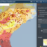
South Atlantic Water Science Center Drought Monitoring
When rainfall is less than normal for several weeks, months, or years, the flow of streams and rivers declines, water levels in lakes and reservoirs fall, and the depth to water in wells increases. If dry weather persists and water-supply problems develop, the dry period can become a drought.

Triangle Area, NC, Water Supply Monitoring
The Research Triangle area, located within the upper Cape Fear and Neuse River basins, is one of the most rapidly developing areas in the Nation. Growth has increased demand for water from public suppliers, the majority of which draw water from streams and lakes in the region. Growth also brings the threat of greater loads of contaminants and new contaminant sources that, if not properly managed...