


Several koa‘e kea birds (white-tailed tropicbirds) were flying circles above the Kīlauea summit eruptive vent on December 29, riding thermal updrafts from the lava pond. USGS photo by M. Patrick.
Read answers to Frequently-Asked-Questions about eruptions at the summit of Kīlauea
Eruptive activity at the summit of Kīlauea, within Hawaiʻi Volcanoes National Park, has been intermittent since an eruption began on December 23, 2024.
Kīlauea is in a unique phase of activity in Halemaʻumaʻu, with numerous episodes of dual lava fountains since the eruption began the night of December 23, 2024. Two eruptive vents are located in the southwest part of the caldera, referred to as the north and south vent, and they have been intermittently active, producing new lava flows over parts of Halemaʻumaʻu crater surface.
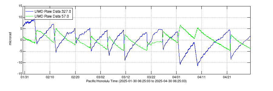
During the ongoing eruption, tiltmeters have shown inflationary tilt prior to a lava fountaining episode, as pressure builds beneath the surface, and a switch to deflationary tilt when a lava fountain episode begins, indicative of the pressure within the magma chambers being released. The switch to deflationary tilt generally defines an episode start.
This pattern of inflation and deflation with every recent lava fountain episode creates a saw-tooth pattern in ground tilt records over the past several months (see the plot below); however, Kīlauea summit has shown little net change in pressurization since the eruption began on December 23, 2024. This indicates that Kīlauea summit has been in some level of equilibrium since the eruption began. The north and south eruptive vents in Halemaʻumaʻu are able to incrementally release the pressure that accumulates within Kīlauea summit magma chambers with each eruptive episode.
Electronic Tilt at Kīlauea Summit and East Rift Zone - Past Three Months
Media
Remote image Url
Sources/Usage: Public Domain. View Media Details
Timeline of Eruptive Episodes
All times in the table below are Hawaiian Standard Time (HST).
| Episode Number | Start Date/Time (HST) | Pause Date/Time (HST) | Eruptive Episode Duration | Pause Duration Following Episode |
| 1 | December 23, 2024 - 2:20 a.m. | December 23, 2024 - 4 p.m. | 14 hours | 16 hours |
| 2 | December 24, 2024 - 8 a.m. | December 25, 2024 - 11 a.m. | 27 hours | 1 day |
| 3 | December 26, 2024 - 8 a.m. | January 3, 2025 - 8:30 p.m. | 8.5 days | 12 days |
| 4 | January 15, 2025 - 9 a.m. | January 18, 2025 - 10:10 a.m. | 3 days | 4 days |
| 5 | January 22, 2025 - 2:30 p.m. | January 23, 2025 - 4:30 a.m. | 14 hours | 2 days |
| 6 | January 24, 2025 - 11:28 p.m. | January 25, 2025 - 12:36 p.m. | 13 hours | 2 days |
| 7 | January 27, 2025 - 6:41 p.m. | January 28, 2025 - 10:41 a.m. | 16 hours | 6 days |
| 8 | February 3, 2025 - 9:52 p.m. | February 4, 2025 - 7:23 p.m. | 22 hours | 6 days |
| 9 | February 11, 2025 - 10:16 a.m. | February 12, 2025 - 8:43 a.m. | 22 hours | 7 days |
| 10 | February 19, 2025 - 8:22 p.m. | February 20, 2025 - 9:18 a.m. | 13 hours | 5 days |
| 11 | February 25, 2025 - 6:26 p.m. | February 26, 2025 - 7:06 a.m. | 13 hours | 6 days |
| 12 | March 4, 2025 - 7:30 a.m. | March 5, 2025 - 10:37 a.m. | 27 hours | 6 days |
| 13 | March 11, 2025 - 2:36 a.m. | March 11, 2025 - 3:13 p.m. | 13 hours | 8 days |
| 14 | March 19, 2025 - 9:26 a.m. | March 20, 2025 - 1:49 p.m. | 28 hours | 5 days |
| 15 | March 25, 2025 - 12:04 p.m. | March 26, 2025 - 7:10 p.m. | 31 hours | 5 days |
| 16 | March 31, 2025 - 10:57 p.m. | April 2, 2025 - 12:04 p.m. | 37 hours | 7 days |
| 17 | April 7, 2025 - 10:15 p.m. | April 9, 2025 - 9:45 a.m. | 35.5 hours | 9 days |
| 18 | April 16, 2025 - 10:01 p.m. (precursory low-level activity), April 22, 2025 - 3:30 a.m. (fountaining phase) | April 22, 2025 - 1:28 p.m. | 10 hours (fountaining phase) | 11 days |
| 19 | May 1, 2025 - 11:49 a.m. (precursory low-level activity) May 1, 2025 - 9:28 p.m. (fountaining phase) | May 2, 2025 - 5:20 a.m. | 8 hours (fountaining phase) | 3 days |
| 20 | May 5, 2024 - 10:48 a.m. (precursory low-level activity) May 6, 2025 - 5:28 p.m. (fountaining phase) | May 6, 2025 - 9:28 p.m. | 4.5 hours (fountaining phase) | 5 days |
| 21 | May 11, 2025 - 12:45 p.m. (fountaining phase) | May 11, 2025 - 8:36 p.m. | 8 hours (fountaining phase) | ongoing |
Latest eruption maps
Media

This reference map depicts the Kīlauea summit eruption within Halema‘uma‘u crater that began on December 23, 2024. As of this posting on April 30, 2025, the eruption has had eighteen episodes, with the most recent occurring on April 22. Most of the map data included here were collected during a Hawaiian Volcano Observatory helicopter overflight on April 29, so the provided statistics are reflective of the entire eruption to this point.
Sources/Usage: Public Domain. View Media Details
Media

This thermal map was taken on the 7 a.m. overflight of Kīlauea summit on April 9, 2025, and shows the expansive lava flow covering the floor of Halema‘uma‘u, supplied by lava fountains at the vent. As in earlier episodes, the lava exited the vent into a short channel that fed a broad perched lava pond. Lava channels then drained this pond and carried lava farther to the east. A small ooze-out, fed by lava supplied beneath the solidified crater floor, was present in the south portion of the crater. The fountaining ended a few hours after the flight, ending episode 17.
Sources/Usage: Public Domain. View Media Details
Additional Information
- Search for past volcano updates
- Subscribe to the USGS Volcano Notification Service to receive eruption updates
- Kīlauea geology and history
- Kīlauea Maps
- Vog Information Dashboard
- General Hawai‘i County Civil Defense information or subscribe to CD alerts and updates
- Follow USGS Volcanoes on Twitter, Facebook, and Instagram.
- Volcano viewing information from Hawaii Volcanoes National Park
Recent eruptions have taken place within Hawai‘i Volcanoes National Park. Please visit the Park website to learn more about their operations.

December 23, 2024 - Kīlauea summit eruption
This video, taken from the west rim of Kaluapele (Kīlauea caldera), in the closed area of Hawaiʻi Volcanoes National Park, shows the new eruption that started this morning at 2:20 a.m. HST. At approximately 4:30 a.m. HST, the lava fountains were reaching up to 80 meters (260 feet) and by 5:30 a.m., lava covered an area of approximately 400 acres on the caldera floor. USGS video by D. Downs.
Filter Total Items: 71
December 29, 2024 — Koa‘e kea above eruptive vents in Halemaʻumaʻu
Several koa‘e kea birds (white-tailed tropicbirds) were flying circles above the Kīlauea summit eruptive vent on December 29, riding thermal updrafts from the lava pond. USGS photo by M. Patrick.

December 29, 2024 — Geologist monitors eruption in Halemaʻumaʻu
On December 29, Hawaiian Volcano Observatory geologists collected scaled video of lava fountaining as well as laser rangefinder measurements of fountain heights and crater floor elevations. USGS photo by M. Patrick.
On December 29, Hawaiian Volcano Observatory geologists collected scaled video of lava fountaining as well as laser rangefinder measurements of fountain heights and crater floor elevations. USGS photo by M. Patrick.

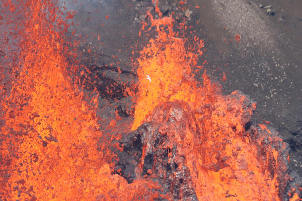
December 29, 2024 — Increased fountaining vigor at Kīlauea summit
A telephoto view of the fountaining within Kaluapele (Kīlauea summit caldera) observed by USGS Hawaiian Volcano Observatory geologists the morning of December 29 from the south rim of the crater. USGS photo by M. Patrick.
A telephoto view of the fountaining within Kaluapele (Kīlauea summit caldera) observed by USGS Hawaiian Volcano Observatory geologists the morning of December 29 from the south rim of the crater. USGS photo by M. Patrick.
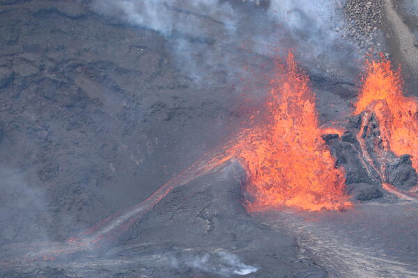
December 29, 2024 — Spatter-fed lava flow in Halemaʻumaʻu
Sufficient spatter was being deposited to produce a spatter-fed flow down the steep eruptive vent rampart at Kīlauea summit on December 29. USGS photo by M. Patrick.
Sufficient spatter was being deposited to produce a spatter-fed flow down the steep eruptive vent rampart at Kīlauea summit on December 29. USGS photo by M. Patrick.

December 29, 2024 — Rainbow over eruption in Halemaʻumaʻu
Passing showers on the morning of December 29 at Kīlauea summit produced a rainbow (known in Hawaiian as an "Ānuenue") visible near the active lava fountaining. USGS photo by M. Patrick.
Passing showers on the morning of December 29 at Kīlauea summit produced a rainbow (known in Hawaiian as an "Ānuenue") visible near the active lava fountaining. USGS photo by M. Patrick.

December 29, 2024 — Increased fountaining vigor at Kīlauea summit
Fountaining at Kīlauea summit has increased in vigor on December 29. USGS Hawaiian Volcano Observatory geologists on the crater rim the morning of December 29 observed an increase in height throughout their field shift, up to about 40 m (130 feet). Lava effusion was also starting to form a perched lava pond in front of the vents. USGS photo by M. Patrick.
Fountaining at Kīlauea summit has increased in vigor on December 29. USGS Hawaiian Volcano Observatory geologists on the crater rim the morning of December 29 observed an increase in height throughout their field shift, up to about 40 m (130 feet). Lava effusion was also starting to form a perched lava pond in front of the vents. USGS photo by M. Patrick.

December 29, 2024 — Zoom view of eruptive vents in Halemaʻumaʻu
This photo was taken later on December 29, when lava fountains at Kīlauea's summit were approximately 130 feet (40 meters) high. USGS photo by M. Patrick.
This photo was taken later on December 29, when lava fountains at Kīlauea's summit were approximately 130 feet (40 meters) high. USGS photo by M. Patrick.
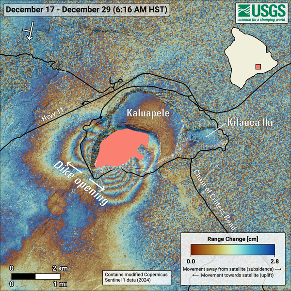
December 29, 2024—InSAR image of Kīlauea deformation associated with ongoing eruption
This map shows deformation at Kīlauea volcano associated with the ongoing eruption that started on December 23, 2024. The image covers the timespan from December 17–29, 2024, using data acquired by the European Space Agency's Sentinel-1A satellite. Colored fringes denote areas of ground deformation, with more fringes indicating more deformation. Each
This map shows deformation at Kīlauea volcano associated with the ongoing eruption that started on December 23, 2024. The image covers the timespan from December 17–29, 2024, using data acquired by the European Space Agency's Sentinel-1A satellite. Colored fringes denote areas of ground deformation, with more fringes indicating more deformation. Each
December 29, 2024 — Increased fountaining vigor at Kīlauea summit
This video shows lava fountaining within Kaluapele (Kīlauea summit caldera) on the morning of December 29, 2024, as viewed from the south rim of the crater by USGS Hawaiian Volcano Observatory geologists. USGS video by M. Patrick
This video shows lava fountaining within Kaluapele (Kīlauea summit caldera) on the morning of December 29, 2024, as viewed from the south rim of the crater by USGS Hawaiian Volcano Observatory geologists. USGS video by M. Patrick
December 29, 2024 — Increased fountaining vigor at Kīlauea summit
Fountaining at Kīlauea summit increased in vigor on December 29. USGS Hawaiian Volcano Observatory geologists on the crater rim the morning of December 29 observed an increase in height throughout their field shift, up to about 40 m (130 feet). Lava effusion was also starting to form a perched lava pond in front of the vents. USGS video by M. Patrick.
Fountaining at Kīlauea summit increased in vigor on December 29. USGS Hawaiian Volcano Observatory geologists on the crater rim the morning of December 29 observed an increase in height throughout their field shift, up to about 40 m (130 feet). Lava effusion was also starting to form a perched lava pond in front of the vents. USGS video by M. Patrick.
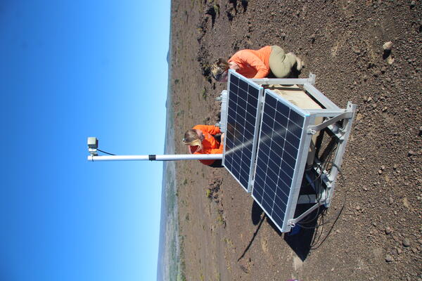
December 28, 2024 — Gas monitoring station repairs
Maintenance of the Hawaiian Volcano Observatory's instrumental monitoring network is an ever-ongoing process, but it is especially important during eruptions. Here, two scientists perform repairs on a gas monitoring station located just west of Kaluapele—Kīlauea's summit caldera—on Saturday, December 28, 2024.
Maintenance of the Hawaiian Volcano Observatory's instrumental monitoring network is an ever-ongoing process, but it is especially important during eruptions. Here, two scientists perform repairs on a gas monitoring station located just west of Kaluapele—Kīlauea's summit caldera—on Saturday, December 28, 2024.

December 28, 2024 — Zoom view of eruptive vents within Halemaʻumaʻu
This zoom view of the three active eruptive vents within Halemaʻumaʻu was captured during a morning visit to the crater's southern rim by Hawaiian Volcano Observatory geologists on Saturday, December 28, 2024.
This zoom view of the three active eruptive vents within Halemaʻumaʻu was captured during a morning visit to the crater's southern rim by Hawaiian Volcano Observatory geologists on Saturday, December 28, 2024.

December 28, 2024 — Overview of eruption in Halemaʻumaʻu from southern crater rim
Hawaiian Volcano Observatory geologists captured this overview photo of Kīlauea's summit eruption within Halemaʻumaʻu during a morning visit to the crater's southern rim on Saturday, December 28, 2024. Three eruptive vents were active at the time, spattering and feeding lava flows that spread out in a fan shape on the southwestern crater floor. USGS photo by M.
Hawaiian Volcano Observatory geologists captured this overview photo of Kīlauea's summit eruption within Halemaʻumaʻu during a morning visit to the crater's southern rim on Saturday, December 28, 2024. Three eruptive vents were active at the time, spattering and feeding lava flows that spread out in a fan shape on the southwestern crater floor. USGS photo by M.

December 27, 2024 — Kīlauea eruptive activity on December 27, 2024
Eruptive activity at Kīlauea around 7 a.m. HST on December 27, 2024, was minimal, with only a few sluggish lava flows oozing out from one of the vents that formed over the past few days. USGS photo by K. Lynn.
Eruptive activity at Kīlauea around 7 a.m. HST on December 27, 2024, was minimal, with only a few sluggish lava flows oozing out from one of the vents that formed over the past few days. USGS photo by K. Lynn.

December 27, 2024 — Low-level view of eruptive vents in western wall of Halema‘uma‘u, Kīlauea
During a helicopter overflight on the morning of Friday, December 27, 2024, USGS Hawaiian Volcano Observatory geologists were provided a low-level view of the eruptive vents in the western wall of Halema‘uma‘u crater at the summit of Kīlauea volcano.
During a helicopter overflight on the morning of Friday, December 27, 2024, USGS Hawaiian Volcano Observatory geologists were provided a low-level view of the eruptive vents in the western wall of Halema‘uma‘u crater at the summit of Kīlauea volcano.

December 27, 2024 — Kīlauea eruption overflight
USGS Hawaiian Volcano Observatory geologists conducted an overflight on the morning of Friday, December 27, 2024, of the ongoing Kīlauea summit eruption within Halema‘uma‘u crater.
USGS Hawaiian Volcano Observatory geologists conducted an overflight on the morning of Friday, December 27, 2024, of the ongoing Kīlauea summit eruption within Halema‘uma‘u crater.

December 27, 2024 — Helicopter o verflight of December 2024 Halema‘uma‘u eruption, Kīlauea
This aerial view shows the June 2023 vent on the south side of Halema‘uma‘u crater during a helicopter overflight at 10 a.m. HST on December 27, 2024. Pauses in the recent eruption that began on December 23 have resulted in drainback, during which some of the erupted lava drains back into the vent.
This aerial view shows the June 2023 vent on the south side of Halema‘uma‘u crater during a helicopter overflight at 10 a.m. HST on December 27, 2024. Pauses in the recent eruption that began on December 23 have resulted in drainback, during which some of the erupted lava drains back into the vent.
December 27, 2024 — Aerial overview of eruption in Halema‘uma‘u, Kīlauea
This oblique aerial photo was captured during a USGS Hawaiian Volcano Observatory overflight on the morning of Friday, December 27, 2024, providing a northeast-looking overview of the ongoing Kīlauea summit eruption within Halema‘uma‘u crater.
This oblique aerial photo was captured during a USGS Hawaiian Volcano Observatory overflight on the morning of Friday, December 27, 2024, providing a northeast-looking overview of the ongoing Kīlauea summit eruption within Halema‘uma‘u crater.

December 27, 2024 — Kīlauea lava flow activity
During the morning of December 27, 2024, USGS Hawaiian Volcano Observatory field crews observed only weak effusive activity at the December 23-27, 2024, eruptive vents in Halema‘uma‘u. USGS photo by K. Lynn.
During the morning of December 27, 2024, USGS Hawaiian Volcano Observatory field crews observed only weak effusive activity at the December 23-27, 2024, eruptive vents in Halema‘uma‘u. USGS photo by K. Lynn.

December 27, 2024 — Remnants of "the island" in Halema‘uma‘u, Kīlauea
Since the December 2020 eruption began, an "island" of low-density tephra and lava has been submerged and floated on the surface of the Halema‘uma‘u lava lake through each successive eruption.
Since the December 2020 eruption began, an "island" of low-density tephra and lava has been submerged and floated on the surface of the Halema‘uma‘u lava lake through each successive eruption.

December 27, 2024 — Kīlauea eruptive activity December, 26-27, 2024
During a helicopter overflight on December 27, 2024, USGS Hawaiian Volcano Observatory field crews captured this view of the lava "pad" that formed during weak effusive activity from December 26-27, 2024, during weak effusive activity.
During a helicopter overflight on December 27, 2024, USGS Hawaiian Volcano Observatory field crews captured this view of the lava "pad" that formed during weak effusive activity from December 26-27, 2024, during weak effusive activity.
Eruptive activity at the summit of Kīlauea, within Hawaiʻi Volcanoes National Park, has been intermittent since an eruption began on December 23, 2024.
Kīlauea is in a unique phase of activity in Halemaʻumaʻu, with numerous episodes of dual lava fountains since the eruption began the night of December 23, 2024. Two eruptive vents are located in the southwest part of the caldera, referred to as the north and south vent, and they have been intermittently active, producing new lava flows over parts of Halemaʻumaʻu crater surface.
During the ongoing eruption, tiltmeters have shown inflationary tilt prior to a lava fountaining episode, as pressure builds beneath the surface, and a switch to deflationary tilt when a lava fountain episode begins, indicative of the pressure within the magma chambers being released. The switch to deflationary tilt generally defines an episode start.
This pattern of inflation and deflation with every recent lava fountain episode creates a saw-tooth pattern in ground tilt records over the past several months (see the plot below); however, Kīlauea summit has shown little net change in pressurization since the eruption began on December 23, 2024. This indicates that Kīlauea summit has been in some level of equilibrium since the eruption began. The north and south eruptive vents in Halemaʻumaʻu are able to incrementally release the pressure that accumulates within Kīlauea summit magma chambers with each eruptive episode.
Electronic Tilt at Kīlauea Summit and East Rift Zone - Past Three Months
Media
Remote image Url
Sources/Usage: Public Domain. View Media Details
Timeline of Eruptive Episodes
All times in the table below are Hawaiian Standard Time (HST).
| Episode Number | Start Date/Time (HST) | Pause Date/Time (HST) | Eruptive Episode Duration | Pause Duration Following Episode |
| 1 | December 23, 2024 - 2:20 a.m. | December 23, 2024 - 4 p.m. | 14 hours | 16 hours |
| 2 | December 24, 2024 - 8 a.m. | December 25, 2024 - 11 a.m. | 27 hours | 1 day |
| 3 | December 26, 2024 - 8 a.m. | January 3, 2025 - 8:30 p.m. | 8.5 days | 12 days |
| 4 | January 15, 2025 - 9 a.m. | January 18, 2025 - 10:10 a.m. | 3 days | 4 days |
| 5 | January 22, 2025 - 2:30 p.m. | January 23, 2025 - 4:30 a.m. | 14 hours | 2 days |
| 6 | January 24, 2025 - 11:28 p.m. | January 25, 2025 - 12:36 p.m. | 13 hours | 2 days |
| 7 | January 27, 2025 - 6:41 p.m. | January 28, 2025 - 10:41 a.m. | 16 hours | 6 days |
| 8 | February 3, 2025 - 9:52 p.m. | February 4, 2025 - 7:23 p.m. | 22 hours | 6 days |
| 9 | February 11, 2025 - 10:16 a.m. | February 12, 2025 - 8:43 a.m. | 22 hours | 7 days |
| 10 | February 19, 2025 - 8:22 p.m. | February 20, 2025 - 9:18 a.m. | 13 hours | 5 days |
| 11 | February 25, 2025 - 6:26 p.m. | February 26, 2025 - 7:06 a.m. | 13 hours | 6 days |
| 12 | March 4, 2025 - 7:30 a.m. | March 5, 2025 - 10:37 a.m. | 27 hours | 6 days |
| 13 | March 11, 2025 - 2:36 a.m. | March 11, 2025 - 3:13 p.m. | 13 hours | 8 days |
| 14 | March 19, 2025 - 9:26 a.m. | March 20, 2025 - 1:49 p.m. | 28 hours | 5 days |
| 15 | March 25, 2025 - 12:04 p.m. | March 26, 2025 - 7:10 p.m. | 31 hours | 5 days |
| 16 | March 31, 2025 - 10:57 p.m. | April 2, 2025 - 12:04 p.m. | 37 hours | 7 days |
| 17 | April 7, 2025 - 10:15 p.m. | April 9, 2025 - 9:45 a.m. | 35.5 hours | 9 days |
| 18 | April 16, 2025 - 10:01 p.m. (precursory low-level activity), April 22, 2025 - 3:30 a.m. (fountaining phase) | April 22, 2025 - 1:28 p.m. | 10 hours (fountaining phase) | 11 days |
| 19 | May 1, 2025 - 11:49 a.m. (precursory low-level activity) May 1, 2025 - 9:28 p.m. (fountaining phase) | May 2, 2025 - 5:20 a.m. | 8 hours (fountaining phase) | 3 days |
| 20 | May 5, 2024 - 10:48 a.m. (precursory low-level activity) May 6, 2025 - 5:28 p.m. (fountaining phase) | May 6, 2025 - 9:28 p.m. | 4.5 hours (fountaining phase) | 5 days |
| 21 | May 11, 2025 - 12:45 p.m. (fountaining phase) | May 11, 2025 - 8:36 p.m. | 8 hours (fountaining phase) | ongoing |
Latest eruption maps
Media
This reference map depicts the Kīlauea summit eruption within Halema‘uma‘u crater that began on December 23, 2024. As of this posting on April 30, 2025, the eruption has had eighteen episodes, with the most recent occurring on April 22. Most of the map data included here were collected during a Hawaiian Volcano Observatory helicopter overflight on April 29, so the provided statistics are reflective of the entire eruption to this point.
Sources/Usage: Public Domain. View Media Details
Media
This thermal map was taken on the 7 a.m. overflight of Kīlauea summit on April 9, 2025, and shows the expansive lava flow covering the floor of Halema‘uma‘u, supplied by lava fountains at the vent. As in earlier episodes, the lava exited the vent into a short channel that fed a broad perched lava pond. Lava channels then drained this pond and carried lava farther to the east. A small ooze-out, fed by lava supplied beneath the solidified crater floor, was present in the south portion of the crater. The fountaining ended a few hours after the flight, ending episode 17.
Sources/Usage: Public Domain. View Media Details
Additional Information
- Search for past volcano updates
- Subscribe to the USGS Volcano Notification Service to receive eruption updates
- Kīlauea geology and history
- Kīlauea Maps
- Vog Information Dashboard
- General Hawai‘i County Civil Defense information or subscribe to CD alerts and updates
- Follow USGS Volcanoes on Twitter, Facebook, and Instagram.
- Volcano viewing information from Hawaii Volcanoes National Park
Recent eruptions have taken place within Hawai‘i Volcanoes National Park. Please visit the Park website to learn more about their operations.
December 23, 2024 - Kīlauea summit eruption
This video, taken from the west rim of Kaluapele (Kīlauea caldera), in the closed area of Hawaiʻi Volcanoes National Park, shows the new eruption that started this morning at 2:20 a.m. HST. At approximately 4:30 a.m. HST, the lava fountains were reaching up to 80 meters (260 feet) and by 5:30 a.m., lava covered an area of approximately 400 acres on the caldera floor. USGS video by D. Downs.
Filter Total Items: 71
December 29, 2024 — Koa‘e kea above eruptive vents in Halemaʻumaʻu
Several koa‘e kea birds (white-tailed tropicbirds) were flying circles above the Kīlauea summit eruptive vent on December 29, riding thermal updrafts from the lava pond. USGS photo by M. Patrick.
Several koa‘e kea birds (white-tailed tropicbirds) were flying circles above the Kīlauea summit eruptive vent on December 29, riding thermal updrafts from the lava pond. USGS photo by M. Patrick.
December 29, 2024 — Geologist monitors eruption in Halemaʻumaʻu
On December 29, Hawaiian Volcano Observatory geologists collected scaled video of lava fountaining as well as laser rangefinder measurements of fountain heights and crater floor elevations. USGS photo by M. Patrick.
On December 29, Hawaiian Volcano Observatory geologists collected scaled video of lava fountaining as well as laser rangefinder measurements of fountain heights and crater floor elevations. USGS photo by M. Patrick.
December 29, 2024 — Increased fountaining vigor at Kīlauea summit
A telephoto view of the fountaining within Kaluapele (Kīlauea summit caldera) observed by USGS Hawaiian Volcano Observatory geologists the morning of December 29 from the south rim of the crater. USGS photo by M. Patrick.
A telephoto view of the fountaining within Kaluapele (Kīlauea summit caldera) observed by USGS Hawaiian Volcano Observatory geologists the morning of December 29 from the south rim of the crater. USGS photo by M. Patrick.
December 29, 2024 — Spatter-fed lava flow in Halemaʻumaʻu
Sufficient spatter was being deposited to produce a spatter-fed flow down the steep eruptive vent rampart at Kīlauea summit on December 29. USGS photo by M. Patrick.
Sufficient spatter was being deposited to produce a spatter-fed flow down the steep eruptive vent rampart at Kīlauea summit on December 29. USGS photo by M. Patrick.
December 29, 2024 — Rainbow over eruption in Halemaʻumaʻu
Passing showers on the morning of December 29 at Kīlauea summit produced a rainbow (known in Hawaiian as an "Ānuenue") visible near the active lava fountaining. USGS photo by M. Patrick.
Passing showers on the morning of December 29 at Kīlauea summit produced a rainbow (known in Hawaiian as an "Ānuenue") visible near the active lava fountaining. USGS photo by M. Patrick.
December 29, 2024 — Increased fountaining vigor at Kīlauea summit
Fountaining at Kīlauea summit has increased in vigor on December 29. USGS Hawaiian Volcano Observatory geologists on the crater rim the morning of December 29 observed an increase in height throughout their field shift, up to about 40 m (130 feet). Lava effusion was also starting to form a perched lava pond in front of the vents. USGS photo by M. Patrick.
Fountaining at Kīlauea summit has increased in vigor on December 29. USGS Hawaiian Volcano Observatory geologists on the crater rim the morning of December 29 observed an increase in height throughout their field shift, up to about 40 m (130 feet). Lava effusion was also starting to form a perched lava pond in front of the vents. USGS photo by M. Patrick.
December 29, 2024 — Zoom view of eruptive vents in Halemaʻumaʻu
This photo was taken later on December 29, when lava fountains at Kīlauea's summit were approximately 130 feet (40 meters) high. USGS photo by M. Patrick.
This photo was taken later on December 29, when lava fountains at Kīlauea's summit were approximately 130 feet (40 meters) high. USGS photo by M. Patrick.
December 29, 2024—InSAR image of Kīlauea deformation associated with ongoing eruption
This map shows deformation at Kīlauea volcano associated with the ongoing eruption that started on December 23, 2024. The image covers the timespan from December 17–29, 2024, using data acquired by the European Space Agency's Sentinel-1A satellite. Colored fringes denote areas of ground deformation, with more fringes indicating more deformation. Each
This map shows deformation at Kīlauea volcano associated with the ongoing eruption that started on December 23, 2024. The image covers the timespan from December 17–29, 2024, using data acquired by the European Space Agency's Sentinel-1A satellite. Colored fringes denote areas of ground deformation, with more fringes indicating more deformation. Each
December 29, 2024 — Increased fountaining vigor at Kīlauea summit
This video shows lava fountaining within Kaluapele (Kīlauea summit caldera) on the morning of December 29, 2024, as viewed from the south rim of the crater by USGS Hawaiian Volcano Observatory geologists. USGS video by M. Patrick
This video shows lava fountaining within Kaluapele (Kīlauea summit caldera) on the morning of December 29, 2024, as viewed from the south rim of the crater by USGS Hawaiian Volcano Observatory geologists. USGS video by M. Patrick
December 29, 2024 — Increased fountaining vigor at Kīlauea summit
Fountaining at Kīlauea summit increased in vigor on December 29. USGS Hawaiian Volcano Observatory geologists on the crater rim the morning of December 29 observed an increase in height throughout their field shift, up to about 40 m (130 feet). Lava effusion was also starting to form a perched lava pond in front of the vents. USGS video by M. Patrick.
Fountaining at Kīlauea summit increased in vigor on December 29. USGS Hawaiian Volcano Observatory geologists on the crater rim the morning of December 29 observed an increase in height throughout their field shift, up to about 40 m (130 feet). Lava effusion was also starting to form a perched lava pond in front of the vents. USGS video by M. Patrick.
December 28, 2024 — Gas monitoring station repairs
Maintenance of the Hawaiian Volcano Observatory's instrumental monitoring network is an ever-ongoing process, but it is especially important during eruptions. Here, two scientists perform repairs on a gas monitoring station located just west of Kaluapele—Kīlauea's summit caldera—on Saturday, December 28, 2024.
Maintenance of the Hawaiian Volcano Observatory's instrumental monitoring network is an ever-ongoing process, but it is especially important during eruptions. Here, two scientists perform repairs on a gas monitoring station located just west of Kaluapele—Kīlauea's summit caldera—on Saturday, December 28, 2024.
December 28, 2024 — Zoom view of eruptive vents within Halemaʻumaʻu
This zoom view of the three active eruptive vents within Halemaʻumaʻu was captured during a morning visit to the crater's southern rim by Hawaiian Volcano Observatory geologists on Saturday, December 28, 2024.
This zoom view of the three active eruptive vents within Halemaʻumaʻu was captured during a morning visit to the crater's southern rim by Hawaiian Volcano Observatory geologists on Saturday, December 28, 2024.
December 28, 2024 — Overview of eruption in Halemaʻumaʻu from southern crater rim
Hawaiian Volcano Observatory geologists captured this overview photo of Kīlauea's summit eruption within Halemaʻumaʻu during a morning visit to the crater's southern rim on Saturday, December 28, 2024. Three eruptive vents were active at the time, spattering and feeding lava flows that spread out in a fan shape on the southwestern crater floor. USGS photo by M.
Hawaiian Volcano Observatory geologists captured this overview photo of Kīlauea's summit eruption within Halemaʻumaʻu during a morning visit to the crater's southern rim on Saturday, December 28, 2024. Three eruptive vents were active at the time, spattering and feeding lava flows that spread out in a fan shape on the southwestern crater floor. USGS photo by M.
December 27, 2024 — Kīlauea eruptive activity on December 27, 2024
Eruptive activity at Kīlauea around 7 a.m. HST on December 27, 2024, was minimal, with only a few sluggish lava flows oozing out from one of the vents that formed over the past few days. USGS photo by K. Lynn.
Eruptive activity at Kīlauea around 7 a.m. HST on December 27, 2024, was minimal, with only a few sluggish lava flows oozing out from one of the vents that formed over the past few days. USGS photo by K. Lynn.
December 27, 2024 — Low-level view of eruptive vents in western wall of Halema‘uma‘u, Kīlauea
During a helicopter overflight on the morning of Friday, December 27, 2024, USGS Hawaiian Volcano Observatory geologists were provided a low-level view of the eruptive vents in the western wall of Halema‘uma‘u crater at the summit of Kīlauea volcano.
During a helicopter overflight on the morning of Friday, December 27, 2024, USGS Hawaiian Volcano Observatory geologists were provided a low-level view of the eruptive vents in the western wall of Halema‘uma‘u crater at the summit of Kīlauea volcano.
December 27, 2024 — Kīlauea eruption overflight
USGS Hawaiian Volcano Observatory geologists conducted an overflight on the morning of Friday, December 27, 2024, of the ongoing Kīlauea summit eruption within Halema‘uma‘u crater.
USGS Hawaiian Volcano Observatory geologists conducted an overflight on the morning of Friday, December 27, 2024, of the ongoing Kīlauea summit eruption within Halema‘uma‘u crater.
December 27, 2024 — Helicopter o verflight of December 2024 Halema‘uma‘u eruption, Kīlauea
This aerial view shows the June 2023 vent on the south side of Halema‘uma‘u crater during a helicopter overflight at 10 a.m. HST on December 27, 2024. Pauses in the recent eruption that began on December 23 have resulted in drainback, during which some of the erupted lava drains back into the vent.
This aerial view shows the June 2023 vent on the south side of Halema‘uma‘u crater during a helicopter overflight at 10 a.m. HST on December 27, 2024. Pauses in the recent eruption that began on December 23 have resulted in drainback, during which some of the erupted lava drains back into the vent.
December 27, 2024 — Aerial overview of eruption in Halema‘uma‘u, Kīlauea
This oblique aerial photo was captured during a USGS Hawaiian Volcano Observatory overflight on the morning of Friday, December 27, 2024, providing a northeast-looking overview of the ongoing Kīlauea summit eruption within Halema‘uma‘u crater.
This oblique aerial photo was captured during a USGS Hawaiian Volcano Observatory overflight on the morning of Friday, December 27, 2024, providing a northeast-looking overview of the ongoing Kīlauea summit eruption within Halema‘uma‘u crater.
December 27, 2024 — Kīlauea lava flow activity
During the morning of December 27, 2024, USGS Hawaiian Volcano Observatory field crews observed only weak effusive activity at the December 23-27, 2024, eruptive vents in Halema‘uma‘u. USGS photo by K. Lynn.
During the morning of December 27, 2024, USGS Hawaiian Volcano Observatory field crews observed only weak effusive activity at the December 23-27, 2024, eruptive vents in Halema‘uma‘u. USGS photo by K. Lynn.
December 27, 2024 — Remnants of "the island" in Halema‘uma‘u, Kīlauea
Since the December 2020 eruption began, an "island" of low-density tephra and lava has been submerged and floated on the surface of the Halema‘uma‘u lava lake through each successive eruption.
Since the December 2020 eruption began, an "island" of low-density tephra and lava has been submerged and floated on the surface of the Halema‘uma‘u lava lake through each successive eruption.
December 27, 2024 — Kīlauea eruptive activity December, 26-27, 2024
During a helicopter overflight on December 27, 2024, USGS Hawaiian Volcano Observatory field crews captured this view of the lava "pad" that formed during weak effusive activity from December 26-27, 2024, during weak effusive activity.
During a helicopter overflight on December 27, 2024, USGS Hawaiian Volcano Observatory field crews captured this view of the lava "pad" that formed during weak effusive activity from December 26-27, 2024, during weak effusive activity.