



Central Midwest Water Science Center
Central Midwest Water Science Center
Central Midwest Water Science Center
Central Midwest Water Science Center
Welcome to the Central Midwest Water Science Center’s (CMWSC) Website. We offer information on streamflow, water quality, water-use, and groundwater data for Illinois, Iowa, and Missouri. We conduct unbiased, scientific hydrologic investigations & research projects to effectively manage CMWSC and our Nation's water resources through joint efforts with our partners.


News
Harvesting Knowledge: A Recap of the USGS-NPS-Tribal Collaboration at Effigy Mounds National Monument
Harvesting Knowledge: A Recap of the USGS-NPS-Tribal Collaboration at Effigy Mounds National Monument
Friday's Findings: Environmental Contaminants and Agricultural Production
Friday's Findings: Environmental Contaminants and Agricultural Production
StreamStats regression equation updates for Illinois
StreamStats regression equation updates for Illinois
Publications
Fifty years of riverine harmful algal bloom modeling: A global synthesis of approaches, challenges, and opportunities Fifty years of riverine harmful algal bloom modeling: A global synthesis of approaches, challenges, and opportunities
This systematic literature review critically examines 162 articles on harmful algal bloom (HAB) modeling in riverine systems to uncover persistent gaps, redefine critical challenges, and propose trackable opportunities to advance future modeling efforts. Articles largely focused on site-specific applications (93%) across more than 80 rivers worldwide. Most modeled systems were large...
Precipitation-based flood-inundation maps for the East Fork Little Blue River and tributaries at Lee’s Summit, Missouri, 2024 Precipitation-based flood-inundation maps for the East Fork Little Blue River and tributaries at Lee’s Summit, Missouri, 2024
The U.S. Geological Survey, in cooperation with the City of Lee’s Summit, Missouri, assessed flooding of the East Fork Little Blue River and tributaries for varying precipitation magnitudes and durations, varying antecedent runoff conditions, and projected climate-change conditions. The precipitation scenarios were used to develop a library of flood-inundation maps for a 2.95-mile reach...
Drift and dispersion of silver carp (Hypophthalmichthys molitrix) eggs and larvae for hypothetical spawning scenarios in the Upper Mississippi River Drift and dispersion of silver carp (Hypophthalmichthys molitrix) eggs and larvae for hypothetical spawning scenarios in the Upper Mississippi River
Invasive carp pose ecological and economic risks to North American freshwater systems. This study uses the Fluvial Egg Drift Simulator to model the drift of invasive silver carp (Hypophthalmichthys molitrix) eggs and larvae after hypothetical spawning in Pools 1–10 of the Upper Mississippi River. Although adult invasive carps have been detected in this region, no reproduction has been...
Science

Real-Time Fish Telemetry
The USGS real-time fish telemetry network is operated in collaboration with partner agencies including the U.S. Fish and Wildlife Service, the U.S. Army Corps of Engineers, and the States of Illinois, Ohio, and Michigan. The primary function of this network is to monitor the movement of invasive carp in priority rivers. When invasive carp are detected at one of our receivers, subscribers at...

Assessment of Groundwater and Quality - Cedar River Project
Assessment of Groundwater and Quality: Cedar River Alluvium, Cedar Rapids, Iowa Period of Project: Since 1992 Project Managers: Shannon Meppelink & Emilia Bristow Study Area: Linn County Cooperating Agency: City of Cedar Rapids (Water Division)
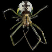
From Stream to Spider: How PFAS Move Through Aquatic and Terrestrial Food Webs
Per- and polyfluoroalkyl substances (PFAS) are persistent synthetic chemicals that accumulate in the environment and living organisms. A USGS study examined how different PFAS compounds move through a stream ecosystem and are transferred from aquatic to terrestrial food webs. The findings documented that not all PFAS behave the same once they enter the environment, leading to differences in...