
Fire and vegetation changes recorded in Alaskan ice cores
The past decade has comprised major fires in central Alaska and Siberia. Fire histories from ice cores in the North Pacific (Denali and the Juneau Icefield) record interactions between changing temperature, precipitation, and biomass burning. We aim to quantify what vegetation burned in the past (hardwoods versus softwoods versus grasses) using ratios of levoglucosan, mannosan and galactosan, and their relationship with a changing climate. We will integrate these results with atmospheric transport models.


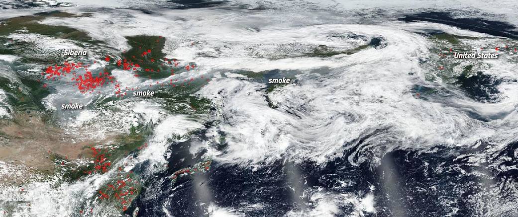
Smoke from Siberian fires traveling towards Alaska. This satellite image was collected by NASA/NOAA Suomi National Polar-orbiting Partnership (S-NPP) on July 29 (U.S. half) and July 30 (Siberian half), 2019. The red points in Siberia and Alaska denote actively burning fires. Image Courtesy: NASA Worldview, Earth Observing System Data and Information System (EOSDIS).

Did we start the fire? Climate, Fire and Humans

Hydroclimate, fire, and human interactions in southwestern US tree ring records

Fire, human activity, and climate records in southwestern US sediments
The past decade has comprised major fires in central Alaska and Siberia. Fire histories from ice cores in the North Pacific (Denali and the Juneau Icefield) record interactions between changing temperature, precipitation, and biomass burning. We aim to quantify what vegetation burned in the past (hardwoods versus softwoods versus grasses) using ratios of levoglucosan, mannosan and galactosan, and their relationship with a changing climate. We will integrate these results with atmospheric transport models.
Smoke from Siberian fires traveling towards Alaska. This satellite image was collected by NASA/NOAA Suomi National Polar-orbiting Partnership (S-NPP) on July 29 (U.S. half) and July 30 (Siberian half), 2019. The red points in Siberia and Alaska denote actively burning fires. Image Courtesy: NASA Worldview, Earth Observing System Data and Information System (EOSDIS).