
Surface Water and Groundwater Availability and Quality in the Prairie Band Potawatomi Nation Reservation
The Prairie Band Potawatomi Nation (PBPN) in Jackson County, Kansas lies within the Big Soldier and Little Soldier Creek basins. The PBPN needs surface and groundwater quality and quantity data for water management purposes and for developing and implementing a water quality program to protect the water of the reservation for the benefit of current and future generations. In January 2020, The U.S. Geological Survey in cooperation with the PBPN began a 5-year study to assess streamflow, groundwater availability, and surface and groundwater quality to characterize drinking water sources for the PBPN. Water-quality constituents of concern (those that exceeded their respective Federal or State criteria) for PBPN water resources include total dissolved solids, sodium, nitrate, total phosphorus, arsenic, boron, iron, pesticides, and indicator bacteria.
OVERVIEW:
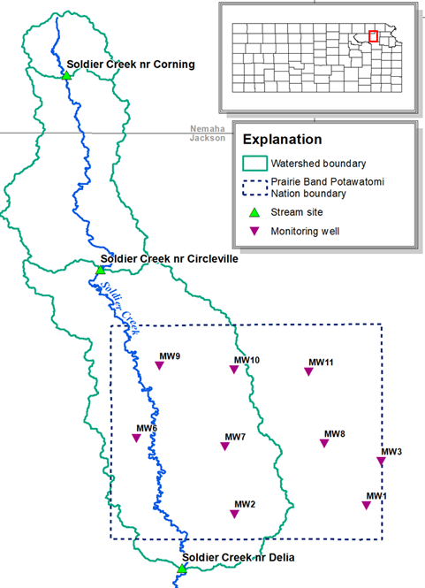
The Prairie Band Potawatomi Nation (PBPN) is in Jackson County, Kansas, and lies within the Big Soldier and Little Soldier Creek basins (Figure 1). The PBPN needs surface-water and groundwater quality and quantity data for water management purposes. The US Geological Survey (USGS), in cooperation with the PBPN, began a study in 2020 to quantify streamflow on Big Soldier Creek, Kansas (the primary stream flowing through the reservation), measure groundwater levels in monitoring wells within the PBPN, and assess water quality in both Big Soldier Creek and groundwater. Streamflow and groundwater-level measurements provide critical information for quantifying water availability. Surface and groundwater quality data allow characterization of drinking water sources for the PBPN. Water-quality constituents of concern (those that exceeded their respective Federal or State criteria) for PBPN water resources include total dissolved solids, sodium, nitrate, total phosphorus, arsenic, boron, iron, pesticides, and indicator bacteria (Mehl and others, 2007). Surface and groundwater-quality monitoring provide the PBPN information to help them reach their water monitoring objectives as part of “developing and implementing a water quality program [that] will assist in protecting the waters…of the reservation for the benefit of current and future generations” (Prairie Band Potawatomi Nation Division of Planning and Environmental Protection, 2018). This study will further establish baseline water-quality conditions for the PBPN and will characterize the study watershed with a water availability assessment.
Science Partnership Opportunity:
The USGS-Prairie Band Potawatomi Nation study and the upstream USGS-KDHE Soldier Creek study will both benefit from the data collected by each study in Soldier Creek. These studies are being conducted at the same time and are sampling and monitoring similar water-quality constituents in Soldier Creek. Although the questions that will be addressed by each study are different, the opportunity to combine the data from both studies will enhance the results for each.
To meet study objectives, the USGS and PBPN are collecting continuous streamflow data at two surface water sites located upstream and downstream from the PBPN Reservation (06889160 Soldier Creek at Circleville [Circleville] and 06889200 Soldier Creek at Delia [Delia]), (fig 1). Water levels are being monitored continuously and reported online in near real-time at one monitoring well (391907095441901 08S 15E 28DDDD01 PBPN MW3 [MW03]; Burns and McDonnell, 2013), measured continuously and recorded at three monitoring wells (391707095445901 09S 15E 09BADC01 PBPN MW1 [MW01], 391948095512201 08S14E 28ABCA01 PBPN MW7 [MW07], and 392315095505801 08S 14E 04AADD01 PBPN MW10 [MW10]), and water levels are being measured manually at five monitoring wells (391644095505601 09S 14E 10CBCC01 PBPN MW2 [MW02], 392010095552301 08S 13E 24CBCC01 PBPN MW6 [MW06], 391955095465301 08S 15E 30ABAB01 PBPN MW8 [MW08], 392325095542101 08S 13E 01AAAB01 PBPN MW9 [MW09], and 392310095473501 08S 14E 01ADAD01 PBPN MW11 [MW11]). The wells are owned by PBPN and well logs are available on the Kansas Geological Survey Water Well Completion Records (WWC5) Database at http://www.kgs.ku.edu/Magellan/WaterWell/. Additionally, the USGS is training PBPN staff for manual groundwater level measurements. Continuous (water temperature, specific conductance, pH, dissolved oxygen, and turbidity) data are recorded at the Circleville surface water site following methods described in Bennett and others (2014) and Wagner and others (2006) and discrete samples are being collected at the Circleville and Delia surface water sites (nutrients, suspended sediment, total suspended solids, and indicator bacteria; sampled approximately monthly) and the nine groundwater monitoring well sites (nutrients and indicator bacteria; sampled yearly). Data will be collected from January 1, 2020 through September 30, 2025.
|
Station |
Next Generation Monitoring Location Page |
|
Soldier Creek near Corning, KS (06889160) |
Soldier Creek NR Corning, KS - USGS Water Data for the Nation |
|
Soldier Creek near Circleville, KS (06889160) |
Soldier C NR Circleville, KS - USGS Water Data for the Nation |
|
Soldier Creek near Delia, KS (06889200) |
|
|
MW01 (391707095445901) |
|
|
MW02 (391644095505601) |
(not yet available on Next Generation Monitoring Location Page) |
|
MW03 (391907095441901) |
|
|
MW06 (392010095552301) |
|
|
MW07 (391948095512201) |
(not yet available on Next Generation Monitoring Location Page) |
|
MW08 (391955095465301) |
(not yet available on Next Generation Monitoring Location Page) |
|
MW09 (392325095542101) |
(not yet available on Next Generation Monitoring Location Page) |
|
MW10 (392315095505801) |
|
|
MW11 (392310095473501) |
(not yet available on Next Generation Monitoring Location Page) |
|
Station |
National Water Information System (Legacy Page) |
|
Soldier Creek near Corning, KS (06889160) |
USGS Current Conditions for USGS 06889110 SOLDIER CREEK NR CORNING, KS |
|
Soldier Creek near Circleville, KS (06889160) |
USGS Current Conditions for USGS 06889160 SOLDIER C NR CIRCLEVILLE, KS |
|
Soldier Creek near Delia, KS (06889200) |
USGS Current Conditions for USGS 06889200 SOLDIER C NR DELIA, KS |
|
MW01 (391707095445901) |
|
|
MW02 (391644095505601) |
|
|
MW03 (391907095441901) |
|
|
MW06 (392010095552301) |
|
|
MW07 (391948095512201) |
|
|
MW08 (391955095465301) |
|
|
MW09 (392325095542101) |
|
|
MW10 (392315095505801) |
|
|
MW11 (392310095473501) |
|
|
Station |
Water Quality Portal URL |
|
Soldier Creek near Corning, KS (06889160) |
https://www.waterqualitydata.us/provider/NWIS/USGS-KS/USGS-06889110/ |
|
Soldier Creek near Circleville, KS (06889160) |
https://www.waterqualitydata.us/provider/NWIS/USGS-KS/USGS-06889160/ |
|
Soldier Creek near Delia, KS (06889200) |
https://www.waterqualitydata.us/provider/NWIS/USGS-KS/USGS-06889200/ |
|
MW01 (391707095445901) |
https://www.waterqualitydata.us/provider/NWIS/USGS-KS/USGS-391707095445901/ |
|
MW02 (391644095505601) |
https://www.waterqualitydata.us/provider/NWIS/USGS-KS/USGS-391644095505601/ |
|
MW03 (391907095441901) |
https://www.waterqualitydata.us/provider/NWIS/USGS-KS/USGS-391907095441901/ |
|
MW06 (392010095552301) |
https://www.waterqualitydata.us/provider/NWIS/USGS-KS/USGS-392010095552301/ |
|
MW07 (391948095512201) |
https://www.waterqualitydata.us/provider/NWIS/USGS-KS/USGS-391948095512201/ |
|
MW08 (391955095465301) |
https://www.waterqualitydata.us/provider/NWIS/USGS-KS/USGS-391955095465301/ |
|
MW09 (392325095542101) |
https://www.waterqualitydata.us/provider/NWIS/USGS-KS/USGS-392325095542101/ |
|
MW10 (392315095505801) |
https://www.waterqualitydata.us/provider/NWIS/USGS-KS/USGS-392315095505801/ |
|
MW11 (392310095473501) |
https://www.waterqualitydata.us/provider/NWIS/USGS-KS/USGS-392310095473501/ |
Approach: The surface water study sites are 06889160 Soldier Creek near Circleville (upstream from the PBPN tribal land) and 06889200 Soldier Creek near Delia (downstream from the PBPN tribal land). The groundwater study sites are PBPN monitoring well sites MW01, MW02, MW03, MW06, MW07, MW08, MW09, MW10, and MW11. All data from the proposed study are available in the USGS National Water Information System (NWIS; https://waterdata.usgs.gov/nwis).
At Delia, an existing USGS streamgage, in operation since October 1990, is collecting streamflow data, in cooperation with the Kansas Water Office. These data are collected at 15-minute intervals and made available in real-time on the internet via NWIS.
Historically, a USGS streamgage was located near Circleville from 1964 through 2001 collecting streamflow and limited discrete water-quality data. A streamgage was reinstalled at the original Circleville streamgage location and is collecting stage data. Streamflow is being measured using standard USGS methods (Sauer and Turnipseed, 2010; Turnipseed and Sauer, 2010), and after a sufficient number of discharge measurements over a wide range of hydrological conditions have been collected, a stage-discharge relationship will be developed in order to compute discharge following Sauer and Turnipseed (2010) and Turnipseed and Sauer (2010). Stage and discharge data, collected at 15-minute intervals, are available in real-time via NWIS.
Precipitation gages were installed at the two surface and one groundwater (MW03) site and operated and maintained following USGS technical memo 2006.01 (water.usgs.gov/admin/memo/SW/OSW_2006-01_Revised_02122010.pdf).
Surface-water resources in the PBPN tribal land will be evaluated using the following methods:
- Selected streamflow metrics described in Olden and Poff (2003) will be calculated from existing data at the two streamgage sites to characterize peak flow, median or mean flow, daily low variability, low and high flow, and base flow. These data will form the basis of the assessment of surface-water availability to the PBPN by providing a quantitative assessment of streamflow at the two surface-water sites above and below the PBPN.
- Comparison of similar flow characteristics from streamgages in basins comparable to Circleville will be used to estimate flows for the period of time from 2001 through 2019 when the streamgage is reinstalled.
Groundwater levels are being measured continuously at the monitoring well MW03 following procedures described in Cunningham and Schalk (2011) and Putnam and Hansen (2014); These data are collected at 15-minute intervals and made available in real-time on the internet via the USGS National Water Information System (NWIS; https://waterdata.usgs.gov/nwis ). Groundwater level recorders measure water levels continuously at three monitoring well sites (MW01, MW07, and MW10) and data is downloaded monthly. Annual manual groundwater level measurements are being made at five PBPN monitoring well sites (MW02, MW03, MW06, MW08, MW09, and MW11). USGS staff are training Potawatomi staff during annual groundwater level measurements to familiarize Potawatomi staff with USGS techniques and methods described in Cunningham and Schalk (2011). Groundwater monitoring stations are being surveyed in using existing benchmarks, if available.
Groundwater resources in the PBPN tribal land will be evaluated using the following methods:
- Continuous groundwater level measurements are being made at four PBPN monitoring well sites. These data are collected at 15-minute intervals and data from one of the sites is available in real-time via NWIS; groundwater levels are recorded at the other three monitoring well sites and downloaded monthly; groundwater levels are measured annually at five sites following Cunningham and Schalk (2011). Groundwater levels will be used to create groundwater level maps.
- Precipitation data collected at surface water sites will be compared to changes in groundwater levels and hydraulic properties of the water-bearing lithology to determine groundwater recharge rates at each monitoring well.
- Groundwater level maps will be developed, if conditions permit, to show the relation of the water table to surface water stage and changes in water table seasonally and in response to recharge.
- Annual groundwater quality samples (nutrients and indicator bacteria) are collected from the nine monitoring wells.
- Groundwater supply studies will be summarized, including the Kansas Geological Survey bulletin on groundwater in Jackson County (Walters, 1953) and the Burns and McDonnell groundwater supply study prepared for the PBPN (2003).
- Well drillers’ logs in the state of Kansas’ Water Well Completion Records Database (Kansas Geological Survey, 2019) will be examined to characterize local lithology.
Surface water/groundwater interactions will be evaluated using base-flow separation analysis of streamflow records and comparison to previous work (Juracek, 2017) to assess the amount of flow between groundwater and streams to provide information on availability of minimum streamflows over time. The conductivity mass balance (CMB) method will be used to perform hydrograph separation at the Circleville site using continuous specific conductivity measurements (Pinder and Jones, 1969; Stewart and others, 2007). Discrete specific conductivity measurements will be used to estimate baseflow at the Delia site (Miller and others, 2015). The CMB method results will be compared with the graphical method used by Juracek (2017).
Surface water sites along Soldier Creek at the Circleville and Delia sites are discretely sampled for nutrients, suspended sediment, total suspended solids, and indicator bacteria. Twelve discrete samples plus two QA/QC samples per site per year are collected approximately monthly across a range of streamflow conditions if possible. Samples are collected following USGS methods described in U.S. Geological Survey (2006) and Rasmussen and others (2014).
Concomitant real-time physicochemical parameters and discretely collected water-quality data will be compared at the Circleville site and, if possible, surrogate relations will be established to continuously compute water-quality constituents of interest in real time following methods described in Rasmussen and others (2008, 2009, and 2016).
All discrete samples are sent to the USGS National Water Quality Laboratory for analysis except for indicator bacteria, which are analyzed by the USGS Kansas Water Science Center field technicians.
Products:
A Scientific Investigations Report and Fact Sheet summarizing of the results of this study will be delivered by September 30, 2025. Presentations and study updates will be provided to PBPN annually and by request. All data from the proposed study will be available in the USGS National Water Information System (NWIS; https://waterdata.usgs.gov/nwis).
References:
Bennett, T.J., Graham, J.L., Foster, G.M., Stone, M.L., Juracek, K.E., Rasmussen, T.J., and Putnam, J.E., 2014, U.S. Geological Survey quality-assurance plan for continuous water-quality monitoring in Kansas, 2014: U.S. Geological Survey Open-File Report 2014–1151, 34 p., https://pubs.usgs.gov/of/2014/1151.
Burns and McDonnell, 2003, Groundwater supply study prepared for the Prairie Band Potawatomi Nation, 70 p.
Cunningham, W.L., and Schalk, C.W., 2011, Groundwater technical procedures of the U.S. Geological Survey: U.S. Geological Survey Techniques and Methods 1–A1, 151 p., https://pubs.usgs.gov/tm/1a1/.
Evenson, E.J., Orndorff, R.C., Blome, C.D., Böhlke, J.K., Hershberger, P.K., Langenheim, V.E., McCabe, G.J., Morlock, S.E., Reeves, H.W., Verdin, J.P., Weyers, H.S., and Wood, T.M., 2013, U.S. Geological Survey water science strategy—Observing, understanding, predicting, and delivering water science to the Nation: U.S. Geological Survey Circular 1383–G, 49 p., https://pubs.er.usgs.gov/publication/cir1383G.
Juracek, K.E., 2017, Streamflow characteristics and trends along Soldier Creek, northeast Kansas: U.S. Geological Survey Scientific Investigations Report 2017–5061, 30 p., https://doi.org/10.3133/sir20175061.
Kansas Geological Survey, 2019, Water well completion records (WWC5) database: Kansas Geological Survey database, accessed August 2019 at http://www.kgs.ku.edu/Magellan/WaterWell/.
Mehl, H.E., Schmidt, H.C. Ross, and Pope, L.M., 2007, Water quality on the Prairie Band Potawatomi Reservation, northeastern Kansas, June 1996 through August 2006: U.S. Geological Survey Scientific Investigations Report 2007–5201, 75 p., https://pubs.er.usgs.gov/publication/sir20075201.
Miller, M.P., Johnson, H.M., Susong, D.D., and Wolock, D.M., 2015, A new approach for continuous estimation of baseflow using discrete water quality data: method description and comparison with baseflow estimates from two existing approaches: Journal of Hydrology, v. 522, p. 203–210, https://doi.org/10.1016/j.jhydrol.2014.12.039.
Olden, J.D., and Poff, N.L., 2003, Redundancy and the choice of hydrologic indices for characterizing streamflow regimes: River Research and Applications, v. 19, no. 2, p. 101–121, https://doi.org/10.1002/rra.700.
Pinder, G.F., and Jones, J.F., 1969, Determination of the groundwater component of peak discharge from chemistry of total runoff: Water Resources Research, v. 5, no. 2, p. 438–445, https://doi.org/10.1029/WR005i002p00438.
Putnam, J.E., and Hansen, C.V., 2014, Quality-assurance and data management plan for groundwater activities by the U.S. Geological Survey in Kansas, 2014: U.S. Geological Survey Open-File Report 2014–1060, 37 p., https://pubs.usgs.gov/of/2014/1060.
Rasmussen, P.P., Gray, J.R., Glysson, G.D., and Ziegler, A.C., 2009, Guidelines and procedures for computing time-series suspended-sediment concentrations and loads from in-stream turbidity-sensor and streamflow data: U.S. Geological Survey Techniques and Methods, book 3, chap. C4, 52 p., https://pubs.usgs.gov/tm/tm3c4/.
Rasmussen, P.P, Eslick, P.J., and Ziegler, A.C., 2016, Relations between continuous real-time physical properties and discrete water-quality constituents in the Little Arkansas River, south-central Kansas, 1998–2014: U.S. Geological Survey Open-File Report 2016–1057, 16 p., https://pubs.er.usgs.gov/publication/ofr20161057.
Rasmussen, T.J., Bennett, T.J., Stone, M.L., Foster, G.M., Graham, J.L., and Putnam, J.E., 2014, Quality-assurance and data-management plan for water-quality activities in the Kansas Water Science Center, 2014: U.S. Geological Survey Open-File Report 2014–1233, 41 p., https://pubs.usgs.gov/of/2014/1233/.
Rasmussen, T.J., Lee, C.J., and Ziegler, A.C., 2008, Estimation of constituent concentrations, loads, and yields in streams of Johnson County, northeast Kansas, using continuous water-quality monitoring and regression models, October 2002 through December 2006: U.S. Geological Survey Scientific Investigations Report 2008–5014, 103 p., https://pubs.usgs.gov/sir/2008/5014.
Sauer , V.B., and Turnipseed, D.P., 2010, Stage measurement at gaging stations: U.S. Geological Survey Techniques and Methods, book 3, chap. A7, 45 p., https://pubs.usgs.gov/tm/tm3-a7/.
Stewart, M., Cimino, J., and Ross, M., 2007, Calibration of baseflow separation methods with streamflow conductivity: Ground Water, v. 45, p. 17–27, https://doi.org/10.1111/j.1745-6584.2006.00263.x.
Turnipseed, D.P., and Sauer, V.B., 2010, Discharge measurements at gaging stations: U.S. Geological Survey Techniques and Methods, book 3, chap. A8, 87 p., https://pubs.usgs.gov/tm/tm3-a8/.
U.S. Geological Survey, 2006, Collection of water samples (ver. 2.0): U.S. Geological Survey Techniques of Water-Resources Investigations, book 9, chap. A4, 231 p., https://pubs.water.usgs.gov/twri9A4/.
Wagner, R.J., Boulger, R.W., Jr., Oblinger, C.J., and Smith, B.A., 2006, Guidelines and standard procedures for continuous water-quality monitors—Station operation, record computation, and data reporting: U.S. Geological Survey Techniques and Methods, book 1, chap. D3, 96 p., https://pubs.usgs.gov/tm/2006/tm1D3.
Walters, K.L., 1953, Geology and ground-water resources of Jackson County, Kansas: Kansas Geological Survey Bulletin 101, http://www.kgs.ku.edu/General/Geology/Jackson/index.html, accessed August 13, 2019.
The Prairie Band Potawatomi Nation (PBPN) in Jackson County, Kansas lies within the Big Soldier and Little Soldier Creek basins. The PBPN needs surface and groundwater quality and quantity data for water management purposes and for developing and implementing a water quality program to protect the water of the reservation for the benefit of current and future generations. In January 2020, The U.S. Geological Survey in cooperation with the PBPN began a 5-year study to assess streamflow, groundwater availability, and surface and groundwater quality to characterize drinking water sources for the PBPN. Water-quality constituents of concern (those that exceeded their respective Federal or State criteria) for PBPN water resources include total dissolved solids, sodium, nitrate, total phosphorus, arsenic, boron, iron, pesticides, and indicator bacteria.
OVERVIEW:
The Prairie Band Potawatomi Nation (PBPN) is in Jackson County, Kansas, and lies within the Big Soldier and Little Soldier Creek basins (Figure 1). The PBPN needs surface-water and groundwater quality and quantity data for water management purposes. The US Geological Survey (USGS), in cooperation with the PBPN, began a study in 2020 to quantify streamflow on Big Soldier Creek, Kansas (the primary stream flowing through the reservation), measure groundwater levels in monitoring wells within the PBPN, and assess water quality in both Big Soldier Creek and groundwater. Streamflow and groundwater-level measurements provide critical information for quantifying water availability. Surface and groundwater quality data allow characterization of drinking water sources for the PBPN. Water-quality constituents of concern (those that exceeded their respective Federal or State criteria) for PBPN water resources include total dissolved solids, sodium, nitrate, total phosphorus, arsenic, boron, iron, pesticides, and indicator bacteria (Mehl and others, 2007). Surface and groundwater-quality monitoring provide the PBPN information to help them reach their water monitoring objectives as part of “developing and implementing a water quality program [that] will assist in protecting the waters…of the reservation for the benefit of current and future generations” (Prairie Band Potawatomi Nation Division of Planning and Environmental Protection, 2018). This study will further establish baseline water-quality conditions for the PBPN and will characterize the study watershed with a water availability assessment.
Science Partnership Opportunity:
The USGS-Prairie Band Potawatomi Nation study and the upstream USGS-KDHE Soldier Creek study will both benefit from the data collected by each study in Soldier Creek. These studies are being conducted at the same time and are sampling and monitoring similar water-quality constituents in Soldier Creek. Although the questions that will be addressed by each study are different, the opportunity to combine the data from both studies will enhance the results for each.
To meet study objectives, the USGS and PBPN are collecting continuous streamflow data at two surface water sites located upstream and downstream from the PBPN Reservation (06889160 Soldier Creek at Circleville [Circleville] and 06889200 Soldier Creek at Delia [Delia]), (fig 1). Water levels are being monitored continuously and reported online in near real-time at one monitoring well (391907095441901 08S 15E 28DDDD01 PBPN MW3 [MW03]; Burns and McDonnell, 2013), measured continuously and recorded at three monitoring wells (391707095445901 09S 15E 09BADC01 PBPN MW1 [MW01], 391948095512201 08S14E 28ABCA01 PBPN MW7 [MW07], and 392315095505801 08S 14E 04AADD01 PBPN MW10 [MW10]), and water levels are being measured manually at five monitoring wells (391644095505601 09S 14E 10CBCC01 PBPN MW2 [MW02], 392010095552301 08S 13E 24CBCC01 PBPN MW6 [MW06], 391955095465301 08S 15E 30ABAB01 PBPN MW8 [MW08], 392325095542101 08S 13E 01AAAB01 PBPN MW9 [MW09], and 392310095473501 08S 14E 01ADAD01 PBPN MW11 [MW11]). The wells are owned by PBPN and well logs are available on the Kansas Geological Survey Water Well Completion Records (WWC5) Database at http://www.kgs.ku.edu/Magellan/WaterWell/. Additionally, the USGS is training PBPN staff for manual groundwater level measurements. Continuous (water temperature, specific conductance, pH, dissolved oxygen, and turbidity) data are recorded at the Circleville surface water site following methods described in Bennett and others (2014) and Wagner and others (2006) and discrete samples are being collected at the Circleville and Delia surface water sites (nutrients, suspended sediment, total suspended solids, and indicator bacteria; sampled approximately monthly) and the nine groundwater monitoring well sites (nutrients and indicator bacteria; sampled yearly). Data will be collected from January 1, 2020 through September 30, 2025.
|
Station |
Next Generation Monitoring Location Page |
|
Soldier Creek near Corning, KS (06889160) |
Soldier Creek NR Corning, KS - USGS Water Data for the Nation |
|
Soldier Creek near Circleville, KS (06889160) |
Soldier C NR Circleville, KS - USGS Water Data for the Nation |
|
Soldier Creek near Delia, KS (06889200) |
|
|
MW01 (391707095445901) |
|
|
MW02 (391644095505601) |
(not yet available on Next Generation Monitoring Location Page) |
|
MW03 (391907095441901) |
|
|
MW06 (392010095552301) |
|
|
MW07 (391948095512201) |
(not yet available on Next Generation Monitoring Location Page) |
|
MW08 (391955095465301) |
(not yet available on Next Generation Monitoring Location Page) |
|
MW09 (392325095542101) |
(not yet available on Next Generation Monitoring Location Page) |
|
MW10 (392315095505801) |
|
|
MW11 (392310095473501) |
(not yet available on Next Generation Monitoring Location Page) |
|
Station |
National Water Information System (Legacy Page) |
|
Soldier Creek near Corning, KS (06889160) |
USGS Current Conditions for USGS 06889110 SOLDIER CREEK NR CORNING, KS |
|
Soldier Creek near Circleville, KS (06889160) |
USGS Current Conditions for USGS 06889160 SOLDIER C NR CIRCLEVILLE, KS |
|
Soldier Creek near Delia, KS (06889200) |
USGS Current Conditions for USGS 06889200 SOLDIER C NR DELIA, KS |
|
MW01 (391707095445901) |
|
|
MW02 (391644095505601) |
|
|
MW03 (391907095441901) |
|
|
MW06 (392010095552301) |
|
|
MW07 (391948095512201) |
|
|
MW08 (391955095465301) |
|
|
MW09 (392325095542101) |
|
|
MW10 (392315095505801) |
|
|
MW11 (392310095473501) |
|
|
Station |
Water Quality Portal URL |
|
Soldier Creek near Corning, KS (06889160) |
https://www.waterqualitydata.us/provider/NWIS/USGS-KS/USGS-06889110/ |
|
Soldier Creek near Circleville, KS (06889160) |
https://www.waterqualitydata.us/provider/NWIS/USGS-KS/USGS-06889160/ |
|
Soldier Creek near Delia, KS (06889200) |
https://www.waterqualitydata.us/provider/NWIS/USGS-KS/USGS-06889200/ |
|
MW01 (391707095445901) |
https://www.waterqualitydata.us/provider/NWIS/USGS-KS/USGS-391707095445901/ |
|
MW02 (391644095505601) |
https://www.waterqualitydata.us/provider/NWIS/USGS-KS/USGS-391644095505601/ |
|
MW03 (391907095441901) |
https://www.waterqualitydata.us/provider/NWIS/USGS-KS/USGS-391907095441901/ |
|
MW06 (392010095552301) |
https://www.waterqualitydata.us/provider/NWIS/USGS-KS/USGS-392010095552301/ |
|
MW07 (391948095512201) |
https://www.waterqualitydata.us/provider/NWIS/USGS-KS/USGS-391948095512201/ |
|
MW08 (391955095465301) |
https://www.waterqualitydata.us/provider/NWIS/USGS-KS/USGS-391955095465301/ |
|
MW09 (392325095542101) |
https://www.waterqualitydata.us/provider/NWIS/USGS-KS/USGS-392325095542101/ |
|
MW10 (392315095505801) |
https://www.waterqualitydata.us/provider/NWIS/USGS-KS/USGS-392315095505801/ |
|
MW11 (392310095473501) |
https://www.waterqualitydata.us/provider/NWIS/USGS-KS/USGS-392310095473501/ |
Approach: The surface water study sites are 06889160 Soldier Creek near Circleville (upstream from the PBPN tribal land) and 06889200 Soldier Creek near Delia (downstream from the PBPN tribal land). The groundwater study sites are PBPN monitoring well sites MW01, MW02, MW03, MW06, MW07, MW08, MW09, MW10, and MW11. All data from the proposed study are available in the USGS National Water Information System (NWIS; https://waterdata.usgs.gov/nwis).
At Delia, an existing USGS streamgage, in operation since October 1990, is collecting streamflow data, in cooperation with the Kansas Water Office. These data are collected at 15-minute intervals and made available in real-time on the internet via NWIS.
Historically, a USGS streamgage was located near Circleville from 1964 through 2001 collecting streamflow and limited discrete water-quality data. A streamgage was reinstalled at the original Circleville streamgage location and is collecting stage data. Streamflow is being measured using standard USGS methods (Sauer and Turnipseed, 2010; Turnipseed and Sauer, 2010), and after a sufficient number of discharge measurements over a wide range of hydrological conditions have been collected, a stage-discharge relationship will be developed in order to compute discharge following Sauer and Turnipseed (2010) and Turnipseed and Sauer (2010). Stage and discharge data, collected at 15-minute intervals, are available in real-time via NWIS.
Precipitation gages were installed at the two surface and one groundwater (MW03) site and operated and maintained following USGS technical memo 2006.01 (water.usgs.gov/admin/memo/SW/OSW_2006-01_Revised_02122010.pdf).
Surface-water resources in the PBPN tribal land will be evaluated using the following methods:
- Selected streamflow metrics described in Olden and Poff (2003) will be calculated from existing data at the two streamgage sites to characterize peak flow, median or mean flow, daily low variability, low and high flow, and base flow. These data will form the basis of the assessment of surface-water availability to the PBPN by providing a quantitative assessment of streamflow at the two surface-water sites above and below the PBPN.
- Comparison of similar flow characteristics from streamgages in basins comparable to Circleville will be used to estimate flows for the period of time from 2001 through 2019 when the streamgage is reinstalled.
Groundwater levels are being measured continuously at the monitoring well MW03 following procedures described in Cunningham and Schalk (2011) and Putnam and Hansen (2014); These data are collected at 15-minute intervals and made available in real-time on the internet via the USGS National Water Information System (NWIS; https://waterdata.usgs.gov/nwis ). Groundwater level recorders measure water levels continuously at three monitoring well sites (MW01, MW07, and MW10) and data is downloaded monthly. Annual manual groundwater level measurements are being made at five PBPN monitoring well sites (MW02, MW03, MW06, MW08, MW09, and MW11). USGS staff are training Potawatomi staff during annual groundwater level measurements to familiarize Potawatomi staff with USGS techniques and methods described in Cunningham and Schalk (2011). Groundwater monitoring stations are being surveyed in using existing benchmarks, if available.
Groundwater resources in the PBPN tribal land will be evaluated using the following methods:
- Continuous groundwater level measurements are being made at four PBPN monitoring well sites. These data are collected at 15-minute intervals and data from one of the sites is available in real-time via NWIS; groundwater levels are recorded at the other three monitoring well sites and downloaded monthly; groundwater levels are measured annually at five sites following Cunningham and Schalk (2011). Groundwater levels will be used to create groundwater level maps.
- Precipitation data collected at surface water sites will be compared to changes in groundwater levels and hydraulic properties of the water-bearing lithology to determine groundwater recharge rates at each monitoring well.
- Groundwater level maps will be developed, if conditions permit, to show the relation of the water table to surface water stage and changes in water table seasonally and in response to recharge.
- Annual groundwater quality samples (nutrients and indicator bacteria) are collected from the nine monitoring wells.
- Groundwater supply studies will be summarized, including the Kansas Geological Survey bulletin on groundwater in Jackson County (Walters, 1953) and the Burns and McDonnell groundwater supply study prepared for the PBPN (2003).
- Well drillers’ logs in the state of Kansas’ Water Well Completion Records Database (Kansas Geological Survey, 2019) will be examined to characterize local lithology.
Surface water/groundwater interactions will be evaluated using base-flow separation analysis of streamflow records and comparison to previous work (Juracek, 2017) to assess the amount of flow between groundwater and streams to provide information on availability of minimum streamflows over time. The conductivity mass balance (CMB) method will be used to perform hydrograph separation at the Circleville site using continuous specific conductivity measurements (Pinder and Jones, 1969; Stewart and others, 2007). Discrete specific conductivity measurements will be used to estimate baseflow at the Delia site (Miller and others, 2015). The CMB method results will be compared with the graphical method used by Juracek (2017).
Surface water sites along Soldier Creek at the Circleville and Delia sites are discretely sampled for nutrients, suspended sediment, total suspended solids, and indicator bacteria. Twelve discrete samples plus two QA/QC samples per site per year are collected approximately monthly across a range of streamflow conditions if possible. Samples are collected following USGS methods described in U.S. Geological Survey (2006) and Rasmussen and others (2014).
Concomitant real-time physicochemical parameters and discretely collected water-quality data will be compared at the Circleville site and, if possible, surrogate relations will be established to continuously compute water-quality constituents of interest in real time following methods described in Rasmussen and others (2008, 2009, and 2016).
All discrete samples are sent to the USGS National Water Quality Laboratory for analysis except for indicator bacteria, which are analyzed by the USGS Kansas Water Science Center field technicians.
Products:
A Scientific Investigations Report and Fact Sheet summarizing of the results of this study will be delivered by September 30, 2025. Presentations and study updates will be provided to PBPN annually and by request. All data from the proposed study will be available in the USGS National Water Information System (NWIS; https://waterdata.usgs.gov/nwis).
References:
Bennett, T.J., Graham, J.L., Foster, G.M., Stone, M.L., Juracek, K.E., Rasmussen, T.J., and Putnam, J.E., 2014, U.S. Geological Survey quality-assurance plan for continuous water-quality monitoring in Kansas, 2014: U.S. Geological Survey Open-File Report 2014–1151, 34 p., https://pubs.usgs.gov/of/2014/1151.
Burns and McDonnell, 2003, Groundwater supply study prepared for the Prairie Band Potawatomi Nation, 70 p.
Cunningham, W.L., and Schalk, C.W., 2011, Groundwater technical procedures of the U.S. Geological Survey: U.S. Geological Survey Techniques and Methods 1–A1, 151 p., https://pubs.usgs.gov/tm/1a1/.
Evenson, E.J., Orndorff, R.C., Blome, C.D., Böhlke, J.K., Hershberger, P.K., Langenheim, V.E., McCabe, G.J., Morlock, S.E., Reeves, H.W., Verdin, J.P., Weyers, H.S., and Wood, T.M., 2013, U.S. Geological Survey water science strategy—Observing, understanding, predicting, and delivering water science to the Nation: U.S. Geological Survey Circular 1383–G, 49 p., https://pubs.er.usgs.gov/publication/cir1383G.
Juracek, K.E., 2017, Streamflow characteristics and trends along Soldier Creek, northeast Kansas: U.S. Geological Survey Scientific Investigations Report 2017–5061, 30 p., https://doi.org/10.3133/sir20175061.
Kansas Geological Survey, 2019, Water well completion records (WWC5) database: Kansas Geological Survey database, accessed August 2019 at http://www.kgs.ku.edu/Magellan/WaterWell/.
Mehl, H.E., Schmidt, H.C. Ross, and Pope, L.M., 2007, Water quality on the Prairie Band Potawatomi Reservation, northeastern Kansas, June 1996 through August 2006: U.S. Geological Survey Scientific Investigations Report 2007–5201, 75 p., https://pubs.er.usgs.gov/publication/sir20075201.
Miller, M.P., Johnson, H.M., Susong, D.D., and Wolock, D.M., 2015, A new approach for continuous estimation of baseflow using discrete water quality data: method description and comparison with baseflow estimates from two existing approaches: Journal of Hydrology, v. 522, p. 203–210, https://doi.org/10.1016/j.jhydrol.2014.12.039.
Olden, J.D., and Poff, N.L., 2003, Redundancy and the choice of hydrologic indices for characterizing streamflow regimes: River Research and Applications, v. 19, no. 2, p. 101–121, https://doi.org/10.1002/rra.700.
Pinder, G.F., and Jones, J.F., 1969, Determination of the groundwater component of peak discharge from chemistry of total runoff: Water Resources Research, v. 5, no. 2, p. 438–445, https://doi.org/10.1029/WR005i002p00438.
Putnam, J.E., and Hansen, C.V., 2014, Quality-assurance and data management plan for groundwater activities by the U.S. Geological Survey in Kansas, 2014: U.S. Geological Survey Open-File Report 2014–1060, 37 p., https://pubs.usgs.gov/of/2014/1060.
Rasmussen, P.P., Gray, J.R., Glysson, G.D., and Ziegler, A.C., 2009, Guidelines and procedures for computing time-series suspended-sediment concentrations and loads from in-stream turbidity-sensor and streamflow data: U.S. Geological Survey Techniques and Methods, book 3, chap. C4, 52 p., https://pubs.usgs.gov/tm/tm3c4/.
Rasmussen, P.P, Eslick, P.J., and Ziegler, A.C., 2016, Relations between continuous real-time physical properties and discrete water-quality constituents in the Little Arkansas River, south-central Kansas, 1998–2014: U.S. Geological Survey Open-File Report 2016–1057, 16 p., https://pubs.er.usgs.gov/publication/ofr20161057.
Rasmussen, T.J., Bennett, T.J., Stone, M.L., Foster, G.M., Graham, J.L., and Putnam, J.E., 2014, Quality-assurance and data-management plan for water-quality activities in the Kansas Water Science Center, 2014: U.S. Geological Survey Open-File Report 2014–1233, 41 p., https://pubs.usgs.gov/of/2014/1233/.
Rasmussen, T.J., Lee, C.J., and Ziegler, A.C., 2008, Estimation of constituent concentrations, loads, and yields in streams of Johnson County, northeast Kansas, using continuous water-quality monitoring and regression models, October 2002 through December 2006: U.S. Geological Survey Scientific Investigations Report 2008–5014, 103 p., https://pubs.usgs.gov/sir/2008/5014.
Sauer , V.B., and Turnipseed, D.P., 2010, Stage measurement at gaging stations: U.S. Geological Survey Techniques and Methods, book 3, chap. A7, 45 p., https://pubs.usgs.gov/tm/tm3-a7/.
Stewart, M., Cimino, J., and Ross, M., 2007, Calibration of baseflow separation methods with streamflow conductivity: Ground Water, v. 45, p. 17–27, https://doi.org/10.1111/j.1745-6584.2006.00263.x.
Turnipseed, D.P., and Sauer, V.B., 2010, Discharge measurements at gaging stations: U.S. Geological Survey Techniques and Methods, book 3, chap. A8, 87 p., https://pubs.usgs.gov/tm/tm3-a8/.
U.S. Geological Survey, 2006, Collection of water samples (ver. 2.0): U.S. Geological Survey Techniques of Water-Resources Investigations, book 9, chap. A4, 231 p., https://pubs.water.usgs.gov/twri9A4/.
Wagner, R.J., Boulger, R.W., Jr., Oblinger, C.J., and Smith, B.A., 2006, Guidelines and standard procedures for continuous water-quality monitors—Station operation, record computation, and data reporting: U.S. Geological Survey Techniques and Methods, book 1, chap. D3, 96 p., https://pubs.usgs.gov/tm/2006/tm1D3.
Walters, K.L., 1953, Geology and ground-water resources of Jackson County, Kansas: Kansas Geological Survey Bulletin 101, http://www.kgs.ku.edu/General/Geology/Jackson/index.html, accessed August 13, 2019.