
New England Water Science Center Projects
The New England Water Science Center monitors, analyzes, and communicates information on the quality and movement of surface water and groundwater within the states of Connecticut, Maine, Massachusetts, New Hampshire, Rhode Island, and Vermont.
Explore our projects to learn more about the scientific investigations we conduct. Use keywords and the available filters to narrow your search scope.
Explore Our Projects
Explore Our Projects
Filter Total Items: 92

Estimation of Daily Streamflow and Water Availability in the Massachusetts Sustainable-Yield Estimator, Version 2.0
The Massachusetts Sustainable-Yield Estimator is a decision-support tool that provides estimates of daily unaltered streamflow, water-use-adjusted streamflow, and water availability for ungaged, user-defined sites in Massachusetts. In this recently completed study, version 2.0 of the original Sustainable-Yield Estimator (Archfield and others, 2010) was developed with minor changes to the...

The Purge Analyzer Tool (PAT) to Assess Optimal Pumping Parameters in the Collection of Representative Groundwater Samples from Wells
The U.S. Geological Survey in cooperation with the U.S. Environmental Protection Agency is developing analytical models to assess in-well groundwater flow conditions during the collection of groundwater samples from wells being pumped. This information can be used to inform groundwater samplers on when and how to collect samples that are most reflective of the targeted aquifer or hydrogeologiic...

Assessment of Hydrologic and Water-Quality Changes in Shallow Groundwater Beneath a Coastal Neighborhood Being Converted from Septic Systems to Municipal Sewers
The U.S. Geological Survey and the U.S. Environmental Protection Agency are collaborating on a study to better understand changes to groundwater quality beneath a densely developed coastal neighborhood as it undergoes conversion from onsite wastewater disposal to municipal sewering.

Geospatial Dataset of Wells and Attributes in the New England Groundwater Level Network, 2017
The drought of 2016 affected hydrologic conditions throughout New England. Responses of USGS groundwater observation wells to this event, however, were not uniform and were sometimes markedly different from site to site. Although USGS scientists were able to provide explanations for most of these situations, the event highlighted the need for additional well information to develop quantitative and...

Groundwater and Surface-Water Monitoring in the Mill Creek Watershed, Wellfleet and Truro, Massachusetts
The Herring River estuary and salt marsh system, within the Cape Cod National Seashore in Wellfleet, Massachusetts, has been diked off from the ocean for more than 100 years. The National Park Service is now preparing to restore the 1,100 acre estuary-marsh system.

Nutrient and Sediment Load Reduction Estimates from Intensive Street Cleaning and Leaf Litter Removal Practices in Vermont
Urban stormwater runoff contains high phosphorus concentrations that contribute to the eutrophication to receiving waters. Recent studies have further shown that leaf fall management presents an opportunity to maximize the effectiveness of common municipal practices such as street cleaning and leaf litter removal and substantially nutrient loading.

Characterization of Water Quality in the Sakonnet River, Rhode Island, 2018-19
Sections of Narragansett Bay and its eastern arm, the Sakonnet River, are considered impaired for shellfishing, aquatic habitat and recreational use by the State of Rhode Island. Aquatic habitat and water quality in the western portions of Narragansett Bay are relatively well understood, but there is comparably limited information available in the Sakonnet River. To address concerns about the lack...

Surface Water Quality Monitoring in Rhode Island
Since 1979, the USGS has monitored water quality in the major river basins of Rhode Island contributing to Narragansett Bay.
Surface Water Quality Monitoring in Connecticut
The 2,983 miles of streams in Connecticut support a range of uses, including drinking water, recreation, and fish and shellfish habitat. The State is required by the Clean Water Act to assess the health of these waters every two years.

Updating a Method to Estimate Probable High Groundwater Levels in Massachusetts
Periodic high groundwater levels are a major cause of septic system-failures, wet basements, and other problems for suburban and rural residents in Massachusetts. To address this issue, a method (commonly referred to as the Frimpter method) was developed in early 1980’s to estimate probable high groundwater levels across the state. The USGS New England Water Science Center, in cooperation with the...
Preliminary Research into the Causes of Iron Fouling in Water at Roadway Construction Sites
The USGS and the New Hampshire Department of Transportation are conducting preliminary research into the causes of iron fouling in water at roadway construction sites where blasted bedrock is used as on-site fill material.

Study to Test a Novel Shallow Well Design that May Provide Contaminant-Free Water Supply to Domestic Well Users in Arsenic-Prone Parts of the United States
The USGS, the University of New Hampshire, U.S. Environmental Protection Agency, the New Hampshire Department of Environmental Services, and the Maine Geological Survey are collaborating on a study of a novel shallow well design that might be able to provide safe drinking water to domestic well users in arsenic-prone parts of the Nation.

Towards Understanding the Impact of Drought on the Arsenic Hazard for the Private Domestic Well Population in the United States
The USGS and the Centers for Disease Control and Prevention are examining the potential effects of droughts on the arsenic hazard in private well water across the Nation.

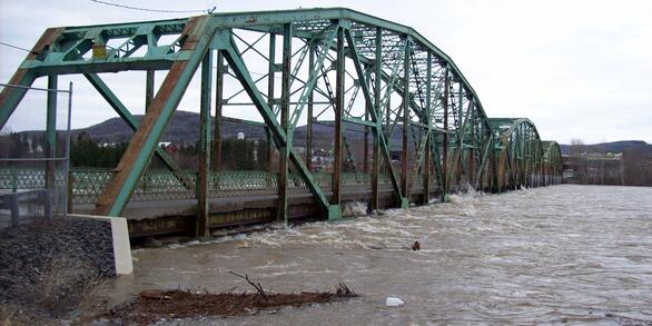
Development of Flood Insurance Maps in New England
FEMA has requested USGS expertise in hydraulics, hydrology, and mapping to generate flood insurance maps for New England.

Development of Streamflow Record Extension Equations in New Hampshire
Currently, there are 16 designated rivers in New Hampshire in need of daily mean streamflow estimates for managing instream flows. Many of New Hampshire’s Designated Rivers have current and/or historical streamflow data that may be used to extend an existing streamgages streamflow record in time through record extension techniques. Evaluating the feasibility of record extension techniques to...

Flow Modeling at Dam Removal Sites Associated with Hurricane Sandy Resiliency Efforts
The purpose of this work is to better understand the effects of dam removal on local hydraulics, fish passage, and flooding. This study is part of a larger effort to monitor ecological resilience changes at nine Hurricane Sandy coastal resiliency aquatic connectivity restoration projects. It will contribute crucial knowledge that will be used to improve aquatic connectivity system cost...

The Influence of Climatic changes on Extreme Streamflows in the United States
Hydrologic droughts and floods can have severe impacts on river infrastructure, water supply, and ecosystem functioning.

Development of Regional Regression Equations to Estimate the Magnitude of Peak Flows for Selected Annual-Exceedance Probabilities in Maine
The flood-frequency characteristics for streamgages and regression equations for estimating flood magnitudes have been published.

Trend Reproduction
As part of the National Water Budget Project, our objective is to quantify how well observed trends are simulated.

HBMI PRMS Project
This project will provide a deterministic watershed model of the Meduxnekeag River watershed with a capacity to model water-temperatures capable of simulating future hydrologic and temperature changes based on projected climate estimates.

EPA National Low Flows
Low streamflow has great ecological importance as it defines the minimum extent (and carrying capacity) of in-stream habitat and affects biota composition and distribution, and species trophic structure.