


Boston University Professor Curtis Woodcock talks about the significance Landsat was had in science and what he hopes to see as the mission continues.
Are there any restrictions on the use or redistribution of Landsat data?
There are no restrictions on Landsat data downloaded from the USGS; it can be used or redistributed as desired. We do request that you include a statement of the data source when citing, copying, or reprinting USGS Landsat data or images.
Details are on the EROS Data Citation page.
Learn more: USGS Copyrights and Credits statement
Related
How do I open Landsat satellite data files?
Many image processing programs can handle GeoTIFF and Cloud optimized GeoTIFF (COG) Landsat files, including free software like Multispec and QGIS. To view Landsat scenes without using specialized software, download Landsat Full Resolution browse images (.jpg) from EarthExplorer or GloVis. * The USGS does NOT endorse or support specific software packages. Any usability questions relating to...
What is the Landsat satellite program and why is it important?
The Landsat Program is a series of Earth-observing satellite missions jointly managed by NASA and the U.S. Geological Survey. On July 23, 1972, in cooperation with NASA, the Earth Resources Technology Satellite (ERTS-1) was launched. It was later renamed Landsat 1. Additional Landsat satellites have launched to bring the world an archive of remote sensing data. Currently orbiting and active...
Can Landsat satellite acquisition requests be made for a specific date and location?
The Landsat 8 and Landsat 9 satellites together acquire approximately 1,500 scenes daily. These scenes are available for download within 6 hours of acquisition. Landsat satellite acquisitions are managed as a system, known as a satellite constellation. Long-Term Acquisition Plans (LTAPs) direct and optimize the daily acquisitions of each active Landsat satellite. Special requests for future...
What are Landsat Collections?
In 2016, the USGS reorganized the Landsat archive into a tiered collection. This structure ensures that Landsat Level-1 products provide a consistent archive of known data quality to support time-series analyses and data “stacking”, while controlling continuous improvement of the archive and access to all data as they are acquired. Learn more: Landsat Collections Landsat Data Access
Can Landsat Collection Real-Time scenes be used in my research?
Landsat Collections Real-Time (RT) data is provided within 12 hours of acquisition in support of the International Charter to help mitigate the effects of disasters on human life and property. The RT tier contains data received from Landsat 8 immediately after acquisition. Estimated radiometric and geometric calibration parameters are applied to these scenes. When final radiometric and geometric...
What are the best Landsat spectral bands for use in my research?
The Spectral Characteristics Viewer is an interactive tool that can be used to visualize how the bands, or channels, of different satellite sensors measure the intensity of the many wavelengths (colors) of light. This is also known as the relative spectral response (RSR). By overlaying the spectral curves from different features (spectra), one can determine which bands of the selected sensor will...
How do I search for and download Landsat data?
Landsat data products held in the USGS archives can be searched and downloaded at no charge from a variety of sources. Visit Landsat Data Access for information about how Landsat data products can be downloaded individually or in bulk. Landsat imagery not found in the USGS archive might have been collected by one of the USGS International Cooperator ground stations, each of which are the primary...

Landsat in Action - The Importance of Landsat with Curtis Woodcock
Boston University Professor Curtis Woodcock talks about the significance Landsat was had in science and what he hopes to see as the mission continues.

Landsat in Action - Free & Open Landsat Archive with Barbara Ryan
Barbara Ryan, Director of GEO talks about the distribution of Landsat data, starting in 1972, and ultimately transitioning to the free and open policy of today.
Barbara Ryan, Director of GEO talks about the distribution of Landsat data, starting in 1972, and ultimately transitioning to the free and open policy of today.

Landsat Collections
Landsat Collections: Providing a Stable Environmental Record for Time Series Analysis
Landsat Collections: Providing a Stable Environmental Record for Time Series Analysis

Landsat in Action — Open Data in Australia with Adam Lewis
Geoscience Australia's Acting Chief Scientist Adam Lewis talks about the value of Landsat data, the importance of free and open policy, and how analysis ready data is advancing earth observing science.
Geoscience Australia's Acting Chief Scientist Adam Lewis talks about the value of Landsat data, the importance of free and open policy, and how analysis ready data is advancing earth observing science.

Landsat Collections — What are Tiers?
This is the third video in a series describing the new U.S. Geological Survey (USGS) Landsat Collection 1 inventory structure. Collection 1 required the reprocessing of all archived Landsat data to achieve radiometric and geometric consistency of Level-1 products through time and across all Landsat sensors.
This is the third video in a series describing the new U.S. Geological Survey (USGS) Landsat Collection 1 inventory structure. Collection 1 required the reprocessing of all archived Landsat data to achieve radiometric and geometric consistency of Level-1 products through time and across all Landsat sensors.
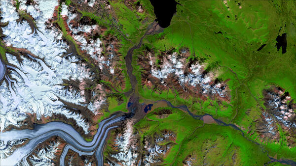
Landsat 8 image of Kaskawulsh Glacier in Canada's Yukon Territory
Landsat 8 satellite image of the Kaskawulsh Glacier in Canada's Yukon Territory, showing how glacier melt has altered meltwater discharge to the Kaskawulsh River.
Landsat 8 satellite image of the Kaskawulsh Glacier in Canada's Yukon Territory, showing how glacier melt has altered meltwater discharge to the Kaskawulsh River.
Related
How do I open Landsat satellite data files?
Many image processing programs can handle GeoTIFF and Cloud optimized GeoTIFF (COG) Landsat files, including free software like Multispec and QGIS. To view Landsat scenes without using specialized software, download Landsat Full Resolution browse images (.jpg) from EarthExplorer or GloVis. * The USGS does NOT endorse or support specific software packages. Any usability questions relating to...
What is the Landsat satellite program and why is it important?
The Landsat Program is a series of Earth-observing satellite missions jointly managed by NASA and the U.S. Geological Survey. On July 23, 1972, in cooperation with NASA, the Earth Resources Technology Satellite (ERTS-1) was launched. It was later renamed Landsat 1. Additional Landsat satellites have launched to bring the world an archive of remote sensing data. Currently orbiting and active...
Can Landsat satellite acquisition requests be made for a specific date and location?
The Landsat 8 and Landsat 9 satellites together acquire approximately 1,500 scenes daily. These scenes are available for download within 6 hours of acquisition. Landsat satellite acquisitions are managed as a system, known as a satellite constellation. Long-Term Acquisition Plans (LTAPs) direct and optimize the daily acquisitions of each active Landsat satellite. Special requests for future...
What are Landsat Collections?
In 2016, the USGS reorganized the Landsat archive into a tiered collection. This structure ensures that Landsat Level-1 products provide a consistent archive of known data quality to support time-series analyses and data “stacking”, while controlling continuous improvement of the archive and access to all data as they are acquired. Learn more: Landsat Collections Landsat Data Access
Can Landsat Collection Real-Time scenes be used in my research?
Landsat Collections Real-Time (RT) data is provided within 12 hours of acquisition in support of the International Charter to help mitigate the effects of disasters on human life and property. The RT tier contains data received from Landsat 8 immediately after acquisition. Estimated radiometric and geometric calibration parameters are applied to these scenes. When final radiometric and geometric...
What are the best Landsat spectral bands for use in my research?
The Spectral Characteristics Viewer is an interactive tool that can be used to visualize how the bands, or channels, of different satellite sensors measure the intensity of the many wavelengths (colors) of light. This is also known as the relative spectral response (RSR). By overlaying the spectral curves from different features (spectra), one can determine which bands of the selected sensor will...
How do I search for and download Landsat data?
Landsat data products held in the USGS archives can be searched and downloaded at no charge from a variety of sources. Visit Landsat Data Access for information about how Landsat data products can be downloaded individually or in bulk. Landsat imagery not found in the USGS archive might have been collected by one of the USGS International Cooperator ground stations, each of which are the primary...
Landsat in Action - The Importance of Landsat with Curtis Woodcock
Boston University Professor Curtis Woodcock talks about the significance Landsat was had in science and what he hopes to see as the mission continues.
Boston University Professor Curtis Woodcock talks about the significance Landsat was had in science and what he hopes to see as the mission continues.
Landsat in Action - Free & Open Landsat Archive with Barbara Ryan
Barbara Ryan, Director of GEO talks about the distribution of Landsat data, starting in 1972, and ultimately transitioning to the free and open policy of today.
Barbara Ryan, Director of GEO talks about the distribution of Landsat data, starting in 1972, and ultimately transitioning to the free and open policy of today.
Landsat Collections
Landsat Collections: Providing a Stable Environmental Record for Time Series Analysis
Landsat Collections: Providing a Stable Environmental Record for Time Series Analysis
Landsat in Action — Open Data in Australia with Adam Lewis
Geoscience Australia's Acting Chief Scientist Adam Lewis talks about the value of Landsat data, the importance of free and open policy, and how analysis ready data is advancing earth observing science.
Geoscience Australia's Acting Chief Scientist Adam Lewis talks about the value of Landsat data, the importance of free and open policy, and how analysis ready data is advancing earth observing science.
Landsat Collections — What are Tiers?
This is the third video in a series describing the new U.S. Geological Survey (USGS) Landsat Collection 1 inventory structure. Collection 1 required the reprocessing of all archived Landsat data to achieve radiometric and geometric consistency of Level-1 products through time and across all Landsat sensors.
This is the third video in a series describing the new U.S. Geological Survey (USGS) Landsat Collection 1 inventory structure. Collection 1 required the reprocessing of all archived Landsat data to achieve radiometric and geometric consistency of Level-1 products through time and across all Landsat sensors.
Landsat 8 image of Kaskawulsh Glacier in Canada's Yukon Territory
Landsat 8 satellite image of the Kaskawulsh Glacier in Canada's Yukon Territory, showing how glacier melt has altered meltwater discharge to the Kaskawulsh River.
Landsat 8 satellite image of the Kaskawulsh Glacier in Canada's Yukon Territory, showing how glacier melt has altered meltwater discharge to the Kaskawulsh River.
Updated Date: March 18, 2024