

Penguins huddle together near Erebus Bay, Antarctica. Images were obtained under NMFS Permit No: 1032-1917.

Official websites use .gov
A .gov website belongs to an official government organization in the United States.
Secure .gov websites use HTTPS
A lock () or https:// means you’ve safely connected to the .gov website. Share sensitive information only on official, secure websites.
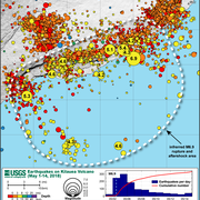
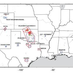
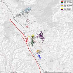
Earthquakes do occur in Antarctica, but not very often. There have been some big earthquakes--including one magnitude 8.1--in the Balleny Islands (between Antarctica and New Zealand). The boundary between the Scotia Plate and the Antarctic Plate just grazes the north tip of the Antarctic Peninsula (look "northwest" from the Pole toward South America). There is also a hint of a line of seismicity off the west coast of the Antarctic Peninsula and some activity in the Kerguelen Plateau (in the Indian Ocean "northeast" from the South Pole). The Kerguelen Plateau is within the Antarctic Plate but it is not part of the Antarctic Continent. As with the interior area of all tectonic plates, earthquakes can and do occur in Antarctica, but they are much less frequent than earthquakes on the plate boundaries.
Relative to other plates (such as Australia or North America), Antarctica has fewer seismic stations to record earthquakes in the interior. Even though there are 76 stations in Antarctica that report data to IRIS (Incorporated Research Institutions for Seismology), all but two of them are along the edge of the continent (as of April 2019). The Global Seismographic Network (GSN) has only 4 stations on Antarctica. In the absence of seismic stations throughout the continent, smaller earthquakes are much more likely to go undetected.
The interior of Antarctica also has icequakes which, although much smaller, are perhaps more frequent than earthquakes. Icequakes are similar to earthquakes but occur within the ice sheet itself instead of the land underneath the ice. Some polar observers have said they can hear the icequakes and see them on the South Pole seismograph station, but they are much too small to be seen on enough stations to obtain a location.
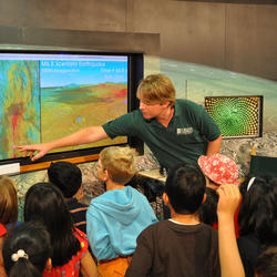
Learn more: Listening to the Earth at the South Pole


Penguins huddle together near Erebus Bay, Antarctica. Images were obtained under NMFS Permit No: 1032-1917.
Penguins huddle together near Erebus Bay, Antarctica. Images were obtained under NMFS Permit No: 1032-1917.

Mount Erebus in background of Inaccessible Island. Images were obtained under NMFS Permit No: 1032-1917.
Mount Erebus in background of Inaccessible Island. Images were obtained under NMFS Permit No: 1032-1917.

Mount Erebus in background. Little Razorback (left) and Big Razorback (right) islands are sites of seal colonies. Images were obtained under NMFS Permit No: 1032-1917.
Mount Erebus in background. Little Razorback (left) and Big Razorback (right) islands are sites of seal colonies. Images were obtained under NMFS Permit No: 1032-1917.

Photo by USGS scientist William A Link at Erebus Bay, Antarctica. Images were obtained under NMFS Permit No: 1032-1917.
Photo by USGS scientist William A Link at Erebus Bay, Antarctica. Images were obtained under NMFS Permit No: 1032-1917.
In our second Earth Science Week installment, we talk with scientist Richie Williams about the USGS's amazing new satellite imagery of Antarctica as well as what's going on with ice on the southernmost continent.
In our second Earth Science Week installment, we talk with scientist Richie Williams about the USGS's amazing new satellite imagery of Antarctica as well as what's going on with ice on the southernmost continent.

In stunning, up-close and personal detail, LIMA brings Antarctica to life, both for the scientific community and the general public at large.
In stunning, up-close and personal detail, LIMA brings Antarctica to life, both for the scientific community and the general public at large.
Penguins huddle together near Erebus Bay, Antarctica. Images were obtained under NMFS Permit No: 1032-1917.
Penguins huddle together near Erebus Bay, Antarctica. Images were obtained under NMFS Permit No: 1032-1917.
Mount Erebus in background of Inaccessible Island. Images were obtained under NMFS Permit No: 1032-1917.
Mount Erebus in background of Inaccessible Island. Images were obtained under NMFS Permit No: 1032-1917.
Mount Erebus in background. Little Razorback (left) and Big Razorback (right) islands are sites of seal colonies. Images were obtained under NMFS Permit No: 1032-1917.
Mount Erebus in background. Little Razorback (left) and Big Razorback (right) islands are sites of seal colonies. Images were obtained under NMFS Permit No: 1032-1917.
Photo by USGS scientist William A Link at Erebus Bay, Antarctica. Images were obtained under NMFS Permit No: 1032-1917.
Photo by USGS scientist William A Link at Erebus Bay, Antarctica. Images were obtained under NMFS Permit No: 1032-1917.
In our second Earth Science Week installment, we talk with scientist Richie Williams about the USGS's amazing new satellite imagery of Antarctica as well as what's going on with ice on the southernmost continent.
In our second Earth Science Week installment, we talk with scientist Richie Williams about the USGS's amazing new satellite imagery of Antarctica as well as what's going on with ice on the southernmost continent.
In stunning, up-close and personal detail, LIMA brings Antarctica to life, both for the scientific community and the general public at large.
In stunning, up-close and personal detail, LIMA brings Antarctica to life, both for the scientific community and the general public at large.
