


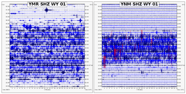
Webicorders of Yellowstone Seismic Network stations YMR (West Entrance road) and YNM (Norris Geyser Basin Museum) showing traffic signals (left) and visitors walking (right) during daytime hours. Both records span the entire 24-hour period of July 23, 2024, MDT.
Does the Latest Earthquakes map show non-earthquake seismic events?
In addition to naturally occurring earthquakes, human activities such as mining and construction blasts can sometimes produce seismic waves large enough to be detected on the USGS national seismic network. These artificially-generated events have a different seismic ‘fingerprint’ from tectonic earthquakes, so they can be discerned by a seismologist when reviewed.
Specifically, small quarry blasts tend to have a shorter surface wave ‘echo’ than natural earthquakes. Seismologists also note if the blast was in an area NOT known for earthquakes and if it was located within 1-2 miles of an active quarrying operation. The USGS no longer does a systematic review of mining seismicity, but these events can sometimes be identified using certain criteria.
If we determine a seismic event to be a mining blast or some other non-earthquake event, we will designate it on our Latest Earthquakes map using a diamond icon. When searching the Earthquake Catalog, users can find non-earthquake events using ‘Advanced Options>Event Type’.
Additionally, IRIS (a USGS research partner) has an Exotic Seismic Events catalog.
Learn more:
- Routine United States Mining Seismicity
- Evidence Used in Identifying Routine Mining Seismicity
- Earthquake Booms, Seneca Guns, and Other Sounds
Related
How can you tell the difference between an explosion and an earthquake on a seismogram?
Explosions and earthquakes both release a large amount of energy very quickly, and both can be recorded by seismic instruments. However, because the forces involved in each are very different, the waveforms that each creates look different. Nuclear tests are very near the surface of the earth; all of the energy is released from a small volume surrounding the device. Earthquakes are typically...
What are those booms I sometimes hear before or during an earthquake?
"Booms" have been reported for a long time, and they tend to occur more in the Northeastern US and along the East Coast. Of course, most "booms" that people hear or experience are actually some type of cultural noise, such as some type of explosion, a large vehicle going by, or sometimes a sonic boom, but there have been many reports of "booms" that cannot be explained by man-made sources. No one...
What does an earthquake feel like?
The way an earthquake feels depends on where you are, where the earthquake is, and how big the earthquake is: A large earthquake nearby will feel like a sudden large jolt followed quickly by more strong shaking that may last a few seconds or up to a couple of minutes if it's a rare great event. The shaking will feel violent and it will be difficult to stand up. The contents of your house will be a...
What are the earthquake hazards/risks where I live?
Determining your risk with regard to earthquakes, or more precisely shaking from earthquakes, isn't as simple as finding the nearest fault. The chances of experiencing shaking from an earthquake and/or having property damage is dependent on many different factors. The National Hazard Maps use all available data to estimate the chances of shaking (of different strengths and frequencies) across the...
Where do earthquakes occur?
Earthquakes can strike any location at any time, but history shows they occur in the same general patterns year after year, principally in three large zones of the earth: The world's greatest earthquake belt, the circum-Pacific seismic belt, is found along the rim of the Pacific Ocean, where about 81 percent of our planet's largest earthquakes occur. It has earned the nickname "Ring of Fire". Why...
Where can I search an earthquake catalog for past events?
You might be able to find what you’re looking for using our collection of Earthquake Lists, so check that first. If that doesn’t work, use one of these Earthquake Catalog Search webpages: World-wide Earthquakes Catalog (M4.5+ worldwide, M2.5+ U.S.) Historic ANSS (Advanced National Seismic System) Composite Catalog (M4.5+ world-wide, all magnitudes U.S.)
Did I feel an earthquake? Can I report feeling an earthquake?
Report an earthquake experience or related observation through the Did You Feel It? citizen science webpage. The best way to do this is to click on the earthquake that you think you felt on one of the lists on the Earthquakes webpage, and then select the "Tell Us!" link. If you don't see the earthquake you think you felt, use the green "Report an Unknown Event" button on our Did You Feel It? page...
Where can I see current or past seismograms?
The USGS Earthquake Hazards Program has helicorders (seismogram displays) available for several areas in the United States and the World. Our research partner IRIS (Incorporated Research Institutions for Seismology) has two applications, the Station Monitor and the Global Seismogram Viewer, for viewing seismograms. IRIS also supplies software that allows users to collect and view seismic data from...
How do seismologists locate an earthquake?
When an earthquake occurs, one of the first questions is "where was it?" The location may tell us what fault it was on and where damage (if any) most likely occurred. Unfortunately, Earth is not transparent and we can't just see or photograph the earthquake disturbance like meteorologists can photograph clouds. When an earthquake occurs, it generates an expanding wavefront from the earthquake...
Examples of seismic noise in Yellowstone caused by people
Webicorders of Yellowstone Seismic Network stations YMR (West Entrance road) and YNM (Norris Geyser Basin Museum) showing traffic signals (left) and visitors walking (right) during daytime hours. Both records span the entire 24-hour period of July 23, 2024, MDT.

Seismic and infrasound data for the April 15, 2024, hydrothermal explosion on Porcelain Terrace at Norris Geyser Basin
linkSeismic and infrasound data for the April 15, 2024, hydrothermal explosion on Porcelain Terrace at Norris Geyser Basin. Top plot is seismic data from the YNM station, located at the Norris Geyser Basin Museum. Middle plot is seismic data from station YNB, in the Ragged Hills of Norris Geyser Basin. Bottom plot is infrasound data from station YNB.&nb

Seismic signal of an icequake on Yellowstone Lake from January 24, 2022.
Signals from a suspected icequake that occurred on Yellowstone Lake recorded at Yellowstone Seismic Network stations YLA on Lake Butte (top) and YTP at The Promontory (bottom 3 plots). Plot shows about 2 minutes of data from January 24, 2022, starting at about 7:43:34 p.m. MST. YLA waveform (YLA EHZ) was recorded on a vertical short-period sensor.
Signals from a suspected icequake that occurred on Yellowstone Lake recorded at Yellowstone Seismic Network stations YLA on Lake Butte (top) and YTP at The Promontory (bottom 3 plots). Plot shows about 2 minutes of data from January 24, 2022, starting at about 7:43:34 p.m. MST. YLA waveform (YLA EHZ) was recorded on a vertical short-period sensor.
Freeport_McMoRan-Safford_Mine_photo.jpg
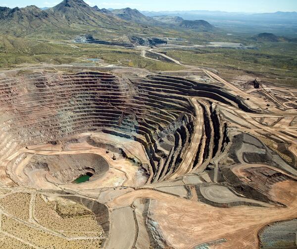
Photograph of Freeport McMoRan-Safford Copper Mine in Arizona. Photograph taken by Thomas J. Porter (USGS) on September 19, 2016, Latitude 32.85992 deg N, Longitude -109.622
Photograph of Freeport McMoRan-Safford Copper Mine in Arizona. Photograph taken by Thomas J. Porter (USGS) on September 19, 2016, Latitude 32.85992 deg N, Longitude -109.622

Mine Blast at Silver Bell Mine, Arizona
Mine Blast at Silver Bell Mine, Arizona.
Mine Blast at Silver Bell Mine, Arizona.

Hydrothermal explosion at Biscuit Basin in YNP. These types of even...
Hydrothermal explosion at Biscuit Basin in Yellowstone National Park. These types of events are the most likely explosive hazard from the Yellowstone Volcano.
Hydrothermal explosion at Biscuit Basin in Yellowstone National Park. These types of events are the most likely explosive hazard from the Yellowstone Volcano.
Related
How can you tell the difference between an explosion and an earthquake on a seismogram?
Explosions and earthquakes both release a large amount of energy very quickly, and both can be recorded by seismic instruments. However, because the forces involved in each are very different, the waveforms that each creates look different. Nuclear tests are very near the surface of the earth; all of the energy is released from a small volume surrounding the device. Earthquakes are typically...
What are those booms I sometimes hear before or during an earthquake?
"Booms" have been reported for a long time, and they tend to occur more in the Northeastern US and along the East Coast. Of course, most "booms" that people hear or experience are actually some type of cultural noise, such as some type of explosion, a large vehicle going by, or sometimes a sonic boom, but there have been many reports of "booms" that cannot be explained by man-made sources. No one...
What does an earthquake feel like?
The way an earthquake feels depends on where you are, where the earthquake is, and how big the earthquake is: A large earthquake nearby will feel like a sudden large jolt followed quickly by more strong shaking that may last a few seconds or up to a couple of minutes if it's a rare great event. The shaking will feel violent and it will be difficult to stand up. The contents of your house will be a...
What are the earthquake hazards/risks where I live?
Determining your risk with regard to earthquakes, or more precisely shaking from earthquakes, isn't as simple as finding the nearest fault. The chances of experiencing shaking from an earthquake and/or having property damage is dependent on many different factors. The National Hazard Maps use all available data to estimate the chances of shaking (of different strengths and frequencies) across the...
Where do earthquakes occur?
Earthquakes can strike any location at any time, but history shows they occur in the same general patterns year after year, principally in three large zones of the earth: The world's greatest earthquake belt, the circum-Pacific seismic belt, is found along the rim of the Pacific Ocean, where about 81 percent of our planet's largest earthquakes occur. It has earned the nickname "Ring of Fire". Why...
Where can I search an earthquake catalog for past events?
You might be able to find what you’re looking for using our collection of Earthquake Lists, so check that first. If that doesn’t work, use one of these Earthquake Catalog Search webpages: World-wide Earthquakes Catalog (M4.5+ worldwide, M2.5+ U.S.) Historic ANSS (Advanced National Seismic System) Composite Catalog (M4.5+ world-wide, all magnitudes U.S.)
Did I feel an earthquake? Can I report feeling an earthquake?
Report an earthquake experience or related observation through the Did You Feel It? citizen science webpage. The best way to do this is to click on the earthquake that you think you felt on one of the lists on the Earthquakes webpage, and then select the "Tell Us!" link. If you don't see the earthquake you think you felt, use the green "Report an Unknown Event" button on our Did You Feel It? page...
Where can I see current or past seismograms?
The USGS Earthquake Hazards Program has helicorders (seismogram displays) available for several areas in the United States and the World. Our research partner IRIS (Incorporated Research Institutions for Seismology) has two applications, the Station Monitor and the Global Seismogram Viewer, for viewing seismograms. IRIS also supplies software that allows users to collect and view seismic data from...
How do seismologists locate an earthquake?
When an earthquake occurs, one of the first questions is "where was it?" The location may tell us what fault it was on and where damage (if any) most likely occurred. Unfortunately, Earth is not transparent and we can't just see or photograph the earthquake disturbance like meteorologists can photograph clouds. When an earthquake occurs, it generates an expanding wavefront from the earthquake...
Examples of seismic noise in Yellowstone caused by people
Webicorders of Yellowstone Seismic Network stations YMR (West Entrance road) and YNM (Norris Geyser Basin Museum) showing traffic signals (left) and visitors walking (right) during daytime hours. Both records span the entire 24-hour period of July 23, 2024, MDT.
Webicorders of Yellowstone Seismic Network stations YMR (West Entrance road) and YNM (Norris Geyser Basin Museum) showing traffic signals (left) and visitors walking (right) during daytime hours. Both records span the entire 24-hour period of July 23, 2024, MDT.
Seismic and infrasound data for the April 15, 2024, hydrothermal explosion on Porcelain Terrace at Norris Geyser Basin
linkSeismic and infrasound data for the April 15, 2024, hydrothermal explosion on Porcelain Terrace at Norris Geyser Basin. Top plot is seismic data from the YNM station, located at the Norris Geyser Basin Museum. Middle plot is seismic data from station YNB, in the Ragged Hills of Norris Geyser Basin. Bottom plot is infrasound data from station YNB.&nb
Seismic signal of an icequake on Yellowstone Lake from January 24, 2022.
Signals from a suspected icequake that occurred on Yellowstone Lake recorded at Yellowstone Seismic Network stations YLA on Lake Butte (top) and YTP at The Promontory (bottom 3 plots). Plot shows about 2 minutes of data from January 24, 2022, starting at about 7:43:34 p.m. MST. YLA waveform (YLA EHZ) was recorded on a vertical short-period sensor.
Signals from a suspected icequake that occurred on Yellowstone Lake recorded at Yellowstone Seismic Network stations YLA on Lake Butte (top) and YTP at The Promontory (bottom 3 plots). Plot shows about 2 minutes of data from January 24, 2022, starting at about 7:43:34 p.m. MST. YLA waveform (YLA EHZ) was recorded on a vertical short-period sensor.
Freeport_McMoRan-Safford_Mine_photo.jpg
Photograph of Freeport McMoRan-Safford Copper Mine in Arizona. Photograph taken by Thomas J. Porter (USGS) on September 19, 2016, Latitude 32.85992 deg N, Longitude -109.622
Photograph of Freeport McMoRan-Safford Copper Mine in Arizona. Photograph taken by Thomas J. Porter (USGS) on September 19, 2016, Latitude 32.85992 deg N, Longitude -109.622
Mine Blast at Silver Bell Mine, Arizona
Mine Blast at Silver Bell Mine, Arizona.
Mine Blast at Silver Bell Mine, Arizona.
Hydrothermal explosion at Biscuit Basin in YNP. These types of even...
Hydrothermal explosion at Biscuit Basin in Yellowstone National Park. These types of events are the most likely explosive hazard from the Yellowstone Volcano.
Hydrothermal explosion at Biscuit Basin in Yellowstone National Park. These types of events are the most likely explosive hazard from the Yellowstone Volcano.
Updated Date: February 20, 2025