


Standing masonry buildings in Kathmandu suggest that shaking was not amplified in the valley sediments surrounding Kathmandu
How do I get earthquake hazard maps for locations outside of the U.S.?
The USGS has seismic hazard maps for the US, Alaska, Hawaii, Puerto Rico & U.S. Virgin Islands, Guam & Marianas and Samoa & Pacific Islands. In addition, we have created some other Foreign Hazard Maps for Afghanistan, Haiti, South America, Southeast Asia and the State of Gujarat, India.
For more information about hazard maps for other locations outside of the U.S. visit the GEM (Global Earthquake Model) Foundation website. GEM is a non-profit, public-private partnership that generates seismic hazard maps for the globe by using seismic hazard models from countries that develop their own (including USGS models) and then by filling in the missing areas with their own models. This page lists the countries that have developed their own models that GEM uses. This page shows a map of those model boundaries.
Related
What is a seismic zone, or seismic hazard zone?
Although you may hear the terms “seismic zone” and “seismic hazard zone” used interchangeably, they really describe two slightly different things. A seismic zone is used to describe an area where earthquakes tend to focus; for example, the New Madrid Seismic Zone in the Central United States. A seismic hazard zone describes an area with a particular level of hazard due to earthquakes. Typically, a...
What is seismic hazard? What is a seismic hazard map? How are they made? How are they used? Why are there different maps, and which one should I use?
Seismic hazard is the hazard associated with potential earthquakes in a particular area, and a seismic hazard map shows the relative hazards in different areas. The maps are made by considering what we currently know about: Past faults and earthquakes The behavior of seismic waves as they travel through different parts of the U.S. crust The near-surface site conditions at specific locations of...
What are the earthquake hazards/risks where I live?
Determining your risk with regard to earthquakes, or more precisely shaking from earthquakes, isn't as simple as finding the nearest fault. The chances of experiencing shaking from an earthquake and/or having property damage is dependent on many different factors. The National Hazard Maps use all available data to estimate the chances of shaking (of different strengths and frequencies) across the...
How will my house hold up in an earthquake? Can the USGS send someone out to evaluate my property?
Published maps will only provide generalized, uninterpreted information about specific areas. Every property consists of a unique combination of geologic and structural factors that must be considered to determine what might happen to a house during an earthquake. Therefore, an individual site study is necessary. Geologic factors include: type of underlying material, depth to bedrock, depth of...
How do I decide whether or not to get earthquake insurance?
You should consider the following factors when deciding whether or not to get earthquake insurance: proximity to active earthquake faults seismic history of the region (frequency of earthquakes) time since last earthquake building construction (type of building and foundation) architectural layout materials used quality of workmanship extent to which earthquake resistance was considered by the...
How do earthquakes affect buildings?
Ground shaking is the primary cause of earthquake damage to man-made structures. Many factors influence the strength of earthquake shaking at a site including the earthquake's magnitude, the site's proximity to the fault, the local geology, and the soil type. More than 250 structures throughout the United States have been outfitted with seismic sensors by the USGS National Strong Motion Project...
What is the likelihood of a large earthquake at location X? Is it safe to go to X since they've been having a lot of earthquakes lately?
The National Seismic Hazards Mapping project provides an online Web tool for determining the probability of a large earthquake within 50 kilometers (~31 miles) of a specific location in the United States over a certain time period. The calculation is based on the latest available information from seismic hazard data. However, asking if it's safe to travel somewhere because of recent earthquakes is...
What is the probability that an earthquake is a foreshock to a larger earthquake?
Around the world, the likelihood that an earthquake will be followed by a larger earthquake nearby and within a week is about 5%. When an earthquake occurs, it can trigger other earthquakes nearby in what seismologists call an earthquake sequence. In most sequences, these later earthquakes will be smaller than the first one. The first, largest earthquake is called the mainshock and the later...
What is the probability that an earthquake will occur in the Los Angeles Area? In the San Francisco Bay area?
According to information supplied in the Uniform California Earthquake Rupture Forecast 3: Los Angeles area: Within the next 30 years the probability is: 60% that an earthquake measuring magnitude 6.7 46% that an earthquake measuring magnitude 7 31% that an earthquake measuring magnitude 7.5 will occur in the Los Angeles region. San Francisco Bay area: Within the next 30 years the probability is...
What is the difference between earthquake early warning, earthquake forecasts, earthquake probabilities, and earthquake prediction?
The USGS uses these four terms to refer to four different things. Early warning is a notification that is issued after an earthquake starts. Probabilities and forecasts are comparable to climate probabilities and weather forecasts, while predictions are more like statements of when, where, and how large, which is not yet possible for earthquakes. Here are more detailed descriptions of each...
Can the National Seismic Hazard Maps be used as an earthquake forecast tool for the near future?
Not really. The USGS Seismic Hazard Maps website and the Unified Hazard Tool (for building custom maps) are designed to display the probability of different events that might occur in a several-year to several-decade period. The model bases all probability estimates on the average rate of earthquakes over long periods of time. As you shorten the time window, you should expect greater and greater...
How are engineers working to make roads and buildings safer?
Earthquake engineers are working to make roads and buildings safer in the event of major earthquakes. This includes both improving the design of new buildings and bridges as well as strengthening older units to incorporate the latest advances in seismic and structural engineering. The Federal Emergency Management Agency plays a central role in funding research and development for the purpose of...

Standing Masonry Buildings in Kathmandu, Nepal
Standing masonry buildings in Kathmandu suggest that shaking was not amplified in the valley sediments surrounding Kathmandu
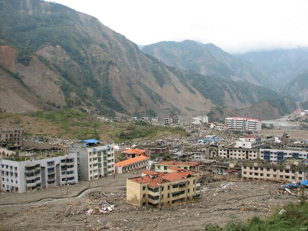
Damage from 2008 Great Sichuan Earthquake in China
The May 12, 2008, Great Sichuan Earthquake, also called the Wenchuan Earthquake, occurred at 14:28 local time, in Sichuan Province, China. The earthquake magnitudes were Mw = 7.9 (USGS), Ms = 8.0 (Chinese Earthquake Administration). The epicenter was 80 km west-northwest of Chengdu, the capital city of Sichuan province.
The May 12, 2008, Great Sichuan Earthquake, also called the Wenchuan Earthquake, occurred at 14:28 local time, in Sichuan Province, China. The earthquake magnitudes were Mw = 7.9 (USGS), Ms = 8.0 (Chinese Earthquake Administration). The epicenter was 80 km west-northwest of Chengdu, the capital city of Sichuan province.

Sichuan Mountains
The 12 May 2008 earthquake was strong enough to pull apart this road in China.
The 12 May 2008 earthquake was strong enough to pull apart this road in China.

Mw6.6 Lushan China Earthquake, April 20 2013
Damage to a village house. Longxingcun.
Damage to a village house. Longxingcun.

Destruction in Downtown Concepcion, Chile
A masonry building in the downtown part of Concepcion, Chile partially collapsed as a result of the M 8.8 earthquake on Feb. 27, 2010. Most modern buildings in Concepcion were undamaged during the earthquake due to the city's adoption of adequate building standards. However, many masonry buildings such as this one were heavily damaged.
A masonry building in the downtown part of Concepcion, Chile partially collapsed as a result of the M 8.8 earthquake on Feb. 27, 2010. Most modern buildings in Concepcion were undamaged during the earthquake due to the city's adoption of adequate building standards. However, many masonry buildings such as this one were heavily damaged.
Related
What is a seismic zone, or seismic hazard zone?
Although you may hear the terms “seismic zone” and “seismic hazard zone” used interchangeably, they really describe two slightly different things. A seismic zone is used to describe an area where earthquakes tend to focus; for example, the New Madrid Seismic Zone in the Central United States. A seismic hazard zone describes an area with a particular level of hazard due to earthquakes. Typically, a...
What is seismic hazard? What is a seismic hazard map? How are they made? How are they used? Why are there different maps, and which one should I use?
Seismic hazard is the hazard associated with potential earthquakes in a particular area, and a seismic hazard map shows the relative hazards in different areas. The maps are made by considering what we currently know about: Past faults and earthquakes The behavior of seismic waves as they travel through different parts of the U.S. crust The near-surface site conditions at specific locations of...
What are the earthquake hazards/risks where I live?
Determining your risk with regard to earthquakes, or more precisely shaking from earthquakes, isn't as simple as finding the nearest fault. The chances of experiencing shaking from an earthquake and/or having property damage is dependent on many different factors. The National Hazard Maps use all available data to estimate the chances of shaking (of different strengths and frequencies) across the...
How will my house hold up in an earthquake? Can the USGS send someone out to evaluate my property?
Published maps will only provide generalized, uninterpreted information about specific areas. Every property consists of a unique combination of geologic and structural factors that must be considered to determine what might happen to a house during an earthquake. Therefore, an individual site study is necessary. Geologic factors include: type of underlying material, depth to bedrock, depth of...
How do I decide whether or not to get earthquake insurance?
You should consider the following factors when deciding whether or not to get earthquake insurance: proximity to active earthquake faults seismic history of the region (frequency of earthquakes) time since last earthquake building construction (type of building and foundation) architectural layout materials used quality of workmanship extent to which earthquake resistance was considered by the...
How do earthquakes affect buildings?
Ground shaking is the primary cause of earthquake damage to man-made structures. Many factors influence the strength of earthquake shaking at a site including the earthquake's magnitude, the site's proximity to the fault, the local geology, and the soil type. More than 250 structures throughout the United States have been outfitted with seismic sensors by the USGS National Strong Motion Project...
What is the likelihood of a large earthquake at location X? Is it safe to go to X since they've been having a lot of earthquakes lately?
The National Seismic Hazards Mapping project provides an online Web tool for determining the probability of a large earthquake within 50 kilometers (~31 miles) of a specific location in the United States over a certain time period. The calculation is based on the latest available information from seismic hazard data. However, asking if it's safe to travel somewhere because of recent earthquakes is...
What is the probability that an earthquake is a foreshock to a larger earthquake?
Around the world, the likelihood that an earthquake will be followed by a larger earthquake nearby and within a week is about 5%. When an earthquake occurs, it can trigger other earthquakes nearby in what seismologists call an earthquake sequence. In most sequences, these later earthquakes will be smaller than the first one. The first, largest earthquake is called the mainshock and the later...
What is the probability that an earthquake will occur in the Los Angeles Area? In the San Francisco Bay area?
According to information supplied in the Uniform California Earthquake Rupture Forecast 3: Los Angeles area: Within the next 30 years the probability is: 60% that an earthquake measuring magnitude 6.7 46% that an earthquake measuring magnitude 7 31% that an earthquake measuring magnitude 7.5 will occur in the Los Angeles region. San Francisco Bay area: Within the next 30 years the probability is...
What is the difference between earthquake early warning, earthquake forecasts, earthquake probabilities, and earthquake prediction?
The USGS uses these four terms to refer to four different things. Early warning is a notification that is issued after an earthquake starts. Probabilities and forecasts are comparable to climate probabilities and weather forecasts, while predictions are more like statements of when, where, and how large, which is not yet possible for earthquakes. Here are more detailed descriptions of each...
Can the National Seismic Hazard Maps be used as an earthquake forecast tool for the near future?
Not really. The USGS Seismic Hazard Maps website and the Unified Hazard Tool (for building custom maps) are designed to display the probability of different events that might occur in a several-year to several-decade period. The model bases all probability estimates on the average rate of earthquakes over long periods of time. As you shorten the time window, you should expect greater and greater...
How are engineers working to make roads and buildings safer?
Earthquake engineers are working to make roads and buildings safer in the event of major earthquakes. This includes both improving the design of new buildings and bridges as well as strengthening older units to incorporate the latest advances in seismic and structural engineering. The Federal Emergency Management Agency plays a central role in funding research and development for the purpose of...
Standing Masonry Buildings in Kathmandu, Nepal
Standing masonry buildings in Kathmandu suggest that shaking was not amplified in the valley sediments surrounding Kathmandu
Standing masonry buildings in Kathmandu suggest that shaking was not amplified in the valley sediments surrounding Kathmandu
Damage from 2008 Great Sichuan Earthquake in China
The May 12, 2008, Great Sichuan Earthquake, also called the Wenchuan Earthquake, occurred at 14:28 local time, in Sichuan Province, China. The earthquake magnitudes were Mw = 7.9 (USGS), Ms = 8.0 (Chinese Earthquake Administration). The epicenter was 80 km west-northwest of Chengdu, the capital city of Sichuan province.
The May 12, 2008, Great Sichuan Earthquake, also called the Wenchuan Earthquake, occurred at 14:28 local time, in Sichuan Province, China. The earthquake magnitudes were Mw = 7.9 (USGS), Ms = 8.0 (Chinese Earthquake Administration). The epicenter was 80 km west-northwest of Chengdu, the capital city of Sichuan province.
Sichuan Mountains
The 12 May 2008 earthquake was strong enough to pull apart this road in China.
The 12 May 2008 earthquake was strong enough to pull apart this road in China.
Mw6.6 Lushan China Earthquake, April 20 2013
Damage to a village house. Longxingcun.
Damage to a village house. Longxingcun.
Destruction in Downtown Concepcion, Chile
A masonry building in the downtown part of Concepcion, Chile partially collapsed as a result of the M 8.8 earthquake on Feb. 27, 2010. Most modern buildings in Concepcion were undamaged during the earthquake due to the city's adoption of adequate building standards. However, many masonry buildings such as this one were heavily damaged.
A masonry building in the downtown part of Concepcion, Chile partially collapsed as a result of the M 8.8 earthquake on Feb. 27, 2010. Most modern buildings in Concepcion were undamaged during the earthquake due to the city's adoption of adequate building standards. However, many masonry buildings such as this one were heavily damaged.
Updated Date: March 3, 2022