
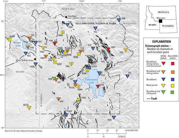
Map of seismic stations in the Yellowstone region, with numbers of channels indicated by number and sensor type by color. Inverted triangles indicate stations operated by University of Utah Seismograph Stations (UUSS), and squares indicate stations operated by other agencies.
How do scientists know what’s going on beneath the ground at Yellowstone? Is Yellowstone monitored for volcanic activity?
Yellowstone Volcano is monitored for signs of volcanic activity. The Yellowstone Volcano Observatory (YVO) is a partnership between the U.S. Geological Survey (USGS), Yellowstone National Park, the University of Utah, the University of Wyoming, UNAVCO, the Montana Bureau of Mines and Geology, the Idaho Geological Survey, and the Wyoming State Geological Survey. YVO closely monitors volcanic activity at Yellowstone and provides real-time data for earthquakes, ground deformation, streamflow, and selected stream temperatures. In addition, YVO scientists collaborate with scientists from around the world to study the Yellowstone volcano.
Learn more:
Related

What type of eruption will Yellowstone have if it erupts again? What type of eruption will Yellowstone have if it erupts again?
The most likely explosive event to occur at Yellowstone is actually a hydrothermal explosion (a rock hurling geyser eruption) or a lava flow. Hydrothermal explosions are very small; they occur in Yellowstone National Park every few years and form a crater a few meters across. Every few thousand years, a hydrothermal explosion will form a crater as much as a few hundred meters across. Though the...

How are volcanic gases measured? How are volcanic gases measured?
Instruments to measure sulfur dioxide and carbon dioxide can be mounted in aircraft to determine the quantity of gas being emitted on a daily basis. Such instruments can also be used in a ground-based mode. An instrument that detects carbon dioxide can be installed on a volcano and configured to send data continuously via radio to an observatory. Sulfur dioxide in volcanic clouds can also be...

How can we tell when a volcano will erupt? How can we tell when a volcano will erupt?
Most volcanoes provide warnings before an eruption. Magmatic eruptions involve the rise of magma toward the surface, which normally generates detectable earthquakes. It can also deform the ground surface and cause anomalous heat flow or changes in the temperature and chemistry of the groundwater and spring waters. Steam-blast eruptions, however, can occur with little or no warning as superheated...

Why is it important to monitor volcanoes? Why is it important to monitor volcanoes?
There are 161 potentially active volcanoes in the United States. According to a 2018 USGS assessment, 57 volcanoes are a high threat or very high threat to public safety. Many of these volcanoes have erupted in the recent past and will erupt again in the foreseeable future. As populations increase, areas near volcanoes are being developed and aviation routes are increasing. As a result, more...

Is Yellowstone overdue for an eruption? When will Yellowstone erupt? Is Yellowstone overdue for an eruption? When will Yellowstone erupt?
Yellowstone is not overdue for an eruption. Volcanoes do not work in predictable ways and their eruptions do not follow predictable schedules. Even so, the math doesn’t work out for the volcano to be “overdue” for an eruption. In terms of large explosions, Yellowstone has experienced three at 2.08, 1.3, and 0.631 million years ago. This comes out to an average of about 725,000 years between...

Why are there so many earthquakes at Yellowstone? Why are there so many earthquakes at Yellowstone?
Almost all earthquakes at Yellowstone are brittle-failure events caused when rocks break due to crustal stresses. Though we've been looking at Yellowstone for years, no one has yet identified "long-period (LP) events" commonly attributed to magma movement. If LP events are observed, that will NOT mean Yellowstone is getting ready to erupt. LP earthquakes commonly occur at other volcanoes in the...

How hot is Yellowstone? How hot is Yellowstone?
Yellowstone is a plateau high in the Rocky Mountains, and is snowbound for over six months per year. The mean annual temperature is 2.2°C (36°F), barely above the freezing point of water. However, Yellowstone is also an active geothermal area with hot springs emerging at ~92°C (~198°F) (the boiling point of water at Yellowstone's mean altitude) and steam vents reported as high as 135°C (275°F)...
Yellowstone seismic network
Map of seismic stations in the Yellowstone region, with numbers of channels indicated by number and sensor type by color. Inverted triangles indicate stations operated by University of Utah Seismograph Stations (UUSS), and squares indicate stations operated by other agencies.

Seismic reflections from the top of the magma reservoir beneath Yellowstone Caldera
Seismic reflections from the top of the magma reservoir beneath Yellowstone CalderaSeismic reflection data showing the top of the magma reservoir beneath Yellowstone Caldera along a cross section that runs from Canyon Village in the northwest (X) to near Lake Butte in the southeast (X`). The top panel shows seismic P-wave (compressional wave) reflectivity, with evidence for the sharp reservoir top labeled.

Aerial view of Biscuit Basin, Yellowstone National Park, showing debris deposited by the July 23, 2024, hydrothermal explosion from Black Diamond Pool
Aerial view of Biscuit Basin, Yellowstone National Park, showing debris deposited by the July 23, 2024, hydrothermal explosion from Black Diamond PoolAerial view of Biscuit Basin, Yellowstone National Park, showing debris deposited by the July 23, 2024, hydrothermal explosion from Black Diamond Pool. Major features are labeled. The main debris field (within dashed yellow line) has a gray appearance. Photo taken by Joe Bueter, Yellowstone National Park, on July 23, 2024.
Aerial view of Biscuit Basin, Yellowstone National Park, showing debris deposited by the July 23, 2024, hydrothermal explosion from Black Diamond Pool
Aerial view of Biscuit Basin, Yellowstone National Park, showing debris deposited by the July 23, 2024, hydrothermal explosion from Black Diamond PoolAerial view of Biscuit Basin, Yellowstone National Park, showing debris deposited by the July 23, 2024, hydrothermal explosion from Black Diamond Pool
Aerial view of Biscuit Basin, Yellowstone National Park, showing debris deposited by the July 23, 2024, hydrothermal explosion from Black Diamond PoolAerial view of Biscuit Basin, Yellowstone National Park, showing debris deposited by the July 23, 2024, hydrothermal explosion from Black Diamond Pool. Major features are labeled. The main debris field (within dashed yellow line) has a gray appearance. Photo taken by Joe Bueter, Yellowstone National Park, on July 23, 2024.

Sapphire Pool, Yellowstone National Park
Sapphire Pool, in Biscuit Basin, steams on a stormy morning. A few “biscuits” remain along the pool’s southern edge (center right of photo) – violent geyser eruptions destroyed hundreds of the features when the pool’s plumbing system changed after being jarred by the 1959 Hebgen Lake earthquake. National Park Service photo by Jacob W. Frank, July 20, 2020.
Sapphire Pool, in Biscuit Basin, steams on a stormy morning. A few “biscuits” remain along the pool’s southern edge (center right of photo) – violent geyser eruptions destroyed hundreds of the features when the pool’s plumbing system changed after being jarred by the 1959 Hebgen Lake earthquake. National Park Service photo by Jacob W. Frank, July 20, 2020.

Chemical/temperature sensor on the floor of Yellowstone Lake
Chemical/temperature sensor on the floor of Yellowstone LakeSensor (left) and battery/electronics package (right) at vent location A in the Deep Hole area of Yellowstone Lake. Photo was taken immediately before recovery from the lake floor. Notice the battery/electronics package slightly submerged in sediment.

Helicopter carrying geophysical sensors above Yellowstone National Park
Helicopter carrying geophysical sensors above Yellowstone National ParkHelicopter with airborne electromagnetics sensors dangling beneath as it flies over a portion of Yellowstone National Park. Photo by Jeff Hungerford, November 2016.

Inside USGS, No. 6, Ken Pierce, Heavy Breathing of Yellowstone Caldera
Inside USGS, No. 6, Ken Pierce, Heavy Breathing of Yellowstone CalderaDr. Kenneth Pierce studied the geology and geomorphology of the greater Yellowstone area for nearly his entire career with the U.S. Geological Survey. From 1965 to present, Dr.

Inside USGS, No. 4, Robert B. Smith
Robert B. Smith of the University of Utah has been collaborating with USGS scientists on Yellowstone geologic topics since the 1960’s. In this interview Bob describes nuances of the Yellowstone volcano story.
Robert B. Smith of the University of Utah has been collaborating with USGS scientists on Yellowstone geologic topics since the 1960’s. In this interview Bob describes nuances of the Yellowstone volcano story.

The Yellowstone Volcano: Past, Present and Future
Public Lecture on Yellowstone Volcano by Jake Lowenstern at Menlo Park, CA on January 23, 2014. The Q&A at the end of the talk can be found on the original source video (Source URL).
Public Lecture on Yellowstone Volcano by Jake Lowenstern at Menlo Park, CA on January 23, 2014. The Q&A at the end of the talk can be found on the original source video (Source URL).

Yellowstone Temperature Logger
Yellowstone Volcano Observatory temperature logger and radio transmitter installed in a weatherproof case under a public boardwalk in Yellowstone National Park. The white cable leads to a temperature sensor in the water under the rocks.
Yellowstone Volcano Observatory temperature logger and radio transmitter installed in a weatherproof case under a public boardwalk in Yellowstone National Park. The white cable leads to a temperature sensor in the water under the rocks.

USGS Scientists Installing Temperature Sensor
USGS scientists Laura Clor and Tim Moloney installing a temperature sensor under a public boardwalk in Norris Geyser Basin, Yellowstone National Park.
USGS scientists Laura Clor and Tim Moloney installing a temperature sensor under a public boardwalk in Norris Geyser Basin, Yellowstone National Park.
")
Yes! Yellowstone is a Volcano (Part 1 of 3)
USGS Scientist-in-Charge of Yellowstone Volcano Observatory, Jake Lowenstern, answers the following questions to explain volcanic features at Yellowstone: "How do we know Yellowstone is a volcano?", "What is a Supervolcano?", "What is a Caldera?","Why are there geysers at Yellowstone?", and "What are the other geologic hazards in Yellowstone?"
USGS Scientist-in-Charge of Yellowstone Volcano Observatory, Jake Lowenstern, answers the following questions to explain volcanic features at Yellowstone: "How do we know Yellowstone is a volcano?", "What is a Supervolcano?", "What is a Caldera?","Why are there geysers at Yellowstone?", and "What are the other geologic hazards in Yellowstone?"
")
Yellowstone Eruptions (Part 3 of 3)
USGS Scientist-in-Charge of Yellowstone Volcano Observatory, Jake Lowenstern, answers the following questions to explain volcanic eruptions at Yellowstone: When was the last supereruption at Yellowstone?", "Have any eruptions occurred since the last supereruption?", "Is Yellowstone overdue for an eruption?", "What does the magma below indicate about a possible erupt
USGS Scientist-in-Charge of Yellowstone Volcano Observatory, Jake Lowenstern, answers the following questions to explain volcanic eruptions at Yellowstone: When was the last supereruption at Yellowstone?", "Have any eruptions occurred since the last supereruption?", "Is Yellowstone overdue for an eruption?", "What does the magma below indicate about a possible erupt
")
Yellowstone Volcano Observatory (Part 2 of 3)
USGS Scientist-in-Charge of Yellowstone Volcano Observatory, Jake Lowenstern, answers the following questions to provide a tour of the Yellowstone Volcano Observatory: "What is YVO?", "How do you monitor volcanic activity at Yellowstone?", "How are satellites used to study deformation?", "Do you monitor geysers or any other aspect of the Park?", "Are earthquakes and
USGS Scientist-in-Charge of Yellowstone Volcano Observatory, Jake Lowenstern, answers the following questions to provide a tour of the Yellowstone Volcano Observatory: "What is YVO?", "How do you monitor volcanic activity at Yellowstone?", "How are satellites used to study deformation?", "Do you monitor geysers or any other aspect of the Park?", "Are earthquakes and
Related
What type of eruption will Yellowstone have if it erupts again? What type of eruption will Yellowstone have if it erupts again?
The most likely explosive event to occur at Yellowstone is actually a hydrothermal explosion (a rock hurling geyser eruption) or a lava flow. Hydrothermal explosions are very small; they occur in Yellowstone National Park every few years and form a crater a few meters across. Every few thousand years, a hydrothermal explosion will form a crater as much as a few hundred meters across. Though the...
How are volcanic gases measured? How are volcanic gases measured?
Instruments to measure sulfur dioxide and carbon dioxide can be mounted in aircraft to determine the quantity of gas being emitted on a daily basis. Such instruments can also be used in a ground-based mode. An instrument that detects carbon dioxide can be installed on a volcano and configured to send data continuously via radio to an observatory. Sulfur dioxide in volcanic clouds can also be...
How can we tell when a volcano will erupt? How can we tell when a volcano will erupt?
Most volcanoes provide warnings before an eruption. Magmatic eruptions involve the rise of magma toward the surface, which normally generates detectable earthquakes. It can also deform the ground surface and cause anomalous heat flow or changes in the temperature and chemistry of the groundwater and spring waters. Steam-blast eruptions, however, can occur with little or no warning as superheated...
Why is it important to monitor volcanoes? Why is it important to monitor volcanoes?
There are 161 potentially active volcanoes in the United States. According to a 2018 USGS assessment, 57 volcanoes are a high threat or very high threat to public safety. Many of these volcanoes have erupted in the recent past and will erupt again in the foreseeable future. As populations increase, areas near volcanoes are being developed and aviation routes are increasing. As a result, more...
Is Yellowstone overdue for an eruption? When will Yellowstone erupt? Is Yellowstone overdue for an eruption? When will Yellowstone erupt?
Yellowstone is not overdue for an eruption. Volcanoes do not work in predictable ways and their eruptions do not follow predictable schedules. Even so, the math doesn’t work out for the volcano to be “overdue” for an eruption. In terms of large explosions, Yellowstone has experienced three at 2.08, 1.3, and 0.631 million years ago. This comes out to an average of about 725,000 years between...
Why are there so many earthquakes at Yellowstone? Why are there so many earthquakes at Yellowstone?
Almost all earthquakes at Yellowstone are brittle-failure events caused when rocks break due to crustal stresses. Though we've been looking at Yellowstone for years, no one has yet identified "long-period (LP) events" commonly attributed to magma movement. If LP events are observed, that will NOT mean Yellowstone is getting ready to erupt. LP earthquakes commonly occur at other volcanoes in the...
How hot is Yellowstone? How hot is Yellowstone?
Yellowstone is a plateau high in the Rocky Mountains, and is snowbound for over six months per year. The mean annual temperature is 2.2°C (36°F), barely above the freezing point of water. However, Yellowstone is also an active geothermal area with hot springs emerging at ~92°C (~198°F) (the boiling point of water at Yellowstone's mean altitude) and steam vents reported as high as 135°C (275°F)...
Yellowstone seismic network
Map of seismic stations in the Yellowstone region, with numbers of channels indicated by number and sensor type by color. Inverted triangles indicate stations operated by University of Utah Seismograph Stations (UUSS), and squares indicate stations operated by other agencies.
Map of seismic stations in the Yellowstone region, with numbers of channels indicated by number and sensor type by color. Inverted triangles indicate stations operated by University of Utah Seismograph Stations (UUSS), and squares indicate stations operated by other agencies.
Seismic reflections from the top of the magma reservoir beneath Yellowstone Caldera
Seismic reflections from the top of the magma reservoir beneath Yellowstone CalderaSeismic reflection data showing the top of the magma reservoir beneath Yellowstone Caldera along a cross section that runs from Canyon Village in the northwest (X) to near Lake Butte in the southeast (X`). The top panel shows seismic P-wave (compressional wave) reflectivity, with evidence for the sharp reservoir top labeled.
Aerial view of Biscuit Basin, Yellowstone National Park, showing debris deposited by the July 23, 2024, hydrothermal explosion from Black Diamond Pool
Aerial view of Biscuit Basin, Yellowstone National Park, showing debris deposited by the July 23, 2024, hydrothermal explosion from Black Diamond PoolAerial view of Biscuit Basin, Yellowstone National Park, showing debris deposited by the July 23, 2024, hydrothermal explosion from Black Diamond Pool. Major features are labeled. The main debris field (within dashed yellow line) has a gray appearance. Photo taken by Joe Bueter, Yellowstone National Park, on July 23, 2024.
Aerial view of Biscuit Basin, Yellowstone National Park, showing debris deposited by the July 23, 2024, hydrothermal explosion from Black Diamond Pool
Aerial view of Biscuit Basin, Yellowstone National Park, showing debris deposited by the July 23, 2024, hydrothermal explosion from Black Diamond PoolAerial view of Biscuit Basin, Yellowstone National Park, showing debris deposited by the July 23, 2024, hydrothermal explosion from Black Diamond Pool
Aerial view of Biscuit Basin, Yellowstone National Park, showing debris deposited by the July 23, 2024, hydrothermal explosion from Black Diamond PoolAerial view of Biscuit Basin, Yellowstone National Park, showing debris deposited by the July 23, 2024, hydrothermal explosion from Black Diamond Pool. Major features are labeled. The main debris field (within dashed yellow line) has a gray appearance. Photo taken by Joe Bueter, Yellowstone National Park, on July 23, 2024.
Sapphire Pool, Yellowstone National Park
Sapphire Pool, in Biscuit Basin, steams on a stormy morning. A few “biscuits” remain along the pool’s southern edge (center right of photo) – violent geyser eruptions destroyed hundreds of the features when the pool’s plumbing system changed after being jarred by the 1959 Hebgen Lake earthquake. National Park Service photo by Jacob W. Frank, July 20, 2020.
Sapphire Pool, in Biscuit Basin, steams on a stormy morning. A few “biscuits” remain along the pool’s southern edge (center right of photo) – violent geyser eruptions destroyed hundreds of the features when the pool’s plumbing system changed after being jarred by the 1959 Hebgen Lake earthquake. National Park Service photo by Jacob W. Frank, July 20, 2020.
Chemical/temperature sensor on the floor of Yellowstone Lake
Chemical/temperature sensor on the floor of Yellowstone LakeSensor (left) and battery/electronics package (right) at vent location A in the Deep Hole area of Yellowstone Lake. Photo was taken immediately before recovery from the lake floor. Notice the battery/electronics package slightly submerged in sediment.
Helicopter carrying geophysical sensors above Yellowstone National Park
Helicopter carrying geophysical sensors above Yellowstone National ParkHelicopter with airborne electromagnetics sensors dangling beneath as it flies over a portion of Yellowstone National Park. Photo by Jeff Hungerford, November 2016.
Inside USGS, No. 6, Ken Pierce, Heavy Breathing of Yellowstone Caldera
Inside USGS, No. 6, Ken Pierce, Heavy Breathing of Yellowstone CalderaDr. Kenneth Pierce studied the geology and geomorphology of the greater Yellowstone area for nearly his entire career with the U.S. Geological Survey. From 1965 to present, Dr.
Inside USGS, No. 4, Robert B. Smith
Robert B. Smith of the University of Utah has been collaborating with USGS scientists on Yellowstone geologic topics since the 1960’s. In this interview Bob describes nuances of the Yellowstone volcano story.
Robert B. Smith of the University of Utah has been collaborating with USGS scientists on Yellowstone geologic topics since the 1960’s. In this interview Bob describes nuances of the Yellowstone volcano story.
The Yellowstone Volcano: Past, Present and Future
Public Lecture on Yellowstone Volcano by Jake Lowenstern at Menlo Park, CA on January 23, 2014. The Q&A at the end of the talk can be found on the original source video (Source URL).
Public Lecture on Yellowstone Volcano by Jake Lowenstern at Menlo Park, CA on January 23, 2014. The Q&A at the end of the talk can be found on the original source video (Source URL).
Yellowstone Temperature Logger
Yellowstone Volcano Observatory temperature logger and radio transmitter installed in a weatherproof case under a public boardwalk in Yellowstone National Park. The white cable leads to a temperature sensor in the water under the rocks.
Yellowstone Volcano Observatory temperature logger and radio transmitter installed in a weatherproof case under a public boardwalk in Yellowstone National Park. The white cable leads to a temperature sensor in the water under the rocks.
USGS Scientists Installing Temperature Sensor
USGS scientists Laura Clor and Tim Moloney installing a temperature sensor under a public boardwalk in Norris Geyser Basin, Yellowstone National Park.
USGS scientists Laura Clor and Tim Moloney installing a temperature sensor under a public boardwalk in Norris Geyser Basin, Yellowstone National Park.
Yes! Yellowstone is a Volcano (Part 1 of 3)
USGS Scientist-in-Charge of Yellowstone Volcano Observatory, Jake Lowenstern, answers the following questions to explain volcanic features at Yellowstone: "How do we know Yellowstone is a volcano?", "What is a Supervolcano?", "What is a Caldera?","Why are there geysers at Yellowstone?", and "What are the other geologic hazards in Yellowstone?"
USGS Scientist-in-Charge of Yellowstone Volcano Observatory, Jake Lowenstern, answers the following questions to explain volcanic features at Yellowstone: "How do we know Yellowstone is a volcano?", "What is a Supervolcano?", "What is a Caldera?","Why are there geysers at Yellowstone?", and "What are the other geologic hazards in Yellowstone?"
Yellowstone Eruptions (Part 3 of 3)
USGS Scientist-in-Charge of Yellowstone Volcano Observatory, Jake Lowenstern, answers the following questions to explain volcanic eruptions at Yellowstone: When was the last supereruption at Yellowstone?", "Have any eruptions occurred since the last supereruption?", "Is Yellowstone overdue for an eruption?", "What does the magma below indicate about a possible erupt
USGS Scientist-in-Charge of Yellowstone Volcano Observatory, Jake Lowenstern, answers the following questions to explain volcanic eruptions at Yellowstone: When was the last supereruption at Yellowstone?", "Have any eruptions occurred since the last supereruption?", "Is Yellowstone overdue for an eruption?", "What does the magma below indicate about a possible erupt
Yellowstone Volcano Observatory (Part 2 of 3)
USGS Scientist-in-Charge of Yellowstone Volcano Observatory, Jake Lowenstern, answers the following questions to provide a tour of the Yellowstone Volcano Observatory: "What is YVO?", "How do you monitor volcanic activity at Yellowstone?", "How are satellites used to study deformation?", "Do you monitor geysers or any other aspect of the Park?", "Are earthquakes and
USGS Scientist-in-Charge of Yellowstone Volcano Observatory, Jake Lowenstern, answers the following questions to provide a tour of the Yellowstone Volcano Observatory: "What is YVO?", "How do you monitor volcanic activity at Yellowstone?", "How are satellites used to study deformation?", "Do you monitor geysers or any other aspect of the Park?", "Are earthquakes and
Updated Date: April 6, 2026