


Annual NLCD is a new generation of land cover mapping that offers annual land cover and land change science products nationwide with nearly four decades of data. Learn more here: https://usgs.gov/annualnlcd
How is the salinity of Great Salt Lake measured?
The salinity of Great Salt Lake is measured by taking specific gravity and temperature measurements and comparing them to standardized values reported in a table. Specific gravity is measured in the field by testing a water sample with a device very similar to a battery or antifreeze tester.
Learn more: Great Salt Lake, Utah
Related
Is saline water used for anything?
In the U.S., about 13 percent of all water used is saline water. But saline water can only be used for certain purposes. The main use is for thermoelectric power-plant cooling. About 5 percent of water used for industrial purposes is saline, and about 53 percent of all water used for mining purposes is saline. Saline water can be desalinated for use as drinking water by putting it through a...
Does the use of pesticides affect our Nation's water quality?
Pesticide use in the United States has increased because not only must we supply our exploding population with food, but crops and food are also grown for export to other countries. The United States has become the largest producer of food products in the world, partly owing to our use of modern chemicals (pesticides) to control the insects, weeds, and other organisms that attack food crops. But...
What can be causing our drinking water to have a reddish color?
Your water might be affected by iron, which is a commonly-occurring constituent of drinking water. Iron tends to add a rusty, reddish-brown (or sometimes yellow) color to water. If the color is more black than red, your water might contain a combination of iron and manganese. Both of these metals can cause staining of plumbing fixtures or laundry, but they are not known to cause health problems...
Where can I find information about my local drinking water supply?
The best way to learn about your local drinking water quality is to read the annual drinking water quality report/consumer confidence report that water suppliers now send out by July 1 of each year. The reports are often sent out with water bills, but they may be sent separately. The reports tell where drinking water comes from, what contaminants are in it, and at what levels. The U.S...
Why are some lakes full of algae and thick plants?
Plants naturally grow in and around lakes, but sometimes lakes and ponds can get an overgrowth of plants, algae, or bacteria. In many cases, humans are responsible. Chemicals that are used on lawns and in agriculture (like nitrogen and potassium) wash into our water systems. Once there, plants and algae have a feast on this “food”. Sometimes overgrowths of cyanobacteria (called “blooms”) can make...
What is the difference between "mountain", "hill", and "peak"; "lake" and "pond"; or "river" and "creek?"
There are no official definitions for generic terms as applied to geographic features. The Geographic Names Information System (GNIS) utilizes 43 broad categories of feature classes defined solely to facilitate retrieval of entries with similar characteristics. Go to GNIS Domestic Names Feature Classes to see the full list. These categories generally match dictionary definitions, but not always...
Where can I find detailed sampling methods for surface water and groundwater?
The National Field Manual for the Collection of Water-Quality Data (National Field Manual) provides guidelines and standard procedures for USGS personnel who collect data used to assess the quality of the Nation’s surface water and groundwater resources. The manual is published as separate chapters. Learn more: Techniques of Water-Resources Investigations Reports

Annual NLCD (1985-2023) Animation for the Great Salt Lake and Salt Lake Valley, Utah
Annual NLCD is a new generation of land cover mapping that offers annual land cover and land change science products nationwide with nearly four decades of data. Learn more here: https://usgs.gov/annualnlcd
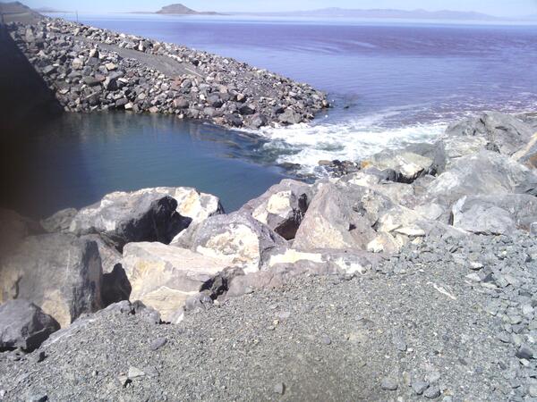
A rocky causeway divides the waters of the Great Salt Lake
A rocky causeway divides the waters of the Great Salt Lake, with distinct color variations visible between the north and south arms.
A rocky causeway divides the waters of the Great Salt Lake, with distinct color variations visible between the north and south arms.

Relationships: new tool - Split-panel map for inspecting timeseries images of Landsat and NLCD from 2001-2016 for Great Salt Lake
linkA split-panel map of Salt Lake City, Utah, highlighting the Great Salt Lake, shows 2006 Landsat imagery on the left side panel and 2006 NLCD, with colorized legend of land use classes, on the right. The animation displays a slider being used to switch between the two different datasets, revealing the land cover classes shown in Landsat imagery.

Great Salt Lake, USGS boat at work
USGS scientists check breach on glass-calm Great Salt Lake in surreal light.
USGS scientists check breach on glass-calm Great Salt Lake in surreal light.

USGS research boat conducting science on the Great Salt Lake.
USGS scientist Robert Baskin takes a boat out on the Great Salt Lake to conduct research.
USGS scientist Robert Baskin takes a boat out on the Great Salt Lake to conduct research.

New Breach Allows Flow on the Great Salt Lake
The new Great Salt Lake breach was opened on Dec. 1 by the Union Pacific Railroad Company. This created a new opening between the north and the south arm of the lake, allowing water to flow between the two sides. This time-lapse video shows the breach opening, which took about two hours.
The new Great Salt Lake breach was opened on Dec. 1 by the Union Pacific Railroad Company. This created a new opening between the north and the south arm of the lake, allowing water to flow between the two sides. This time-lapse video shows the breach opening, which took about two hours.

False-color-composite satellite image of Great Salt Lake, Sept 2016
This is a false-color-composite satellite image of Great Salt Lake, Utah, Sept 2016. Vegetation appears red in image.
This is a false-color-composite satellite image of Great Salt Lake, Utah, Sept 2016. Vegetation appears red in image.

Great Salt Lake Breach at Lakeside, Utah
A gage to measure lake water levels stands dry in the lake bed of the Great Salt Lake. For the first time since it was opened in 1984, water has stopped flowing through the Great Salt Lake causeway breach, an area that allows water to travel between the southern and northern parts of the lake.
A gage to measure lake water levels stands dry in the lake bed of the Great Salt Lake. For the first time since it was opened in 1984, water has stopped flowing through the Great Salt Lake causeway breach, an area that allows water to travel between the southern and northern parts of the lake.

Great Salt Lake, declining water level
Great Salt Lake, declining water level
Great Salt Lake, declining water level

Great Salt Lake beach
USGS hydrologist walks across Great Salt Lake beach to reach receding shoreline.
USGS hydrologist walks across Great Salt Lake beach to reach receding shoreline.
Related
Is saline water used for anything?
In the U.S., about 13 percent of all water used is saline water. But saline water can only be used for certain purposes. The main use is for thermoelectric power-plant cooling. About 5 percent of water used for industrial purposes is saline, and about 53 percent of all water used for mining purposes is saline. Saline water can be desalinated for use as drinking water by putting it through a...
Does the use of pesticides affect our Nation's water quality?
Pesticide use in the United States has increased because not only must we supply our exploding population with food, but crops and food are also grown for export to other countries. The United States has become the largest producer of food products in the world, partly owing to our use of modern chemicals (pesticides) to control the insects, weeds, and other organisms that attack food crops. But...
What can be causing our drinking water to have a reddish color?
Your water might be affected by iron, which is a commonly-occurring constituent of drinking water. Iron tends to add a rusty, reddish-brown (or sometimes yellow) color to water. If the color is more black than red, your water might contain a combination of iron and manganese. Both of these metals can cause staining of plumbing fixtures or laundry, but they are not known to cause health problems...
Where can I find information about my local drinking water supply?
The best way to learn about your local drinking water quality is to read the annual drinking water quality report/consumer confidence report that water suppliers now send out by July 1 of each year. The reports are often sent out with water bills, but they may be sent separately. The reports tell where drinking water comes from, what contaminants are in it, and at what levels. The U.S...
Why are some lakes full of algae and thick plants?
Plants naturally grow in and around lakes, but sometimes lakes and ponds can get an overgrowth of plants, algae, or bacteria. In many cases, humans are responsible. Chemicals that are used on lawns and in agriculture (like nitrogen and potassium) wash into our water systems. Once there, plants and algae have a feast on this “food”. Sometimes overgrowths of cyanobacteria (called “blooms”) can make...
What is the difference between "mountain", "hill", and "peak"; "lake" and "pond"; or "river" and "creek?"
There are no official definitions for generic terms as applied to geographic features. The Geographic Names Information System (GNIS) utilizes 43 broad categories of feature classes defined solely to facilitate retrieval of entries with similar characteristics. Go to GNIS Domestic Names Feature Classes to see the full list. These categories generally match dictionary definitions, but not always...
Where can I find detailed sampling methods for surface water and groundwater?
The National Field Manual for the Collection of Water-Quality Data (National Field Manual) provides guidelines and standard procedures for USGS personnel who collect data used to assess the quality of the Nation’s surface water and groundwater resources. The manual is published as separate chapters. Learn more: Techniques of Water-Resources Investigations Reports
Annual NLCD (1985-2023) Animation for the Great Salt Lake and Salt Lake Valley, Utah
Annual NLCD is a new generation of land cover mapping that offers annual land cover and land change science products nationwide with nearly four decades of data. Learn more here: https://usgs.gov/annualnlcd
Annual NLCD is a new generation of land cover mapping that offers annual land cover and land change science products nationwide with nearly four decades of data. Learn more here: https://usgs.gov/annualnlcd
A rocky causeway divides the waters of the Great Salt Lake
A rocky causeway divides the waters of the Great Salt Lake, with distinct color variations visible between the north and south arms.
A rocky causeway divides the waters of the Great Salt Lake, with distinct color variations visible between the north and south arms.
Relationships: new tool - Split-panel map for inspecting timeseries images of Landsat and NLCD from 2001-2016 for Great Salt Lake
linkA split-panel map of Salt Lake City, Utah, highlighting the Great Salt Lake, shows 2006 Landsat imagery on the left side panel and 2006 NLCD, with colorized legend of land use classes, on the right. The animation displays a slider being used to switch between the two different datasets, revealing the land cover classes shown in Landsat imagery.
Great Salt Lake, USGS boat at work
USGS scientists check breach on glass-calm Great Salt Lake in surreal light.
USGS scientists check breach on glass-calm Great Salt Lake in surreal light.
USGS research boat conducting science on the Great Salt Lake.
USGS scientist Robert Baskin takes a boat out on the Great Salt Lake to conduct research.
USGS scientist Robert Baskin takes a boat out on the Great Salt Lake to conduct research.
New Breach Allows Flow on the Great Salt Lake
The new Great Salt Lake breach was opened on Dec. 1 by the Union Pacific Railroad Company. This created a new opening between the north and the south arm of the lake, allowing water to flow between the two sides. This time-lapse video shows the breach opening, which took about two hours.
The new Great Salt Lake breach was opened on Dec. 1 by the Union Pacific Railroad Company. This created a new opening between the north and the south arm of the lake, allowing water to flow between the two sides. This time-lapse video shows the breach opening, which took about two hours.
False-color-composite satellite image of Great Salt Lake, Sept 2016
This is a false-color-composite satellite image of Great Salt Lake, Utah, Sept 2016. Vegetation appears red in image.
This is a false-color-composite satellite image of Great Salt Lake, Utah, Sept 2016. Vegetation appears red in image.
Great Salt Lake Breach at Lakeside, Utah
A gage to measure lake water levels stands dry in the lake bed of the Great Salt Lake. For the first time since it was opened in 1984, water has stopped flowing through the Great Salt Lake causeway breach, an area that allows water to travel between the southern and northern parts of the lake.
A gage to measure lake water levels stands dry in the lake bed of the Great Salt Lake. For the first time since it was opened in 1984, water has stopped flowing through the Great Salt Lake causeway breach, an area that allows water to travel between the southern and northern parts of the lake.
Great Salt Lake, declining water level
Great Salt Lake, declining water level
Great Salt Lake, declining water level
Great Salt Lake beach
USGS hydrologist walks across Great Salt Lake beach to reach receding shoreline.
USGS hydrologist walks across Great Salt Lake beach to reach receding shoreline.
Updated Date: November 29, 2024