


This video is a recording of a previous webinar entitled: “The New Annual (1985-2023) National Land Cover Database: Improving on a 30-year Legacy.” This webinar was recorded on October 24, 2024 at the USGS EROS.
Where can I get global land cover data?
Access global land cover data using two sources in EarthExplorer:
Global Land Cover Characterization (GLCC):
- In EarthExplorer, select "GLCC" under "Land Cover" in the "Data Sets" tab.
- Derived from 1-km Advanced Very High Resolution Radiometer (AVHRR) data collected April 1992-March 1993.
Moderate Resolution Imaging Spectroradiometer (MODIS) Land Cover:
- In EarthExplorer, select "NASA LPDAAC Collections" under the "Data Sets" tab.
- Then select "MODIS Land Cover-V6".
- MODIS MCD12C1 V6 (Land Cover Climate Modeling Grid) - data at yearly intervals 2001-2018.
- MODIS MCD12Q1 V6 (Land Cover Type) - data at yearly intervals 2001-2018.
- MODIS MCD12Q2 V6 (Land Cover Dynamics) - data at yearly intervals 2001-2017.
Learn more:
- Global Ecosystems
- Global Climate Data (NOAA)
- NOAAView Global Data (NOAA)
- Map of Worldwide Croplands (USGS news release)
- Global Soil Regions map and data (USDA NRCS)
- EARTHDATA (NASA)
- Earthshots
Related
Where can I find land cover data for the U.S.?
Information on land cover data from the National Land Cover Database (NLCD) is on the Multi-Resolution Land Characteristics (MRLC) website. The MRLC website serves several different vintages (dates) of the National Land Cover Database beginning with the 2001 data.
How do changes in climate and land use relate to one another?
The link between land use and the climate is complex. First, land cover--as shaped by land use practices--affects the global concentration of greenhouse gases. Second, while land use change is an important driver of climate change, a changing climate can lead to changes in land use and land cover. For example, farmers might shift from their customary crops to crops that will have higher economic...
Where can I get global elevation data?
Download free global elevation data products using AppEEARS or EarthExplorer. Free registration is required. In AppEEARS: Download Aster Global Digital Elevation Model (GDEM version 3) 1-arc-second (30m) resolution GeoTIFF format Acquired 2000-2013 In EarthExplorer, select “Digital Elevation” under the "Data Sets" tab and choose an option: Shuttle Radar Topography Mission (SRTM) 1-arc-second...
What are the best Landsat spectral bands for use in my research?
The Spectral Characteristics Viewer is an interactive tool that can be used to visualize how the bands, or channels, of different satellite sensors measure the intensity of the many wavelengths (colors) of light. This is also known as the relative spectral response (RSR). By overlaying the spectral curves from different features (spectra), one can determine which bands of the selected sensor will...
 National Land Cover Database: Improving on a 30-Year Legacy")
The New Annual (1985-2023) National Land Cover Database: Improving on a 30-Year Legacy
This video is a recording of a previous webinar entitled: “The New Annual (1985-2023) National Land Cover Database: Improving on a 30-year Legacy.” This webinar was recorded on October 24, 2024 at the USGS EROS.

Annual NLCD Animation for Sioux Falls, South Dakota
Annual NLCD Animation for Sioux Falls, South Dakota. Annual NLCD is a new generation of land cover mapping that offers annual land cover and land change science products nationwide with nearly four decades of data. Learn more here: https://usgs.gov/annualnlcd
Annual NLCD Animation for Sioux Falls, South Dakota. Annual NLCD is a new generation of land cover mapping that offers annual land cover and land change science products nationwide with nearly four decades of data. Learn more here: https://usgs.gov/annualnlcd

Annual NLCD (2023) for the Conterminous United States
Annual NLCD is a new generation of land cover mapping that offers annual land cover and land change science products nationwide with nearly four decades of data. Learn more here: https://usgs.gov/annualnlcd
Annual NLCD is a new generation of land cover mapping that offers annual land cover and land change science products nationwide with nearly four decades of data. Learn more here: https://usgs.gov/annualnlcd

Annual NLCD (1985-2023) Animation for the Great Salt Lake and Salt Lake Valley, Utah
Annual NLCD is a new generation of land cover mapping that offers annual land cover and land change science products nationwide with nearly four decades of data. Learn more here: https://usgs.gov/annualnlcd
Annual NLCD is a new generation of land cover mapping that offers annual land cover and land change science products nationwide with nearly four decades of data. Learn more here: https://usgs.gov/annualnlcd

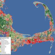
Annual NLCD Land Cover 2023
A zoomed in image of Annual NLCD Land Cover in 2023 for Silverdale, Washington. Annual NLCD Land Cover science product represents the most likely thematic land cover type of the Anderson Level II classes. Learn more about Annual NLCD.
A zoomed in image of Annual NLCD Land Cover in 2023 for Silverdale, Washington. Annual NLCD Land Cover science product represents the most likely thematic land cover type of the Anderson Level II classes. Learn more about Annual NLCD.

Annual NLCD Land Cover 1985
Zoomed in image of Annual NLCD Land Cover in 1985. Annual NLCD Land Cover science product represents the most likely thematic land cover type of the Anderson Level II classes.
Zoomed in image of Annual NLCD Land Cover in 1985. Annual NLCD Land Cover science product represents the most likely thematic land cover type of the Anderson Level II classes.

Land Cover Change in the Delaware River Basin
Land cover is animated through time in the Delaware River Basin. The visual shows a map and chart reflecting the proportion of land area in 8 major land cover classes: water, agriculture, barren, forest, grassland, wetland and developed areas (low and high intensity). Time is broken into 10 year intervals.
Land cover is animated through time in the Delaware River Basin. The visual shows a map and chart reflecting the proportion of land area in 8 major land cover classes: water, agriculture, barren, forest, grassland, wetland and developed areas (low and high intensity). Time is broken into 10 year intervals.

LCMAP Collection 1 Science Products - Primary & Secondary Land Cover
LCMAP Collection 1 includes 10 Science Products, offering different perspectives for the study of land change across the country, through time. The primary and secondary land cover products, provide important information on the most likely land cover class for each pixel. Their associated confidence products record the level of confidence in each classification.
LCMAP Collection 1 includes 10 Science Products, offering different perspectives for the study of land change across the country, through time. The primary and secondary land cover products, provide important information on the most likely land cover class for each pixel. Their associated confidence products record the level of confidence in each classification.
Related
Where can I find land cover data for the U.S.?
Information on land cover data from the National Land Cover Database (NLCD) is on the Multi-Resolution Land Characteristics (MRLC) website. The MRLC website serves several different vintages (dates) of the National Land Cover Database beginning with the 2001 data.
How do changes in climate and land use relate to one another?
The link between land use and the climate is complex. First, land cover--as shaped by land use practices--affects the global concentration of greenhouse gases. Second, while land use change is an important driver of climate change, a changing climate can lead to changes in land use and land cover. For example, farmers might shift from their customary crops to crops that will have higher economic...
Where can I get global elevation data?
Download free global elevation data products using AppEEARS or EarthExplorer. Free registration is required. In AppEEARS: Download Aster Global Digital Elevation Model (GDEM version 3) 1-arc-second (30m) resolution GeoTIFF format Acquired 2000-2013 In EarthExplorer, select “Digital Elevation” under the "Data Sets" tab and choose an option: Shuttle Radar Topography Mission (SRTM) 1-arc-second...
What are the best Landsat spectral bands for use in my research?
The Spectral Characteristics Viewer is an interactive tool that can be used to visualize how the bands, or channels, of different satellite sensors measure the intensity of the many wavelengths (colors) of light. This is also known as the relative spectral response (RSR). By overlaying the spectral curves from different features (spectra), one can determine which bands of the selected sensor will...
The New Annual (1985-2023) National Land Cover Database: Improving on a 30-Year Legacy
This video is a recording of a previous webinar entitled: “The New Annual (1985-2023) National Land Cover Database: Improving on a 30-year Legacy.” This webinar was recorded on October 24, 2024 at the USGS EROS.
This video is a recording of a previous webinar entitled: “The New Annual (1985-2023) National Land Cover Database: Improving on a 30-year Legacy.” This webinar was recorded on October 24, 2024 at the USGS EROS.
Annual NLCD Animation for Sioux Falls, South Dakota
Annual NLCD Animation for Sioux Falls, South Dakota. Annual NLCD is a new generation of land cover mapping that offers annual land cover and land change science products nationwide with nearly four decades of data. Learn more here: https://usgs.gov/annualnlcd
Annual NLCD Animation for Sioux Falls, South Dakota. Annual NLCD is a new generation of land cover mapping that offers annual land cover and land change science products nationwide with nearly four decades of data. Learn more here: https://usgs.gov/annualnlcd
Annual NLCD (2023) for the Conterminous United States
Annual NLCD is a new generation of land cover mapping that offers annual land cover and land change science products nationwide with nearly four decades of data. Learn more here: https://usgs.gov/annualnlcd
Annual NLCD is a new generation of land cover mapping that offers annual land cover and land change science products nationwide with nearly four decades of data. Learn more here: https://usgs.gov/annualnlcd
Annual NLCD (1985-2023) Animation for the Great Salt Lake and Salt Lake Valley, Utah
Annual NLCD is a new generation of land cover mapping that offers annual land cover and land change science products nationwide with nearly four decades of data. Learn more here: https://usgs.gov/annualnlcd
Annual NLCD is a new generation of land cover mapping that offers annual land cover and land change science products nationwide with nearly four decades of data. Learn more here: https://usgs.gov/annualnlcd
Annual NLCD Land Cover 2023
A zoomed in image of Annual NLCD Land Cover in 2023 for Silverdale, Washington. Annual NLCD Land Cover science product represents the most likely thematic land cover type of the Anderson Level II classes. Learn more about Annual NLCD.
A zoomed in image of Annual NLCD Land Cover in 2023 for Silverdale, Washington. Annual NLCD Land Cover science product represents the most likely thematic land cover type of the Anderson Level II classes. Learn more about Annual NLCD.
Annual NLCD Land Cover 1985
Zoomed in image of Annual NLCD Land Cover in 1985. Annual NLCD Land Cover science product represents the most likely thematic land cover type of the Anderson Level II classes.
Zoomed in image of Annual NLCD Land Cover in 1985. Annual NLCD Land Cover science product represents the most likely thematic land cover type of the Anderson Level II classes.
Land Cover Change in the Delaware River Basin
Land cover is animated through time in the Delaware River Basin. The visual shows a map and chart reflecting the proportion of land area in 8 major land cover classes: water, agriculture, barren, forest, grassland, wetland and developed areas (low and high intensity). Time is broken into 10 year intervals.
Land cover is animated through time in the Delaware River Basin. The visual shows a map and chart reflecting the proportion of land area in 8 major land cover classes: water, agriculture, barren, forest, grassland, wetland and developed areas (low and high intensity). Time is broken into 10 year intervals.
LCMAP Collection 1 Science Products - Primary & Secondary Land Cover
LCMAP Collection 1 includes 10 Science Products, offering different perspectives for the study of land change across the country, through time. The primary and secondary land cover products, provide important information on the most likely land cover class for each pixel. Their associated confidence products record the level of confidence in each classification.
LCMAP Collection 1 includes 10 Science Products, offering different perspectives for the study of land change across the country, through time. The primary and secondary land cover products, provide important information on the most likely land cover class for each pixel. Their associated confidence products record the level of confidence in each classification.
Updated Date: January 15, 2025