


Map of seismicity (red circles) in the Yellowstone region during 2023. Gray lines are roads, black dashed line shows the caldera boundary, Yellowstone National Park is outlined by black dot-dashed line, and gray dashed lines denote state boundaries.
Why do some earthquakes disappear from the map/list?
The USGS and networks contributing to the Advance National Seismic System (ANSS) take great effort to provide accurate and timely earthquake information. Occasionally our systems produce erroneous information that is released to the public via our web pages or Earthquake Notification System. These mistakes are generally promptly identified by seismologists, removed from our web pages, and “delete” e-mails are sent through ENS. The event webpage will have a note on it indicating that the event was deleted and in some cases the reason for the erroneous event and subsequent removal.
In the interest of rapidly providing earthquake information to the public, most of the information about earthquakes that occur in the USA is automatically posted to the web and ENS if it meets quality standards. There is a trade off between the speed of our earthquake notifications and number of false alarms in the same way that any kind of "breaking news" story may have substantial changes or corrections as more information is received. The faster we release earthquake locations and magnitudes, the more likely it is that the information may be erroneous. Experience demonstrates that imposing more restrictive quality standards prevents the release of legitimate earthquake information.
There are multiple causes of false earthquake reports. Automatic systems are particularly prone to errors following large earthquake when earthquake location algorithms misidentify reflected and refracted seismic waves created by a single earthquake. In this case, one earthquake can turn into "events" located in areas far from the earthquake. In other cases, noise in legacy analog telephone circuits that bring the data from seismometers to computers can be misidentified as earthquakes. Software optimized to locate local earthquakes by ANSS “regional” seismic networks in the USA occasionally may mislocate a large earthquake occurring on the other side of the Earth (e.g., China) deeply beneath the seismic network. Adding to this complexity, there are multiple seismic monitoring networks that contribute their earthquake locations and magnitudes to the ANSS system. These networks use different data and algorithms to locate the earthquakes, and sometimes the spatial separation of the contributed locations is so large that our systems interpret the independent solutions as distinct earthquakes of similar magnitude and location. In this situation, a delete message will be sent for one of the earthquake solutions but an earthquake did occur.
We are continuously improving our automatic systems and manual procedures to reduce the number of false earthquake reports. However, with the advent of rapid distribution methods like RSS/ATOM feeds and the re-distribution of our alerts through social media sites, our errors are more widely seen and more difficult to retract completely. For these reasons, it is very important to remember that this data is preliminary and users should check our web site for the most recent updates.
Related
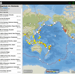
Where can I find current earthquake lists and maps for the world or for a specific area?
The Earthquake Hazards Program Latest Earthquakes Map displays earthquakes in near-realtime and up to the past 30 days of earthquakes. The interface includes three panels: a list of earthquakes, a map, and a settings/options panel. You can pan and zoom the map to view specific areas. Click on an event on the list or map for additional information and a link to the event page with all the details...
Did I feel an earthquake? Can I report feeling an earthquake?
Report an earthquake experience or related observation through the Did You Feel It? citizen science webpage. The best way to do this is to click on the earthquake that you think you felt on one of the lists on the Earthquakes webpage, and then select the "Tell Us!" link. If you don't see the earthquake you think you felt, use the green "Report an Unknown Event" button on our Did You Feel It? page...
Why is the earthquake that was reported/recorded by network X, or that I felt, not on the Latest Earthquakes map/list?
The USGS Latest Earthquakes map and lists show events that have been located by the USGS and contributing agencies within the last 30 days. They should NOT be considered complete lists of all events in the U.S. and adjacent areas and especially should NOT be considered complete lists of all magnitude 4.5 and greater events that occur around the globe. In most cases, we locate and report an...
Why isn't the fault on which the earthquake occurred or the distance to the nearest fault provided?
Seismologists evaluate the hypocenter location and the focal mechanism of an earthquake to decide if the earthquake occurs on a named fault. Research shows that many earthquakes occur on small, un-named faults located near well-known faults. For example, most of the aftershocks of the 1989 M6.9 Loma Prieta earthquake occurred on small, subsidiary faults within a few hundred meters of the mainshock...
Can I get on a list to receive an email message when there is an earthquake? How do I sign up for earthquake notifications? Are there any Feeds I can subscribe to?
Please go to the USGS Earthquake Notification Services (ENS) to sign up for free emails or text messages to your phone. Use the default settings or customize ENS to fit your needs. Also check out the many different Earthquake Feeds. ENS is NOT an earthquake early warning system. Messages issued by ENS will almost always arrive after you would feel any shaking. Learn more: How do I sign up for...
Why/When does the USGS update the magnitude of an earthquake?
The USGS often updates an earthquake's magnitude in the hours and sometimes days following the event. Updates occur as more data become available for analysis and more time-intensive analysis is performed. Additional updates are possible as part of the standard procedure of assembling a final earthquake catalog. There are physical and operational constraints on how quickly seismic data are...
Why do so many earthquakes occur at a depth of 10km?
Ten kilometers is a "fixed depth". Sometimes data are too poor to compute a reliable depth for an earthquake. In such cases, the depth is assigned to be 10 km. Why that number? In many areas around the world, reliable depths tend to average 10 km or close to it. For example, if we made a histogram of the reliable depths in such an area, we'd expect to see a peak around 10 km. So if we don't know...
How quickly is earthquake information posted to the USGS website and sent out via the Earthquake Notification Service (ENS) and other feeds?
USGS earthquake information mechanisms are all triggered by the same system, so they all receive the information at the same time. The time it takes for the system to receive the information primarily depends on the size and location of the earthquake: An earthquake in California is processed and posted to the system in 2.5 minutes (on average). This is because our seismic network is very...
Where can I see current or past seismograms?
The USGS Earthquake Hazards Program has helicorders (seismogram displays) available for several areas in the United States and the World. Our research partner IRIS (Incorporated Research Institutions for Seismology) has two applications, the Station Monitor and the Global Seismogram Viewer, for viewing seismograms. IRIS also supplies software that allows users to collect and view seismic data from...
Why do USGS earthquake magnitudes differ from those published by other agencies?
Magnitude estimates for a given earthquake can vary between reporting agencies due to differences in methodology, data availability, and inherent uncertainties in seismic data. Individual agencies use magnitude estimation procedures designed to meet the agency's specific needs and monitoring capabilities. Even for well-recorded events, differences in magnitude of 0.2 or 0.3 units are common and...
What is UTC, and why do you report earthquakes in UTC?
UTC stands for Coordinated Universal Time, and for this purpose is the same as GMT (Greenwich Mean Time). Since the USGS and other seismic network agencies record earthquakes around the globe in all the various time zones, using a single standard time reference is best for record-keeping and exchange of data. The individual event pages with details about each earthquake use UTC for the reference...

Map of earthquakes in the Yellowstone National Park region in 2023
Map of seismicity (red circles) in the Yellowstone region during 2023. Gray lines are roads, black dashed line shows the caldera boundary, Yellowstone National Park is outlined by black dot-dashed line, and gray dashed lines denote state boundaries.

PubTalk 5/2021 - Where Earthquakes Hide in the Desert
Title: Where Earthquakes Hide in the Desert: What we've learned from recent fault ruptures in the western U.S.
By Austin J. Elliott, USGS Research Geologist
Title: Where Earthquakes Hide in the Desert: What we've learned from recent fault ruptures in the western U.S.
By Austin J. Elliott, USGS Research Geologist

Earthquake hazard map showing peak ground accelerations having a 2 percent proba
Earthquake hazard map showing peak ground accelerations having a 2 percent probability of being exceeded in 50 years, for a firm rock site. Black box outlines Yellowstone region. The map is based on the most recent USGS models for the conterminous U.S. (2018), Hawaii (1998), and Alaska (2007).
Earthquake hazard map showing peak ground accelerations having a 2 percent probability of being exceeded in 50 years, for a firm rock site. Black box outlines Yellowstone region. The map is based on the most recent USGS models for the conterminous U.S. (2018), Hawaii (1998), and Alaska (2007).

HayWired scenario earthquake map
HayWIred scenario earthquake map.
HayWIred scenario earthquake map.

PubTalk 9/2018 - Hayward Earthquake
Title: The 150th Anniversary of the Damaging 1868 Hayward Earthquake: Why It Matters and How We Can Prepare for Its Repeat
Title: The 150th Anniversary of the Damaging 1868 Hayward Earthquake: Why It Matters and How We Can Prepare for Its Repeat

Examples of seismograms of different types of earthquakes and tremo...
Examples of seismograms of different types of earthquakes and tremor (constant ground shaking) recorded in Hawai‘i.
Examples of seismograms of different types of earthquakes and tremor (constant ground shaking) recorded in Hawai‘i.
Related
Where can I find current earthquake lists and maps for the world or for a specific area?
The Earthquake Hazards Program Latest Earthquakes Map displays earthquakes in near-realtime and up to the past 30 days of earthquakes. The interface includes three panels: a list of earthquakes, a map, and a settings/options panel. You can pan and zoom the map to view specific areas. Click on an event on the list or map for additional information and a link to the event page with all the details...
Did I feel an earthquake? Can I report feeling an earthquake?
Report an earthquake experience or related observation through the Did You Feel It? citizen science webpage. The best way to do this is to click on the earthquake that you think you felt on one of the lists on the Earthquakes webpage, and then select the "Tell Us!" link. If you don't see the earthquake you think you felt, use the green "Report an Unknown Event" button on our Did You Feel It? page...
Why is the earthquake that was reported/recorded by network X, or that I felt, not on the Latest Earthquakes map/list?
The USGS Latest Earthquakes map and lists show events that have been located by the USGS and contributing agencies within the last 30 days. They should NOT be considered complete lists of all events in the U.S. and adjacent areas and especially should NOT be considered complete lists of all magnitude 4.5 and greater events that occur around the globe. In most cases, we locate and report an...
Why isn't the fault on which the earthquake occurred or the distance to the nearest fault provided?
Seismologists evaluate the hypocenter location and the focal mechanism of an earthquake to decide if the earthquake occurs on a named fault. Research shows that many earthquakes occur on small, un-named faults located near well-known faults. For example, most of the aftershocks of the 1989 M6.9 Loma Prieta earthquake occurred on small, subsidiary faults within a few hundred meters of the mainshock...
Can I get on a list to receive an email message when there is an earthquake? How do I sign up for earthquake notifications? Are there any Feeds I can subscribe to?
Please go to the USGS Earthquake Notification Services (ENS) to sign up for free emails or text messages to your phone. Use the default settings or customize ENS to fit your needs. Also check out the many different Earthquake Feeds. ENS is NOT an earthquake early warning system. Messages issued by ENS will almost always arrive after you would feel any shaking. Learn more: How do I sign up for...
Why/When does the USGS update the magnitude of an earthquake?
The USGS often updates an earthquake's magnitude in the hours and sometimes days following the event. Updates occur as more data become available for analysis and more time-intensive analysis is performed. Additional updates are possible as part of the standard procedure of assembling a final earthquake catalog. There are physical and operational constraints on how quickly seismic data are...
Why do so many earthquakes occur at a depth of 10km?
Ten kilometers is a "fixed depth". Sometimes data are too poor to compute a reliable depth for an earthquake. In such cases, the depth is assigned to be 10 km. Why that number? In many areas around the world, reliable depths tend to average 10 km or close to it. For example, if we made a histogram of the reliable depths in such an area, we'd expect to see a peak around 10 km. So if we don't know...
How quickly is earthquake information posted to the USGS website and sent out via the Earthquake Notification Service (ENS) and other feeds?
USGS earthquake information mechanisms are all triggered by the same system, so they all receive the information at the same time. The time it takes for the system to receive the information primarily depends on the size and location of the earthquake: An earthquake in California is processed and posted to the system in 2.5 minutes (on average). This is because our seismic network is very...
Where can I see current or past seismograms?
The USGS Earthquake Hazards Program has helicorders (seismogram displays) available for several areas in the United States and the World. Our research partner IRIS (Incorporated Research Institutions for Seismology) has two applications, the Station Monitor and the Global Seismogram Viewer, for viewing seismograms. IRIS also supplies software that allows users to collect and view seismic data from...
Why do USGS earthquake magnitudes differ from those published by other agencies?
Magnitude estimates for a given earthquake can vary between reporting agencies due to differences in methodology, data availability, and inherent uncertainties in seismic data. Individual agencies use magnitude estimation procedures designed to meet the agency's specific needs and monitoring capabilities. Even for well-recorded events, differences in magnitude of 0.2 or 0.3 units are common and...
What is UTC, and why do you report earthquakes in UTC?
UTC stands for Coordinated Universal Time, and for this purpose is the same as GMT (Greenwich Mean Time). Since the USGS and other seismic network agencies record earthquakes around the globe in all the various time zones, using a single standard time reference is best for record-keeping and exchange of data. The individual event pages with details about each earthquake use UTC for the reference...
Map of earthquakes in the Yellowstone National Park region in 2023
Map of seismicity (red circles) in the Yellowstone region during 2023. Gray lines are roads, black dashed line shows the caldera boundary, Yellowstone National Park is outlined by black dot-dashed line, and gray dashed lines denote state boundaries.
Map of seismicity (red circles) in the Yellowstone region during 2023. Gray lines are roads, black dashed line shows the caldera boundary, Yellowstone National Park is outlined by black dot-dashed line, and gray dashed lines denote state boundaries.
PubTalk 5/2021 - Where Earthquakes Hide in the Desert
Title: Where Earthquakes Hide in the Desert: What we've learned from recent fault ruptures in the western U.S.
By Austin J. Elliott, USGS Research Geologist
Title: Where Earthquakes Hide in the Desert: What we've learned from recent fault ruptures in the western U.S.
By Austin J. Elliott, USGS Research Geologist
Earthquake hazard map showing peak ground accelerations having a 2 percent proba
Earthquake hazard map showing peak ground accelerations having a 2 percent probability of being exceeded in 50 years, for a firm rock site. Black box outlines Yellowstone region. The map is based on the most recent USGS models for the conterminous U.S. (2018), Hawaii (1998), and Alaska (2007).
Earthquake hazard map showing peak ground accelerations having a 2 percent probability of being exceeded in 50 years, for a firm rock site. Black box outlines Yellowstone region. The map is based on the most recent USGS models for the conterminous U.S. (2018), Hawaii (1998), and Alaska (2007).
HayWired scenario earthquake map
HayWIred scenario earthquake map.
HayWIred scenario earthquake map.
PubTalk 9/2018 - Hayward Earthquake
Title: The 150th Anniversary of the Damaging 1868 Hayward Earthquake: Why It Matters and How We Can Prepare for Its Repeat
Title: The 150th Anniversary of the Damaging 1868 Hayward Earthquake: Why It Matters and How We Can Prepare for Its Repeat
Examples of seismograms of different types of earthquakes and tremo...
Examples of seismograms of different types of earthquakes and tremor (constant ground shaking) recorded in Hawai‘i.
Examples of seismograms of different types of earthquakes and tremor (constant ground shaking) recorded in Hawai‘i.
Updated Date: September 10, 2024