
Members of the LANDFIRE team met in March of 2019 at the USGS Earth Resources Observation and Science (EROS) Center near Sioux Falls, SD.
Images
Peruse our selection of remote sensing and Earth science imagery below.
Filter Total Items: 663

LANDFIRE Team - 2019
Members of the LANDFIRE team met in March of 2019 at the USGS Earth Resources Observation and Science (EROS) Center near Sioux Falls, SD.

Kandahar - March 3, 2019
Landsat 8 image of Kandahar, Afghanistan on March 3, 2019, rendered with bands 7, 5, and 1 of the satellite's Operational Land Imager.
Landsat 8 image of Kandahar, Afghanistan on March 3, 2019, rendered with bands 7, 5, and 1 of the satellite's Operational Land Imager.

Fanned Out
Water from the Balkh River fans out into an agricultural area toward an arid region in northern Afghanistan, near the border with Uzbekistan and Turkmenistan. Part of an ancient region called Bactria, extensive irrigation produces melons, almonds, apricots, and grains. Mazar-e Sharif is the urban area that dominates the lower right corner of the image.
Water from the Balkh River fans out into an agricultural area toward an arid region in northern Afghanistan, near the border with Uzbekistan and Turkmenistan. Part of an ancient region called Bactria, extensive irrigation produces melons, almonds, apricots, and grains. Mazar-e Sharif is the urban area that dominates the lower right corner of the image.

Deep Blue Cubism
A bit of blue cubism in southern Uzbekistan highlights the intensive irrigation that is common along rivers that flow into the Aral Sea. However, so much water is used for irrigation that very little actually reaches the Aral Sea.
A bit of blue cubism in southern Uzbekistan highlights the intensive irrigation that is common along rivers that flow into the Aral Sea. However, so much water is used for irrigation that very little actually reaches the Aral Sea.

USGS EROS Researchers in Idaho
USGS EROS contractor Minsu Kim, left, and USGS Scientist Jeffrey Danielson stand with a GPS device in northern Idaho, where they were part of a research project to conduct topobathymetric research along the Kootenai River of northern Idaho.
USGS EROS contractor Minsu Kim, left, and USGS Scientist Jeffrey Danielson stand with a GPS device in northern Idaho, where they were part of a research project to conduct topobathymetric research along the Kootenai River of northern Idaho.

Irritated
This natural landscape might appear more like a medical illustration of itchy nerve endings. In Western Sahara, Africa, an intense network of wadis drains toward the west, eventually reaching the Atlantic Ocean. These drainage courses are almost always dry in this remote part of the Sahara Desert.
This natural landscape might appear more like a medical illustration of itchy nerve endings. In Western Sahara, Africa, an intense network of wadis drains toward the west, eventually reaching the Atlantic Ocean. These drainage courses are almost always dry in this remote part of the Sahara Desert.

Desert Ribbons
Rock folding on a tectonic scale occurred in northwestern Africa. These motley ribbons dancing across the desert in Morocco are folds caused by the prolonged collision of tectonic plates. The long continuous line is Jbel Ouarkziz, a ridge that rises 200–300 meters above the valley floors.
Rock folding on a tectonic scale occurred in northwestern Africa. These motley ribbons dancing across the desert in Morocco are folds caused by the prolonged collision of tectonic plates. The long continuous line is Jbel Ouarkziz, a ridge that rises 200–300 meters above the valley floors.

San Carlos Apache Reservation Drought Research
(A) The Creek Fire perimeter within the San Carlos Apache Reservation in east-central Arizona and (B) the various fuel treatments within the Creek Fire boundary, using the boundary in Wu et al.
(A) The Creek Fire perimeter within the San Carlos Apache Reservation in east-central Arizona and (B) the various fuel treatments within the Creek Fire boundary, using the boundary in Wu et al.

New Jersey Landsat State Mosaic
Modern paleontology began with the 1858 discovery by William Parker Foulke at Haddonfield, New Jersey of the nearly complete skeleton of a dinosaur called Hadrosaurus.
Capital Trenton
Image Source Landsat 8
Population 9,288,994
Modern paleontology began with the 1858 discovery by William Parker Foulke at Haddonfield, New Jersey of the nearly complete skeleton of a dinosaur called Hadrosaurus.
Capital Trenton
Image Source Landsat 8
Population 9,288,994

Ohio Landsat State Mosaic
Did you know that nearly 50 percent of the United States population lives within a 500-mile radius of Columbus, Ohio? Columbus is the state capital and Ohio’s largest city. It is also home to The Ohio State University.
Capital Columbus
Image Source Landsat 8
Did you know that nearly 50 percent of the United States population lives within a 500-mile radius of Columbus, Ohio? Columbus is the state capital and Ohio’s largest city. It is also home to The Ohio State University.
Capital Columbus
Image Source Landsat 8

Texas Landsat State Mosaid
Six flags have flown over Texas: Spain, France, United Mexican States, Confederate States of America, the Republic of Texas, and the United States of America, with eight changes of government.
Capital Austin
Image Source Landsat 8
Population 29,145,505
Six flags have flown over Texas: Spain, France, United Mexican States, Confederate States of America, the Republic of Texas, and the United States of America, with eight changes of government.
Capital Austin
Image Source Landsat 8
Population 29,145,505

Map of AK showing probability of change occurrence
Map of Alaska showing probability (%) of change occurrence. Insets show fire boundaries from the Bureau of Land Management (BLM) Large Fire Database and Landsat 8 imagery (bottom right; 2016) north of Fairbanks, Alaska.
Map of Alaska showing probability (%) of change occurrence. Insets show fire boundaries from the Bureau of Land Management (BLM) Large Fire Database and Landsat 8 imagery (bottom right; 2016) north of Fairbanks, Alaska.

Land Change in the Black Hills - LCMAP
Animation of land cover change in the Black Hills, created using Land Change Monitoring, Assessment, and Projection data from the USGS Earth Resources Observation and Science (EROS) Center.
Animation of land cover change in the Black Hills, created using Land Change Monitoring, Assessment, and Projection data from the USGS Earth Resources Observation and Science (EROS) Center.

Twelvemile Lake - Change Over Time
Animation of Twelvemile Lake in the Yukon Flats ecoregion in Alaska, created using USGS Landsat data.
Animation of Twelvemile Lake in the Yukon Flats ecoregion in Alaska, created using USGS Landsat data.

LCMAP animation - solar farm
An animation of the growth of a solar farm, created using Land Change Monitoring, Assessment, and Projection data.
An animation of the growth of a solar farm, created using Land Change Monitoring, Assessment, and Projection data.

Landsat image of center pivot irrigation fields in the Arabian Desert
Center pivot irrigation fields in the Arabian Desert are visible in this Landsat 8 image near Meegowa, Saudi Arabia. The image was acquired on Oct 10, 2018 and is shown in a color infrared band combination (Bands 5,4,3).
Center pivot irrigation fields in the Arabian Desert are visible in this Landsat 8 image near Meegowa, Saudi Arabia. The image was acquired on Oct 10, 2018 and is shown in a color infrared band combination (Bands 5,4,3).
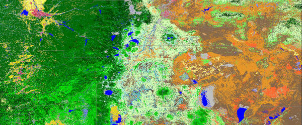
LANDFIRE- Landscape Fire and Resource Management Planning Tools
LANDFIRE Existing Vegetation Type imagery.
LANDFIRE Existing Vegetation Type imagery.

Fire Potential Index (FPI) forecast
The FPI is most similar to the Energy Release Component of the National Fire Danger Rating System in that both are moisture related indexes and neither indicates the effect of wind on fire potential.
The FPI is most similar to the Energy Release Component of the National Fire Danger Rating System in that both are moisture related indexes and neither indicates the effect of wind on fire potential.

MacDonnell Ranges
The MacDonnell Ranges are a band of mountains spanning Australia's arid interior. Only a portion of the Ranges can be seen in this image.
The MacDonnell Ranges are a band of mountains spanning Australia's arid interior. Only a portion of the Ranges can be seen in this image.

Africa
Africa, the second largest continent, is a mix of steamy rainforests, vast grasslands, and arid deserts. It has no long mountain ranges, but is home to the world's largest hot desert, the Sahara, and its longest river, the Nile. The featured area is the central South Atlantic coastal region of Namibia, including the cities of Walvis Bay and Windhoek.
Africa, the second largest continent, is a mix of steamy rainforests, vast grasslands, and arid deserts. It has no long mountain ranges, but is home to the world's largest hot desert, the Sahara, and its longest river, the Nile. The featured area is the central South Atlantic coastal region of Namibia, including the cities of Walvis Bay and Windhoek.

Colima Volcano
Snow-capped Colima Volcano, the most active volcano in Mexico, rises abruptly from the surrounding landscape in the state of Jalisco. Colima is actually a melding of two volcanoes, the older Nevado de Colima to the north and the younger, historically active Volcan de Colima to the south. Legend has it that gods sit atop the volcano on thrones of fire and ice.
Snow-capped Colima Volcano, the most active volcano in Mexico, rises abruptly from the surrounding landscape in the state of Jalisco. Colima is actually a melding of two volcanoes, the older Nevado de Colima to the north and the younger, historically active Volcan de Colima to the south. Legend has it that gods sit atop the volcano on thrones of fire and ice.