
Using Google Earth Engine and Landsat, this team created a rapid and robust tool for mapping historical flood inundation areas. This enhances existing efforts towards flood mitigation, monitoring, and management.
Images
Peruse our selection of remote sensing and Earth science imagery below.
Filter Total Items: 663

Mapping of Flood Areas Using Landsat with Google Earth Engine Cloud Platform
Using Google Earth Engine and Landsat, this team created a rapid and robust tool for mapping historical flood inundation areas. This enhances existing efforts towards flood mitigation, monitoring, and management.

First Experiences with the Collection 1 Landsat 8 Aquatic Reflectance Product

Landsat Collections Screenshot
This screenshot shows what the Landsat Collections interactive looks like. This storymap collection combines all of the individual satellite storymaps into one location.
This screenshot shows what the Landsat Collections interactive looks like. This storymap collection combines all of the individual satellite storymaps into one location.

Landsat 9 First Light Images
Landsat 9 launched into space on September 27th, 2021. The "first light" images arrived on October 31st. On that day the satellite captured: algal blooms in Lake Erie, the glaciers of the Himalayas, bush fires in Australia's Eucalypt Woodlands, coastal communities on the Florida panhandle, and deserts, mountains and mesas across the Navajo Nation.
Landsat 9 launched into space on September 27th, 2021. The "first light" images arrived on October 31st. On that day the satellite captured: algal blooms in Lake Erie, the glaciers of the Himalayas, bush fires in Australia's Eucalypt Woodlands, coastal communities on the Florida panhandle, and deserts, mountains and mesas across the Navajo Nation.

Landsat 8 Thermal Infrared Sensor Image near Ogallala, Nebraska
Landsat 8 thermal infrared (Band 10) image near Ogallala, Nebraska, showing fields with center pivot irrigation. The Thermal Infrared Sensor (TIRS) on Landsat 8-9 measures energy radiated by the earth of the surface with two spectral bands that can be used to derive surface temperature.
The image was acquired on August 17, 2021 from Path 31 Row 32.

How Do You Landsat Overfly
An optimal opportunity for in-flight cross-calibration occurred when Landsat 9 flew underneath Landsat 8 while moving into its final orbit. Since the two satellites nearly identical imaging systems, the underfly event offered ideal cross-calibration conditions.
An optimal opportunity for in-flight cross-calibration occurred when Landsat 9 flew underneath Landsat 8 while moving into its final orbit. Since the two satellites nearly identical imaging systems, the underfly event offered ideal cross-calibration conditions.

Latest in Landsat June Newsletter
In this June 2022 issue read highlights from an international partner meeting, explore published Landsat articles, and dive into new interactive tools. Find the newsletter here: https://www.usgs.gov/latest-landsat-newsletter/latest-landsat-newslette…
In this June 2022 issue read highlights from an international partner meeting, explore published Landsat articles, and dive into new interactive tools. Find the newsletter here: https://www.usgs.gov/latest-landsat-newsletter/latest-landsat-newslette…

EoE - EMIT Mission homepage
Clockwise from lower left: Phil Brodrick, Raymond Kokaly, David Thompson of the EMIT Science Team, pictured with the logo for the USGS EROS Center podcast “Eyes on Earth.”
Clockwise from lower left: Phil Brodrick, Raymond Kokaly, David Thompson of the EMIT Science Team, pictured with the logo for the USGS EROS Center podcast “Eyes on Earth.”

Landsat: Celebrating 50 Years
Thumbnail for USGS Earth Resources Observation and Science (EROS) Center video "Landsat: Celebrating 50 Years."
Thumbnail for USGS Earth Resources Observation and Science (EROS) Center video "Landsat: Celebrating 50 Years."

Attendees of the Landsat Ground Station Operators Working Group (LGSOWG) #50 meeting
Attendees of the Landsat Ground Station Operators Working Group (LGSOWG) #50 meeting. The meeting was held in Pretoria, South Africa during the first week of May, 2022.
For more information on the Landsat International Cooperator Network, visit https://landsat.usgs.gov/igs-network/
Attendees of the Landsat Ground Station Operators Working Group (LGSOWG) #50 meeting. The meeting was held in Pretoria, South Africa during the first week of May, 2022.
For more information on the Landsat International Cooperator Network, visit https://landsat.usgs.gov/igs-network/

Earthshots Image
Image featuring Earthshot cards that are used for outreach purposes. Earthshots can be viewed digitally here: https://eros.usgs.gov/image-gallery/earthshots.
Image featuring Earthshot cards that are used for outreach purposes. Earthshots can be viewed digitally here: https://eros.usgs.gov/image-gallery/earthshots.

Landsat 8 image of Karymsky volcano, April 20, 2022
Karymsky volcano, one of the most active volcanoes of Kamchatka's eastern volcanic zone, erupted on April 20, 2022. This pan-sharpened Landsat 8 image captured the event. Overlaying the infrared data over the natural color image highlights the heat signature of the active flows.
Landsat ID: LC08_L1TP_098022_20220420_20220420_02_RT

HDYL Great Barrier Reef
The largest coral reef ecosystem in the world, the Great Barrier Reef (GBR), is threatened by many human-made impacts. Due to the size of the GBR and limited accessibility, mapping and monitoring has always been a challenging task. Remote Sensing is an effective technique that provides valuable information for the GBR ecosystem.
The largest coral reef ecosystem in the world, the Great Barrier Reef (GBR), is threatened by many human-made impacts. Due to the size of the GBR and limited accessibility, mapping and monitoring has always been a challenging task. Remote Sensing is an effective technique that provides valuable information for the GBR ecosystem.

HDYL Boreal Forest Biome
The boreal forest biome is projected to shift northward due to continued climate change over the coming century. Researchers evaluated early indicators of a boreal forest biome shift using four decades of Landsat observation datasets.
The boreal forest biome is projected to shift northward due to continued climate change over the coming century. Researchers evaluated early indicators of a boreal forest biome shift using four decades of Landsat observation datasets.

Landsat Update March 2022
The latest Landsat Update is available for the public. Text on image reads: "Landsat Update: March 2022. Learn the latest Landsat information and news. What's inside? Pecora 22 upcoming meeting, Landsat 9 mission status, Landsat 9 data available, Collection 2 Level 3 products available, Archive reaches 10 million scenes, Landsat Science Team meeting.
The latest Landsat Update is available for the public. Text on image reads: "Landsat Update: March 2022. Learn the latest Landsat information and news. What's inside? Pecora 22 upcoming meeting, Landsat 9 mission status, Landsat 9 data available, Collection 2 Level 3 products available, Archive reaches 10 million scenes, Landsat Science Team meeting.

February Landsat Social Media Posts
Social media posts from February for the March 2022 Landsat Update. Available via Landsat Missions.
Social media posts from February for the March 2022 Landsat Update. Available via Landsat Missions.

PECORA award
Pecora 2022 award flyer announcing call for nominations, due April 15, 2022.
Pecora 2022 award flyer announcing call for nominations, due April 15, 2022.

Fire near Uljin-eup, South Korea (Natural Color)
Landsat 9 captured this natural color image of the ongoing fire in Uljin county on South Korea’s west coast.
Landsat 9 captured this natural color image of the ongoing fire in Uljin county on South Korea’s west coast.

Fire near Uljin-eup, South Korea (False Color)
Landsat 9 captured an image of the ongoing fire in Uljin county on South Korea’s west coast. The false color image looks beneath the smoke and shows the burn scar as reddish-brown and the heat signature from the fire as bright red.
Landsat 9 captured an image of the ongoing fire in Uljin county on South Korea’s west coast. The false color image looks beneath the smoke and shows the burn scar as reddish-brown and the heat signature from the fire as bright red.
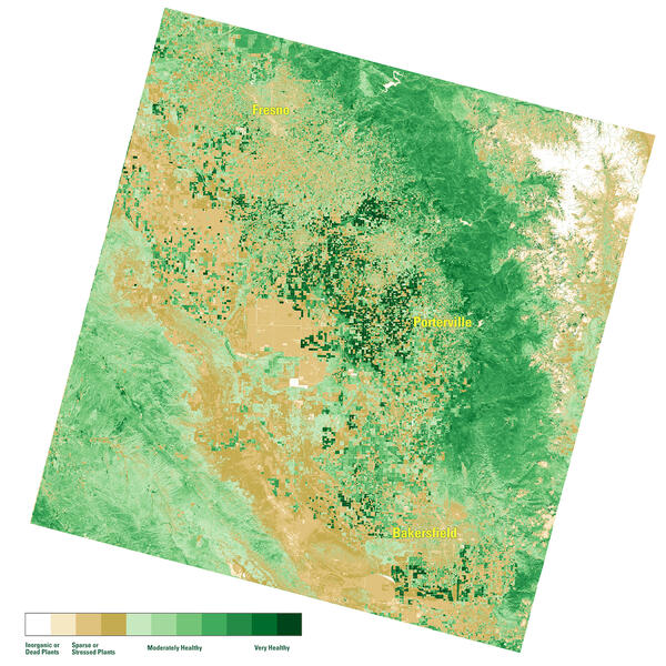
NDVI map of the San Joaquin Valley Region, March 10, 2022
A Landsat Surface Reflectance (SR) Normalized Difference Index (NDVI) map of the San Joaquin Valley region of California on March 10, 2022.
A Landsat Surface Reflectance (SR) Normalized Difference Index (NDVI) map of the San Joaquin Valley region of California on March 10, 2022.
Landsat Science Team Meeting Presentations Available
The Landsat Science Team met virtually on February 9, 2022. Topics included, but were not limited to, Landsat 9 operations, calibration, and data release plans; Landsat 7 mission status; Landsat and Sentinel harmonization; and the future of land imaging.
The Landsat Science Team met virtually on February 9, 2022. Topics included, but were not limited to, Landsat 9 operations, calibration, and data release plans; Landsat 7 mission status; Landsat and Sentinel harmonization; and the future of land imaging.