

Zoomed in image of Annual NLCD Land Cover in 1985 compared to the same area in 2023 for Silverdale, WA. Annual NLCD Land Cover science product represents the most likely thematic land cover type of the Anderson Level II classes. Notice the increase in development (shown in red) and the changed in forest in the west.
Annual National Land Cover Database
Active
By Earth Resources Observation and Science (EROS) Center
September 26, 2024
About Annual NLCD
Product Suite
Data Access
Reference and Validation
Notice to users: The Annual NLCD product release is planned for late October 2024. At that time further content, such as product documentation and full access to data products, will become available and referenced from this site.
Annual NLCD Product Suite
Annual NLCD Product Suite

Annual NLCD offers a suite of six annual land use and land cover change in the conterminous United States. Annual NLCD Collection 1.0 is available in Fall 2024.
Data Access
Data Access

Annual NLCD Science Products are available for download from a variety of data download portals.
Land cover is foundational information for land managers, scientists, and the general public. Many types of scientific studies have applied annual land cover information including estimating biological carbon emissions, projecting future land use, tracking urban development and heat island effects, documenting forest fragmentation or conservation practices, modeling wildfire hazards, tracking water quality and quantity, and understanding change in wildlife habitat and ecosystem disturbance/disease.
The Annual National Land Cover Database (NLCD) has harnessed the full Landsat data record to provide timely, long-term, and detailed land surface change information. Annual NLCD uses an ensemble of classification and change algorithms to map, monitor, and synthesize the complexities of land use, cover, and condition change through time. The Annual NLCD product suite offers data that describe nationwide land cover and land change over nearly four decades. A new generation of USGS Land Cover mapping, introduced in the Annual NLCD Collection 1 release, leverages advancements in artificial intelligence and machine learning techniques and runs within high-performance computing and cloud processing environments.

Sources/Usage: Public Domain. View Media Details
About Annual NLCD
About Annual NLCD
Annual NLCD is a new generation of land cover mapping that offers annual land cover and land change science products nationwide with nearly four decades of data. Click on the link below to learn more about Annual NLCD.
Annual NLCD Science Products
Annual NLCD Science Products
Annual NLCD project has generated a product suite of six geospatial raster land use and land cover science products for the conterminous United States ranging from 1985-2023. There will be annual release of NLCD science products. Check out the Science Product User Guide for in-depth information about Annual NLCD.
Data Access
Data Access
A suite of six annual integrated land cover and land surface change products are available for the conterminous United States. Products for Alaska and Hawaii are planned. The product suite provides powerful time-series information at a 30-m spatial resolution about annual land cover and its change across time. Products can be accessed via the data access page.
Reference and Validation
Reference and Validation
Validation of land cover and land cover change information is essential for providing authoritative products to our user community. Validation reports provide estimates of the accuracies and uncertainties of the NLCD land cover products and are derived from well-documented independent reference data. Processing flows, product specifications, uncertainties and known issues are published in validation reports to ensure consistency. See the Reference and Validation products page for more information.
Science Product User Guide
Science Product User Guide
Additional information on Annual NLCD and Annual NLCD science products can be found in the Science User Product Guide. The Science User Product Guide contains in-depth information about Annual NLCD including characteristics of the science products, algorithm description, and accuracy assessment.
Citation
U.S. Geological Survey (USGS), 2024, Annual NLCD Collection 1 Science Products: U.S. Geological Survey data release, https://doi.org/10.5066/P94UXNTS

Annual NLCD Collection 1.0 (2023) for CONUS
The Annual NLCD product suite offers six different land use and land cover products. The Annual NLCD Land Cover product depicts the predominant thematic land cover of 16 Anderson Level II classes within the current mapping year. The Annual NLCD Land Cover of the conterminous United States shows all Anderson Level II classes.
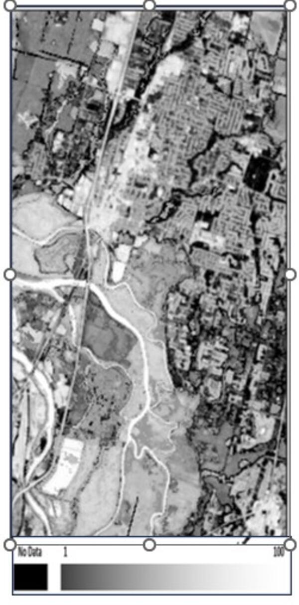
Annual NLCD Landcover in 1985 Compared to 2023
Zoomed in image of Annual NLCD Land Cover in 1985 compared to the same area in 2023 for Silverdale, WA. Annual NLCD Land Cover science product represents the most likely thematic land cover type of the Anderson Level II classes. Notice the increase in development (shown in red) and the changed in forest in the west.

TimeSync Viewer
Annual NLCD Reference and Validation (R&V) program is in the process of collecting an independent reference dataset of 10,000 plots at the Anderson Level II level. The TimeSync tool is used to record attribute information for each plot. On the interface, the drop in NDVI values is noticeable.
Annual NLCD Reference and Validation (R&V) program is in the process of collecting an independent reference dataset of 10,000 plots at the Anderson Level II level. The TimeSync tool is used to record attribute information for each plot. On the interface, the drop in NDVI values is noticeable.

Annual NLCD Spectral Change Day of Year
Depicts the day-of-year (DOY) on which a significant deviation in Landsat surface reflectance was detected within the calendar year.
Depicts the day-of-year (DOY) on which a significant deviation in Landsat surface reflectance was detected within the calendar year.
Annual NLCD Land Cover Confidence Index
Annual NLCD land cover confidence product provides the level of confidence that Annual NLCD land cover class per pixel values that matches the training data.
Annual NLCD land cover confidence product provides the level of confidence that Annual NLCD land cover class per pixel values that matches the training data.

Annual NLCD Land Cover Change Legend
Annual National Land Cover Database (Annual NLCD) land cover legend contains 16 land cover classes based on the Anderson Level II classification system.
Annual National Land Cover Database (Annual NLCD) land cover legend contains 16 land cover classes based on the Anderson Level II classification system.

Annual NLCD Land Cover
Annual NLCD generates a product suite of six land use and land cover themes from 1985-2023. The Annual NLCD Land Cover product Depicts the predominant thematic land cover class within the mapping year with respect to broad categories of artificial or natural surface cover.
Annual NLCD generates a product suite of six land use and land cover themes from 1985-2023. The Annual NLCD Land Cover product Depicts the predominant thematic land cover class within the mapping year with respect to broad categories of artificial or natural surface cover.

Annual NLCD Impervious Descriptor
The Annual National Land Cover Database (NLCD) impervious descriptor product generates a raster layer that differentiates between urban and road surfaces.
The Annual National Land Cover Database (NLCD) impervious descriptor product generates a raster layer that differentiates between urban and road surfaces.

Annual NLCD Fractional Impervious Surface
Depicts the fractional surface area of the map unit (pixel) that is covered with artificial substrate or structures.
Depicts the fractional surface area of the map unit (pixel) that is covered with artificial substrate or structures.

Annual NLCD Land Cover Change
Annual NLCD land cover change product shows the change between the current year’s primary land cover and the prior year’s land cover when there is a change in primary class.
Annual NLCD land cover change product shows the change between the current year’s primary land cover and the prior year’s land cover when there is a change in primary class.

An Annual NLCD Land Cover map centered are around Lake Stevens, WA
An Annual NLCD Land Cover map of centered around Lake Stevens, WA depicting 16 land cover classes.
An Annual NLCD Land Cover map of centered around Lake Stevens, WA depicting 16 land cover classes.

Annual NLCD Collection 1.0
Annual NLCD Collection 1.0 has six different land cover and land use science product that make up the product suite package. The six different Annual NLCD science products are Land Cover, Land Cover Change, Land Cover Confidence Index, Impervious Descriptor, Fractional Impervious Surface, and Spectral Change Day of Year.
Annual NLCD Collection 1.0 has six different land cover and land use science product that make up the product suite package. The six different Annual NLCD science products are Land Cover, Land Cover Change, Land Cover Confidence Index, Impervious Descriptor, Fractional Impervious Surface, and Spectral Change Day of Year.

Land cover change in the northern Dallas-Fort Worth area from 1985-2023 as shown by Annual NLCD Collection 1.0
linkAn animation of land cover change, largely urban growth, in the northern Dallas-Fort Worth, Texas, area from 1985-2023 as shown by Annual NLCD Collection 1.0.
Land cover change in the northern Dallas-Fort Worth area from 1985-2023 as shown by Annual NLCD Collection 1.0
linkAn animation of land cover change, largely urban growth, in the northern Dallas-Fort Worth, Texas, area from 1985-2023 as shown by Annual NLCD Collection 1.0.

NLCD 2023 Sneak Peek!
Based on Landsat Collection 2, NLCD 2023 will offer annual products from 1985 – 2023. Depicting urban growth for the Atlanta area, this animation shows a single Landsat U.S. ARD tile of Anderson Level II land cover classification generated from the latest prototypes.
Based on Landsat Collection 2, NLCD 2023 will offer annual products from 1985 – 2023. Depicting urban growth for the Atlanta area, this animation shows a single Landsat U.S. ARD tile of Anderson Level II land cover classification generated from the latest prototypes.

30 Years of the National Land Cover Database (NLCD)
30 Years of the National Land Cover Database (NLCD)
The NLCD stands as the definitive land cover database for the United States
30 Years of the National Land Cover Database (NLCD)
The NLCD stands as the definitive land cover database for the United States
Notice to users: The Annual NLCD product release is planned for late October 2024. At that time further content, such as product documentation and full access to data products, will become available and referenced from this site.
Annual NLCD Product Suite
Annual NLCD Product Suite
Annual NLCD offers a suite of six annual land use and land cover change in the conterminous United States. Annual NLCD Collection 1.0 is available in Fall 2024.
Data Access
Data Access
Annual NLCD Science Products are available for download from a variety of data download portals.
Land cover is foundational information for land managers, scientists, and the general public. Many types of scientific studies have applied annual land cover information including estimating biological carbon emissions, projecting future land use, tracking urban development and heat island effects, documenting forest fragmentation or conservation practices, modeling wildfire hazards, tracking water quality and quantity, and understanding change in wildlife habitat and ecosystem disturbance/disease.
The Annual National Land Cover Database (NLCD) has harnessed the full Landsat data record to provide timely, long-term, and detailed land surface change information. Annual NLCD uses an ensemble of classification and change algorithms to map, monitor, and synthesize the complexities of land use, cover, and condition change through time. The Annual NLCD product suite offers data that describe nationwide land cover and land change over nearly four decades. A new generation of USGS Land Cover mapping, introduced in the Annual NLCD Collection 1 release, leverages advancements in artificial intelligence and machine learning techniques and runs within high-performance computing and cloud processing environments.
Sources/Usage: Public Domain. View Media Details
About Annual NLCD
About Annual NLCD
Annual NLCD is a new generation of land cover mapping that offers annual land cover and land change science products nationwide with nearly four decades of data. Click on the link below to learn more about Annual NLCD.
Annual NLCD Science Products
Annual NLCD Science Products
Annual NLCD project has generated a product suite of six geospatial raster land use and land cover science products for the conterminous United States ranging from 1985-2023. There will be annual release of NLCD science products. Check out the Science Product User Guide for in-depth information about Annual NLCD.
Data Access
Data Access
A suite of six annual integrated land cover and land surface change products are available for the conterminous United States. Products for Alaska and Hawaii are planned. The product suite provides powerful time-series information at a 30-m spatial resolution about annual land cover and its change across time. Products can be accessed via the data access page.
Reference and Validation
Reference and Validation
Validation of land cover and land cover change information is essential for providing authoritative products to our user community. Validation reports provide estimates of the accuracies and uncertainties of the NLCD land cover products and are derived from well-documented independent reference data. Processing flows, product specifications, uncertainties and known issues are published in validation reports to ensure consistency. See the Reference and Validation products page for more information.
Science Product User Guide
Science Product User Guide
Additional information on Annual NLCD and Annual NLCD science products can be found in the Science User Product Guide. The Science User Product Guide contains in-depth information about Annual NLCD including characteristics of the science products, algorithm description, and accuracy assessment.
Citation
U.S. Geological Survey (USGS), 2024, Annual NLCD Collection 1 Science Products: U.S. Geological Survey data release, https://doi.org/10.5066/P94UXNTS
Annual NLCD Collection 1.0 (2023) for CONUS
The Annual NLCD product suite offers six different land use and land cover products. The Annual NLCD Land Cover product depicts the predominant thematic land cover of 16 Anderson Level II classes within the current mapping year. The Annual NLCD Land Cover of the conterminous United States shows all Anderson Level II classes.
Annual NLCD Landcover in 1985 Compared to 2023
Zoomed in image of Annual NLCD Land Cover in 1985 compared to the same area in 2023 for Silverdale, WA. Annual NLCD Land Cover science product represents the most likely thematic land cover type of the Anderson Level II classes. Notice the increase in development (shown in red) and the changed in forest in the west.
Zoomed in image of Annual NLCD Land Cover in 1985 compared to the same area in 2023 for Silverdale, WA. Annual NLCD Land Cover science product represents the most likely thematic land cover type of the Anderson Level II classes. Notice the increase in development (shown in red) and the changed in forest in the west.
TimeSync Viewer
Annual NLCD Reference and Validation (R&V) program is in the process of collecting an independent reference dataset of 10,000 plots at the Anderson Level II level. The TimeSync tool is used to record attribute information for each plot. On the interface, the drop in NDVI values is noticeable.
Annual NLCD Reference and Validation (R&V) program is in the process of collecting an independent reference dataset of 10,000 plots at the Anderson Level II level. The TimeSync tool is used to record attribute information for each plot. On the interface, the drop in NDVI values is noticeable.
Annual NLCD Spectral Change Day of Year
Depicts the day-of-year (DOY) on which a significant deviation in Landsat surface reflectance was detected within the calendar year.
Depicts the day-of-year (DOY) on which a significant deviation in Landsat surface reflectance was detected within the calendar year.
Annual NLCD Land Cover Confidence Index
Annual NLCD land cover confidence product provides the level of confidence that Annual NLCD land cover class per pixel values that matches the training data.
Annual NLCD land cover confidence product provides the level of confidence that Annual NLCD land cover class per pixel values that matches the training data.
Annual NLCD Land Cover Change Legend
Annual National Land Cover Database (Annual NLCD) land cover legend contains 16 land cover classes based on the Anderson Level II classification system.
Annual National Land Cover Database (Annual NLCD) land cover legend contains 16 land cover classes based on the Anderson Level II classification system.
Annual NLCD Land Cover
Annual NLCD generates a product suite of six land use and land cover themes from 1985-2023. The Annual NLCD Land Cover product Depicts the predominant thematic land cover class within the mapping year with respect to broad categories of artificial or natural surface cover.
Annual NLCD generates a product suite of six land use and land cover themes from 1985-2023. The Annual NLCD Land Cover product Depicts the predominant thematic land cover class within the mapping year with respect to broad categories of artificial or natural surface cover.
Annual NLCD Impervious Descriptor
The Annual National Land Cover Database (NLCD) impervious descriptor product generates a raster layer that differentiates between urban and road surfaces.
The Annual National Land Cover Database (NLCD) impervious descriptor product generates a raster layer that differentiates between urban and road surfaces.
Annual NLCD Fractional Impervious Surface
Depicts the fractional surface area of the map unit (pixel) that is covered with artificial substrate or structures.
Depicts the fractional surface area of the map unit (pixel) that is covered with artificial substrate or structures.
Annual NLCD Land Cover Change
Annual NLCD land cover change product shows the change between the current year’s primary land cover and the prior year’s land cover when there is a change in primary class.
Annual NLCD land cover change product shows the change between the current year’s primary land cover and the prior year’s land cover when there is a change in primary class.
An Annual NLCD Land Cover map centered are around Lake Stevens, WA
An Annual NLCD Land Cover map of centered around Lake Stevens, WA depicting 16 land cover classes.
An Annual NLCD Land Cover map of centered around Lake Stevens, WA depicting 16 land cover classes.
Annual NLCD Collection 1.0
Annual NLCD Collection 1.0 has six different land cover and land use science product that make up the product suite package. The six different Annual NLCD science products are Land Cover, Land Cover Change, Land Cover Confidence Index, Impervious Descriptor, Fractional Impervious Surface, and Spectral Change Day of Year.
Annual NLCD Collection 1.0 has six different land cover and land use science product that make up the product suite package. The six different Annual NLCD science products are Land Cover, Land Cover Change, Land Cover Confidence Index, Impervious Descriptor, Fractional Impervious Surface, and Spectral Change Day of Year.
Land cover change in the northern Dallas-Fort Worth area from 1985-2023 as shown by Annual NLCD Collection 1.0
linkAn animation of land cover change, largely urban growth, in the northern Dallas-Fort Worth, Texas, area from 1985-2023 as shown by Annual NLCD Collection 1.0.
Land cover change in the northern Dallas-Fort Worth area from 1985-2023 as shown by Annual NLCD Collection 1.0
linkAn animation of land cover change, largely urban growth, in the northern Dallas-Fort Worth, Texas, area from 1985-2023 as shown by Annual NLCD Collection 1.0.
NLCD 2023 Sneak Peek!
Based on Landsat Collection 2, NLCD 2023 will offer annual products from 1985 – 2023. Depicting urban growth for the Atlanta area, this animation shows a single Landsat U.S. ARD tile of Anderson Level II land cover classification generated from the latest prototypes.
Based on Landsat Collection 2, NLCD 2023 will offer annual products from 1985 – 2023. Depicting urban growth for the Atlanta area, this animation shows a single Landsat U.S. ARD tile of Anderson Level II land cover classification generated from the latest prototypes.
30 Years of the National Land Cover Database (NLCD)
30 Years of the National Land Cover Database (NLCD)
The NLCD stands as the definitive land cover database for the United States
30 Years of the National Land Cover Database (NLCD)
The NLCD stands as the definitive land cover database for the United States