
Northern Rocky Mountain Science Center scientist Zachary Miller conducting routine maintenance on the Garden Wall Weather Station at Glacier National Park, Montana (elevation: 7,400 feet)
Images
Images intro.
Filter Total Items: 416
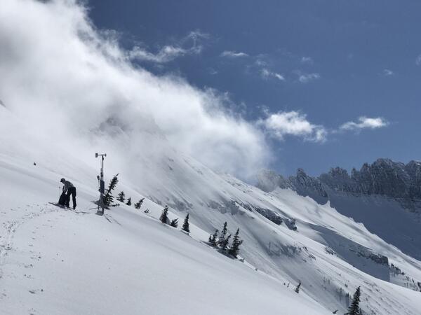
Garden Wall Weather Station maintenance at Glacier National Park
Northern Rocky Mountain Science Center scientist Zachary Miller conducting routine maintenance on the Garden Wall Weather Station at Glacier National Park, Montana (elevation: 7,400 feet)

Salt lick and device to exclude wildlife from access to minerals
Orange and black excluder device (left) will contain minerals, but intended to allow livestock access while excluding wildlife. Mineral block to the right of excluder device.
Orange and black excluder device (left) will contain minerals, but intended to allow livestock access while excluding wildlife. Mineral block to the right of excluder device.

Trout fishing in Montana
Fly fishing for trout in one on Montana's rivers.
Fly fishing for trout in one on Montana's rivers.

Tree-ring sample from an avalanche path
This tree-ring sample from an avalanche path captures 256 years of data between the years 1777 and 2013. The scars in 1818 and 1974 are examples of mechanical damage caused by an avalanche. The pith is the center of the tree.
This tree-ring sample from an avalanche path captures 256 years of data between the years 1777 and 2013. The scars in 1818 and 1974 are examples of mechanical damage caused by an avalanche. The pith is the center of the tree.

Mostly hidden eDNA sampler along Montana stream—arrow shows sampler.
An environmental DNA (eDNA) sampler discretely placed among streamside vegetation at the Flying D Ranch in Montana. An arrow is superimposed on the image to point out the eDNA sampler.
An environmental DNA (eDNA) sampler discretely placed among streamside vegetation at the Flying D Ranch in Montana. An arrow is superimposed on the image to point out the eDNA sampler.

Mostly hidden eDNA sampler along Montana stream
An environmental DNA (eDNA) sampler discretely placed among the vegetation along a stream on the Flying D Ranch in Montana.
An environmental DNA (eDNA) sampler discretely placed among the vegetation along a stream on the Flying D Ranch in Montana.

Grinnell, Gem & Salamander Glaciers in 1910 and 2016
Grinnell, Gem & Salamander Glaciers: 8/9/1910 M Elrod, U of M Library – 9/27/2016 L McKeon, USGS
Grinnell, Gem & Salamander Glaciers: 8/9/1910 M Elrod, U of M Library – 9/27/2016 L McKeon, USGS

Boulder Glacier in 1910 and 2007
Boulder Glacier: circa 1910 M Elrod, Glacier National Park Archives - 8/24/2007 D Fagre & G Pederson, USGS
Boulder Glacier: circa 1910 M Elrod, Glacier National Park Archives - 8/24/2007 D Fagre & G Pederson, USGS

Blackfoot & Jackson Glaciers in 1914 and 2009
Blackfoot & Jackson Glaciers: 8/1/1914 EC Stebinger, USGS Photographic Library – 9/3/2009 L McKeon, USGS
Since the historic photo was taken, Blackfoot Glacier has retreated and fragmented into two separate glaciers, Blackfoot (foreground) and Jackson (distant) Glaciers.
Blackfoot & Jackson Glaciers: 8/1/1914 EC Stebinger, USGS Photographic Library – 9/3/2009 L McKeon, USGS
Since the historic photo was taken, Blackfoot Glacier has retreated and fragmented into two separate glaciers, Blackfoot (foreground) and Jackson (distant) Glaciers.

Repeat photo of Grinnell Glacier (1910, 2007)
Boulder Glacier in 1910 (Elrod photo, GNP Archives) and in 2007 (Fagre/Pederson photo, USGS). Matching the intersection of the peaks in the background helps the repeat photographer locate the photo point. USGS Public domain
Boulder Glacier in 1910 (Elrod photo, GNP Archives) and in 2007 (Fagre/Pederson photo, USGS). Matching the intersection of the peaks in the background helps the repeat photographer locate the photo point. USGS Public domain

Kintla Glacier in 1901 and 2019
Grinnell, Gem & Salamander Glaciers: 8/9/1910 M Elrod, U of M Library – 9/27/2016 L McKeon, USGS
View the full collection at USGS Photographic Library
Grinnell, Gem & Salamander Glaciers: 8/9/1910 M Elrod, U of M Library – 9/27/2016 L McKeon, USGS
View the full collection at USGS Photographic Library

Agassiz Glacier in 1913 and 2007
Agassiz Glacier: 8/5/1913 WC Alden, USGS Photographic Library - 8/24/2007, D Fagre, USGS
View the full collection at USGS Photographic Library
Agassiz Glacier: 8/5/1913 WC Alden, USGS Photographic Library - 8/24/2007, D Fagre, USGS
View the full collection at USGS Photographic Library

Repeat photo of Harrison Glacier (1913, 2009)
Repeat photo of Harrison Glacier. 8/20/1913 by WC Alden, USGS Photographic Library, 7/30/2009 by Ralph Thornton, USGS.
Repeat photo of Harrison Glacier. 8/20/1913 by WC Alden, USGS Photographic Library, 7/30/2009 by Ralph Thornton, USGS.

Shepard Glacier
Karen Holzer and Lisa McKeon rephotograph Shepard Glacier from the slope of Pyramid Peak, Glacier National Park. 1998 USGS photo.
Karen Holzer and Lisa McKeon rephotograph Shepard Glacier from the slope of Pyramid Peak, Glacier National Park. 1998 USGS photo.

Chaney Glacier 1911 and 2005
Chaney Glacier: 1911, MR Campbell, USGS Photographic Library – 8/19/2005 Karen Milone, USGS
View the full collection at USGS Photographic Library
Chaney Glacier: 1911, MR Campbell, USGS Photographic Library – 8/19/2005 Karen Milone, USGS
View the full collection at USGS Photographic Library

Boulder Ice Cave Glacier 1932 and 1988
Boulder Glacier Ice Cave: 1932, TJ Hileman, GNP Archives – 1988, J DeSanto, U of M Library
This photo pair inspired the USGS to document glacier and landscape change using oblique photography.
Boulder Glacier Ice Cave: 1932, TJ Hileman, GNP Archives – 1988, J DeSanto, U of M Library
This photo pair inspired the USGS to document glacier and landscape change using oblique photography.

Shepard Glacier in 1913 and 2005
Shepard Glacier: 9/6/1913, WC Alden, USGS Photo Library – 8/21/2005, B. Reardon, USGS
Shepard Glacier: 9/6/1913, WC Alden, USGS Photo Library – 8/21/2005, B. Reardon, USGS

Sperry Glacier in about 1930 and 2008
Sperry Glacier: circa 1930, MJ Elrod, U of M Library – 9/17/2008, L McKeon, USGS
Repeating this photo from the same photo point was impossible since the historic photo was shot from the elevated perspective of the glacier’s surface.
Sperry Glacier: circa 1930, MJ Elrod, U of M Library – 9/17/2008, L McKeon, USGS
Repeating this photo from the same photo point was impossible since the historic photo was shot from the elevated perspective of the glacier’s surface.

Repeat photo of Grinnell Glacier (1910, 2016)
Grinnell Glacier in 1910 (Elrod photo, U of M Collection) and 2016 (McKeon photo, USGS). Retreat resulted in glacier fragmentation, so the 2016 scene shows both Grinnell Glacier, hugging the base of the cliff, and The Salamander Glacier, perched above, along the right edge of the photograph.
Grinnell Glacier in 1910 (Elrod photo, U of M Collection) and 2016 (McKeon photo, USGS). Retreat resulted in glacier fragmentation, so the 2016 scene shows both Grinnell Glacier, hugging the base of the cliff, and The Salamander Glacier, perched above, along the right edge of the photograph.

Grinnell Glacier from 1938 and 2019
Grinnell and The Salamander Glaciers from the summit of Mt. Gould: 1938, TJ Hileman, GNP Archives – 9/4/2019, L McKeon, USGS
Upper Grinnell Lake has formed as the glacier has retreated. The change in height of Grinnell Glacier along the cliff face hints at volume loss during this timespan.
Grinnell and The Salamander Glaciers from the summit of Mt. Gould: 1938, TJ Hileman, GNP Archives – 9/4/2019, L McKeon, USGS
Upper Grinnell Lake has formed as the glacier has retreated. The change in height of Grinnell Glacier along the cliff face hints at volume loss during this timespan.

Swiftcurrent Glacier in 1910 and 2016
Swiftcurrent Glacier: circa 1910, M. Elod, GNP Archives - 9/27/2016, L McKeon, USGS
During the timespan between these photos, it is evident that Swiftcurrent Glacier has retreated and wildfire has consumed a patch of trees at the base of Swiftcurrent Mountain, the broad, beige slope in the background.