
A uninhabited aerial system (UAS), a drone, flies above avalanche terrain to collect imagery used for avalanche studies.
Images
Images intro.
Filter Total Items: 416

Uninhabited aerial system (UAS), drone, in flight
A uninhabited aerial system (UAS), a drone, flies above avalanche terrain to collect imagery used for avalanche studies.

Firn core with an ice lens collected on Gulkana Glacier, Alaska.
Firn core with an ice lens collected on Gulkana Glacier during spring 2019 mass balance field work. Gulkana Glacier is located along the south flank of the eastern Alaska Range.
Firn core with an ice lens collected on Gulkana Glacier during spring 2019 mass balance field work. Gulkana Glacier is located along the south flank of the eastern Alaska Range.

Weather station instruments in Glacier National Park
Weather station instruments are all but buried near the spring snow maximum at Sperry Glacier in Glacier National Park, Montana.
Weather station instruments are all but buried near the spring snow maximum at Sperry Glacier in Glacier National Park, Montana.
Robotic sampler deployed streamside at Flying D Ranch
An autonomous sampler (white box) is visible alongside a stream site in Montana
An autonomous sampler (white box) is visible alongside a stream site in Montana

Elk on National Elk Refuge, Wyoming.
Elk on National Elk Refuge, Wyoming.
Elk on National Elk Refuge, Wyoming.

Who's who? Print casts of grizzly (top) and black bear (bottom).
Who's who? These are print casts of front and back paw prints of a grizzly bear (top) and black bear (bottom). The casts on the right are the front paws of each species; the casts on the left are the back. How do you tell?
Who's who? These are print casts of front and back paw prints of a grizzly bear (top) and black bear (bottom). The casts on the right are the front paws of each species; the casts on the left are the back. How do you tell?

Grand Teton National Park in autumn.
Grand Teton National Park in autumn.
Grand Teton National Park in autumn.

Setting up radar system near a wind energy field in Colorado.
Image of scientist setting up a radar system in Colorado to test its efficacy in detecting birds and bats flying towards spinning wind turbines.
Image of scientist setting up a radar system in Colorado to test its efficacy in detecting birds and bats flying towards spinning wind turbines.

Grinnell Glacier from Mount Gould - 2015
Grinnell Glacier from the summit of Mt. Gould, 9/25/2015. Repeat of Hileman, 1938 image.
Grinnell Glacier from the summit of Mt. Gould, 9/25/2015. Repeat of Hileman, 1938 image.

Western Bumble Bee
Many bumble bee species have declined in recent decades due to changes in habitat, climate, and pressures from pathogens, pesticides and introduced species. The western bumble bee, once common throughout western North America, is a species of concern and is being considered for listing by the U.S. Fish and Wildlife Service under the Endangered Species Act.
Many bumble bee species have declined in recent decades due to changes in habitat, climate, and pressures from pathogens, pesticides and introduced species. The western bumble bee, once common throughout western North America, is a species of concern and is being considered for listing by the U.S. Fish and Wildlife Service under the Endangered Species Act.

USGS scientist using an Unmanned Aerial Vehicle (UAV)
USGS scientist Todd Preston using an Unmanned Aerial Vehicle (UAV). USGS is actively exploring the use of small unmanned aerial system (aka drones) for scientific data collection and testing whether or not they are useful in monitoring wildlife.
USGS scientist Todd Preston using an Unmanned Aerial Vehicle (UAV). USGS is actively exploring the use of small unmanned aerial system (aka drones) for scientific data collection and testing whether or not they are useful in monitoring wildlife.

Weather station in sagebrush steppe
A weather station located in a sagebrush ecosystem in southwest Montana—a major ecosystem type managed by the Bureau of Land Management
A weather station located in a sagebrush ecosystem in southwest Montana—a major ecosystem type managed by the Bureau of Land Management

Snow covered Heaven's Peak
Examples of glide avalanches on Heaven's Peak, Glacier National Park.
Examples of glide avalanches on Heaven's Peak, Glacier National Park.

Heavens Peak with glide avalanches highlighted
Heavens Peak in Glacier National Park, Montana containing numerous glide avalanches, which are highlighted by red arrows.
Heavens Peak in Glacier National Park, Montana containing numerous glide avalanches, which are highlighted by red arrows.

Responses of pikas and marmots to weather and snowpack dynamics.
The responses of pikas and marmots to weather and snowpack dynamics have been species-specific.
The responses of pikas and marmots to weather and snowpack dynamics have been species-specific.

Asian Carp Removal in Missouri
In 2018, USGS and partners completed an incredible feat against a harmful aquatic invasive species when over 240,000 pounds of invasive Silver Carp and Bighead Carp were removed from Creve Coeur Lake in Maryland Heights, Missouri.
In 2018, USGS and partners completed an incredible feat against a harmful aquatic invasive species when over 240,000 pounds of invasive Silver Carp and Bighead Carp were removed from Creve Coeur Lake in Maryland Heights, Missouri.

Sperry Glacier perimeter: 1966,1998, 2005, 2015.
This image shows the perimeter of Sperry Glacier in Glacier National Park in 1966,1998, 2005, and 2015.
This image shows the perimeter of Sperry Glacier in Glacier National Park in 1966,1998, 2005, and 2015.

Chaney Glacier perimeter: 1966, 1998, 2005, 2015.
This image shows the perimeter of Chaney Glacier in Glacier National Park in 1966, 1998, 2005, and 2015.
This image shows the perimeter of Chaney Glacier in Glacier National Park in 1966, 1998, 2005, and 2015.

Rainbow Glacier perimeter: 1966, 1998, 2005, 2015.
This image shows the perimeter of Rainbow Glacier in Glacier National Park: 1966, 1998, 2005, 2015.
This image shows the perimeter of Rainbow Glacier in Glacier National Park: 1966, 1998, 2005, 2015.

Siyeh Glacier: upper - 2015 satellite photo, lower - 2005 aerial photo
Siyeh Glacier (upper – 2015 satellite photo, lower - 2005 aerial photo). The glacier margin is more clearly identified in the 2015 image because seasonal snow is persisting on the ice and rock debris atop the ice can be more clearly seen than in the heavily shaded 2005 image.
Siyeh Glacier (upper – 2015 satellite photo, lower - 2005 aerial photo). The glacier margin is more clearly identified in the 2015 image because seasonal snow is persisting on the ice and rock debris atop the ice can be more clearly seen than in the heavily shaded 2005 image.
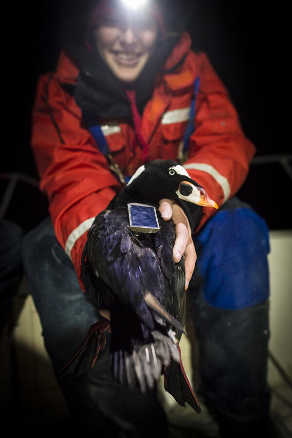
USGS scientist holds a surf scoter that has been tagged.
USGS scientist Sarah Fitzgerald holds a surf scoter that has been fitted with a satellite tag that works by transmitting the location of the birds to satellites that are orbiting the Earth. (Jonathan Fiely, USGS)
USGS scientist Sarah Fitzgerald holds a surf scoter that has been fitted with a satellite tag that works by transmitting the location of the birds to satellites that are orbiting the Earth. (Jonathan Fiely, USGS)