
Image showing NOAA research vessel with logos of NOAA, BOEM, USGS and MBARI. EXPRESS is a multi-year, multi-institution cooperative research campaign in deep sea areas of California, Oregon, and Washington, including the continental shelf and slope.
Images
Images intro.
Filter Total Items: 1196

EXPRESS video cover image
Image showing NOAA research vessel with logos of NOAA, BOEM, USGS and MBARI. EXPRESS is a multi-year, multi-institution cooperative research campaign in deep sea areas of California, Oregon, and Washington, including the continental shelf and slope.

USGS Ocean Research
Our coasts, the most familiar part of the ocean are the gateway to the larger deeper ocean world. USGS studies processes and hazards in the coastal zone and how they affect people, wildlife, and ecosystems.
Our coasts, the most familiar part of the ocean are the gateway to the larger deeper ocean world. USGS studies processes and hazards in the coastal zone and how they affect people, wildlife, and ecosystems.

Examining rocks from the deep ocean
Amy Gartman, USGS Research Oceanographer and chief scientist for the Escanaba Trough expedition, examines a mineral sample with a hand lens aboard R/V Thomas G. Thompson.
Amy Gartman, USGS Research Oceanographer and chief scientist for the Escanaba Trough expedition, examines a mineral sample with a hand lens aboard R/V Thomas G. Thompson.

Examining mineral samples
Tom Lorensen, USGS Physical Scientist, uses an ultraviolet light to examine mineral samples aboard R/V Thomas G. Thompson.
Tom Lorensen, USGS Physical Scientist, uses an ultraviolet light to examine mineral samples aboard R/V Thomas G. Thompson.

Pyrrhotite-rich massive sulfide
Close-up of fine-grained pyrrhotite-rich massive sulfide. The deep-sea sample was collected from the Escanaba Trough, in the Pacific Ocean off the coast of California.
Close-up of fine-grained pyrrhotite-rich massive sulfide. The deep-sea sample was collected from the Escanaba Trough, in the Pacific Ocean off the coast of California.

Hydrothermal chimney composed mostly of barite
Partially weathered hydrothermal chimney, composed mostly of barite (BaSO4). The white material is the outer weathered rind, where the disseminated sulfide minerals have been leached out by oxidation, leaving an orange iron oxide stain.
Partially weathered hydrothermal chimney, composed mostly of barite (BaSO4). The white material is the outer weathered rind, where the disseminated sulfide minerals have been leached out by oxidation, leaving an orange iron oxide stain.

Remotely operated vehicle collects seafloor rock samples
Two hands are better than one! The versatile, ambidextrous ROV (remotely operated vehicle) Jason collects two mineral samples from the seafloor at Escanaba Trough. Jason's sample collection tubes are visible off to the left.
Two hands are better than one! The versatile, ambidextrous ROV (remotely operated vehicle) Jason collects two mineral samples from the seafloor at Escanaba Trough. Jason's sample collection tubes are visible off to the left.

Iron-oxyhydroxide gossan
Iron-oxyhydroxide gossan, formed by weathering of massive sulfide. Dominantly porous orange goethite, with a compact darker to metallic layer of dense goethite.
Iron-oxyhydroxide gossan, formed by weathering of massive sulfide. Dominantly porous orange goethite, with a compact darker to metallic layer of dense goethite.

Fine-grained massive sulfide
Close up of fine-grained massive sulfide containing the primary minerals pyrrhotite, sphalerite, and barite. Weathering has produced secondary minerals, including iron oxide and possibly jarosite. Shiny image shows the same rock under an ultraviolet light source, revealing the minerals that fluoresce under the light.
Close up of fine-grained massive sulfide containing the primary minerals pyrrhotite, sphalerite, and barite. Weathering has produced secondary minerals, including iron oxide and possibly jarosite. Shiny image shows the same rock under an ultraviolet light source, revealing the minerals that fluoresce under the light.

Fine-grained massive sulfide
Close up of fine-grained massive sulfide containing the primary minerals pyrrhotite, sphalerite, and barite. Weathering has produced secondary minerals, including iron oxide and possibly jarosite. Second image shows the same rock under an ultraviolet light source, revealing the minerals that fluoresce under the light.
Close up of fine-grained massive sulfide containing the primary minerals pyrrhotite, sphalerite, and barite. Weathering has produced secondary minerals, including iron oxide and possibly jarosite. Second image shows the same rock under an ultraviolet light source, revealing the minerals that fluoresce under the light.

Fine-grained seafloor massive sulfide
Close up of fine-grained seafloor massive sulfide containing the primary minerals pyrrhotite, sphalerite, and barite. Weathering has produced secondary minerals, including iron oxide and possibly jarosite.
Close up of fine-grained seafloor massive sulfide containing the primary minerals pyrrhotite, sphalerite, and barite. Weathering has produced secondary minerals, including iron oxide and possibly jarosite.

Fine-grained seafloor massive sulfide
Close up of fine-grained seafloor massive sulfide under an ultraviolet light source, revealing the minerals that fluoresce under the light.
Close up of fine-grained seafloor massive sulfide under an ultraviolet light source, revealing the minerals that fluoresce under the light.

ROV collecting a mineral sample
Woods Hole Oceanographic Institute's remotely operated vehicle Jason gathers a mineral sample from the seafloor at Escanaba Trough.
Woods Hole Oceanographic Institute's remotely operated vehicle Jason gathers a mineral sample from the seafloor at Escanaba Trough.

Escanaba Trough location map
Escanaba Trough is the only oceanic spreading center within the U.S. Exclusive Economic Zone. Hundreds of meters of continental sediment have accumulated in the trough, and the combination of sediments and hydrothermal fluids has resulted in a unique hydrothermal system and potentially extensive sulfide mineral precipitation.
Escanaba Trough is the only oceanic spreading center within the U.S. Exclusive Economic Zone. Hundreds of meters of continental sediment have accumulated in the trough, and the combination of sediments and hydrothermal fluids has resulted in a unique hydrothermal system and potentially extensive sulfide mineral precipitation.
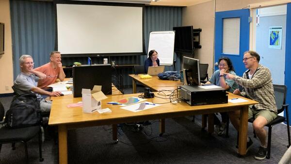
Seafloor Structure-from-Motion (SfM) ad-hoc workshop in St. Petersburg, Florida
The USGS Processes Impacting Seafloor Change and Ecosystem Services (PISCES) project team meeting at the St. Petersburg Coastal and Marine Science Center in May 2022 to coordinate Structure-from-motion (SfM) Quantitative Underwater Imaging Device with 5 cameras (SQUID-5) and diver-based SfM data acquisition and processing for field work.
The USGS Processes Impacting Seafloor Change and Ecosystem Services (PISCES) project team meeting at the St. Petersburg Coastal and Marine Science Center in May 2022 to coordinate Structure-from-motion (SfM) Quantitative Underwater Imaging Device with 5 cameras (SQUID-5) and diver-based SfM data acquisition and processing for field work.

USGS Ocean Research
Our coasts, the most familiar part of the ocean are the gateway to the larger deeper ocean world. USGS studies processes and hazards in the coastal zone and how they affect people, wildlife, and ecosystems.
Our coasts, the most familiar part of the ocean are the gateway to the larger deeper ocean world. USGS studies processes and hazards in the coastal zone and how they affect people, wildlife, and ecosystems.

SQUID-5 test near the St. Pete Pier
The SQUID-5, or Structure-from-motion (SfM) Quantitative Underwater Imaging Device with 5 cameras test in Tampa Bay.
The SQUID-5, or Structure-from-motion (SfM) Quantitative Underwater Imaging Device with 5 cameras test in Tampa Bay.

SQUID-5 deployment in Tampa Bay
The SQUID-5, or Structure-from-motion (SfM) Quantitative Underwater Imaging Device with 5 cameras, being deployed by Mitch Lemon (SPCMSC, on the left) and Gerry Hatcher (PCMSC, on the right) in Tampa Bay for testing.
The SQUID-5, or Structure-from-motion (SfM) Quantitative Underwater Imaging Device with 5 cameras, being deployed by Mitch Lemon (SPCMSC, on the left) and Gerry Hatcher (PCMSC, on the right) in Tampa Bay for testing.

SQUID-5 being prepped for a test run
The SQUID-5, or Structure-from-motion (SfM) Quantitative Underwater Imaging Device with 5 cameras, shown being staged for a test run at the St. Petersburg Coastal and Marine Science Center. In the background, Andy Farmer (SPCMSC) and Gerry Hatcher (PCMSC) prep the R/V Sallenger, the vessel being used to tow the device.
The SQUID-5, or Structure-from-motion (SfM) Quantitative Underwater Imaging Device with 5 cameras, shown being staged for a test run at the St. Petersburg Coastal and Marine Science Center. In the background, Andy Farmer (SPCMSC) and Gerry Hatcher (PCMSC) prep the R/V Sallenger, the vessel being used to tow the device.

Animated gif of ocean waves
Gif of ocean waves. The ocean holds great cultural and economic value and hosts numerous ecosystems that support life on Earth and produce valuable resources. USGS science focuses on improved understanding of many aspects of our world’s interconnected oceanic system, from the continental shelf to the deep sea.
Gif of ocean waves. The ocean holds great cultural and economic value and hosts numerous ecosystems that support life on Earth and produce valuable resources. USGS science focuses on improved understanding of many aspects of our world’s interconnected oceanic system, from the continental shelf to the deep sea.

Idealized animation of tsunamis in the Kingdom of Tonga
Idealized animation of tsunamis produced by the 15 January 2022 eruption of Hunga Tonga-Hunga Ha‛apai volcano in the Kingdom of Tonga. View to the southeast.
Idealized animation of tsunamis produced by the 15 January 2022 eruption of Hunga Tonga-Hunga Ha‛apai volcano in the Kingdom of Tonga. View to the southeast.