
The Weedon Island Preserve is a 3,190-acre coastal system in Tampa Bay, Florida that is comprised of aquatic and upland ecosystems.
Images
Images intro.
Filter Total Items: 672

Panoramic view of Weedon Island, Pinellas County, Florida
The Weedon Island Preserve is a 3,190-acre coastal system in Tampa Bay, Florida that is comprised of aquatic and upland ecosystems.
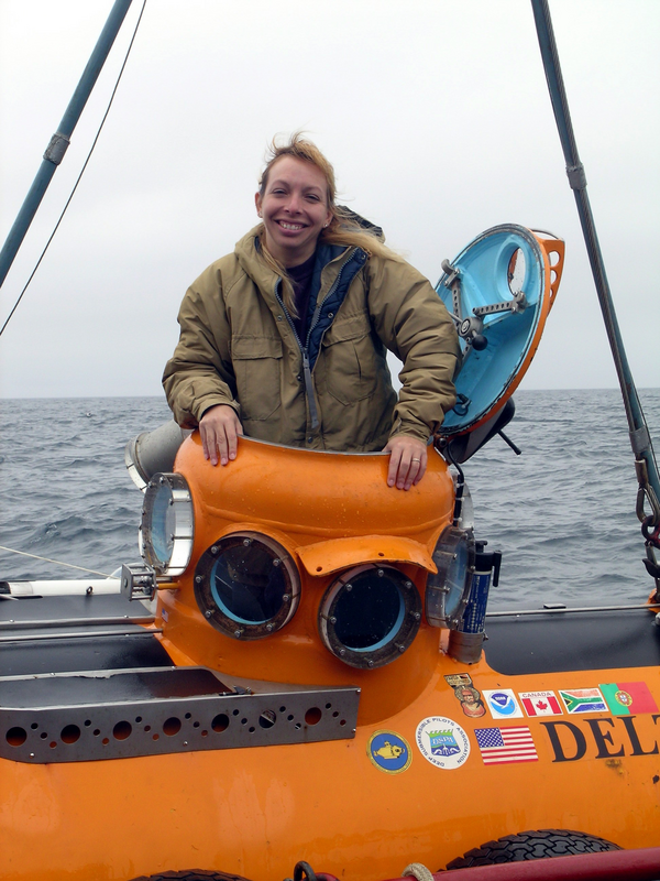
Dr. Christina Kellogg emerges from the submersible Delta
Dr. Christina Kellogg emerges from the submersible Delta after collecting coral samples in the Aleutian Islands in 2004.
Dr. Christina Kellogg emerges from the submersible Delta after collecting coral samples in the Aleutian Islands in 2004.

Aerial photo shows coastal Florida home damage from Hurricane Jeanne
Photograph of the Florida coastline shows storm damage after Hurricane Jeanne's passage.
Photograph of the Florida coastline shows storm damage after Hurricane Jeanne's passage.

Collapsed Five-Story Building at Romar Beach
The lower two floors of the five-story building in the center of these photos have collapsed and the third floor has fallen to ground level.
The lower two floors of the five-story building in the center of these photos have collapsed and the third floor has fallen to ground level.

Coral shading experiment during a bleaching event
Here are shown a series of photographs of a rice coral (Montipora capitata) shaded with light filters during a natural “coral bleaching” event observed during anomalously high ocean temperatures in Autumn of 2004 on the island of Oʻahu, Hawaiʻi.
Here are shown a series of photographs of a rice coral (Montipora capitata) shaded with light filters during a natural “coral bleaching” event observed during anomalously high ocean temperatures in Autumn of 2004 on the island of Oʻahu, Hawaiʻi.

Closeup photograph of home damaged by Hurricane Jeanne in Florida
Zoomed in aerial photograph of a home on the beach near Stuart, Florida, severely damaged by Hurricane Jeanne in September 2004.
Zoomed in aerial photograph of a home on the beach near Stuart, Florida, severely damaged by Hurricane Jeanne in September 2004.
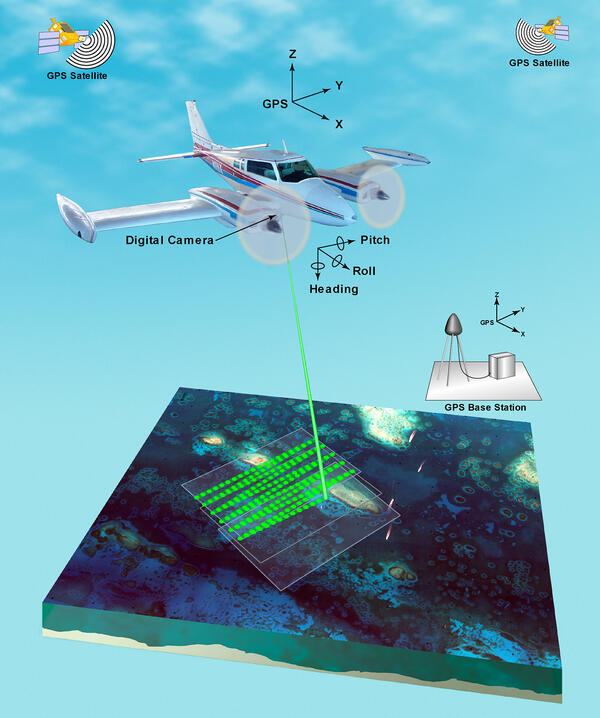
Illustration of airborne lidar acquisition platform
Airborne lidar is a surveying method that measures distance to a target from a survey plane by illuminating that target with a pulsed laser light, and measuring the reflected pulses with a sensor. Differences in laser return times and wavelengths can then be used to make digital 3D-representations of the target.
Airborne lidar is a surveying method that measures distance to a target from a survey plane by illuminating that target with a pulsed laser light, and measuring the reflected pulses with a sensor. Differences in laser return times and wavelengths can then be used to make digital 3D-representations of the target.

Lidar plane
Airborne lidar is a surveying method that measures distance to a target from a survey plane by illuminating that target with a pulsed laser light, and measuring the reflected pulses with a sensor. Differences in laser return times and wavelengths can then be used to make digital 3D-representations of the target.
Airborne lidar is a surveying method that measures distance to a target from a survey plane by illuminating that target with a pulsed laser light, and measuring the reflected pulses with a sensor. Differences in laser return times and wavelengths can then be used to make digital 3D-representations of the target.

BSC Anchorage
Anchored at the mouth of Big Sable Creek in Everglades National Park preparatory to 4-5 days field work on mangrove-associated fish and terrapins.
Anchored at the mouth of Big Sable Creek in Everglades National Park preparatory to 4-5 days field work on mangrove-associated fish and terrapins.

Yellowtop
Yellowtop in bloom along the roadside, just south of the US 27/I-75 (Alligator
Alley) intersection.
Yellowtop in bloom along the roadside, just south of the US 27/I-75 (Alligator
Alley) intersection.

Tamiami Canal
Looking eastward at the Tamiami Canal. Water Conservation Area 3 is to the
left and US 41 (Tamiami Trail) is to the right.
Looking eastward at the Tamiami Canal. Water Conservation Area 3 is to the
left and US 41 (Tamiami Trail) is to the right.

Panoramic of Water Conservation Area 3
Panoramic of Water Conservation Area 3 landscape.
Panoramic of Water Conservation Area 3 landscape.

Panoramic of Biscayne Bay
Facing east, a panoramic view of Biscayne Bay. The mainland is seen at far
right. Biscayne Bay is an estuary, a place where freshwater and salt water
meet. Freshwater flow from the land supplies the bay with nutrients.
Facing east, a panoramic view of Biscayne Bay. The mainland is seen at far
right. Biscayne Bay is an estuary, a place where freshwater and salt water
meet. Freshwater flow from the land supplies the bay with nutrients.

Marine Vegetation and Rocks
Marine vegetation and rocks seen through the surface of Biscayne Bay waters.
Marine vegetation and rocks seen through the surface of Biscayne Bay waters.

Brown Pelican
Adult brown pelican posing on a boat dock at Everglades City, Florida.
Adult brown pelican posing on a boat dock at Everglades City, Florida.

Mangrove Key Islets
Beyond the mangrove key islets that make up the Ten Thousand Islands, lies
the Gulf of Mexico. The Ten Thousand Islands are comprised of hundreds of
mangrove islands that extend northward from the northwest corner of
Everglades National Park. These uninhabited islands stretch for 60-miles
Beyond the mangrove key islets that make up the Ten Thousand Islands, lies
the Gulf of Mexico. The Ten Thousand Islands are comprised of hundreds of
mangrove islands that extend northward from the northwest corner of
Everglades National Park. These uninhabited islands stretch for 60-miles

Lichen
Red patches of "baton-rouge" lichen stand out against the green understory of a
cypress swamp at Loxahatchee National Wildlife Refuge.
Red patches of "baton-rouge" lichen stand out against the green understory of a
cypress swamp at Loxahatchee National Wildlife Refuge.

Cypress swamp
A boardwalk trail through the cypress swamp at Loxahatchee National Wildlife
Refuge.
A boardwalk trail through the cypress swamp at Loxahatchee National Wildlife
Refuge.

Leather fern
The red-tinted fronds of a leather fern, at Loxahatchee National Wildlife Refuge.
The red-tinted fronds of a leather fern, at Loxahatchee National Wildlife Refuge.

Shield fern
Dark green fronds of a shield fern stand out against a mostly royal fern
background, at Loxahatchee National Wildlife Refuge.
Dark green fronds of a shield fern stand out against a mostly royal fern
background, at Loxahatchee National Wildlife Refuge.

Freshwater swamp
Freshwater swamp in front of the Loxahatchee National Wildlife Refuge Visitor
Center.
Freshwater swamp in front of the Loxahatchee National Wildlife Refuge Visitor
Center.