
Photo of researchers looking at mud in the giant box core before beginning to take subcores
Images
Images intro.
Filter Total Items: 672

Photo of researchers looking at mud in the giant box core
Photo of researchers looking at mud in the giant box core before beginning to take subcores

Photo of 6" and 4" subcores sampled from a giant box core
Photograph of 6" and 4" subcores sampled from a giant box core.
Photograph of 6" and 4" subcores sampled from a giant box core.

Photo of planktic foraminifers from the sediment trap
Photograph of planktic foraminifers collected from the sediment trap. Magnified 255x.
Photograph of planktic foraminifers collected from the sediment trap. Magnified 255x.

Expected overwash probabilities at Cape Canaveral from typical storm
This image displays expected overwash probabilities at Cape Canaveral given a typical nor’easter storm striking the coast.
This image displays expected overwash probabilities at Cape Canaveral given a typical nor’easter storm striking the coast.

Collecting terrestrial vibracores on barrier islands
We collect terrestrial (barrier island) and marine (nearshore and estuarine) sediment cores to ground-truth geophysical observations. These cores are used to understand the history of barrier island formation and erosion.
We collect terrestrial (barrier island) and marine (nearshore and estuarine) sediment cores to ground-truth geophysical observations. These cores are used to understand the history of barrier island formation and erosion.

Native community in-ground food storage
The Native communities’ in-ground food storage facilities are being lost as a result of eroding bluffs and thawing permafrost.
The Native communities’ in-ground food storage facilities are being lost as a result of eroding bluffs and thawing permafrost.

Image taken prior to the peak of the Nor'Ida storm event
Though this image was taken prior to the peak of the Nor'Ida storm event, elevated water levels have already eroded the oceanside of a primary dune.
Though this image was taken prior to the peak of the Nor'Ida storm event, elevated water levels have already eroded the oceanside of a primary dune.

View along the railroad tracks on Cape Canaveral
Low dunes on Cape Canaveral often overwash during storm events, transporting sand landward. Critical infrastructure may be buried or flooded. In addition, significant landward transport of sand may lead to extensive shoreline erosion.
Low dunes on Cape Canaveral often overwash during storm events, transporting sand landward. Critical infrastructure may be buried or flooded. In addition, significant landward transport of sand may lead to extensive shoreline erosion.

Photo showing turtle tracks on a dune at Cape Canaveral
Photo showing turtle tracks leading from a nest on a dune at Cape Canaveral.
Photo showing turtle tracks leading from a nest on a dune at Cape Canaveral.

Kristen Hart releasing a satellite-tagged hawksbill sea turtle
Kristen Hart releasing a satellite-tagged hawksbill sea turtle, August 2008, Dry Tortugas National Park.
Kristen Hart releasing a satellite-tagged hawksbill sea turtle, August 2008, Dry Tortugas National Park.

USGS staff collecting vibracore on Ft. DeSoto Beach, Florida
USGS staff collecting a sediment core on Ft. Desoto Beach, Florida using vibracoring equipment. This type of sediment coring uses the vibration of an electric motor to sink an aluminum core barrel into the ground. When the core barrel enters the ground the sediment in the ground fills up the barrel and the crew uses the tripod to pull the core out of the ground.
USGS staff collecting a sediment core on Ft. Desoto Beach, Florida using vibracoring equipment. This type of sediment coring uses the vibration of an electric motor to sink an aluminum core barrel into the ground. When the core barrel enters the ground the sediment in the ground fills up the barrel and the crew uses the tripod to pull the core out of the ground.

Flooding on Texas coast after Hurricane Ike passes
Flooded coastal streets, houses, and fields after Hurricane Ike passes through Texas
Flooded coastal streets, houses, and fields after Hurricane Ike passes through Texas
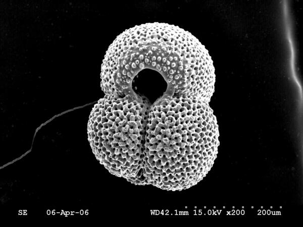
Scanning electron microsope image of the planktic foram Globiger ruber
Scanning electron microsope image of the planktic foraminifer Globigerinoides ruber
Scanning electron microsope image of the planktic foraminifer Globigerinoides ruber

Dauphin Island, Alabama
Dauphin Island, Alabama. Three-dimensional views of island topography (A-C), post-Katrina oblique aerial photograph (D), and differences in topography from Hurricanes Ivan (E) and Katrina (F). The view is along the island, looking from east to west, with the Gulf of Mexico to the left and Mississippi Sound to the right.
Dauphin Island, Alabama. Three-dimensional views of island topography (A-C), post-Katrina oblique aerial photograph (D), and differences in topography from Hurricanes Ivan (E) and Katrina (F). The view is along the island, looking from east to west, with the Gulf of Mexico to the left and Mississippi Sound to the right.

Dauphin Island, Alabama, map views
Dauphin Island, Alabama. Map views of post-storm difference grids for Hurricanes Ivan (A) and Katrina (B), and vertical photography of the same location (C). The lidar images show elevation gains (green) and losses (red).
Dauphin Island, Alabama. Map views of post-storm difference grids for Hurricanes Ivan (A) and Katrina (B), and vertical photography of the same location (C). The lidar images show elevation gains (green) and losses (red).

Before and after photos showing destroyed pier house and classic home
In the top image, taken in 1998, notice the pier, pier house, and the antebellum house. The bottom image shows the same location on August 31, 2005, two days after Hurricane Katrina made landfall. This photo shows the complete destruction of these landmarks.
In the top image, taken in 1998, notice the pier, pier house, and the antebellum house. The bottom image shows the same location on August 31, 2005, two days after Hurricane Katrina made landfall. This photo shows the complete destruction of these landmarks.

Photo sets of Waveland, Mississippi, pre- and post-Katrina
The top image was taken off the coast of Bay St. Louis, Mississippi, in July 1998 by researchers at the University of New Orleans. In this image, notice the large multi-story houses, some of which are built on stilts to protect the homes from flooding. The bottom image shows the same location on August 31, 2005, two days after landfall of Hurricane Katrina.
The top image was taken off the coast of Bay St. Louis, Mississippi, in July 1998 by researchers at the University of New Orleans. In this image, notice the large multi-story houses, some of which are built on stilts to protect the homes from flooding. The bottom image shows the same location on August 31, 2005, two days after landfall of Hurricane Katrina.

Photo sets of Waveland, Mississippi, pre- and post-Katrina
The top image, taken off the coast of Waveland, Mississippi, in July 1998, shows several large oceanfront homes, and thick wooded vegetation bordering the sandy beach. The bottom image shows the same location on August 31, 2005, two days after landfall of Hurricane Katrina.
The top image, taken off the coast of Waveland, Mississippi, in July 1998, shows several large oceanfront homes, and thick wooded vegetation bordering the sandy beach. The bottom image shows the same location on August 31, 2005, two days after landfall of Hurricane Katrina.

Leptogorgia chilensis, Stylaster californicus, and a painted greenling
Leptogorgia chilensis, Stylaster californicus, and a painted greenling (Oxylebius pictus) at 42 meters depth on Farnsworth Bank.
Leptogorgia chilensis, Stylaster californicus, and a painted greenling (Oxylebius pictus) at 42 meters depth on Farnsworth Bank.

Deep-Sea, Cold Water Coral
Coral reef off the Florida Keys.
Coral reef off the Florida Keys.

Coral reef surrounding Loggerhead Key in Dry Tortugas National Park
Looking south over the coral reef surrounding Loggerhead Key, Dry Tortugas National Park. Dry Tortugas Lighthouse stands on Loggerhead Key. To the right in the background is Garden Key, where civil-war era Fort Jefferson is located.
Looking south over the coral reef surrounding Loggerhead Key, Dry Tortugas National Park. Dry Tortugas Lighthouse stands on Loggerhead Key. To the right in the background is Garden Key, where civil-war era Fort Jefferson is located.