
December 20, 2020, Kīlauea volcanic plume shown from the Gemini Observatory on Mauna Kea (left) and a 3D radar visualization from the same perspective. The radar reflectivity isosurfaces reveal the plume’s internal and external structure.
Images
Hawaiian Volcano Observatory images of eruptive activity, field work, and more.
Filter Total Items: 2880

December 20, 2020, Kīlauea volcanic plume
December 20, 2020, Kīlauea volcanic plume shown from the Gemini Observatory on Mauna Kea (left) and a 3D radar visualization from the same perspective. The radar reflectivity isosurfaces reveal the plume’s internal and external structure.

2D and 3D radar visualization of December 20, 2020, Kīlauea plume
Example of 2D and 3D radar visualization of the December 20, 2020, Kīlauea volcanic plume. Displayed in photo (top, USGS photo), 2D radar scan from station PHWA (middle, NOAA Weather and Climate Toolkit), and 3D radar visualization (bottom, Google Earth).
Example of 2D and 3D radar visualization of the December 20, 2020, Kīlauea volcanic plume. Displayed in photo (top, USGS photo), 2D radar scan from station PHWA (middle, NOAA Weather and Climate Toolkit), and 3D radar visualization (bottom, Google Earth).

How measuring gravity on Mauna Kea helps us monitor Mauna Loa
A gravimeter measuring the force of gravity on Mauna Kea. These measurements are used to calibrate the instruments so they can precisely monitor changes in gravity from magma accumulation at Mauna Loa (background). USGS photograph taken on December 10, 2020.
A gravimeter measuring the force of gravity on Mauna Kea. These measurements are used to calibrate the instruments so they can precisely monitor changes in gravity from magma accumulation at Mauna Loa (background). USGS photograph taken on December 10, 2020.

KWcam webcam image from December 2 at 6:00 p.m. HST
KWcam webcam image from December 2 at 6:00 p.m. HST, immediately following a M3.1 earthquake at Kīlauea summit. Several rockfalls down the talus slope impacted the summit water lake, causing some brief localized color changes of the lake surface (circled in yellow).
KWcam webcam image from December 2 at 6:00 p.m. HST, immediately following a M3.1 earthquake at Kīlauea summit. Several rockfalls down the talus slope impacted the summit water lake, causing some brief localized color changes of the lake surface (circled in yellow).

KWcam webcam animated GIF December 2, 2020
ANIMATED GIF: At Kīlauea summit, the KWcam webcam recorded several small color changes along the lake margin following rockfalls which impacted the lake surface. These rockfalls immediately followed a M3.1 earthquake Wednesday evening, December 2, at 5:59 p.m. HST. This animated image file (GIF) continuously loops two consecutive webcam images from 5:50 p.m.
ANIMATED GIF: At Kīlauea summit, the KWcam webcam recorded several small color changes along the lake margin following rockfalls which impacted the lake surface. These rockfalls immediately followed a M3.1 earthquake Wednesday evening, December 2, at 5:59 p.m. HST. This animated image file (GIF) continuously loops two consecutive webcam images from 5:50 p.m.

moon setting over Mauna Loa's broad Northeast Rift Zone
This photo was taken from the west rim of Kīlauea caldera at dawn, and shows the moon setting over Mauna Loa's broad Northeast Rift Zone. USGS photo by M. Patrick.
This photo was taken from the west rim of Kīlauea caldera at dawn, and shows the moon setting over Mauna Loa's broad Northeast Rift Zone. USGS photo by M. Patrick.

Tephra layers preserved at the summit of Kīlauea
Tephra layers preserved at the summit of Kīlauea from at least three different eruptions. Deposits below the top of the scale are predominantly juvenile and deposits above it containing many lithics. Notice the larger size of the yellow pumice clasts compared to the much denser and finer grey lapilli and ash surrounding them from 7 to 18 on the scale.
Tephra layers preserved at the summit of Kīlauea from at least three different eruptions. Deposits below the top of the scale are predominantly juvenile and deposits above it containing many lithics. Notice the larger size of the yellow pumice clasts compared to the much denser and finer grey lapilli and ash surrounding them from 7 to 18 on the scale.

Lake at Kīlauea's summit
Dark brown colors dominated the central and western portions of the lake at Kīlauea's summit. The greenish hues were present in areas that appear to be zone of hot water influx into the lake. USGS photo by M. Patrick.
Dark brown colors dominated the central and western portions of the lake at Kīlauea's summit. The greenish hues were present in areas that appear to be zone of hot water influx into the lake. USGS photo by M. Patrick.

Kīlauea's summit lake between rain showers
A quick visit to the western caldera rim provided brief views of Kīlauea's summit lake between rain showers. The lake colors were particularly vibrant today, with a deep blue-green color in the western end (bottom of photo), with dark brown near the center. USGS photo by M. Patrick.
A quick visit to the western caldera rim provided brief views of Kīlauea's summit lake between rain showers. The lake colors were particularly vibrant today, with a deep blue-green color in the western end (bottom of photo), with dark brown near the center. USGS photo by M. Patrick.

Upper Southwest Rift Zone of Kīlauea Volcano—October 22, 2020
View looking southwest along the Southwest Rift Zone of Kīlauea Volcano. The unvegetated nature of the Southwest Rift Zone is on full display with the Keanakākoʻi Tephra in the foreground overlying lava flows from Cone Peak (the cone in the middle ground to the right).
View looking southwest along the Southwest Rift Zone of Kīlauea Volcano. The unvegetated nature of the Southwest Rift Zone is on full display with the Keanakākoʻi Tephra in the foreground overlying lava flows from Cone Peak (the cone in the middle ground to the right).

Map of Waiʻōhinu area, Island of Hawaiʻi
Map of Waiʻōhinu area, Island of Hawaiʻi, showing the location of the 3,740 year old age.
Map of Waiʻōhinu area, Island of Hawaiʻi, showing the location of the 3,740 year old age.

HVO gas scientists collected helium samples
As part of routine monitoring efforts, HVO gas scientists collected helium samples from fumaroles in the Sulphur Banks, or Ha‘akulamanu, area of Hawai‘i Volcanoes National Park on September 30, 2020. Helium can pass through the glass of typical gas sampling bottles, so copper tubing is necessary for the specialized sample.
As part of routine monitoring efforts, HVO gas scientists collected helium samples from fumaroles in the Sulphur Banks, or Ha‘akulamanu, area of Hawai‘i Volcanoes National Park on September 30, 2020. Helium can pass through the glass of typical gas sampling bottles, so copper tubing is necessary for the specialized sample.

Crystals of pure native sulfur at sites of degassing called fumaroles
Different sulfur gases, including sulfur dioxide (SO2) and hydrogen sulfide (H2S), can react with each other to deposit crystals of pure native sulfur at sites of degassing called fumaroles. The crystals picture here formed within a Sulphur Banks area fumarole in Hawai‘i Volcanoes National Park. USGS photo by T. Elias.
Different sulfur gases, including sulfur dioxide (SO2) and hydrogen sulfide (H2S), can react with each other to deposit crystals of pure native sulfur at sites of degassing called fumaroles. The crystals picture here formed within a Sulphur Banks area fumarole in Hawai‘i Volcanoes National Park. USGS photo by T. Elias.

Close-up image of native sulfur crystals
A close-up image of native sulfur crystals that formed within fumaroles at the Sulphur Banks in Hawai‘i Volcanoes National Park. In addition to sulfur species and other gases, volcanoes emit water vapor. Here, some of the vapor has condensed to liquid water and formed droplets visible on the sulfur crystals. USGS photo by P. Nadeau.
A close-up image of native sulfur crystals that formed within fumaroles at the Sulphur Banks in Hawai‘i Volcanoes National Park. In addition to sulfur species and other gases, volcanoes emit water vapor. Here, some of the vapor has condensed to liquid water and formed droplets visible on the sulfur crystals. USGS photo by P. Nadeau.

Tubing inserted into a fumarole
Tubing inserted into a fumarole at the Sulphur Banks in Hawai‘i Volcanoes National Park allows HVO gas scientists to sample gas. The gas travels through the tube into gas sampling bottles for later analyses. USGS photo by M. Warren.
Tubing inserted into a fumarole at the Sulphur Banks in Hawai‘i Volcanoes National Park allows HVO gas scientists to sample gas. The gas travels through the tube into gas sampling bottles for later analyses. USGS photo by M. Warren.
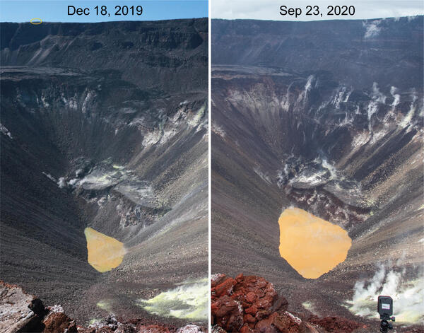
Kīlauea's summit water lake comparison - September 23, 2020
HVO geologists made observations of Kīlauea's summit water lake from the east rim of Halema‘uma‘u. This view point is on the large downdropped block that subsided during the 2018 collapse events. From this spot, a view of the entire lake is possible, providing a new perspective on the growth of the lake.
HVO geologists made observations of Kīlauea's summit water lake from the east rim of Halema‘uma‘u. This view point is on the large downdropped block that subsided during the 2018 collapse events. From this spot, a view of the entire lake is possible, providing a new perspective on the growth of the lake.

Kīlauea's water lake from the east side - September 23, 2020
This view shows Kīlauea's water lake from the east side of the crater. On September 23, 2020, the western portion of the lake (top of image) was the most varied in color, with patches of greenish and brown water. The majority of the lake surface, however, was the typical tan hue. USGS photo by M. Patrick.
This view shows Kīlauea's water lake from the east side of the crater. On September 23, 2020, the western portion of the lake (top of image) was the most varied in color, with patches of greenish and brown water. The majority of the lake surface, however, was the typical tan hue. USGS photo by M. Patrick.

Floating material on Kīlauea's summit water lake on September 23, 2020
Small patches of light-colored floating material were seen drifting on the surface of Kīlauea's summit water lake on September 23, 2020. The composition of this material is unknown, but future water sampling missions may provide insight. USGS photo by M. Patrick.
Small patches of light-colored floating material were seen drifting on the surface of Kīlauea's summit water lake on September 23, 2020. The composition of this material is unknown, but future water sampling missions may provide insight. USGS photo by M. Patrick.

Kīlauea’s summit water lake and Crater Rim Drive - September 23, 2020
Portions of Crater Rim Drive, within Hawai‘i Volcanoes National Park, appear cracked, offset, and down-dropped in this photo, taken during an overflight of Kīlauea’s summit on September 23, 2020. To the north, Kīlauea’s summit water lake, within Halema‘uma‘u, is visible. USGS photo by K. Mulliken.
Portions of Crater Rim Drive, within Hawai‘i Volcanoes National Park, appear cracked, offset, and down-dropped in this photo, taken during an overflight of Kīlauea’s summit on September 23, 2020. To the north, Kīlauea’s summit water lake, within Halema‘uma‘u, is visible. USGS photo by K. Mulliken.

Sulphur Banks area and Ha‘akulamanu trail
Hawaiian Volcano Observatory geologists flew over the Sulphur Banks area and Ha‘akulamanu trail within Hawai‘i Volcanoes National Park on September 23, 2020. Fumaroles in the Sulphur Banks area are sampled approximately every three months by Hawaiian Volcano Observatory gas geochemists to track long-term changes in volcanic gas chemistry at Kīlauea.
Hawaiian Volcano Observatory geologists flew over the Sulphur Banks area and Ha‘akulamanu trail within Hawai‘i Volcanoes National Park on September 23, 2020. Fumaroles in the Sulphur Banks area are sampled approximately every three months by Hawaiian Volcano Observatory gas geochemists to track long-term changes in volcanic gas chemistry at Kīlauea.

Wahinekapu (Steaming Bluff) and the Steam Vents area
The weather was overcast during an overflight of Kīlauea's summit on September 23, 2020. This view shows Wahinekapu (Steaming Bluff) and the Steam Vents area within Hawai‘i Volcanoes National Park. Extensive cracks in the area allow heated groundwater to escape from underground.
The weather was overcast during an overflight of Kīlauea's summit on September 23, 2020. This view shows Wahinekapu (Steaming Bluff) and the Steam Vents area within Hawai‘i Volcanoes National Park. Extensive cracks in the area allow heated groundwater to escape from underground.