
About 1300 earthquakes with magnitudes greater than 1 and at depths over 20 km (12 mi) on and around the Island of Hawai‘i since August 2019 are depicted on this map. Most of the earthquakes were clustered beneath the southern edge of the island near the town of Pāhala.
Images
Hawaiian Volcano Observatory images of eruptive activity, field work, and more.
Filter Total Items: 2896

Island of Hawai‘i earthquakes since August 2019
About 1300 earthquakes with magnitudes greater than 1 and at depths over 20 km (12 mi) on and around the Island of Hawai‘i since August 2019 are depicted on this map. Most of the earthquakes were clustered beneath the southern edge of the island near the town of Pāhala.

Geologic map of the central-southeast flank of Mauna Loa
The recently published "Geologic map of the central-southeast flank of Mauna Loa" (https://pubs.er.usgs.gov/publication/sim2932B), shown here, uses color to depict ages of geologic units, with warm colors denoting younger units and cool colors indicating older units.
The recently published "Geologic map of the central-southeast flank of Mauna Loa" (https://pubs.er.usgs.gov/publication/sim2932B), shown here, uses color to depict ages of geologic units, with warm colors denoting younger units and cool colors indicating older units.

Jo Schmith examining ash from Katla volcano in Iceland
Jo Schmith examining ash from Katla volcano in Iceland.
Jo Schmith examining ash from Katla volcano in Iceland.

December 18, 2019 thermal image of Kīlauea summit
The December 18 overflight provided updated thermal images of Kīlauea summit, covering the caldera floor and showing the warm surface of the water pond in Halema‘uma‘u crater. A band of warm temperatures persists along the new cliff formed during the 2018 subsidence.
The December 18 overflight provided updated thermal images of Kīlauea summit, covering the caldera floor and showing the warm surface of the water pond in Halema‘uma‘u crater. A band of warm temperatures persists along the new cliff formed during the 2018 subsidence.

December 18, 2019 aerial map of Kīlauea summit
The December 18, 2019, overflight provided updated aerial photographs of Kīlauea summit, covering the caldera floor and showing the current size of the water pond in Halema‘uma‘u crater.
The December 18, 2019, overflight provided updated aerial photographs of Kīlauea summit, covering the caldera floor and showing the current size of the water pond in Halema‘uma‘u crater.

Halema‘uma‘u water lake at the summit of Kīlauea Volcano
The growing lake of groundwater within Halema‘uma‘u at the summit of Kīlauea Volcano as it looked on December 18, 2019.
The growing lake of groundwater within Halema‘uma‘u at the summit of Kīlauea Volcano as it looked on December 18, 2019.

Volcano Awareness Month 2020
Volcano Awareness Month programs offered in January 2020 are depicted by these images. Clockwise from top left: ground cracks opened at HVO's former location atop Kīlauea in 2018; fissure erupting on Mauna Loa in March 1984; crater lake within Halema‘uma‘u at Kīlauea's summit; and visitors hiking a Kahuku trail in Hawai‘i Volcanoes National Park (NPS).
Volcano Awareness Month programs offered in January 2020 are depicted by these images. Clockwise from top left: ground cracks opened at HVO's former location atop Kīlauea in 2018; fissure erupting on Mauna Loa in March 1984; crater lake within Halema‘uma‘u at Kīlauea's summit; and visitors hiking a Kahuku trail in Hawai‘i Volcanoes National Park (NPS).

USGS HVO geophysicist Jefferson Chang presenting
USGS Hawaiian Volcano Observatory geophysicist Jefferson Chang during his presentation at the 2019 National Diversity in STEM Conference in Honolulu. Chang and Kevan Kamibayashi (left) were two of four HVO scientists who spoke about their work monitoring Hawaiian volcanoes at the SACNAS conference.
USGS Hawaiian Volcano Observatory geophysicist Jefferson Chang during his presentation at the 2019 National Diversity in STEM Conference in Honolulu. Chang and Kevan Kamibayashi (left) were two of four HVO scientists who spoke about their work monitoring Hawaiian volcanoes at the SACNAS conference.

Jefferson Chang at meeting
Jefferson Chang (far left) was one of four USGS Hawaiian Volcano Observatory scientists who spoke about monitoring Hawaiian volcanoes and mentored students at the 2019 National Diversity in STEM Conference in Honolulu.
Jefferson Chang (far left) was one of four USGS Hawaiian Volcano Observatory scientists who spoke about monitoring Hawaiian volcanoes and mentored students at the 2019 National Diversity in STEM Conference in Honolulu.

PAINTING
The 1880-1881 eruption of Mauna Loa produced lava flows that came within 1.7 km (1.1 mi) of the Hilo Bay shoreline. This painting by Charles Furneaux, "Night View 1880–1881, Eruption from Hilo Bay," illustrates the first two flows as they would have been in November 1880. In reality, however, both flows would not have been visible from this vantage.
The 1880-1881 eruption of Mauna Loa produced lava flows that came within 1.7 km (1.1 mi) of the Hilo Bay shoreline. This painting by Charles Furneaux, "Night View 1880–1881, Eruption from Hilo Bay," illustrates the first two flows as they would have been in November 1880. In reality, however, both flows would not have been visible from this vantage.

Continued slow rise of water level at bottom of Halema‘uma‘u, November
Photos taken two weeks apart show the rise of water in Halema‘uma‘u. A white arrow denotes a large rock along the edge of the lake for comparing water levels in the two images. The water continues to rise at a rate of approximately 15 cm (6 in) per day. USGS photos by M. Patrick.
Photos taken two weeks apart show the rise of water in Halema‘uma‘u. A white arrow denotes a large rock along the edge of the lake for comparing water levels in the two images. The water continues to rise at a rate of approximately 15 cm (6 in) per day. USGS photos by M. Patrick.

Short-term Sulfur Dioxide Advisory Level Information table
The "Short-term Sulfur Dioxide Advisory Level Information" table (http://www.hiso2index.info/assets/FinalSO2Exposurelevels.pdf) uses a six-tiered color-coded system to depict sulfur dioxide (SO2) concentrations and provide guidance for different groups of people exposed to SO2
The "Short-term Sulfur Dioxide Advisory Level Information" table (http://www.hiso2index.info/assets/FinalSO2Exposurelevels.pdf) uses a six-tiered color-coded system to depict sulfur dioxide (SO2) concentrations and provide guidance for different groups of people exposed to SO2

Water collected from the lake at the bottom of Halema‘uma‘u
Water collected from the lake at the bottom of Halema‘uma‘u is prepared for laboratory analyses at the USGS California Volcano Observatory. Results thus far reveal chemistry indicative of complex reactions among the water, magmatic gases and Kīlauea's basaltic rocks.
Water collected from the lake at the bottom of Halema‘uma‘u is prepared for laboratory analyses at the USGS California Volcano Observatory. Results thus far reveal chemistry indicative of complex reactions among the water, magmatic gases and Kīlauea's basaltic rocks.

Water collected from the lake at the bottom of Halema‘uma‘u
Water collected from the lake at the bottom of Halema‘uma‘u is prepared for laboratory analyses at the USGS California Volcano Observatory. Results thus far reveal chemistry indicative of complex reactions between the water, magmatic gases, and Kīlauea's basaltic rocks.
Water collected from the lake at the bottom of Halema‘uma‘u is prepared for laboratory analyses at the USGS California Volcano Observatory. Results thus far reveal chemistry indicative of complex reactions between the water, magmatic gases, and Kīlauea's basaltic rocks.

Unoccupied Aircraft System is inspected by pilot just before take off
The sampling mechanism (on blue tarp) is prepared and the Unoccupied Aircraft System (UAS) is inspected just before take off to collect water from the Halema‘uma‘u crater lake. Brightly colored flagging tape tied to a cable attached to the UAS indicated depth as the sampling tool was lowered into the water.
The sampling mechanism (on blue tarp) is prepared and the Unoccupied Aircraft System (UAS) is inspected just before take off to collect water from the Halema‘uma‘u crater lake. Brightly colored flagging tape tied to a cable attached to the UAS indicated depth as the sampling tool was lowered into the water.

Unoccupied Aircraft System returning with a water sample.
USGS-HVO scientists and DOI UAS team members collect samples of water from the Halema‘uma‘u crater lake.
USGS-HVO scientists and DOI UAS team members collect samples of water from the Halema‘uma‘u crater lake.

HVO scientists prepare UAS for Kīlauea summit crater lake sampling
USGS Hawaiian Volcano Observatory and DOI Office of Aviation staff prepare the sampling mechanism (on blue tarp) and inspect the Unmanned Aircraft System (UAS) just before it took off to collect water from the Halema‘uma‘u crater lake.
USGS Hawaiian Volcano Observatory and DOI Office of Aviation staff prepare the sampling mechanism (on blue tarp) and inspect the Unmanned Aircraft System (UAS) just before it took off to collect water from the Halema‘uma‘u crater lake.

Mauna Loa sulphur cone
Sulphur Cone (left), viewed toward southwest, from 3,480 m (11,420 ft) above sea level on Mauna Loa’s southwest rift zone. At right, an HVO geoscientist and technician rebuild volcanic gas monitoring equipment installed near an outgassing fissure.
Sulphur Cone (left), viewed toward southwest, from 3,480 m (11,420 ft) above sea level on Mauna Loa’s southwest rift zone. At right, an HVO geoscientist and technician rebuild volcanic gas monitoring equipment installed near an outgassing fissure.

Geophysicist Sarah Conway, USGS HVO geophysicist
Geophysicist Sarah Conway, a member of the USGS Hawaiian Volcano Observatory's deformation team, readies a temporary GPS station during a campaign survey of benchmarks on Kīlauea Volcano to monitor changes in the ground surface.
Geophysicist Sarah Conway, a member of the USGS Hawaiian Volcano Observatory's deformation team, readies a temporary GPS station during a campaign survey of benchmarks on Kīlauea Volcano to monitor changes in the ground surface.

Mountain Ararat
Glacier caps Greater Ararat, looking 30 km (19 miles) north through hotel window in Dogubeyazit, Turkey, September 16, 2019. Photo by Don Swanson.
Glacier caps Greater Ararat, looking 30 km (19 miles) north through hotel window in Dogubeyazit, Turkey, September 16, 2019. Photo by Don Swanson.
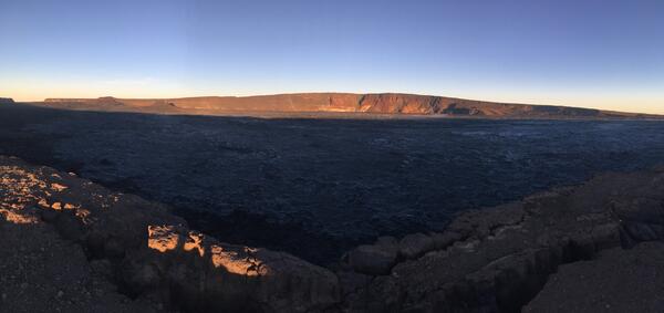
early morning view looking north across Moku‘āweoweo
An early morning view looking north across Moku‘āweoweo, Mauna Loa's summit caldera, from a spot near the summit cabin on the volcano's south caldera rim. Frost covered much of the caldera floor that was still shadowed, and weak steaming issued from the usual areas. Overall, there were no significant changes observed at the summit.
An early morning view looking north across Moku‘āweoweo, Mauna Loa's summit caldera, from a spot near the summit cabin on the volcano's south caldera rim. Frost covered much of the caldera floor that was still shadowed, and weak steaming issued from the usual areas. Overall, there were no significant changes observed at the summit.