Debris leftover from the 12 May 2008 earthquake lines the sidewalks in Dujiangyan.
All Multimedia
Access all multimedia to include images, video, audio, webcams, before-after imagery, and more. Filter and explore with filtering options to refine search.
Debris leftover from the 12 May 2008 earthquake lines the sidewalks in Dujiangyan.
The 12 May 2008 earthquake was strong enough to destroy these buildings in Dujiangyan.
The 12 May 2008 earthquake was strong enough to destroy these buildings in Dujiangyan.
Buildings as damaged as this one, in Guyuan, were roped off after the 12 May 2008 earthquake.
Buildings as damaged as this one, in Guyuan, were roped off after the 12 May 2008 earthquake.
Some buildings, such as this one in Guyuan, were extensively damaged by the 12 May 2008 earthquake.
Some buildings, such as this one in Guyuan, were extensively damaged by the 12 May 2008 earthquake.
After the 12 May 2008 earthquake, some people in Guyuan were forced to stay in tents because of damage to their homes.
After the 12 May 2008 earthquake, some people in Guyuan were forced to stay in tents because of damage to their homes.
Small tent cities, like this one in Guyuan, were erected after the 12 May 2008 earthquake.
Small tent cities, like this one in Guyuan, were erected after the 12 May 2008 earthquake.
These tent structures served as temporary homes in Guyuan after the 12 May 2008 earthquake.
These tent structures served as temporary homes in Guyuan after the 12 May 2008 earthquake.
In Guyuan, an outdoor bathroom was created for those who stayed in tents because their homes were too dangerous.
In Guyuan, an outdoor bathroom was created for those who stayed in tents because their homes were too dangerous.
Some families in Guyuan had to fashion tents out of whatever materials were on hand to avoid staying in their damaged homes after the 12 May 2008 earthquake.
Some families in Guyuan had to fashion tents out of whatever materials were on hand to avoid staying in their damaged homes after the 12 May 2008 earthquake.
Litter and debris line the nearly empty streets of Guyuan after the 12 May 2008 earthquake.
Litter and debris line the nearly empty streets of Guyuan after the 12 May 2008 earthquake.
Emergency tents are a common sight on the road from Dujiangyan to Guyuan after the 12 May 2008 earthquake.
Emergency tents are a common sight on the road from Dujiangyan to Guyuan after the 12 May 2008 earthquake.
This home, on the road from Dujiangyan to Guyuan, was damaged in the 12 May 2008 earthquake.
This home, on the road from Dujiangyan to Guyuan, was damaged in the 12 May 2008 earthquake.
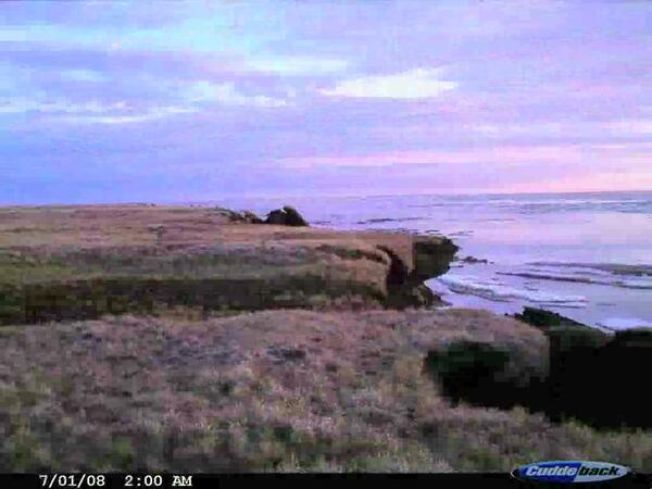
 Drew Point, AK Time-Lapse Photography of Coastal Erosion
4-week time-lapse photography of the Arctic coast at Drew Point, AK shows intense coastal erosion in early July, 2008
4-week time-lapse photography of the Arctic coast at Drew Point, AK shows intense coastal erosion in early July, 2008
Listen to hear the answer.

Volcanic-gas plume rises from Halema‘uma‘u Crater, Kīlauea Volcano, Hawai‘i
Volcanic-gas plume rises from Halema‘uma‘u Crater, Kīlauea Volcano, Hawai‘i
Listen to hear the answer.

Scientists collecting samples of runoff from a test plot during a simulated rainfall event. The field received an application of biosolids, and the runoff samples were analyzed for organic chemicals that are commonly used in our everyday lives.
Scientists collecting samples of runoff from a test plot during a simulated rainfall event. The field received an application of biosolids, and the runoff samples were analyzed for organic chemicals that are commonly used in our everyday lives.
Listen to hear the answer.
Want to stay on top of wildlife disease developments throughout the world? USGS scientists Josh Dein and Hon Ip, and USGS web content manager Cris Marsh tell us how with some great Web tracking tools.
Want to stay on top of wildlife disease developments throughout the world? USGS scientists Josh Dein and Hon Ip, and USGS web content manager Cris Marsh tell us how with some great Web tracking tools.
The narrow waters of Drake's Passage separate the U.S. Virgin Islands (foreground) from the British Virgin Islands in the distance.
The narrow waters of Drake's Passage separate the U.S. Virgin Islands (foreground) from the British Virgin Islands in the distance.
The narrow waters of Drake's Passage separate the U.S. Virgin Islands (foreground) from the British Virgin Islands in the distance.
The narrow waters of Drake's Passage separate the U.S. Virgin Islands (foreground) from the British Virgin Islands in the distance.


