
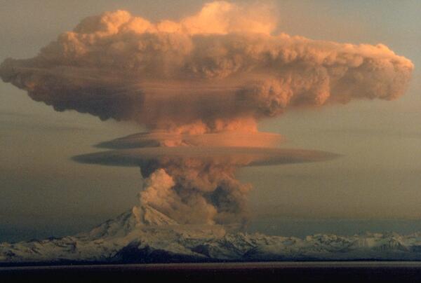
Ascending eruption cloud from Redoubt Volcano as viewed to the west from the Kenai Peninsula. The mushroom-shaped plume rose from avalanches of hot debris (pyroclastic flows) that cascaded down the north flank of the volcano. A smaller, white steam plume rises from the summit crater.
All Multimedia
Access all multimedia to include images, video, audio, webcams, before-after imagery, and more. Filter and explore with filtering options to refine search.
Filter Total Items: 26025
Redoubt Volcano
Ascending eruption cloud from Redoubt Volcano as viewed to the west from the Kenai Peninsula. The mushroom-shaped plume rose from avalanches of hot debris (pyroclastic flows) that cascaded down the north flank of the volcano. A smaller, white steam plume rises from the summit crater.

Lava flow encroaching on Kalapana Gardens subdivision, Kīlauea
Aerial view of pāhoehoe flow encroaching on the Kalapana community. Hakuma horst, a raised fault block, is on the left. To the right of the point are fishponds, and to their right, Walter's Kalapana Store and Drive Inn. In the large trapezoidal plot are Mauna Kea Congregational Church and hall.
Aerial view of pāhoehoe flow encroaching on the Kalapana community. Hakuma horst, a raised fault block, is on the left. To the right of the point are fishponds, and to their right, Walter's Kalapana Store and Drive Inn. In the large trapezoidal plot are Mauna Kea Congregational Church and hall.

Stringing Nets to Catch Mongooses
For a behavioral study of Crossarchus obscurus, the long-nosed cusimanse, in Tiwai Island Wildlife Sanctuary, Sierra Leone, West Africa, fishing nets were the most successful method of capturing an entire group of these mongooses, compared to baited live-traps and thatch fences (which channeled animals into live traps, and which were moderately successful).
For a behavioral study of Crossarchus obscurus, the long-nosed cusimanse, in Tiwai Island Wildlife Sanctuary, Sierra Leone, West Africa, fishing nets were the most successful method of capturing an entire group of these mongooses, compared to baited live-traps and thatch fences (which channeled animals into live traps, and which were moderately successful).

John Wesley Powell
Typed information on back of photograph: Major John W. Powell. BAE Neg. No. 64-b-1 (R). Photograph date, 1898.
Handwritten notes on back of photograph: Photograph by Parker, Washington, D.C. BAE Neg. No. 64-b-2 has photographer's name and Powell's signature.
Typed information on back of photograph: Major John W. Powell. BAE Neg. No. 64-b-1 (R). Photograph date, 1898.
Handwritten notes on back of photograph: Photograph by Parker, Washington, D.C. BAE Neg. No. 64-b-2 has photographer's name and Powell's signature.

Loma Prieta earthquake, Marina District
An automobile lies crushed under the third story of this apartment building in the Marina District. The ground levels are no longer visible because of structural failure and sinking due to liquefaction.
An automobile lies crushed under the third story of this apartment building in the Marina District. The ground levels are no longer visible because of structural failure and sinking due to liquefaction.

Porkchop Geyser erupting in August 1989
Porkchop Geyser erupting in August 1989.
Porkchop Geyser erupting in August 1989.

Angle and distance measurements to Mount St. Helens' flanks were ta...
Angle and distance measurements to the Mount St. Helens' flanks were taken periodically to monitor for deformation similar to the 1980 bulge. Station northeast of volcano.
Angle and distance measurements to the Mount St. Helens' flanks were taken periodically to monitor for deformation similar to the 1980 bulge. Station northeast of volcano.

Five Millionth Scene
The Landsat Global Archive Consolidation initiative has retrieved and ingested its 5 millionth image since it began in 2010. The data came from the Riyadh Ground Station in Saudi Arabia and was acquired by Landsat 5 on April 16, 1989. It shows an area over Bahrain, Qatar, and Saudi Arabia.
The Landsat Global Archive Consolidation initiative has retrieved and ingested its 5 millionth image since it began in 2010. The data came from the Riyadh Ground Station in Saudi Arabia and was acquired by Landsat 5 on April 16, 1989. It shows an area over Bahrain, Qatar, and Saudi Arabia.

Cliff Palace, Mesa Verde National Park, Colorado - 1989
The kivas, which were unexcavated by Nordenskiöld, are now exposed. Fewkes did considerable repair of the tower, kivas, and other structures when he excavated the ruin in 1909. Paths for visitors have been added to facilitate access. (Bill Howard).
The kivas, which were unexcavated by Nordenskiöld, are now exposed. Fewkes did considerable repair of the tower, kivas, and other structures when he excavated the ruin in 1909. Paths for visitors have been added to facilitate access. (Bill Howard).

Ice cone at Porkchop Geyser in March 1989
Ice cone at Porkchop Geyser in March 1989.
Ice cone at Porkchop Geyser in March 1989.

Giant Hawaiian Underwater Landslides
Large-scale poster describing USGS work.
The USGS, in cooperation with the UK Institute of Oceanographic Sciences (IOS) and others, took images of the seafloor 200 miles around the Hawaiian Islands using GLORIA. GLORIA is a long-range sonar that gives a bird’s-eye view of the seafloor.
Large-scale poster describing USGS work.
The USGS, in cooperation with the UK Institute of Oceanographic Sciences (IOS) and others, took images of the seafloor 200 miles around the Hawaiian Islands using GLORIA. GLORIA is a long-range sonar that gives a bird’s-eye view of the seafloor.

Lava bubble burst explosion, Kīlauea, Hawai‘i
A thin-walled lava bubble expands and bursts. These "bubble bursts" occur when seawater infiltrates the lava tube system near the shore. Such bubble bursts produce translucent sheets of spatter, or limu o Pele.
A thin-walled lava bubble expands and bursts. These "bubble bursts" occur when seawater infiltrates the lava tube system near the shore. Such bubble bursts produce translucent sheets of spatter, or limu o Pele.
Glacial end moraine deposits on south flank of Mauna Kea, Hawai‘i
Glacial end moraine deposits on south flank of Mauna Kea, Hawai‘i
Glacial end moraine deposits on south flank of Mauna Kea, Hawai‘i

Northeast flank Mauna Kea, Hawai‘i from about 5,200 ft to summit. P...
The light colored lava flows in foreground are part of the older Laupahoehoe Volcanics, erupted between 70,000 to 13,000 years ago. one of the youngest cinder cones erupted by the volcano,
The light colored lava flows in foreground are part of the older Laupahoehoe Volcanics, erupted between 70,000 to 13,000 years ago. one of the youngest cinder cones erupted by the volcano,

Pu‘umaKAHAKOkanaka, NE flank of Mauna Kea, Hawai‘i
12,398 ft elev according to USGS Geographic Names Information System
12,398 ft elev according to USGS Geographic Names Information System

Upper south flank of Mauna Kea, Hawai‘i. Prominent cinder cone (low...
Pu‘u Keonehehe‘e and the two small cones immediately to the northwest (left) are among the youngest cones erupted on the volcano, as recent as about 4,000 years ago. The other cones in this view are part of the Laupahoehoe Volcanics, but much older, dating to 70,000 years ago.
Pu‘u Keonehehe‘e and the two small cones immediately to the northwest (left) are among the youngest cones erupted on the volcano, as recent as about 4,000 years ago. The other cones in this view are part of the Laupahoehoe Volcanics, but much older, dating to 70,000 years ago.

Deformation measurements on the Mount St. Helens' dome; three geolo...
Deformation measurements on the Mount St. Helens' dome; three geologists in middle bottom of this aerial photograph.
Deformation measurements on the Mount St. Helens' dome; three geologists in middle bottom of this aerial photograph.

China's Qaidam Basin Landscape Similar with Mars
Geologist, sedimentation expert and Mars Science Laboratory team member David Rubin of the USGS Pacific Coastal and Marine Science Center investigates longitudinal dunes in China's Qaidam Basin. He comments: "The landscape has some similarity with Mars: almost total lack of vegetation and wind-formed landscape."
Geologist, sedimentation expert and Mars Science Laboratory team member David Rubin of the USGS Pacific Coastal and Marine Science Center investigates longitudinal dunes in China's Qaidam Basin. He comments: "The landscape has some similarity with Mars: almost total lack of vegetation and wind-formed landscape."

Tephra jet explosion, Kīlauea, Hawai‘i
Explosive interaction between lava and seawater blasts a tephra jet consisting of steam, hot water, black tephra, and molten fragments into the air. This explosion is directed primarily toward the sea, but many explosions also send a shower of lava more than 10 to 20 m inland.
Explosive interaction between lava and seawater blasts a tephra jet consisting of steam, hot water, black tephra, and molten fragments into the air. This explosion is directed primarily toward the sea, but many explosions also send a shower of lava more than 10 to 20 m inland.

1987 GIS Spatial Analysis Tools Short
A 1987 video from the USGS Earth Resources Observation and Science (EROS) Center on geospatial analysis tools - short version
A 1987 video from the USGS Earth Resources Observation and Science (EROS) Center on geospatial analysis tools - short version

Mount Adams southern view as seen from Trout Lake, WA. Trout Lake s...
Mount Adams southern view as seen from Trout Lake, Washington. Trout Lake sits on thick lahar deposits that originated as a debris avalanche 6,000 years ago.
Mount Adams southern view as seen from Trout Lake, Washington. Trout Lake sits on thick lahar deposits that originated as a debris avalanche 6,000 years ago.