
Crustal foundering—less-dense liquid lava overriding and sinking thin surface crust—is common in the lava lake within Halema‘uma‘u, at the summit of Kīlauea. Here, large sections of the crust are foundering, resurfacing the lake. USGS photo by M. Patrick on March 22, 2021.
Images
Explore our planet through photography and imagery, including climate change and water all the way back to the 1800s when the USGS was surveying the country by horse and buggy.
Filter Total Items: 21557

Halema‘uma‘u lava lake, Kīlauea summit eruption—March 22, 2021
Crustal foundering—less-dense liquid lava overriding and sinking thin surface crust—is common in the lava lake within Halema‘uma‘u, at the summit of Kīlauea. Here, large sections of the crust are foundering, resurfacing the lake. USGS photo by M. Patrick on March 22, 2021.

Halema‘uma‘u lava lake, Kīlauea summit eruption—March 22, 2021
This photo shows one of the islands near the inlet in the lava lake in Halema‘uma‘u, at the summit of Kīlauea. Over the past two weeks, the island has tilted 90 degrees, producing the vertical layering visible here. USGS photo by M. Patrick on March 22, 2021.
This photo shows one of the islands near the inlet in the lava lake in Halema‘uma‘u, at the summit of Kīlauea. Over the past two weeks, the island has tilted 90 degrees, producing the vertical layering visible here. USGS photo by M. Patrick on March 22, 2021.

Halema‘uma‘u lava lake, Kīlauea summit eruption—March 22, 2021
This photo shows the levee that bounds the southern margin of the active lake in Halema‘uma‘u. The levee is formed, in part, by numerous small crustal plates pushed over the rim. USGS photo by M. Patrick on March 22, 2021.
This photo shows the levee that bounds the southern margin of the active lake in Halema‘uma‘u. The levee is formed, in part, by numerous small crustal plates pushed over the rim. USGS photo by M. Patrick on March 22, 2021.

Halema‘uma‘u lava lake, Kīlauea summit eruption—March 22, 2021
This photo shows the northern portion of the active lava lake in Halema‘uma‘u, at the summit of Kīlauea. Like the southern portion of the lake, this northern zone is also contained by steep, well-defined levees. USGS photo by M. Patrick on March 22, 2021.
This photo shows the northern portion of the active lava lake in Halema‘uma‘u, at the summit of Kīlauea. Like the southern portion of the lake, this northern zone is also contained by steep, well-defined levees. USGS photo by M. Patrick on March 22, 2021.

Repeat photo of Grinnell Glacier (1910, 2007)
Boulder Glacier in 1910 (Elrod photo, GNP Archives) and in 2007 (Fagre/Pederson photo, USGS). Matching the intersection of the peaks in the background helps the repeat photographer locate the photo point. USGS Public domain
Boulder Glacier in 1910 (Elrod photo, GNP Archives) and in 2007 (Fagre/Pederson photo, USGS). Matching the intersection of the peaks in the background helps the repeat photographer locate the photo point. USGS Public domain

Photograph & photomicrographs from exotic duck with avian tuberculosis
Photographs and photomicrographs from an exotic duck. (A) Grossly, the spleen is enlarged, firm, and yellow (arrow). Throughout the liver are multifocal to coalescing firm tan nodules (arrowheads). (B) The liver contains multifocal granulomas (asterisk). H&E stain.
Photographs and photomicrographs from an exotic duck. (A) Grossly, the spleen is enlarged, firm, and yellow (arrow). Throughout the liver are multifocal to coalescing firm tan nodules (arrowheads). (B) The liver contains multifocal granulomas (asterisk). H&E stain.

GLSC Diver Collects Cladophora Samples in Lake Michigan
Emily Wimmer (GLSC, Ann Arbor, Michigan) collects Cladophora growing at 6m depth in Lake Michigan.
Emily Wimmer (GLSC, Ann Arbor, Michigan) collects Cladophora growing at 6m depth in Lake Michigan.

Kintla Glacier in 1901 and 2019
Grinnell, Gem & Salamander Glaciers: 8/9/1910 M Elrod, U of M Library – 9/27/2016 L McKeon, USGS
View the full collection at USGS Photographic Library
Grinnell, Gem & Salamander Glaciers: 8/9/1910 M Elrod, U of M Library – 9/27/2016 L McKeon, USGS
View the full collection at USGS Photographic Library

Halema‘uma‘u Eruption Activity on 18 March 2021
On Thursday, March 18, lava continued to erupt from the west vent in Halema‘uma‘u crater at Kīlauea Volcano's summit. Two lava inlets near the base of the west vent (center) supply lava into the lava lake. This photo was taken around 7:15 a.m.
On Thursday, March 18, lava continued to erupt from the west vent in Halema‘uma‘u crater at Kīlauea Volcano's summit. Two lava inlets near the base of the west vent (center) supply lava into the lava lake. This photo was taken around 7:15 a.m.

March 18, 2021—West vent in Halema‘uma‘u crater at Kīlauea summit
On March 18, 2021, morning light illuminated the west vent in Halema‘uma‘u crater at Kīlauea Volcano's summit. Small collapses of the cone have accumulated into a loose pile of rubble (left) on the stagnant crust at its base—adjacent to the active lava lake (lower-right). USGS photo by K. Lynn.
On March 18, 2021, morning light illuminated the west vent in Halema‘uma‘u crater at Kīlauea Volcano's summit. Small collapses of the cone have accumulated into a loose pile of rubble (left) on the stagnant crust at its base—adjacent to the active lava lake (lower-right). USGS photo by K. Lynn.

Halema‘uma‘u lava lake, Kīlauea summit eruption—March 17, 2021
On St. Patrick's Day, March 17, 2021, a rainbow was observed adjacent to the active lava lake at the summit of Kīlauea Volcano. This photo was taken around 11:00 a.m. HST from the south rim of Halema‘uma‘u crater.
On St. Patrick's Day, March 17, 2021, a rainbow was observed adjacent to the active lava lake at the summit of Kīlauea Volcano. This photo was taken around 11:00 a.m. HST from the south rim of Halema‘uma‘u crater.

Chart recorder similar to one installed inside a centennial streamgage
This is a chart recorder similar to the one installed inside the USGS streamgage on the South Fork of the Ogden River in 1921.
This is a chart recorder similar to the one installed inside the USGS streamgage on the South Fork of the Ogden River in 1921.

Cleaning and inspecting water height reference staff at streamgage
USGS hydrologist Adam Birken cleans and inspects the water height reference staff at the USGS streamgage site on the South Fork of the Ogden River near Hunstville, Utah. This streamgage has been monitoring water levels and flow since March 21, 1921, making it one of 25 centennial gauges in Utah.
USGS hydrologist Adam Birken cleans and inspects the water height reference staff at the USGS streamgage site on the South Fork of the Ogden River near Hunstville, Utah. This streamgage has been monitoring water levels and flow since March 21, 1921, making it one of 25 centennial gauges in Utah.

Measuring streamflow on the Ogden River near Hunstville, Utah
USGS hydrologist Adam Birken prepares to measure streamflow on the South Fork of the Ogden River near Hunstville, Utah. This streamgage has been monitoring water levels and flow since March 21, 1921, making it one of 25 centennial gauges in Utah.
USGS hydrologist Adam Birken prepares to measure streamflow on the South Fork of the Ogden River near Hunstville, Utah. This streamgage has been monitoring water levels and flow since March 21, 1921, making it one of 25 centennial gauges in Utah.

Outline of the Steamboat and Cistern plumbing systems from seismicity
Outline of the Steamboat and Cistern plumbing systems, with two viewing angles. The structure, color-coded by depth, delineates the observed seismically active area during eruption cycles of Steamboat Geyser. The solid star, solid square, and open triangles denote Steamboat Geyser, Cistern Spring, and seismic station locations on the surface, respectively.
Outline of the Steamboat and Cistern plumbing systems, with two viewing angles. The structure, color-coded by depth, delineates the observed seismically active area during eruption cycles of Steamboat Geyser. The solid star, solid square, and open triangles denote Steamboat Geyser, Cistern Spring, and seismic station locations on the surface, respectively.

Seismic view of Steamboat Geyser and Cistern Spring
Outline of the Steamboat and Cistern plumbing systems. The structure, color-coded by depth, delineates the observed seismically active area during eruption cycles of Steamboat Geyser. The solid star, solid square, and open triangles denote Steamboat Geyser, Cistern Spring, and seismic station locations on the surface, respectively.
Outline of the Steamboat and Cistern plumbing systems. The structure, color-coded by depth, delineates the observed seismically active area during eruption cycles of Steamboat Geyser. The solid star, solid square, and open triangles denote Steamboat Geyser, Cistern Spring, and seismic station locations on the surface, respectively.
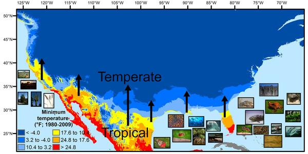
U.S. regions in the tropical-to-temperate transition
A map showing North America's tropical-to-temperate transition zone. Red, orange, and yellow depict the more tropical zones, and blues depict the more temperate zones, based on to the coldest recorded temperature for each area between 1980 and 2009.
A map showing North America's tropical-to-temperate transition zone. Red, orange, and yellow depict the more tropical zones, and blues depict the more temperate zones, based on to the coldest recorded temperature for each area between 1980 and 2009.

USGS hydrologist conducts equipment maintenance at streamgage
USGS hydrologist Adam Birken conducts equipment maintenance at the USGS streamgage on the South Fork of the Ogden River near Hunstville, Utah. This streamgage has been monitoring water levels and flow since March 21, 1921, making it one of 25 centennial gauges in Utah.
USGS hydrologist Adam Birken conducts equipment maintenance at the USGS streamgage on the South Fork of the Ogden River near Hunstville, Utah. This streamgage has been monitoring water levels and flow since March 21, 1921, making it one of 25 centennial gauges in Utah.

Utah Gauge Celebrates 100 Years of Monitoring Streamflow
A U.S. Geological Survey streamgage near Hunstville, Utah is celebrating 100 years of monitoring streamflow on the south fork of the Ogden River. The streamgage has been monitoring water levels and flow since March 21, 1921, making it one of 25 centennial gauges in Utah.
A U.S. Geological Survey streamgage near Hunstville, Utah is celebrating 100 years of monitoring streamflow on the south fork of the Ogden River. The streamgage has been monitoring water levels and flow since March 21, 1921, making it one of 25 centennial gauges in Utah.

Aerial photo of Cold River in Maine
Photo Contest Winner | March 2021 | Where We Work
Aerial photo of Cold River in Maine
Photo Contest Winner | March 2021 | Where We Work
Aerial photo of Cold River in Maine