
Aquatic ecosystems make a difference in the carbon cycle. The location in this photo is located near Beaver, Alaska approximately 100 miles north of Fairbanks.
Images
Explore our planet through photography and imagery, including climate change and water all the way back to the 1800s when the USGS was surveying the country by horse and buggy.
Filter Total Items: 21558

Aerial of Beaver Creek, Alaska
Aquatic ecosystems make a difference in the carbon cycle. The location in this photo is located near Beaver, Alaska approximately 100 miles north of Fairbanks.

Bar-tailed Godwit flock on Cape Avinof, western Alaska
Bar-tailed Godwit flock flying over the mudflats on Cape Avinof, western Alaska.
Bar-tailed Godwit flock flying over the mudflats on Cape Avinof, western Alaska.

Bar-tailed Godwits flying over mudflats near Cape Avinof, Alaska
Bar-tailed Godwits - photo taken on mudflats near Cape Avinof, Alaska. USGS and USFWS recently found that almost the entire population of Alaska-breeding bar-tailed godwits feed along sand bars near the mouth of the Kuskokwim River in autumn. These godwits spend the nonbreeding season primarily in eastern Australia an
Bar-tailed Godwits - photo taken on mudflats near Cape Avinof, Alaska. USGS and USFWS recently found that almost the entire population of Alaska-breeding bar-tailed godwits feed along sand bars near the mouth of the Kuskokwim River in autumn. These godwits spend the nonbreeding season primarily in eastern Australia an

Deposit of Iron-cemented Stream Gravel (Ferricrete)
Deposit of iron-cemented stream gravel (ferricrete) with embedded wood fragments that can be age dated using radiocarbon to determine the age of the ferricrete deposit. Knowing the age of the ferricretes helps scientists determine if the associated enrichment of metals in streams occurred before or after mining in the watershed started.
Deposit of iron-cemented stream gravel (ferricrete) with embedded wood fragments that can be age dated using radiocarbon to determine the age of the ferricrete deposit. Knowing the age of the ferricretes helps scientists determine if the associated enrichment of metals in streams occurred before or after mining in the watershed started.

Hawaiian Volcano Observatory field geologists track activity at fissure 8 (pictu
Hawaiian Volcano Observatory field geologists track activity at fissure 8 (pictured in the background). Crews collect fissure 8 tephra (Pele's hair, pumice, and other lightweight volcanic glass fragments) for geochemical analyses and characterization of changes in lava fountain behavior.
Hawaiian Volcano Observatory field geologists track activity at fissure 8 (pictured in the background). Crews collect fissure 8 tephra (Pele's hair, pumice, and other lightweight volcanic glass fragments) for geochemical analyses and characterization of changes in lava fountain behavior.

HVO on rim of Kīlauea's summit caldera overlooking Halema‘uma‘u, Ha...
The Hawaiian Volcano Observatory, the first volcano observatory in the United States, is located on the west rim of Kīlauea Volcano's summit caldera in Hawai‘i Volcanoes National Park. A volcanic gas plume rises from a vent that opened in 2008 at the base of the south wall of Halema‘uma‘u Crater. Crater Rim Drive in foreground.
The Hawaiian Volcano Observatory, the first volcano observatory in the United States, is located on the west rim of Kīlauea Volcano's summit caldera in Hawai‘i Volcanoes National Park. A volcanic gas plume rises from a vent that opened in 2008 at the base of the south wall of Halema‘uma‘u Crater. Crater Rim Drive in foreground.

HVO on rim of Kīlauea's summit caldera overlooking Halema‘uma‘u, Ha...
The U.S. Geological Survey's Hawaiian Volcano Observatory, the first volcano observatory in the United States, is located on the west rim of Kīlauea Volcano's summit caldera in Hawai‘i Volcanoes National Park. A volcanic gas plume rises from a vent that opened in 2008 at the base of the south wall of Halema‘uma‘u Crater. Crater Rim Drive in foreground.
The U.S. Geological Survey's Hawaiian Volcano Observatory, the first volcano observatory in the United States, is located on the west rim of Kīlauea Volcano's summit caldera in Hawai‘i Volcanoes National Park. A volcanic gas plume rises from a vent that opened in 2008 at the base of the south wall of Halema‘uma‘u Crater. Crater Rim Drive in foreground.

Protected Species Observer aboard CCGS Louis S. St-Laurent
Protected Species Observer aboard CCGS Louis S. St-Laurent
Protected Species Observer aboard CCGS Louis S. St-Laurent
The USGS Hawaiian Volcano Observatory Monitors Kilauea's Summit Eruption
The USGS Hawaiian Volcano Observatory (foreground) is located on the caldera rim of Kilauea Volcano, Hawai'ithe most active volcano in the world. The observatory's location provides an excellent view of summit eruptive activity, which began in 2008.
The USGS Hawaiian Volcano Observatory (foreground) is located on the caldera rim of Kilauea Volcano, Hawai'ithe most active volcano in the world. The observatory's location provides an excellent view of summit eruptive activity, which began in 2008.

USGS Hawaiian Volcano Observatory
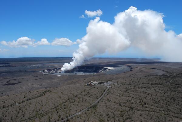
The USGS Hawaiian Volcano Observatory is perched on the rim of Kilauea Volcano's summit caldera (next to the Thomas A. Jaggar Museum in Hawai'i Volcanoes National Park), providing a spectacular view of the active vent in Halema‘uma‘u Crater.
The USGS Hawaiian Volcano Observatory is perched on the rim of Kilauea Volcano's summit caldera (next to the Thomas A. Jaggar Museum in Hawai'i Volcanoes National Park), providing a spectacular view of the active vent in Halema‘uma‘u Crater.

USGS Hawaiian Volcano Observatory Monitors Kilauea's Summit Eruption
The USGS Hawaiian Volcano Observatory (foreground) is located on the caldera rim of Kilauea Volcano, Hawai'i—the most active volcano in the world. The observatory's location provides an excellent view of summit eruptive activity, which began in 2008.
The USGS Hawaiian Volcano Observatory (foreground) is located on the caldera rim of Kilauea Volcano, Hawai'i—the most active volcano in the world. The observatory's location provides an excellent view of summit eruptive activity, which began in 2008.

USGS HVO, Kīlauea, Hawaii
The Hawaiian Volcano Observatory perched on the west rim of Kīlauea Volcano's summit caldera, overlooks Halema‘uma‘u Crater, where a new vent that opened in March 2008 emits a volcanic gas plume.
The Hawaiian Volcano Observatory perched on the west rim of Kīlauea Volcano's summit caldera, overlooks Halema‘uma‘u Crater, where a new vent that opened in March 2008 emits a volcanic gas plume.

Meandering Stream on the North Dakota Plains
A meandering stream that was a possible biomonitoring site for a USGS project in North Dakota.
A meandering stream that was a possible biomonitoring site for a USGS project in North Dakota.

Mineral Creek Watershed in Southwestern Colorado
Mineral Creek watershed in southwestern Colorado has natural and mining-related sources of contamination. In the background of this photo is a large naturally occurring seep that discharges acidic, metal-rich water to a tributary of Mineral Creek.
Mineral Creek watershed in southwestern Colorado has natural and mining-related sources of contamination. In the background of this photo is a large naturally occurring seep that discharges acidic, metal-rich water to a tributary of Mineral Creek.

Arctic Sea Ice
Image of sea ice along the Arctic Ocean.

Arctic Sea Ice
Image of sea ice along the Arctic Ocean.

Arctic Sea Ice
Image of sea ice along the Arctic Ocean.

Arctic Sea Ice
Image of sea ice along the Arctic Ocean.

Arctic Sea Ice
Image of sea ice along the Arctic Ocean. This image was taken while onboard U.S. Coast Guard Cutter Healy.
Image of sea ice along the Arctic Ocean. This image was taken while onboard U.S. Coast Guard Cutter Healy.

Arctic Sea Ice
Image of sea ice along the Arctic Ocean. This is the bow of U.S. Coast Guard Cutter Healy.
Image of sea ice along the Arctic Ocean. This is the bow of U.S. Coast Guard Cutter Healy.

Arctic Sea Ice
Image of sea ice along the Arctic Ocean.