
The rock formations and vegetation of Bryce Canyon National Park.
Images
Explore our planet through photography and imagery, including climate change and water all the way back to the 1800s when the USGS was surveying the country by horse and buggy.
Filter Total Items: 21558

Bryce Canyon National Park
The rock formations and vegetation of Bryce Canyon National Park.

Bryce Canyon National Park
The orange and white cliffs, rock formations, and vegetation of Bryce Canyon National Park.
The orange and white cliffs, rock formations, and vegetation of Bryce Canyon National Park.

Christmas Tree Farm
Southern Virginia farm of Christmas trees of various types.
Southern Virginia farm of Christmas trees of various types.

Distant View of Urban Landscape and Farms
View of urban landscape and farms from the top of a hill.
View of urban landscape and farms from the top of a hill.

Fountain of the Four Rivers
View of Fountain of the Four Rivers.
View of Fountain of the Four Rivers.

Italian Countryside
View of an Italian countryside that highlights the farmland. In the foreground are buildings and a road; in the background is a hill covered with trees.
View of an Italian countryside that highlights the farmland. In the foreground are buildings and a road; in the background is a hill covered with trees.

Italian Countryside
Farmland in a hilly Italian countryside.
Farmland in a hilly Italian countryside.

Italian Countryside
Hills behind buildings, farmland and a town.
Hills behind buildings, farmland and a town.

Italian Countryside
Hilly landscape dotted with buildings, farmland and a town.
Hilly landscape dotted with buildings, farmland and a town.

Italian Countryside
Distant view of hills and plains dotted with buildings.
Distant view of hills and plains dotted with buildings.

Italian Countryside
Countryside marked by farms, trees, and buildings.
Countryside marked by farms, trees, and buildings.

Italian Countryside
Bare hills of an Italian countryside.
Bare hills of an Italian countryside.

Italian Countryside
View of the Italian countryside through a brick tunnel.
View of the Italian countryside through a brick tunnel.

Italian Countryside
Farmland in a hilly Italian countryside.
Farmland in a hilly Italian countryside.

Italian Countryside
View of an Italian countryside that highlights the farmland. In the foreground are buildings and a road; in the background is a hill covered with trees.
View of an Italian countryside that highlights the farmland. In the foreground are buildings and a road; in the background is a hill covered with trees.

Ocean Cave
An ocean cave on the coast of Capri Island.
An ocean cave on the coast of Capri Island.

Kīlauea's east Lae‘apuki lava delta after 70-100 m (230-330 ft) lon...
Embayment of lava delta shows result of collapse. The initial collapse was large enough to send waves washing over much of the east half of the delta, because visibility was completely lost for almost 20 minutes, due to a steam white-out. Note rocky debris hurled by the waves onto the delta surface in foreground.
Embayment of lava delta shows result of collapse. The initial collapse was large enough to send waves washing over much of the east half of the delta, because visibility was completely lost for almost 20 minutes, due to a steam white-out. Note rocky debris hurled by the waves onto the delta surface in foreground.

Kīlauea's east Lae‘apuki lava delta pictured hours before it collap...
Kīlauea Volcano's east Lae‘apuki lava delta pictured hours before it collapsed into the sea over a 90-minute period. White plume marks location of lava entering sea fed by a lava tube within delta.
Kīlauea Volcano's east Lae‘apuki lava delta pictured hours before it collapsed into the sea over a 90-minute period. White plume marks location of lava entering sea fed by a lava tube within delta.

Loowit Falls flows north out of Mount St. Helens crater. White buil...
Loowit Falls flows north out of Mount St. Helens crater. White building in upper right corner is the Loowit gage house, which contains an Acoustic Flow Monitor.
Loowit Falls flows north out of Mount St. Helens crater. White building in upper right corner is the Loowit gage house, which contains an Acoustic Flow Monitor.

Lava spilling over sea cliff builds new lava delta, Kīlauea
pāhoehoe lava spilling over sea cliff on south coast of Kīlauea Volcano starts to build a new lava delta. Only three days old, the delta grows slowly as lava spreads over fragmented debris and flows that have accumulated on the steep submarine slope.
pāhoehoe lava spilling over sea cliff on south coast of Kīlauea Volcano starts to build a new lava delta. Only three days old, the delta grows slowly as lava spreads over fragmented debris and flows that have accumulated on the steep submarine slope.
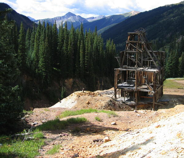
The Silver Ledge Mine in the Area of Upper Mineral Creek
The Silver Ledge Mine in the area of upper Mineral Creek, near Silverton, Colorado, is one of many abandoned mine sites in the watershed.
The Silver Ledge Mine in the area of upper Mineral Creek, near Silverton, Colorado, is one of many abandoned mine sites in the watershed.