
Another photo of the Pu‘u ‘Ō‘ō crater, this one looking northwest. In addition to flowing out of the crater to the southwest, lava has also been filling in the northeast side of the crater. Lava there is within 6 m (20 ft) of the crater rim. The gas plume from the vent at Kīlauea's summit is in the background.
Images
Volcano Hazard Program images.
Filter Total Items: 6226

Another photo of the Pu‘u ‘Ō‘ō, this one looking NW. In addition to...
Another photo of the Pu‘u ‘Ō‘ō crater, this one looking northwest. In addition to flowing out of the crater to the southwest, lava has also been filling in the northeast side of the crater. Lava there is within 6 m (20 ft) of the crater rim. The gas plume from the vent at Kīlauea's summit is in the background.

Starting in late June, the crater floor around the lava lake began ...
Starting in late June, the crater floor around the lava lake began to uplift. The photo here shows the flank of the east side of the lava lake. Prior to uplift, this steeply dipping surface was nearly flat-lying.
Starting in late June, the crater floor around the lava lake began to uplift. The photo here shows the flank of the east side of the lava lake. Prior to uplift, this steeply dipping surface was nearly flat-lying.

Pu‘u ‘Ō‘ō — Lava Lake
The lava lake within Pu‘u ‘Ō‘ō stands higher than the surrounding crater floor. The elevation of the lava lake surface is roughly even with the east rim of Pu‘u ‘Ō‘ō. This photo, from a slightly higher portion of the east rim, looks across the lava lake surface to the opposite lake rim.
The lava lake within Pu‘u ‘Ō‘ō stands higher than the surrounding crater floor. The elevation of the lava lake surface is roughly even with the east rim of Pu‘u ‘Ō‘ō. This photo, from a slightly higher portion of the east rim, looks across the lava lake surface to the opposite lake rim.

The lava accumulating on the SE side of the crater has begun to for...
The lava accumulating on the southeast side of the crater has begun to form a low shield that extends out from the crater and has buried the Puka Nui and MLK pits. Compare this photo to one taken last week (July 21) from the same spot.
The lava accumulating on the southeast side of the crater has begun to form a low shield that extends out from the crater and has buried the Puka Nui and MLK pits. Compare this photo to one taken last week (July 21) from the same spot.

Lava broke out from a vent on the west flank of Pu‘u ‘Ō‘ō cone
Around 2:20 p.m., HST, on August 3, lava broke out from a vent (center) low on the west flank of the Pu‘u ‘Ō‘ō cone. Lava erupting from the flank vent is entirely within Hawai‘i Volcanoes National Park, and pose no hazard to residents.
Around 2:20 p.m., HST, on August 3, lava broke out from a vent (center) low on the west flank of the Pu‘u ‘Ō‘ō cone. Lava erupting from the flank vent is entirely within Hawai‘i Volcanoes National Park, and pose no hazard to residents.

Lava flowing from vents of Pu‘u ‘Ō‘ō formed two branches
Lava flowing from vents on the west flank of Pu‘u ‘Ō‘ō formed two branches. A weak north arm advanced northward into forested kipuka (upper right). A higher-volume south arm quickly advanced down Kīlauea's south flank along the edge of flows erupted in 2002-2004 (upper left).
Lava flowing from vents on the west flank of Pu‘u ‘Ō‘ō formed two branches. A weak north arm advanced northward into forested kipuka (upper right). A higher-volume south arm quickly advanced down Kīlauea's south flank along the edge of flows erupted in 2002-2004 (upper left).

Rubble after collapse of Pu‘u ‘Ō‘ō floor and perched lava lake
At 2:02 p.m., HST, on August 3, the floor of Pu‘u ‘Ō‘ō crater, which had risen significantly over the past month, forming a dome beneath the perched lava lake, started to subside. By 3:15 p.m., the crater floor and perched lava lake began to collapse. Within a couple of hours, the lava lake was no longer visible, and the crater floor was covered in rubble.
At 2:02 p.m., HST, on August 3, the floor of Pu‘u ‘Ō‘ō crater, which had risen significantly over the past month, forming a dome beneath the perched lava lake, started to subside. By 3:15 p.m., the crater floor and perched lava lake began to collapse. Within a couple of hours, the lava lake was no longer visible, and the crater floor was covered in rubble.

Thermal images of vents and rubble-filled crater of Pu‘u ‘Ō‘ō
This thermal image, looking south, shows the individual vents feeding distinct channels.
This thermal image, looking south, shows the individual vents feeding distinct channels.

This thermal image, looking west, shows the rubble-filled crater of...
This thermal image, looking west, shows the rubble-filled crater of Pu‘u ‘Ō‘ō in the foreground, with the active flow field in the top half of the image.
This thermal image, looking west, shows the rubble-filled crater of Pu‘u ‘Ō‘ō in the foreground, with the active flow field in the top half of the image.

Broad area of ponded lava fed by two main channels
This view, looking east, shows the broad area of ponded lava fed by two main channels originating from several individual vents. The fume-filled crater of Pu‘u ‘Ō‘ō is in the background. The darker lava in the foreground, at the bottom of the image, is from the March 2011 Kamoamoa eruption.
This view, looking east, shows the broad area of ponded lava fed by two main channels originating from several individual vents. The fume-filled crater of Pu‘u ‘Ō‘ō is in the background. The darker lava in the foreground, at the bottom of the image, is from the March 2011 Kamoamoa eruption.

One of the more vigorous vents, in the lower left, is topped by a t...
One of the more vigorous vents, in the lower left, is topped by a tall (6 m, or 20 ft, high) spatter cone. The flow from this vent cascades down several steps, joining the flow from two other nearby vents, before flowing under a small bridge and into the broad area of ponded lava to the west.
One of the more vigorous vents, in the lower left, is topped by a tall (6 m, or 20 ft, high) spatter cone. The flow from this vent cascades down several steps, joining the flow from two other nearby vents, before flowing under a small bridge and into the broad area of ponded lava to the west.

Pu‘u ‘Ō‘ō, following the collapse of the crater floor on Aug. 3, ha...
Pu‘u ‘Ō‘ō crater, following the collapse of the crater floor on August 3, has been filled with thick fume. A very tiny flow, visible only with a thermal camera, was active on the crater floor.
Pu‘u ‘Ō‘ō crater, following the collapse of the crater floor on August 3, has been filled with thick fume. A very tiny flow, visible only with a thermal camera, was active on the crater floor.

This thermal image, looking SW, shows the very small flow, at the b...
This thermal image, looking southwest, shows the very small flow, at the bottom of the image, active in the bottom of Pu‘u ‘Ō‘ō crater. In the upper right, the active flows on the lower west flank of Pu‘u ‘Ō‘ō can be seen.
This thermal image, looking southwest, shows the very small flow, at the bottom of the image, active in the bottom of Pu‘u ‘Ō‘ō crater. In the upper right, the active flows on the lower west flank of Pu‘u ‘Ō‘ō can be seen.

The new lava lake in Pu‘u ‘Ō‘ō has buried much of the floor of Aug 4
The new lava lake in Pu‘u ‘Ō‘ō has buried much of the floor of the August 3, 2011, collapse crater beneath a maximum of about 45 m (~148 ft) of lava. Most of the lava upwells at the east end of the lake (lower right) and flows toward the west, much like the lava lake prior to the August 3 flank breakout and crater collapse.
The new lava lake in Pu‘u ‘Ō‘ō has buried much of the floor of the August 3, 2011, collapse crater beneath a maximum of about 45 m (~148 ft) of lava. Most of the lava upwells at the east end of the lake (lower right) and flows toward the west, much like the lava lake prior to the August 3 flank breakout and crater collapse.

The new lava lake has become slightly perched above the surrounding...
The new lava lake has become slightly perched above the surrounding crater floor, as shown by the distinct levees visible in this photo.
The new lava lake has become slightly perched above the surrounding crater floor, as shown by the distinct levees visible in this photo.

This photo, similar to previous, was taken from the same location a...
This photo, similar to the previous, was taken from the same location as photos posted on July 21 and June 9 (and several other dates scattered over the past several months) to provide a comparison to past activity in Pu‘u ‘Ō‘ō.
This photo, similar to the previous, was taken from the same location as photos posted on July 21 and June 9 (and several other dates scattered over the past several months) to provide a comparison to past activity in Pu‘u ‘Ō‘ō.

100-year-old descriptions still useful today
"The great inflated cylinder of black glass which formed over the sunken island, Aug. 18, 1911" (Frank Perret).
"The great inflated cylinder of black glass which formed over the sunken island, Aug. 18, 1911" (Frank Perret).

Stream channel cross-section measurements—instrument that uses lase...
Stream channel cross-section measurements—instrument that uses laser pulses to survey distance to a reflector operated by a second crew member, Mount St. Helens.
Stream channel cross-section measurements—instrument that uses laser pulses to survey distance to a reflector operated by a second crew member, Mount St. Helens.
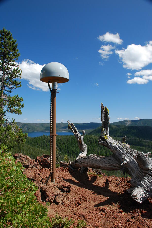
Global Positioning System receiver (called a GPS monument) at North...
Global Positioning System receiver (called a GPS monument) at North Rim Station, a monitoring location at Newberry volcano, Oregon.
Global Positioning System receiver (called a GPS monument) at North Rim Station, a monitoring location at Newberry volcano, Oregon.

Vents on the west flank of Pu‘u ‘Ō‘ō erupt—once again
August 3 photo showing the collapsed floor within Pu‘u ‘Ō‘ō Crater in the foreground and two lava flow branches each burning some forest—northwest branch to the right and south branch to the left.
August 3 photo showing the collapsed floor within Pu‘u ‘Ō‘ō Crater in the foreground and two lava flow branches each burning some forest—northwest branch to the right and south branch to the left.

HVO's first report in 1911—all about the Halema‘uma‘u lava lake
Frank Perret's photos from early July 1911 showing the island in the lake at the bottom of a smaller Halema‘uma‘u Crater. The view is looking southwest and the ledge up near the west rim was known as the January 1910 bench, a remnant of an earlier lava level in the crater.
Frank Perret's photos from early July 1911 showing the island in the lake at the bottom of a smaller Halema‘uma‘u Crater. The view is looking southwest and the ledge up near the west rim was known as the January 1910 bench, a remnant of an earlier lava level in the crater.