
Lava spatters above the fissure just west of the base of Pu‘u ‘Ō‘ō on March 6, 2011.
Images
Volcano Hazard Program images.
Filter Total Items: 6226

Looking back at the Kamoamoa fissure eruption
Lava spatters above the fissure just west of the base of Pu‘u ‘Ō‘ō on March 6, 2011.

InSAR image Kīlauea, Hawai‘i, Mar. 2011 shows ground surface deflat...
InSAR image Kīlauea, Hawai‘i, Mar. 2011. Kamoamoa fissure trace is indicated by the red line.
InSAR image Kīlauea, Hawai‘i, Mar. 2011. Kamoamoa fissure trace is indicated by the red line.

Village of Belacázar, adjacent to river Paez. Photo taken four year...
Village of Belacázar, adjacent to the river Paez. Photo taken four years after the 2008 lahar, but the trace of the deposit and destruction is still visible.
Village of Belacázar, adjacent to the river Paez. Photo taken four years after the 2008 lahar, but the trace of the deposit and destruction is still visible.

"Things are not always what they seem..."
As lava entered the sea in July 2008, littoral explosions sent incandescent lava fragments skyward, building a small littoral cone on the flank of Kīlauea. USGS photo by B. Gaddis.
As lava entered the sea in July 2008, littoral explosions sent incandescent lava fragments skyward, building a small littoral cone on the flank of Kīlauea. USGS photo by B. Gaddis.

Measuring volcanic gases with a Fourier transform infrared (FTIR) s...
Since the opening of the Overlook vent in Halema‘uma‘u Crater in 2008, FTIR spectroscopy has been used to monitor summit eruptive-gas composition. Infrared energy emitted by the lava lake surface (top left) is absorbed by gases present in the path between the instrument and the lak surface.
Since the opening of the Overlook vent in Halema‘uma‘u Crater in 2008, FTIR spectroscopy has been used to monitor summit eruptive-gas composition. Infrared energy emitted by the lava lake surface (top left) is absorbed by gases present in the path between the instrument and the lak surface.

Thousands were saved by accurate eruption forecasts of Mount Merapi...
Thousands were saved by accurate eruption forecasts of Mount Merapi, Indonesia. House in the village of Kopeng, 6 km (3.7 miles) from summit of Mount Merapi, destroyed by the explosive eruption.
Thousands were saved by accurate eruption forecasts of Mount Merapi, Indonesia. House in the village of Kopeng, 6 km (3.7 miles) from summit of Mount Merapi, destroyed by the explosive eruption.

SEM of ash particle from 2010 eruption of Eyjafjallajökull, Iceland
Blocky, non-vesicular ash particle indicative of water-magma interaction.
Blocky, non-vesicular ash particle indicative of water-magma interaction.

SEM Images of ash particles from 1989 eruption of Redoubt Volcano, AK
SEM Images of ash particles from the 1989 eruption of Redoubt Volcano, Alaska.
SEM Images of ash particles from the 1989 eruption of Redoubt Volcano, Alaska.

There's something in the way a volcano moves
An HVO scientist wearing a gas mask collects GPS data using a roving instrument on the west flank of Pu‘u ‘Ō‘ō. USGS Photo.
An HVO scientist wearing a gas mask collects GPS data using a roving instrument on the west flank of Pu‘u ‘Ō‘ō. USGS Photo.

Earthquakes provide warnings of volcanic activity
An HVO scientist and volunteer work to upgrade the power system of a seismic station located in the Ka‘ū desert on Kīlauea's southwest rift zone. USGS Photo.
An HVO scientist and volunteer work to upgrade the power system of a seismic station located in the Ka‘ū desert on Kīlauea's southwest rift zone. USGS Photo.
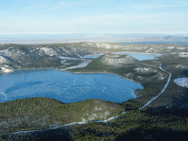
Aerial view of lakes and cinder cone at Newberry Volcano Caldera.
A view looking northeast across the central caldera of Newberry Volcano. Paulina Lake is in the foreground and East Lake is in the distance. The Central Pumice Cone lies between the two lakes. Near the bottom of the photo at the south edge of Paulina Lake, the two hills are named the Lakeshore Domes.
A view looking northeast across the central caldera of Newberry Volcano. Paulina Lake is in the foreground and East Lake is in the distance. The Central Pumice Cone lies between the two lakes. Near the bottom of the photo at the south edge of Paulina Lake, the two hills are named the Lakeshore Domes.

Gas sampling from a fumarole on the rim of Halema‘uma‘u within Kīla...
Gas sampling from a fumarole on the rim of Halema‘uma‘u Crater within Kīlauea caldera, Hawai‘i.
Gas sampling from a fumarole on the rim of Halema‘uma‘u Crater within Kīlauea caldera, Hawai‘i.

Geology provides the foundation for volcano monitoring
An HVO geologist uses GPS to map and track the progress of an ‘A‘ā lava flow in Royal Gardens subdivision in 2008. USGS photo.
An HVO geologist uses GPS to map and track the progress of an ‘A‘ā lava flow in Royal Gardens subdivision in 2008. USGS photo.

Fields with potential for volcano monitoring
An HVO scientist collects gravity data from a site on the rim of Kīlauea caldera. The active summit vent in Halema‘uma‘u Crater is visible in the background. USGS photo.
An HVO scientist collects gravity data from a site on the rim of Kīlauea caldera. The active summit vent in Halema‘uma‘u Crater is visible in the background. USGS photo.

Mount Baker's NEern face, WA.
Mount Baker's northeastern face, Washington.
Mount Baker's northeastern face, Washington.

Map of Kīlauea showing the south-SE motion, as recorded by continuo...
Map of Kīlauea Volcano showing the south-southeast motion, as recorded by continuous GPS sites (arrows), and earthquake epicenter between February 1-3, 2010.
Map of Kīlauea Volcano showing the south-southeast motion, as recorded by continuous GPS sites (arrows), and earthquake epicenter between February 1-3, 2010.

Volcanic monitoring types and methods employed by the USGS VHP.
Volcanic monitoring types and methods employed by the USGS Volcano Hazards Program.
Volcanic monitoring types and methods employed by the USGS Volcano Hazards Program.

Geologist describes activity from Kīlauea during a field trip to co...
HVO geologist describes activity from Kīlauea Volcano during a field trip to the coastal lava flow field for members of the media in 2010.
HVO geologist describes activity from Kīlauea Volcano during a field trip to the coastal lava flow field for members of the media in 2010.

Helicorder for Plate Boundary Observatory borehole seismometer B207...
Seismicity is shown for January 17, 2010 through the Feb 8, 2010. Borehole seismometer B207 is located about 7 miles (12 km) northeast of the 2010 swarm. Seismic data are provided by the National Science Foundation funded Plate Boundary Observatory operated by UNAVCO.
Seismicity is shown for January 17, 2010 through the Feb 8, 2010. Borehole seismometer B207 is located about 7 miles (12 km) northeast of the 2010 swarm. Seismic data are provided by the National Science Foundation funded Plate Boundary Observatory operated by UNAVCO.

Revisiting the 1919-1920 Mauna Iki eruption
Fast-moving lava flows erupted from Mauna Iki were hand-colored in this black-and-white photo taken on May 17, 1920. Historic photo courtesy of Roger and Barbara Myers.
Fast-moving lava flows erupted from Mauna Iki were hand-colored in this black-and-white photo taken on May 17, 1920. Historic photo courtesy of Roger and Barbara Myers.

Suspended sediment sample collection from the North Fork Toutle Riv...
Suspended sediment sample collection from the North Fork Toutle River above the Sediment Retention Structure, downstream from Mount St. Helens.
Suspended sediment sample collection from the North Fork Toutle River above the Sediment Retention Structure, downstream from Mount St. Helens.