
A telephoto view looking southwest taken during a helicopter overflight on the morning of March 29, 2022, of the Kamakaiʻa Hills of Kīlauea's Southwest Rift Zone. Geologic mapping efforts indicate that the Kamakaiʻa Hills likely erupted within the last 250 years. The southwest flank of Mauna Loa is faint in the distant background to the right. USGS photo by N.
Images
Volcano Hazard Program images.
Filter Total Items: 6226

March 29, 2022 — Kamakaiʻa Hills
A telephoto view looking southwest taken during a helicopter overflight on the morning of March 29, 2022, of the Kamakaiʻa Hills of Kīlauea's Southwest Rift Zone. Geologic mapping efforts indicate that the Kamakaiʻa Hills likely erupted within the last 250 years. The southwest flank of Mauna Loa is faint in the distant background to the right. USGS photo by N.

March 29, 2022 — Kīlauea Iki Crater, Pu‘upua‘i, and Keanakāko‘i Crater
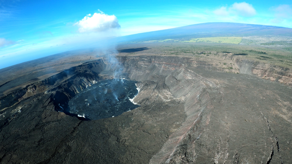
A photograph taken during a helicopter overflight on the morning of March 29, 2022, with views of Kīlauea Iki Crater (top left), Pu‘upua‘i (left), and Keanakāko‘i Crater (bottom right). Pu‘upua‘i is a large cinder cone that during the 1959 eruption of Kīlauea Iki. The trail leading to a popular viewing area for the current eruption is visible in the bottom center.
A photograph taken during a helicopter overflight on the morning of March 29, 2022, with views of Kīlauea Iki Crater (top left), Pu‘upua‘i (left), and Keanakāko‘i Crater (bottom right). Pu‘upua‘i is a large cinder cone that during the 1959 eruption of Kīlauea Iki. The trail leading to a popular viewing area for the current eruption is visible in the bottom center.

March 25, 2022 — Kīlauea summit continued lava lake activity
The summit eruption in Halema‘uma‘u crater, at the summit of Kīlauea, continues with lava lake activity. This photo, taken on March 24, 2022, shows lava from the main lake pouring into a smaller lake in the western portion of the crater. USGS image by M. Patrick.
The summit eruption in Halema‘uma‘u crater, at the summit of Kīlauea, continues with lava lake activity. This photo, taken on March 24, 2022, shows lava from the main lake pouring into a smaller lake in the western portion of the crater. USGS image by M. Patrick.

March 22, 2022 — Kīlauea Keller Well sampling
On March 22, USGS Hawaiian Volcano Observatory Scientists measured the water level in Keller Well, located in Kīlauea's south caldera region. Scientists also obtained a water sample. Keller Well is measured and sampled quarterly to monitor how magma supply to Kīlauea's summit reservoirs might impact regional ground water.
On March 22, USGS Hawaiian Volcano Observatory Scientists measured the water level in Keller Well, located in Kīlauea's south caldera region. Scientists also obtained a water sample. Keller Well is measured and sampled quarterly to monitor how magma supply to Kīlauea's summit reservoirs might impact regional ground water.

March 22, 2022 — Kīlauea Keller Well sampling
Located south of Halema‘uma‘u crater, in Kīlauea south caldera region, the Keller Well is a borehole drilled in 1973 to a depth of 4,140 ft (1,262 m). Hawaii Volcano Observatory geologists measure the depth to the water table quarterly to monitor Kīlauea summit region hydrology. Photo taken on March 22, 2022, by F. Younger.
Located south of Halema‘uma‘u crater, in Kīlauea south caldera region, the Keller Well is a borehole drilled in 1973 to a depth of 4,140 ft (1,262 m). Hawaii Volcano Observatory geologists measure the depth to the water table quarterly to monitor Kīlauea summit region hydrology. Photo taken on March 22, 2022, by F. Younger.

Absolute Quantum Gravimeter
The USGS Hawaiian Volcano Observatory’s Absolute Quantum Gravimeter is undergoing set-up, testing, and calibration before installation at the summit of Kīlauea. USGS image by A. Ellis.
The USGS Hawaiian Volcano Observatory’s Absolute Quantum Gravimeter is undergoing set-up, testing, and calibration before installation at the summit of Kīlauea. USGS image by A. Ellis.

March 17, 2022 — Overview of Halema‘uma‘u, Kīlauea
A photograph taken during a helicopter overflight on the morning of March 17, 2022, shows an overview of Halema‘uma‘u and a diffuse plume rising above Kīlauea caldera.
A photograph taken during a helicopter overflight on the morning of March 17, 2022, shows an overview of Halema‘uma‘u and a diffuse plume rising above Kīlauea caldera.

March 17, 2022 — Kīlauea Iki and Pu‘upua‘i.
A photograph taken during a helicopter overflight on the morning of March 17, 2022, shows an overview of Kīlauea Iki and Pu‘u Pua‘i. Pu‘u Pua‘i is a large cinder cone that formed as a result of the towering 1,900 foot (580 meters) lava fountains during the eruption of Kīlauea Iki.
A photograph taken during a helicopter overflight on the morning of March 17, 2022, shows an overview of Kīlauea Iki and Pu‘u Pua‘i. Pu‘u Pua‘i is a large cinder cone that formed as a result of the towering 1,900 foot (580 meters) lava fountains during the eruption of Kīlauea Iki.
March 17, 2022 — Kīlauea summit eruption overflight
A routine helicopter overflight on March 17, 2022, provided airborne views of the summit eruption in Halema‘uma‘u crater, at the summit of Kīlauea. At the start of the video, the helicopter flies over the edge of the large collapse depression formed during the 2018 eruption.
A routine helicopter overflight on March 17, 2022, provided airborne views of the summit eruption in Halema‘uma‘u crater, at the summit of Kīlauea. At the start of the video, the helicopter flies over the edge of the large collapse depression formed during the 2018 eruption.

March 17, 2022—Kīlauea summit thermal map
A helicopter overflight on March 17, 2022, allowed for aerial visual and thermal imagery to be collected of Halema‘uma‘u crater at the summit of Kīlauea. The active lake surface is limited to the western portion of the crater.
A helicopter overflight on March 17, 2022, allowed for aerial visual and thermal imagery to be collected of Halema‘uma‘u crater at the summit of Kīlauea. The active lake surface is limited to the western portion of the crater.

March 21, 2022—Kīlauea summit eruption reference map
This reference map depicts the ongoing Kīlauea summit eruption on March 21, 2022. One eruptive vent is intermittently active within Halema‘uma‘u, in the western end of the crater. When this vent is effusing lava, it pours into a lava lake, colored red on this map.
This reference map depicts the ongoing Kīlauea summit eruption on March 21, 2022. One eruptive vent is intermittently active within Halema‘uma‘u, in the western end of the crater. When this vent is effusing lava, it pours into a lava lake, colored red on this map.

March 15, 2022 — Kīlauea arch of lava
This 8 meter (26 feet) tall arch of lava was left behind during a lull in eruptive activity within Halema‘uma‘u crater, at Kīlauea's summit. This feature is located in the spillway that connects the vent of Halema‘uma‘u to the lava lake.
This 8 meter (26 feet) tall arch of lava was left behind during a lull in eruptive activity within Halema‘uma‘u crater, at Kīlauea's summit. This feature is located in the spillway that connects the vent of Halema‘uma‘u to the lava lake.

Halema‘uma‘u, Kīlauea summit - March 11, 2022
A view of Halema‘uma‘u at Kīlauea summit, looking east, on the morning of March 11. The active lava lake is silvery gray and is visible in the lower right. The remnants of the west vent cone area are visible to the west (bottom right) of the active lava lake, and are the source of the majority of bluish-white volcanic gas emissions. USGS image by N. Deligne.
A view of Halema‘uma‘u at Kīlauea summit, looking east, on the morning of March 11. The active lava lake is silvery gray and is visible in the lower right. The remnants of the west vent cone area are visible to the west (bottom right) of the active lava lake, and are the source of the majority of bluish-white volcanic gas emissions. USGS image by N. Deligne.

Kīlauea active lava lake - March 11, 2022
Telephoto view looking east of the active lava lake within Halema‘uma‘u crater at the summit of Kīlauea on March 11, 2022. The craggy remains of the west vent cone, which has broken down over the past few weeks, are visible through the volcanic gas plume in the lower right.
Telephoto view looking east of the active lava lake within Halema‘uma‘u crater at the summit of Kīlauea on March 11, 2022. The craggy remains of the west vent cone, which has broken down over the past few weeks, are visible through the volcanic gas plume in the lower right.

Kīlauea active lava lake - March 11, 2022
Telephoto view, looking east, of the lava source area for the active lava lake within Halema‘uma‘u at the summit of Kīlauea on March 11. The is supplied from the embayment which is just north (left) of the remnants of west cone area (center and right).
Telephoto view, looking east, of the lava source area for the active lava lake within Halema‘uma‘u at the summit of Kīlauea on March 11. The is supplied from the embayment which is just north (left) of the remnants of west cone area (center and right).

Changes to the west vent area in Halema‘uma‘u over the past month
This animated gif features one V1cam image, taken around noon each day, from February 1, 2022, through March 4, 2022.
This animated gif features one V1cam image, taken around noon each day, from February 1, 2022, through March 4, 2022.

March 4, 2022 — Kīlauea
Bursts of lava erupting from a vent in the western half of Halema‘uma‘u crater, at Kīlauea volcano summit, were reaching 15-20 meters (50-65 feet) from the top of the cone on March 4, 2022. A small channel of sluggish lava was flowing down the western side of this cone.
Bursts of lava erupting from a vent in the western half of Halema‘uma‘u crater, at Kīlauea volcano summit, were reaching 15-20 meters (50-65 feet) from the top of the cone on March 4, 2022. A small channel of sluggish lava was flowing down the western side of this cone.

March 4, 2022 — Kīlauea
Kīlauea's summit eruption continues within Halema‘uma‘u crater. A number of vents are located in the western half of the crater, where the west vent cone used to be. On March 4, 2022, the highest of these features was measured at 19 meters (60 feet) in height and is shown in this photograph. USGS photo by L. Gallant.
Kīlauea's summit eruption continues within Halema‘uma‘u crater. A number of vents are located in the western half of the crater, where the west vent cone used to be. On March 4, 2022, the highest of these features was measured at 19 meters (60 feet) in height and is shown in this photograph. USGS photo by L. Gallant.

March 4, 2022 — Kīlauea
The ongoing eruption in Halema‘uma‘u, at Kīlauea summit, is occurring from a number of vents in a complex located in the western half of the crater. The tallest cone in this complex measures about 19 meters (60 feet) in height and is shown in this photograph. USGS photo by L. Gallant.
The ongoing eruption in Halema‘uma‘u, at Kīlauea summit, is occurring from a number of vents in a complex located in the western half of the crater. The tallest cone in this complex measures about 19 meters (60 feet) in height and is shown in this photograph. USGS photo by L. Gallant.

March 4, 2022—Kīlauea summit eruption reference map
This reference map depicts the ongoing Kīlauea summit eruption on March 4, 2022. One eruptive vent is intermittently active within Halema‘uma‘u, in the western end of the crater. When this vent is effusing lava, it pours into a lava lake, colored red on this map.
This reference map depicts the ongoing Kīlauea summit eruption on March 4, 2022. One eruptive vent is intermittently active within Halema‘uma‘u, in the western end of the crater. When this vent is effusing lava, it pours into a lava lake, colored red on this map.