
ANIMATED GIF: The KWcam webcam has been imaging the Kīlauea summit water lake for just over a year now, tracking visual changes in the lake including water level and color.
Images
Volcano Hazard Program images.
Filter Total Items: 6226

Kīlauea summit water lake KW webcam images 11-1-2019 to 10-30-2020
ANIMATED GIF: The KWcam webcam has been imaging the Kīlauea summit water lake for just over a year now, tracking visual changes in the lake including water level and color.

Kīlauea summit water lake KW webcam images 11-1-2019 to 10-30-2020
ANNIMATED GIF: This animated image file (GIF) of the Kīlauea summit water lake is a cropped version this file, showing a close-up view of the lake.
ANNIMATED GIF: This animated image file (GIF) of the Kīlauea summit water lake is a cropped version this file, showing a close-up view of the lake.

This photo looks north along the broad Fissure 8 channel. At its widest section
This photo looks north along the broad Fissure 8 channel. At its widest section, the Fissure 8 channel is about 430 meters (1400 feet wide). In the upper right section of the photo, Highway 132 can be seen cutting through the braided section of the channel. USGS photo by M. Zoeller.
This photo looks north along the broad Fissure 8 channel. At its widest section, the Fissure 8 channel is about 430 meters (1400 feet wide). In the upper right section of the photo, Highway 132 can be seen cutting through the braided section of the channel. USGS photo by M. Zoeller.

A closer view of the braided section of the Fissure 8 channel, with Highway 132
A closer view of the braided section of the Fissure 8 channel, with Highway 132 cutting across both branches. USGS photo by M. Zoeller.
A closer view of the braided section of the Fissure 8 channel, with Highway 132 cutting across both branches. USGS photo by M. Zoeller.

Dan Dzurisin
Dan Dzurisin, of the Cascades Volcano Observatory, conducting a leveling survey at Newberry Volcano, Oregon, in 2002.
Dan Dzurisin, of the Cascades Volcano Observatory, conducting a leveling survey at Newberry Volcano, Oregon, in 2002.

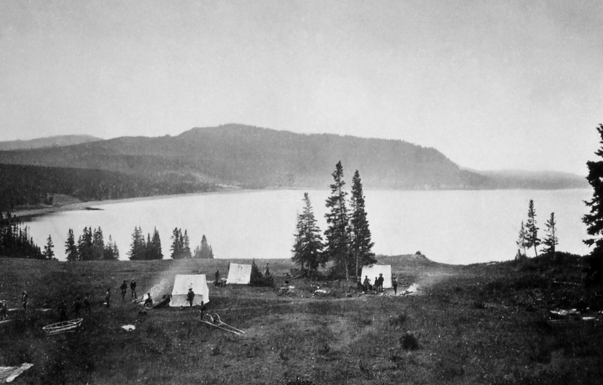
"Earthquake camp" of the Hayden expedition in 1871, located on the north shore o
"Earthquake camp" of the Hayden expedition in 1871, located on the north shore of Yellowstone Lake near Steamboat Point. Photo by William H. Jackson, courtesy Yellowstone National Park (https://www.nps.gov/features/yell/slidefile/history/jacksonphotos/Image…).
"Earthquake camp" of the Hayden expedition in 1871, located on the north shore of Yellowstone Lake near Steamboat Point. Photo by William H. Jackson, courtesy Yellowstone National Park (https://www.nps.gov/features/yell/slidefile/history/jacksonphotos/Image…).

Jo Schmith examining ash from Katla volcano in Iceland
Jo Schmith examining ash from Katla volcano in Iceland.
Jo Schmith examining ash from Katla volcano in Iceland.

Earthquake hazard map showing peak ground accelerations having a 2 percent proba
Earthquake hazard map showing peak ground accelerations having a 2 percent probability of being exceeded in 50 years, for a firm rock site. Black box outlines Yellowstone region. The map is based on the most recent USGS models for the conterminous U.S. (2018), Hawaii (1998), and Alaska (2007).
Earthquake hazard map showing peak ground accelerations having a 2 percent probability of being exceeded in 50 years, for a firm rock site. Black box outlines Yellowstone region. The map is based on the most recent USGS models for the conterminous U.S. (2018), Hawaii (1998), and Alaska (2007).

Yellowstone earthquakes that occurred during 2010-2019. Blue symbols indicate e
Yellowstone earthquakes that occurred during 2010-2019. Blue symbols indicate events that occurred as part of swarms, while red indicates non-swarm seismicity. Map courtesy of the University of Utah Seismograph Stations.
Yellowstone earthquakes that occurred during 2010-2019. Blue symbols indicate events that occurred as part of swarms, while red indicates non-swarm seismicity. Map courtesy of the University of Utah Seismograph Stations.

Mount Rainier: Earthquakes in the Hydrothermal System
Earthquakes at Mount Rainier from 2010 to 2019. As shown in the graphic, fluids from the magmatic system beneath the volcano rise through existing cracks and weaknesses in the crust. Along with rainwater and ice/snow melt, these fluids combine to create a hydrothermal system within the volcano.
Earthquakes at Mount Rainier from 2010 to 2019. As shown in the graphic, fluids from the magmatic system beneath the volcano rise through existing cracks and weaknesses in the crust. Along with rainwater and ice/snow melt, these fluids combine to create a hydrothermal system within the volcano.

December 18, 2019 thermal image of Kīlauea summit
The December 18 overflight provided updated thermal images of Kīlauea summit, covering the caldera floor and showing the warm surface of the water pond in Halema‘uma‘u crater. A band of warm temperatures persists along the new cliff formed during the 2018 subsidence.
The December 18 overflight provided updated thermal images of Kīlauea summit, covering the caldera floor and showing the warm surface of the water pond in Halema‘uma‘u crater. A band of warm temperatures persists along the new cliff formed during the 2018 subsidence.

December 18, 2019 aerial map of Kīlauea summit
The December 18, 2019, overflight provided updated aerial photographs of Kīlauea summit, covering the caldera floor and showing the current size of the water pond in Halema‘uma‘u crater.
The December 18, 2019, overflight provided updated aerial photographs of Kīlauea summit, covering the caldera floor and showing the current size of the water pond in Halema‘uma‘u crater.

Halema‘uma‘u water lake at the summit of Kīlauea Volcano
The growing lake of groundwater within Halema‘uma‘u at the summit of Kīlauea Volcano as it looked on December 18, 2019.
The growing lake of groundwater within Halema‘uma‘u at the summit of Kīlauea Volcano as it looked on December 18, 2019.

Mount Konocti as seen from the town of Clear Lake.
Mount Konocti as seen from the town of Clear Lake.
Mount Konocti as seen from the town of Clear Lake.

Thurston Lake and Mount Konocti, Clear Lake Volcanic Field
Thurston Lake and Mount Konocti, Clear Lake Volcanic Field, California.
Thurston Lake and Mount Konocti, Clear Lake Volcanic Field, California.

Beryl Spring's strongly boiling blue pool contains high-chloride liquid water wi
Beryl Spring's strongly boiling blue pool is about 8 m (25 ft) wide and contains high-chloride liquid water with a near-neutral pH. Immediately behind the pool is a loud, hissing fumarole producing a white cloud of steam. USGS Photo by Pat Shanks, 2002.
Beryl Spring's strongly boiling blue pool is about 8 m (25 ft) wide and contains high-chloride liquid water with a near-neutral pH. Immediately behind the pool is a loud, hissing fumarole producing a white cloud of steam. USGS Photo by Pat Shanks, 2002.

Imperial Geyser looking south
Imperial Geyser looking south. This hot spring pool is about 30 m (about 100 ft) across and contains alkaline-Cl waters with a steam vent in the pool and mudpots outside the pool area (in the upper right part of this photo). USGS Photo by Pat Shanks, 2019.
Imperial Geyser looking south. This hot spring pool is about 30 m (about 100 ft) across and contains alkaline-Cl waters with a steam vent in the pool and mudpots outside the pool area (in the upper right part of this photo). USGS Photo by Pat Shanks, 2019.

Volcano Awareness Month 2020
Volcano Awareness Month programs offered in January 2020 are depicted by these images. Clockwise from top left: ground cracks opened at HVO's former location atop Kīlauea in 2018; fissure erupting on Mauna Loa in March 1984; crater lake within Halema‘uma‘u at Kīlauea's summit; and visitors hiking a Kahuku trail in Hawai‘i Volcanoes National Park (NPS).
Volcano Awareness Month programs offered in January 2020 are depicted by these images. Clockwise from top left: ground cracks opened at HVO's former location atop Kīlauea in 2018; fissure erupting on Mauna Loa in March 1984; crater lake within Halema‘uma‘u at Kīlauea's summit; and visitors hiking a Kahuku trail in Hawai‘i Volcanoes National Park (NPS).

2020 Volcano Awareness Month—Schedule Overview
2020 Volcano Awareness Month Schedule Overview. Details are posted on the USGS-Hawaiian Volcano Observatory's website at https://volcanoes.usgs.gov/observatories/hvo/.
2020 Volcano Awareness Month Schedule Overview. Details are posted on the USGS-Hawaiian Volcano Observatory's website at https://volcanoes.usgs.gov/observatories/hvo/.

USGS HVO geophysicist Jefferson Chang presenting
USGS Hawaiian Volcano Observatory geophysicist Jefferson Chang during his presentation at the 2019 National Diversity in STEM Conference in Honolulu. Chang and Kevan Kamibayashi (left) were two of four HVO scientists who spoke about their work monitoring Hawaiian volcanoes at the SACNAS conference.
USGS Hawaiian Volcano Observatory geophysicist Jefferson Chang during his presentation at the 2019 National Diversity in STEM Conference in Honolulu. Chang and Kevan Kamibayashi (left) were two of four HVO scientists who spoke about their work monitoring Hawaiian volcanoes at the SACNAS conference.

Map of seismicity in the Yellowstone region during 2019.
Map of seismicity (yellow circles) in the Yellowstone region during 2019. Gray lines are roads, red line shows the caldera boundary, Yellowstone National Park is outlined by black dashed line, and gray dashed lines denote state boundaries.
Map of seismicity (yellow circles) in the Yellowstone region during 2019. Gray lines are roads, red line shows the caldera boundary, Yellowstone National Park is outlined by black dashed line, and gray dashed lines denote state boundaries.