
Maximum current speeds for the Port of Los Angeles (POLA) and the Port of Long Beach (POLB) generated during the SAFRR tsunami scenario. The ports are protected by a breakwater, but during the tsunami there would be dangerously fast currents around the port entrances in the wall, locally referred to as “Angels Gate” (at POLA) and “Queens Gate” (at POLB).
Images
Images intro.
Filter Total Items: 2135

SAFRR tsunami scenario for ports
Maximum current speeds for the Port of Los Angeles (POLA) and the Port of Long Beach (POLB) generated during the SAFRR tsunami scenario. The ports are protected by a breakwater, but during the tsunami there would be dangerously fast currents around the port entrances in the wall, locally referred to as “Angels Gate” (at POLA) and “Queens Gate” (at POLB).

Catsharks on Billy Mitchell shipwreck
Hundreds of catsharks, or chainlink dogfish, rest on one of the "Billy Mitchell" Fleet shipwrecks. The shipwreck has also been occupied by colonies of anemones, starfish, and hydroids.
Hundreds of catsharks, or chainlink dogfish, rest on one of the "Billy Mitchell" Fleet shipwrecks. The shipwreck has also been occupied by colonies of anemones, starfish, and hydroids.

Scientists prepare to extract push core sediment sample
U.S. Geological Survey scientists (left to right) Jennifer McClain-Counts, Jill Bourque, and Amanda Demopoulos prepare to extract a sediment sample from one of the push cores deployed by the Jason II remotely operated vehicle.
U.S. Geological Survey scientists (left to right) Jennifer McClain-Counts, Jill Bourque, and Amanda Demopoulos prepare to extract a sediment sample from one of the push cores deployed by the Jason II remotely operated vehicle.

Squat lobster rests on coral and sponge
Deep-sea coral communities can be very diverse. Here a squat lobster rests among a bubblegum coral, a red tree coral, and a sponge. A brisingid seastar arm is also visible.
Deep-sea coral communities can be very diverse. Here a squat lobster rests among a bubblegum coral, a red tree coral, and a sponge. A brisingid seastar arm is also visible.

Sites visited during Northeast US Canyons Expedition
Sites visited by the National Oceanic and Atmospheric Administration (NOAA) remotely operated vehicle (ROV) Deep Discoverer (D2) during the two legs of the Northeast U.S. Canyons Expedition 2013.
Sites visited by the National Oceanic and Atmospheric Administration (NOAA) remotely operated vehicle (ROV) Deep Discoverer (D2) during the two legs of the Northeast U.S. Canyons Expedition 2013.

Assemblage of invertebrates living on a steep submarine canyon wall
Assemblage of invertebrates living on a steep submarine canyon wall, seen during the Deepwater Canyons 2013 - Pathways to the Abyss.
Assemblage of invertebrates living on a steep submarine canyon wall, seen during the Deepwater Canyons 2013 - Pathways to the Abyss.

Deep-Sea Coral: Brisingid Starfish
A bright orange Brisingid starfish is seen in the center of the image. The background is a thicket of live (white) and dead (brown) Lophelia coral. Several squat lobsters (Eumunida picta) can be seen in the coral, as well as a blue encrusting sponge and an urchin (foreground, lower left).
A bright orange Brisingid starfish is seen in the center of the image. The background is a thicket of live (white) and dead (brown) Lophelia coral. Several squat lobsters (Eumunida picta) can be seen in the coral, as well as a blue encrusting sponge and an urchin (foreground, lower left).

Shaded relief image of Vineyard Sound, MA Shoals
Shaded relief image of Vineyard Sound, MA Shoals
Shaded relief image of Vineyard Sound, MA Shoals

USGS technicians prepare a sediment trap
USGS technicians prepare a sediment trap to sample the sea floor off Cape Hatteras.
USGS technicians prepare a sediment trap to sample the sea floor off Cape Hatteras.

Sampling seep gas through the ice in Lake Qalluuraq, Barrow Alaska
USGS research chemist John Pohlman samples seep gas through ice in Lake Qalluuraq, located in continuous permafrost approximately 97 kilometers (60 miles) south of Barrow, Alaska.
USGS research chemist John Pohlman samples seep gas through ice in Lake Qalluuraq, located in continuous permafrost approximately 97 kilometers (60 miles) south of Barrow, Alaska.

Photo of the seafloor in Block Island Sound, Rhode Island
Photo of the seafloor in Block Island Sound showing a rock crab and several shrimp on a boulder that is covered with bryozoans. The photo was collected in support of research and management activities (e.g., wind farms and fisheries) along the Rhode Island inner continental shelf.
Photo of the seafloor in Block Island Sound showing a rock crab and several shrimp on a boulder that is covered with bryozoans. The photo was collected in support of research and management activities (e.g., wind farms and fisheries) along the Rhode Island inner continental shelf.

sonar on a bottom platform
A sonar on a bottom platform while steaming to the deployment site in the Columbia River in 2013. The 3 platforms acquired data on currents and sediment transport at the river mouth over several months.
A sonar on a bottom platform while steaming to the deployment site in the Columbia River in 2013. The 3 platforms acquired data on currents and sediment transport at the river mouth over several months.

Deploying multichannel seismic streamer
Eric Moore, Wayne Baldwin, and Tommy O’Brien are deploying multichannel seismic streamer onboard R/V Pelican during a 2013 seismic cruise in the Gulf of Mexico as part of the gas hydrates program.
Eric Moore, Wayne Baldwin, and Tommy O’Brien are deploying multichannel seismic streamer onboard R/V Pelican during a 2013 seismic cruise in the Gulf of Mexico as part of the gas hydrates program.

Weather buoy transport!
Sandy Brosnahan transporting a weather buoy into the Woods Hole Coastal and Marine Science Center’s operational facility to continue the process of getting it ready to deploy. This buoy was one of 6, deployed by John Warner and others, to measure wind speed, direction, pressure, and temperature off the coast of Fire Island, NY. Paired with each weather b
Sandy Brosnahan transporting a weather buoy into the Woods Hole Coastal and Marine Science Center’s operational facility to continue the process of getting it ready to deploy. This buoy was one of 6, deployed by John Warner and others, to measure wind speed, direction, pressure, and temperature off the coast of Fire Island, NY. Paired with each weather b

Estuarine salt marsh of San Francisco Bay
Photo for upcoming seminar titled, “Sediment delivery across the bay-marsh interface of an estuarine salt marsh,” by Jessie Lacy.
Photo for upcoming seminar titled, “Sediment delivery across the bay-marsh interface of an estuarine salt marsh,” by Jessie Lacy.

Rocky and Sandy Seafloor Offshore California
Image of ripples in sand, next to a rocky surface on the seafloor 2.5 km (1.5 miles) offshore San Mateo County, California at a depth of 24.6 meters (81 feet). The two red dots in the image (from lasers mounted on the camera and used as reference points) are 15 cm (6 inches) apart.
Image of ripples in sand, next to a rocky surface on the seafloor 2.5 km (1.5 miles) offshore San Mateo County, California at a depth of 24.6 meters (81 feet). The two red dots in the image (from lasers mounted on the camera and used as reference points) are 15 cm (6 inches) apart.

USGS diver taking a core of a 100-year-old coral in USVI
USGS diver taking a core of a 100-year-old coral to allow reconstruction of past ocean temperatures in St. Thomas, U.S. Virgin Islands.
USGS diver taking a core of a 100-year-old coral to allow reconstruction of past ocean temperatures in St. Thomas, U.S. Virgin Islands.

PCMSC research vessel Karluk
PCMSC research vessel Karluk
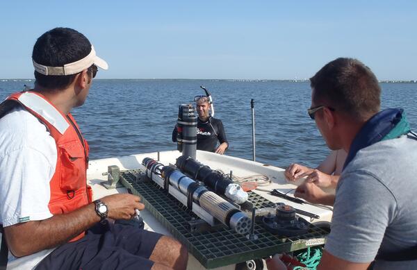
Shallow Water Irradience Platform placement in Barnegat Bay, NJ
Investigators prepare to place a Shallow Water Irradience Platform (SWIP) at a site in Barnegat Bay, NJ.
Investigators prepare to place a Shallow Water Irradience Platform (SWIP) at a site in Barnegat Bay, NJ.

Salt Marsh Research
USGS research supports wetland conservation as critical habitat, Cape Cod, MA
USGS research supports wetland conservation as critical habitat, Cape Cod, MA

USGS and Summer Interns from the Partnership Education Program (PEP) p
USGS and Summer Interns from the Partnership Education Program (PEP) program sampling over a tidal cycle.
USGS and Summer Interns from the Partnership Education Program (PEP) program sampling over a tidal cycle.