
Photograph of the seafloor off the California coast showing coarse sand, shells, and a sunflower sea star. It was taken during a "ground-truthing" survey off of Salt Point, California, in support of the California Seafloor Mapping Program.
Images
Images intro.
Filter Total Items: 2135

Sunflower sea star on the seafloor
Photograph of the seafloor off the California coast showing coarse sand, shells, and a sunflower sea star. It was taken during a "ground-truthing" survey off of Salt Point, California, in support of the California Seafloor Mapping Program.
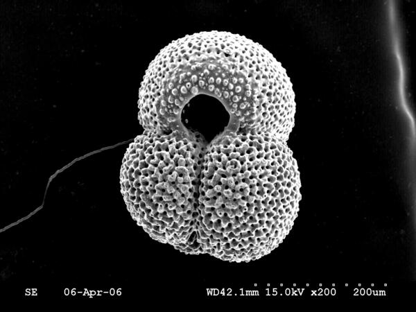
Scanning electron microsope image of the planktic foram Globiger ruber
Scanning electron microsope image of the planktic foraminifer Globigerinoides ruber
Scanning electron microsope image of the planktic foraminifer Globigerinoides ruber

Fish and coral in Tumon Bay Marine Reserve, Guam
Underwater photograph of Tumon Bay Marine Reserve, Guam, showing some of the amazing biologic diversity of coral reefs.
Underwater photograph of Tumon Bay Marine Reserve, Guam, showing some of the amazing biologic diversity of coral reefs.

Natural Bridges State Beach, Santa Cruz, California
Photograph of the coastal region of Natural Bridges State Beach in Santa Cruz, California
Photograph of the coastal region of Natural Bridges State Beach in Santa Cruz, California

Bathymetry surrounding Martha's Vineyard, MA
Oblique hillshaded-relief view of the bathymetry surrounding Martha’s Vineyard and the Upper Cape looking south across Buzzards Bay and Vineyard Sound
Oblique hillshaded-relief view of the bathymetry surrounding Martha’s Vineyard and the Upper Cape looking south across Buzzards Bay and Vineyard Sound

Southern Gulf of Maine and Massachusetts coastal zone bathymetry
Image showing the bathymetry of the southern Gulf of Maine with the Massachusetts coastal zone boundary outlined in grey. The images on the right display how the geophysical and sample data are combined to create an interpretation of seafloor geology
Image showing the bathymetry of the southern Gulf of Maine with the Massachusetts coastal zone boundary outlined in grey. The images on the right display how the geophysical and sample data are combined to create an interpretation of seafloor geology

Bathymetry of southern Gulf of Maine and Massachusetts coastal zone
Bathymetry of of the southern Gulf of Maine with the Massachusetts coastal zone boundary outlined in grey.
Bathymetry of of the southern Gulf of Maine with the Massachusetts coastal zone boundary outlined in grey.

Shipwreck near Cuttyhunk, MA
Shaded relief backscatter image of a shipwreck near Cuttyhunk, MA
Shaded relief backscatter image of a shipwreck near Cuttyhunk, MA

Shaded relief image of Woods Hole, MA
Shaded relief image of Woods Hole, MA
Shaded relief image of Woods Hole, MA

Swath Bathymetry
Swath bathymetry and derivative products such as slope, hillshaded relief, and rugosity maps provide information not only on water depth, but also the roughness and smoothness of the sea floor, which correlates with sea floor texture and depositional environment.
Swath bathymetry and derivative products such as slope, hillshaded relief, and rugosity maps provide information not only on water depth, but also the roughness and smoothness of the sea floor, which correlates with sea floor texture and depositional environment.

Sediment Textures
Inner continental shelf sediment textures within western Massachusetts Bay classified using Barnhardt and others (1998). Bottom photographs A-D show sediment texture in select locations (photograph locations are shown as white dots on the sediment texture map).
Inner continental shelf sediment textures within western Massachusetts Bay classified using Barnhardt and others (1998). Bottom photographs A-D show sediment texture in select locations (photograph locations are shown as white dots on the sediment texture map).

Data input heirarchy
Sediment texture and distribution data were mapped qualitatively in Esri ArcGIS using a hierarchical methodology. Backscatter data were the first input, followed by bathymetry, surficial geologic and shallow stratigraphic interpretations, and photograph and sample databases. DEM, digital elevation model.
Sediment texture and distribution data were mapped qualitatively in Esri ArcGIS using a hierarchical methodology. Backscatter data were the first input, followed by bathymetry, surficial geologic and shallow stratigraphic interpretations, and photograph and sample databases. DEM, digital elevation model.

Does Pleasure Point Need a Seawall?
The USGS, in cooperation with Santa Cruz County and the California Department of Boating and Waterways, studied the seacliffs, ocean floor, and waves of Pleasure Point, California. We created detailed maps of the seacliffs and ocean floor using LIDAR laser scanners and sonar.
The USGS, in cooperation with Santa Cruz County and the California Department of Boating and Waterways, studied the seacliffs, ocean floor, and waves of Pleasure Point, California. We created detailed maps of the seacliffs and ocean floor using LIDAR laser scanners and sonar.

Li Erikson
USGS Research Oceanographer Li Erikson collects coastal data along the Pacific coast during her Mendenhall Fellowship. Her research is focused on coastal storm modeling, storm-induced coastal flooding, erosion, and cliff failures over large geographic scales.
USGS Research Oceanographer Li Erikson collects coastal data along the Pacific coast during her Mendenhall Fellowship. Her research is focused on coastal storm modeling, storm-induced coastal flooding, erosion, and cliff failures over large geographic scales.

Collecting Bathymetric Data in San Francisco Bay
USGS scientists Patrick Barnard (left) and Jeff Hansen navigate personal watercraft equipped with GPS and echo sounders through the waters of San Francisco Bay. They are collecting bathymetric, or depth, information in order to create maps of the bottom of the Bay.
USGS scientists Patrick Barnard (left) and Jeff Hansen navigate personal watercraft equipped with GPS and echo sounders through the waters of San Francisco Bay. They are collecting bathymetric, or depth, information in order to create maps of the bottom of the Bay.

Mobile GPS unit
USGS Ocean Engineer Gerry Hatcher walks along South Jetty Beach, south of Ventura Harbor in southern California, to record beach elevations using a handheld computer and mobile GPS equipment.
USGS Ocean Engineer Gerry Hatcher walks along South Jetty Beach, south of Ventura Harbor in southern California, to record beach elevations using a handheld computer and mobile GPS equipment.

Jellyfish offshore of central California
This photograph of the seafloor off the California coast also shows jellyfish in the water column. This photograph was collected as part of the California Seafloor and Coastal Mapping Program.
This photograph of the seafloor off the California coast also shows jellyfish in the water column. This photograph was collected as part of the California Seafloor and Coastal Mapping Program.

Fish on seafloor, Offshore Northern California
A kelp greenling fish swimming above a seafloor of mixed gravel, cobble and rock outcrop with scattered shell. Fish is approx. 20 cm (8 inches) long. Image acquired 1 km (0.62 miles) offshore Half Moon Bay, California at a depth of 14 meters (46 ft). Also in the image are encrusting sponges, red algae (seaweed), and orange cup corals.
A kelp greenling fish swimming above a seafloor of mixed gravel, cobble and rock outcrop with scattered shell. Fish is approx. 20 cm (8 inches) long. Image acquired 1 km (0.62 miles) offshore Half Moon Bay, California at a depth of 14 meters (46 ft). Also in the image are encrusting sponges, red algae (seaweed), and orange cup corals.

Photo of the seafloor off San Gregorio, California
Boulders and biota off San Gregorio, California, in water approximately 30 meters (100 feet) deep. Organisms include bat stars, small sea anemones, strawberry anemone, cup corals, and frilly sea cucumbers.
Boulders and biota off San Gregorio, California, in water approximately 30 meters (100 feet) deep. Organisms include bat stars, small sea anemones, strawberry anemone, cup corals, and frilly sea cucumbers.

Eroding bluffs along Alaska’s Arctic coast
Eroding bluffs along Alaska’s Arctic coast. Note light permafrost in bluff face, below top few feet of soil and vegetation.
Eroding bluffs along Alaska’s Arctic coast. Note light permafrost in bluff face, below top few feet of soil and vegetation.

Whaling boat in Lonely, Alaska
This nearly century-old whaling boat rests along the Beaufort Sea coast near Lonely, Alaska in July, 2007. The boat was washed away to sea just a few months later.
This nearly century-old whaling boat rests along the Beaufort Sea coast near Lonely, Alaska in July, 2007. The boat was washed away to sea just a few months later.