
Illustration showing examples of environmental contaminant source and transport pathways. This illustration is a higher resolution version of figure 4 of USGS Circular 1383-E and figure 1 of USGS Open-file Report 2015-1113.
Images
All items in this gallery are considered public domain unless otherwise noted.
Filter Total Items: 450

Environmental Contaminant Source and Transport Pathways Illustration
Illustration showing examples of environmental contaminant source and transport pathways. This illustration is a higher resolution version of figure 4 of USGS Circular 1383-E and figure 1 of USGS Open-file Report 2015-1113.

Infectious Disease Transmission Pathways Illustration
Illustration showing examples of infectious disease transmission pathways. This illustration is a higher resolution version of figure 5 of USGS Circular 1383-E.
The illustration visually conveys the following environmental health priority topics of study:
Illustration showing examples of infectious disease transmission pathways. This illustration is a higher resolution version of figure 5 of USGS Circular 1383-E.
The illustration visually conveys the following environmental health priority topics of study:

Spigot sticking out of a pipe in a drinking-water treatment plant
Spigot sticking out of a pipe in a drinking-water treatment plant
Spigot sticking out of a pipe in a drinking-water treatment plant

Wellhead inside of a drinking-water plant
Wellhead inside of a drinking-water plant
Wellhead inside of a drinking-water plant

USGS scientist collecting a water sample from Boulder Creek, Colorado.
A USGS scientist collecting a water-quality sample from Boulder Creek, Colorado.
A USGS scientist collecting a water-quality sample from Boulder Creek, Colorado.

Studies of contaminant biogeochemistry and microbial processes in surface waters
Left: USGS Employee L. Windham-Myers showing a surface water sample collected in acid-cleaned mason jar (deployed for 24 hours) for a mercury study conducted at the Cosumnes River Nature Preserve (CA). Photographer: M. Marvin-DiPasquale. Date: 10/29/2014.
Left: USGS Employee L. Windham-Myers showing a surface water sample collected in acid-cleaned mason jar (deployed for 24 hours) for a mercury study conducted at the Cosumnes River Nature Preserve (CA). Photographer: M. Marvin-DiPasquale. Date: 10/29/2014.

USGS Analyst Performs DNA Extractions in a Laboratory
A U.S. Geological Survey analyst performs DNA extractions on enriched cultures of water from the study area. Once the DNA was extracted it was used to detect pathogen gene markers using polymerase chain reaction (PCR).
A U.S. Geological Survey analyst performs DNA extractions on enriched cultures of water from the study area. Once the DNA was extracted it was used to detect pathogen gene markers using polymerase chain reaction (PCR).

Scientist Collecting a Water-Quality sample from the Zumbro River
USGS Scientist collecting a water-quality sample from the South Fork Zumbro River, MN
USGS Scientist collecting a water-quality sample from the South Fork Zumbro River, MN

USGS scientists recording information on water-quality samples
USGS scientists recording information on water-quality samples and field water-quality parameters
USGS scientists recording information on water-quality samples and field water-quality parameters

Bacteria contained in filter chambers
Bacteria contained in filter chambers placed in downgradient observation wells were exposed to sulfamethoxazole for 30 days as it traveled past the wells
Bacteria contained in filter chambers placed in downgradient observation wells were exposed to sulfamethoxazole for 30 days as it traveled past the wells

Bacteria contained in filter chambers
Microbial-Contaminant Interactions Laboratory — Boulder, Colorado. Bacteria contained in filter chambers placed in downgradient observation wells were exposed to sulfamethoxazole for 30 days as it traveled past the wells.
Microbial-Contaminant Interactions Laboratory — Boulder, Colorado. Bacteria contained in filter chambers placed in downgradient observation wells were exposed to sulfamethoxazole for 30 days as it traveled past the wells.

Dead Green Winged Teal covered in algae
Picture of a dead Green Winged Teal (Anas carolinensis) covered with algae in Chesapeake Bay.
Picture of a dead Green Winged Teal (Anas carolinensis) covered with algae in Chesapeake Bay.

Algae near the shoreline in Chesapeake Bay
Algae near the shore of Poplar Island-a 3-mile-long (4.8-kilometer-long) island located on the Chesapeake Bay, part of Talbot County, Maryland.
Algae near the shore of Poplar Island-a 3-mile-long (4.8-kilometer-long) island located on the Chesapeake Bay, part of Talbot County, Maryland.

Field work in a stream impacted by acid mine drainage
USGS scientist pauses during field work in a stream impacted by acidic runoff and metal contamination. Iron precipitates are visible on the stream's rocks. The mesh pyramid is an insect emergence trap.
USGS scientist pauses during field work in a stream impacted by acidic runoff and metal contamination. Iron precipitates are visible on the stream's rocks. The mesh pyramid is an insect emergence trap.

USGS scientists samples the East Fork of the Upper Arkansas River
USGS Scientists study the effects of trace metal contamination on diets of stream fish. Vegetation surrounding this relatively pristine stream is dominated by deciduous willow, which are inhabited by riparian spiders that consume adult aquatic insects emerging from the stream. Regionally, streams are impacted by acid mine drainage and natural mineralization.
USGS Scientists study the effects of trace metal contamination on diets of stream fish. Vegetation surrounding this relatively pristine stream is dominated by deciduous willow, which are inhabited by riparian spiders that consume adult aquatic insects emerging from the stream. Regionally, streams are impacted by acid mine drainage and natural mineralization.

Game camera image of an osprey taken on Poplar Island, Maryland
Game camera image of an osprey taken on Poplar Island, Maryland. Game cameras were used to identify species of fish fed to osprey nestlings. The image was taken during a U.S.
Game camera image of an osprey taken on Poplar Island, Maryland. Game cameras were used to identify species of fish fed to osprey nestlings. The image was taken during a U.S.

USGS Scientist Standing in a Metal Contaminated Stream
U.S. Geological Survey (USGS) scientist pauses during field work in a stream impacted by acidic runoff and metal contamination. Iron precipitates are visible on the stream's rocks. The mesh pyramid is an insect emergence trap. A riparian zone rich in terrestrial insects can provide an alternate food source for fish in metal-impacted watersheds.
U.S. Geological Survey (USGS) scientist pauses during field work in a stream impacted by acidic runoff and metal contamination. Iron precipitates are visible on the stream's rocks. The mesh pyramid is an insect emergence trap. A riparian zone rich in terrestrial insects can provide an alternate food source for fish in metal-impacted watersheds.

The USGS Environmental Health Science Strategy Addresses Relationships
The USGS Environmental Health Science Strategy addresses the relationship among environmental drivers, exposure to disease agents (contaminants and pathogens), and the complex responses to contaminant and pathogen exposure that result in environmental disease in wildlife, domesticated animals, and people.
The USGS Environmental Health Science Strategy addresses the relationship among environmental drivers, exposure to disease agents (contaminants and pathogens), and the complex responses to contaminant and pathogen exposure that result in environmental disease in wildlife, domesticated animals, and people.

A scientist collects a groundwater sample with a syringe
A scientist collects a groundwater sample to analyze for arsenic and other chemicals from a well installed in a wetland at the National Crude Oil Spill Fate and Natural Attenuation Research Site, near Bemidji, Minnesota.
A scientist collects a groundwater sample to analyze for arsenic and other chemicals from a well installed in a wetland at the National Crude Oil Spill Fate and Natural Attenuation Research Site, near Bemidji, Minnesota.

U.S. Geological Survey scientists prepare a tracer solution
U.S. Geological Survey (USGS) scientists prepare a tracer solution to conduct a natural gradient tracer test to measure anammox activity in groundwater. The tracer solution is prepared by pumping groundwater into a gas impermeable bladder to maintain the in situ dissolved oxygen concentration and then mixing in the tracer chemicals.
U.S. Geological Survey (USGS) scientists prepare a tracer solution to conduct a natural gradient tracer test to measure anammox activity in groundwater. The tracer solution is prepared by pumping groundwater into a gas impermeable bladder to maintain the in situ dissolved oxygen concentration and then mixing in the tracer chemicals.
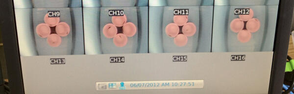
Video recording setup from a swimming behavior assay system
Behavioral Toxicology Laboratory — Columbia, Missouri. Screen shot of a computer monitor from a video recording setup from a swimming behavior experimental swimming behavior assay system. U.S. Geological Survey (USGS) scientists can record swimming activity of multiple treatments simultaneously in the swimming behavior assay.
Behavioral Toxicology Laboratory — Columbia, Missouri. Screen shot of a computer monitor from a video recording setup from a swimming behavior experimental swimming behavior assay system. U.S. Geological Survey (USGS) scientists can record swimming activity of multiple treatments simultaneously in the swimming behavior assay.