
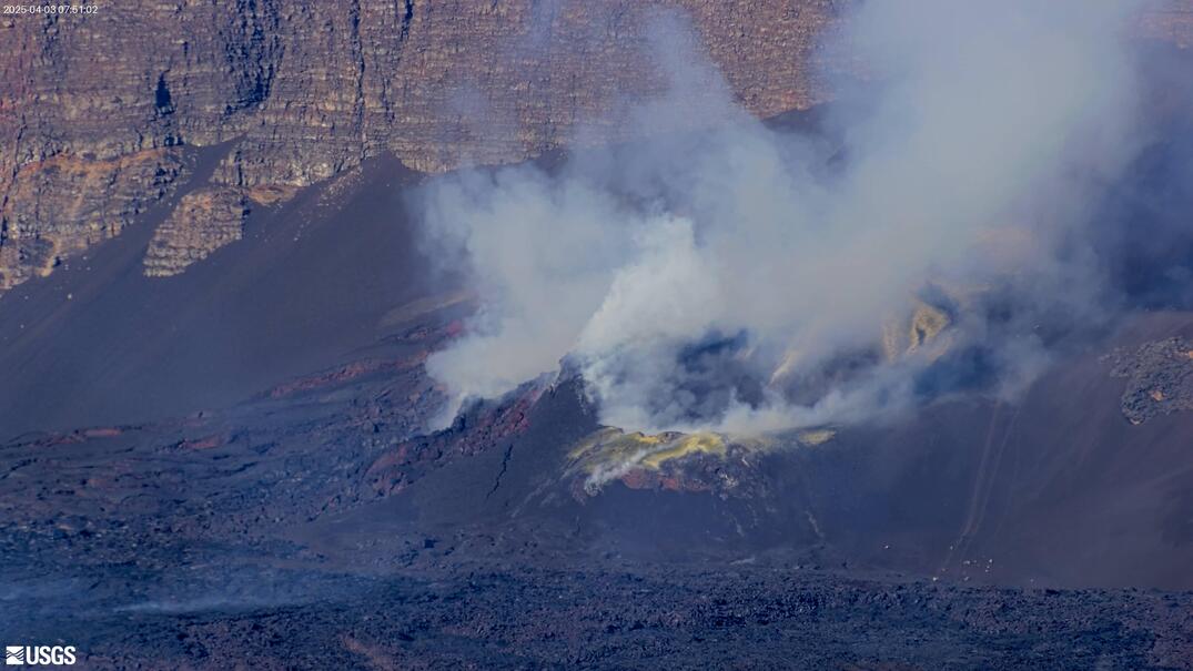
View of north and south vents from the northwest, approximately 21 hours after the end of episode 18 of the eruption at Kīlauea's summit. Volcanic gases, mostly water vapor, obscure most of the view as the wind blows the gas northwards. USGS photo by N. Deligne.
Multimedia
Images

April 23, 2025 — Steamy view of vents a day after episode 18 at Kīlauea's summit
View of north and south vents from the northwest, approximately 21 hours after the end of episode 18 of the eruption at Kīlauea's summit. Volcanic gases, mostly water vapor, obscure most of the view as the wind blows the gas northwards. USGS photo by N. Deligne.

April 23, 2025 — Tephra fall covering road near Uēkahuna at Kīlauea's summit
Episode 18 on April 22, 2025, of Kīlauea's ongoing eruption occurred during wind conditions that resulted in tephra being deposited in the Uēkahuna area, north of the vents. Hawai‘i Volcanoes National Park temporarily closed the Uēkahuna area at the time and cleaned affected roads and parking lots after episode 18 ended (foreground).
Episode 18 on April 22, 2025, of Kīlauea's ongoing eruption occurred during wind conditions that resulted in tephra being deposited in the Uēkahuna area, north of the vents. Hawai‘i Volcanoes National Park temporarily closed the Uēkahuna area at the time and cleaned affected roads and parking lots after episode 18 ended (foreground).

April 22, 2025 — Kīlauea summit eruption episode 18
This photo shows a close up of the south vent at the summit of Kīlauea during episode 18. USGS photo by M. Patrick.
This photo shows a close up of the south vent at the summit of Kīlauea during episode 18. USGS photo by M. Patrick.

April 22, 2025 — Kīlauea summit eruption episode 18
This photo shows a close up of the north vent at the summit of Kīlauea during episode 18 of the ongoing eruption. Low fountaining supplied lava to a lava pond that was continuously overflowing the rim of the cone, creating swiftly moving cascades of lava down the flank of the cone. USGS photo by M. Patrick.
This photo shows a close up of the north vent at the summit of Kīlauea during episode 18 of the ongoing eruption. Low fountaining supplied lava to a lava pond that was continuously overflowing the rim of the cone, creating swiftly moving cascades of lava down the flank of the cone. USGS photo by M. Patrick.

April 22, 2025 — Episode 18 lava fountaining at Kīlauea summit
Dawn timelapse image showing the shadow of the episode 18 lava fountain in Halemaʻumaʻu on the west caldera wall at the summit of Kīlauea. USGS photo by M. Patrick.
Dawn timelapse image showing the shadow of the episode 18 lava fountain in Halemaʻumaʻu on the west caldera wall at the summit of Kīlauea. USGS photo by M. Patrick.
April 20, 2025 — Intermittent eruptive activity at Kīlauea
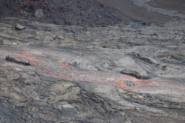
A closer view of the ephemeral lava channel active the morning of April 20, supplied by lava from the intermittent activity at the south vent at Kīlauea summit. USGS photo by M. Patrick.
A closer view of the ephemeral lava channel active the morning of April 20, supplied by lava from the intermittent activity at the south vent at Kīlauea summit. USGS photo by M. Patrick.
Videos

April 22, 2025 — Kīlauea Episode 18 Lava Fountaining Video
This video shows a clip from a USGS Hawaiian Volcano Observatory monitoring helicopter overflight on Tuesday, April 22, when high fountaining was occurring from the south vent at the summit of Kīlauea during episode 18 of the ongoing eruption. Other clips show activity captured during a field visit to the south rim of the caldera.
This video shows a clip from a USGS Hawaiian Volcano Observatory monitoring helicopter overflight on Tuesday, April 22, when high fountaining was occurring from the south vent at the summit of Kīlauea during episode 18 of the ongoing eruption. Other clips show activity captured during a field visit to the south rim of the caldera.

April 20, 2025 — Timelapse video of intermittent eruptive activity at Kīlauea
This timelapse video shows approximately 1 hour of activity compressed into 38 seconds, and covers a period of intermittent activity in the south vent the morning of April 20.
This timelapse video shows approximately 1 hour of activity compressed into 38 seconds, and covers a period of intermittent activity in the south vent the morning of April 20.

April 9, 2025 — VIews of episode 17 at Kīlauea summit, VIDEO
This video shows clips from a helicopter overflight and a field visit by USGS Hawaiian Volcano Observatory geologists to the crater rim to observe the lava fountaining in episode 17 of the ongoing summit eruption of Kīlauea.
This video shows clips from a helicopter overflight and a field visit by USGS Hawaiian Volcano Observatory geologists to the crater rim to observe the lava fountaining in episode 17 of the ongoing summit eruption of Kīlauea.

Timelapse video of episode 16 lava fountaining
This timelapse video shows lava fountaining during episode 16 of the ongoing summit eruption at Kīlauea. The fountain height rose rapidly during the onset and reached heights of about 300 meters (1000 feet). The fountain was relatively stable, but sometimes shows variations in inclination, presumably due to changes in vent geometry or wind direction.
This timelapse video shows lava fountaining during episode 16 of the ongoing summit eruption at Kīlauea. The fountain height rose rapidly during the onset and reached heights of about 300 meters (1000 feet). The fountain was relatively stable, but sometimes shows variations in inclination, presumably due to changes in vent geometry or wind direction.

April 1, 2025 — Kīlauea episode 16 lava fountain and flow VIDEO
Aerial video of Kīlauea summit eruption episode 16 lava fountain and its lava flow on April 1, 2025, taken during a USGS Hawaiian Volcano Observatory monitoring overflight at approximately noon. The lava fountain was reaching heights of more than 650 ft (200 m) at times and feeding a lava flow that as of noon on April 1 reached about 2,300 ft (700 m) from its vent.
Aerial video of Kīlauea summit eruption episode 16 lava fountain and its lava flow on April 1, 2025, taken during a USGS Hawaiian Volcano Observatory monitoring overflight at approximately noon. The lava fountain was reaching heights of more than 650 ft (200 m) at times and feeding a lava flow that as of noon on April 1 reached about 2,300 ft (700 m) from its vent.

March 29, 2025 — Timelapse video of episode 15 lava fountaining, Kīlauea
This timelapse video shows lava fountaining during episode 15 of the summit eruption at Kīlauea volcano. The sequence starts with small filling-draining cycles in the vent that abruptly shift into major fountaining. The inclination of the fountain changes repeatedly, depositing lava in varying directions around the vent.
This timelapse video shows lava fountaining during episode 15 of the summit eruption at Kīlauea volcano. The sequence starts with small filling-draining cycles in the vent that abruptly shift into major fountaining. The inclination of the fountain changes repeatedly, depositing lava in varying directions around the vent.
Audio

Lava lake activity from inside Halema`uma`u Crater
Sounds of lava lake activity within Kilauea Volcano's summit vent inside Halema`uma`u Crater on the afternoon of February 14, 2011. The continuous "crashing wave" noise is the sound of churning lava as gases are released from the lake surface, which is in nearly constant motion.
Sounds of lava lake activity within Kilauea Volcano's summit vent inside Halema`uma`u Crater on the afternoon of February 14, 2011. The continuous "crashing wave" noise is the sound of churning lava as gases are released from the lake surface, which is in nearly constant motion.

Dramatic Developments at Kilauea Volcano
Kilauea Volcano in Hawaii has experienced its first explosive eruption in more than 80 years and is now spewing noxious gas at 10 times the normal rate. John Eichelberger, head of the USGS Volcano Hazards Program, fills us in on the situation.
Kilauea Volcano in Hawaii has experienced its first explosive eruption in more than 80 years and is now spewing noxious gas at 10 times the normal rate. John Eichelberger, head of the USGS Volcano Hazards Program, fills us in on the situation.
Webcams
[V2cam] Kīlauea volcano, Hawaii (east Halemaʻumaʻu crater)
Live view of Kaluapele (Kīlauea caldera) and Halemaʻumaʻu crater, from the northeast rim of the caldera [V2cam]. This camera is a pan-tilt-zoom model and the view may change depending on activity.
Disclaimer
Live view of Kaluapele (Kīlauea caldera) and Halemaʻumaʻu crater, from the northeast rim of the caldera [V2cam]. This camera is a pan-tilt-zoom model and the view may change depending on activity.
Disclaimer
[S2cam] - View of Halemaʻumaʻu crater at the summit of Kīlauea, view is to the west
Live view of Halemaʻumaʻu crater at the summit of Kīlauea; camera is positioned on the south rim and the view is to the west [S2cam].
Disclaimer
Live view of Halemaʻumaʻu crater at the summit of Kīlauea; camera is positioned on the south rim and the view is to the west [S2cam].
Disclaimer

[KOcam] Live Image of upper East Rift Zone from Maunaulu
This image is from a temporary research camera positioned near Maunaulu, looking northwest toward the upper East Rift Zone of Kīlauea.
Disclaimer
This image is from a temporary research camera positioned near Maunaulu, looking northwest toward the upper East Rift Zone of Kīlauea.
Disclaimer
[MITDcam] Kīlauea upper Southwest Rift Zone
[MITDcam] Live view of Kīlauea's upper Southwest Rift Zone, looking northwest from a seismic station in the Kaʻū Desert.
[MITDcam] Live view of Kīlauea's upper Southwest Rift Zone, looking northwest from a seismic station in the Kaʻū Desert.
Kīlauea Volcano Live Stream - Halemaʻumaʻu crater
Live view of the eruption in Halemaʻumaʻu, from the northwest rim of the caldera, looking east [V1cam] on the USGS YouTube Channel.
Live view of the eruption in Halemaʻumaʻu, from the northwest rim of the caldera, looking east [V1cam] on the USGS YouTube Channel.

[V1cam] Kīlauea volcano, Hawaii (west Halemaʻumaʻu crater)
Live view of Halemaʻumaʻu crater within Kaluapele (Kīlauea caldera), from the northwest rim of the crater [V1cam]. This camera is a pan-tilt-zoom model and the view may change depending on activity.
Disclaimer
Live view of Halemaʻumaʻu crater within Kaluapele (Kīlauea caldera), from the northwest rim of the crater [V1cam]. This camera is a pan-tilt-zoom model and the view may change depending on activity.
Disclaimer