
A USGS Hawaiian Volcano Observatory geologist collects high-precision ground positions using a kinematic GPS instrument that measures its vertical and horizontal position. Once processed, these measurements will help scientists determine the thickness of the tephra deposit downwind of the ongoing Halema‘uma‘u eruption at Kīlauea summit.
Images
Kīlauea images of eruptive activity, field work, and more.
Filter Total Items: 2688

May 29, 2025 — Kīlauea summit fieldwork after episode 23
A USGS Hawaiian Volcano Observatory geologist collects high-precision ground positions using a kinematic GPS instrument that measures its vertical and horizontal position. Once processed, these measurements will help scientists determine the thickness of the tephra deposit downwind of the ongoing Halema‘uma‘u eruption at Kīlauea summit.

May 29, 2025 — Kīlauea summit fieldwork after episode 23
A thick deposit of tephra from the high fountaining of episode 23—along with accumulation from previous episodes—of the ongoing Kīlauea summit eruption, blankets the southwestern rim of Halema‘uma‘u crater. The deposit, within the closed area of Hawai‘i Volcanoes National Park, underscores the hazardous nature of this area.
A thick deposit of tephra from the high fountaining of episode 23—along with accumulation from previous episodes—of the ongoing Kīlauea summit eruption, blankets the southwestern rim of Halema‘uma‘u crater. The deposit, within the closed area of Hawai‘i Volcanoes National Park, underscores the hazardous nature of this area.

May 29, 2025 — Kīlauea summit fieldwork after episode 23
A view from the south rim of Halema‘uma‘u crater looking at the active vents. The ongoing Kīlauea summit eruption that began on December 23, 2024, is currently paused following the high fountaining of episode 23 on Sunday, May 25.
A view from the south rim of Halema‘uma‘u crater looking at the active vents. The ongoing Kīlauea summit eruption that began on December 23, 2024, is currently paused following the high fountaining of episode 23 on Sunday, May 25.

May 29, 2025 — Kīlauea thermal maps following episode 21 and 23
This compilation shows thermal maps of Kīlauea summit collected on May 14 and 28, 2025. These maps followed episodes 21 and 23 of the ongoing Kīlauea summit eruption, respectively, and both show inactive but warm lava flows produced by the preceding lava fountaining episodes.
This compilation shows thermal maps of Kīlauea summit collected on May 14 and 28, 2025. These maps followed episodes 21 and 23 of the ongoing Kīlauea summit eruption, respectively, and both show inactive but warm lava flows produced by the preceding lava fountaining episodes.

May 28, 2025 — View of southwest Halema‘uma‘u at Kīlauea volcano
This view of the southwest portion of Halema‘uma‘u (top right of photo) was captured during a USGS Hawaiian Volcano Observatory monitoring helicopter overflight on Wednesday, May 28, 2025. Part of Crater Rim Drive in Hawai‘i Volcanoes National Park, which has been closed to the public since 2007, is visible in the center of the photo.
This view of the southwest portion of Halema‘uma‘u (top right of photo) was captured during a USGS Hawaiian Volcano Observatory monitoring helicopter overflight on Wednesday, May 28, 2025. Part of Crater Rim Drive in Hawai‘i Volcanoes National Park, which has been closed to the public since 2007, is visible in the center of the photo.

May 25, 2025 — Two lava fountains at the summit of Kīlauea
Both the north and south vents in Halemaʻumaʻu erupted during episode 23 on May 23, as shown in this V3 webcam image taken at 5:25 p.m. HST. USGS webcam image.
Both the north and south vents in Halemaʻumaʻu erupted during episode 23 on May 23, as shown in this V3 webcam image taken at 5:25 p.m. HST. USGS webcam image.

May 25, 2025 — Kīlauea Episode 23
Episode 23 lava fountaining at Kīlauea summit began around 4:30 p.m. HST on May 25. The episode was active into the evening, and this view shows the eruption at around sunset. USGS photo by M. Patrick.
Episode 23 lava fountaining at Kīlauea summit began around 4:30 p.m. HST on May 25. The episode was active into the evening, and this view shows the eruption at around sunset. USGS photo by M. Patrick.

May 25, 2025 — Lava flows during episode 23 at Kīlauea summit
The lava fountaining at the summit of Kīlauea during episode 23 on May 25 produced lava flows that rapidly covered portions of the western parts of Halemaʻumaʻu floor. Eventually, lava flows reached into the eastern portion of crater before the episode ended at 10:25 p.m. HST on May 25. USGS photo by M. Patrick.
The lava fountaining at the summit of Kīlauea during episode 23 on May 25 produced lava flows that rapidly covered portions of the western parts of Halemaʻumaʻu floor. Eventually, lava flows reached into the eastern portion of crater before the episode ended at 10:25 p.m. HST on May 25. USGS photo by M. Patrick.

May 25, 2025 — Kīlauea Episode 23
Another view of the complex lava fountaining geometry during episode 23 at the summit of Kīlauea on May 25. The tall and low fountains on the right originate from the south vent, while the wider fountain on the left comes from the north vent, whose cone rim is visible at the bottom of the photo. USGS photo by M. Patrick.
Another view of the complex lava fountaining geometry during episode 23 at the summit of Kīlauea on May 25. The tall and low fountains on the right originate from the south vent, while the wider fountain on the left comes from the north vent, whose cone rim is visible at the bottom of the photo. USGS photo by M. Patrick.
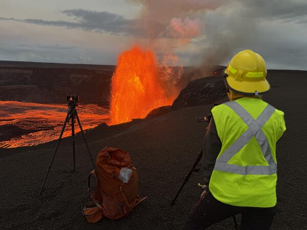
May 25, 2025 — Monitoring Episode 23 at the Summit of Kīlauea
USGS Hawaiian Volcano Observatory geologists observe the episode 23 lava fountaining at the summit of Kīlauea from the western caldera rim on May 25. USGS photo by M. Patrick.
USGS Hawaiian Volcano Observatory geologists observe the episode 23 lava fountaining at the summit of Kīlauea from the western caldera rim on May 25. USGS photo by M. Patrick.

May 25, 2025 — Kīlauea Episode 23 Lava Fountain Top
A view of the top of the north fountain (left) and the south fountain (right) during episode 23 at the summit of Kīlauea, showing the variable colors (and temperatures) of clasts forming the fountain. USGS photo by M. Patrick.
A view of the top of the north fountain (left) and the south fountain (right) during episode 23 at the summit of Kīlauea, showing the variable colors (and temperatures) of clasts forming the fountain. USGS photo by M. Patrick.

May 25, 2025 — Kīlauea Episode 23 North Vent
Another telephoto view of the base of the north lava fountain, with the south fountain behind it to the right. Both the north and the south vents were active during episode 23 lava fountaining at the summit of Kīlauea on May 25. USGS photo by M. Patrick.
Another telephoto view of the base of the north lava fountain, with the south fountain behind it to the right. Both the north and the south vents were active during episode 23 lava fountaining at the summit of Kīlauea on May 25. USGS photo by M. Patrick.

May 25, 2025 — Kīlauea Episode 23
Episode 23 at the summit of Kīlauea included lava fountaining from both the south and north vents. The tall narrow finger of lava shown here, as well as the lower fountaining to the right, are both sourced from the south vent, while the wider fountain originates from the north vent. USGS photo by M. Patrick.
Episode 23 at the summit of Kīlauea included lava fountaining from both the south and north vents. The tall narrow finger of lava shown here, as well as the lower fountaining to the right, are both sourced from the south vent, while the wider fountain originates from the north vent. USGS photo by M. Patrick.

Kīlauea spectrogram before episode 20
This spectrogram shows four hours of USGS Hawaiian Volcano Observatory data streams across six seismic stations at Kīlauea’s summit on May 6, 2025. Each panel is 10 minutes of data. Over the four-hour period, an earthquake, pulsing, and eruptive tremor are visible.
This spectrogram shows four hours of USGS Hawaiian Volcano Observatory data streams across six seismic stations at Kīlauea’s summit on May 6, 2025. Each panel is 10 minutes of data. Over the four-hour period, an earthquake, pulsing, and eruptive tremor are visible.

May 22, 2025 — FTIR at Kīlauea summit
A USGS Hawaiian Volcano Observatory geologist uses an FTIR (Fourier transform infrared spectrometer) to measure the chemical composition of volcanic gas during cycles of spattering and seismic tremor at the active vent at Kīlauea summit on May 22, 2025. USGS photo by M. Patrick.
A USGS Hawaiian Volcano Observatory geologist uses an FTIR (Fourier transform infrared spectrometer) to measure the chemical composition of volcanic gas during cycles of spattering and seismic tremor at the active vent at Kīlauea summit on May 22, 2025. USGS photo by M. Patrick.

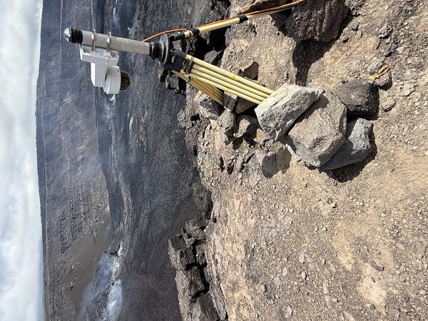
May 22, 2025 — Kīlauea summit V3cam
A view of the V3cam site located on the south rim of Halemaʻumaʻu crater and Kaluapele. The camera, which was installed with permission from Hawaiʻi Volcanoes National Park, is one of three that provide livestream views of the ongoing episodic eruption at the summit of Kīlauea. USGS photo by M. Warren.
A view of the V3cam site located on the south rim of Halemaʻumaʻu crater and Kaluapele. The camera, which was installed with permission from Hawaiʻi Volcanoes National Park, is one of three that provide livestream views of the ongoing episodic eruption at the summit of Kīlauea. USGS photo by M. Warren.
May 22, 2025 — Kīlauea V3cam
This photograph shows the new V3cam, installed by the USGS Hawaiian Volcano Observatory (HVO) in mid-May 2025. The V3cam, like all of the HVO monitoring cameras that start with "V," is a pan-tilt-zoom model that can be controlled remotely. This capability is useful in evaluating the ongoing episodic eruptive activity within Halemaʻumaʻu, and the associated hazards.
This photograph shows the new V3cam, installed by the USGS Hawaiian Volcano Observatory (HVO) in mid-May 2025. The V3cam, like all of the HVO monitoring cameras that start with "V," is a pan-tilt-zoom model that can be controlled remotely. This capability is useful in evaluating the ongoing episodic eruptive activity within Halemaʻumaʻu, and the associated hazards.

May 22, 2025 — Adjusting V3cam at the summit of Kīlauea
On May 22, 2025, USGS Hawaiian Volcano Observatory (HVO) staff stabilized the new V3cam livestream camera. The camera was installed just last week and views since then were shaky due to the strong winds which are common in the caldera. The camera was moved from a tall mast to a more stable tripod setup.
On May 22, 2025, USGS Hawaiian Volcano Observatory (HVO) staff stabilized the new V3cam livestream camera. The camera was installed just last week and views since then were shaky due to the strong winds which are common in the caldera. The camera was moved from a tall mast to a more stable tripod setup.
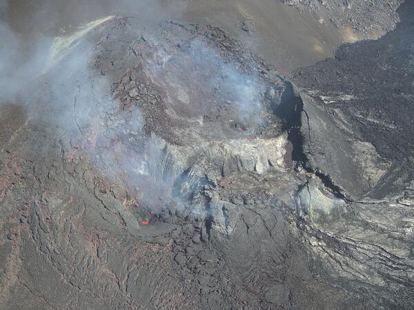
May 21, 2025 — UAS overview of eruptive vents
On May 21, USGS Hawaiian Volcano Observatory geologists flew UAS (uncrewed aircraft systems) into Halemaʻumaʻu to monitor the ongoing Kīlauea summit eruption. This oblique aerial photo provides an overview of the two eruptive vents, north (back) and south (front).
On May 21, USGS Hawaiian Volcano Observatory geologists flew UAS (uncrewed aircraft systems) into Halemaʻumaʻu to monitor the ongoing Kīlauea summit eruption. This oblique aerial photo provides an overview of the two eruptive vents, north (back) and south (front).

May 21, 2025 — UAS view of north vent
During UAS (uncrewed aircraft systems) overflights on May 21, the north vent within Halemaʻumaʻu at the summit of Kīlauea was occasionally spattering and consistently glowing with incandescence.
During UAS (uncrewed aircraft systems) overflights on May 21, the north vent within Halemaʻumaʻu at the summit of Kīlauea was occasionally spattering and consistently glowing with incandescence.

May 21, 2025 — UAS close-up of south vent lava pond
During UAS (uncrewed aircraft systems) overflights on May 21, USGS Hawaiian Volcano Observatory geologists flew their aircraft directly above the south vent within Halemaʻumaʻu at the summit of Kīlauea.
During UAS (uncrewed aircraft systems) overflights on May 21, USGS Hawaiian Volcano Observatory geologists flew their aircraft directly above the south vent within Halemaʻumaʻu at the summit of Kīlauea.