
Landsat 101
So what is Landsat?
Well, at the most basic level, each Landsat is a satellite equipped with sensors that record the light reflected by the land. Those measurements of light can be transformed into images. You can think of the name as short for “Land Satellite."
This recording of light energy from above is a form of “remote sensing.” Simply put, remote sensing means “observing from a distance.” The sensors onboard Landsat satellites use reflected light to detect electromagnetic energy on the Earth’s surface—energy represented by the electromagnetic spectrum, both visible and invisible.
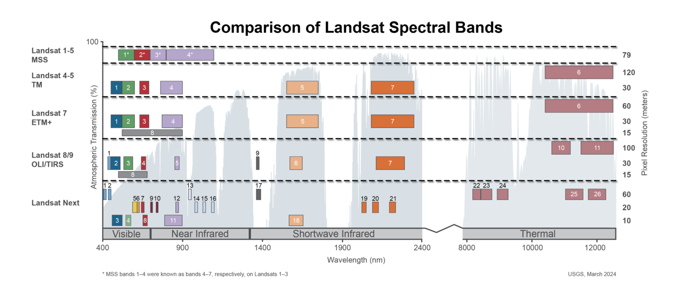
The light from the Sun that we can see is only a small part of the spectrum, and includes the colors of the rainbow. Landsat’s sensors record this information in different portions of the electromagnetic spectrum, which is measured in wavelengths. Landsat satellite sensors detect both visible and infrared light.
The chart below should give you an idea of what that looks like. Visible light (red, green, blue) lives in the neighborhood of 380-700 nanometers, on the left-hand side of the chart. The acronyms stand for different sensors onboard different Landsat satellites; the numbers represent the "bands" of the spectrum gathered by those respective sensors. You can learn more about those on this FAQ page.
Landsat satellites fly 438 miles above the Earth’s surface, an altitude known as “low-Earth orbit.” They complete one orbit every 99 minutes, for 14 ½ orbits per day. This means it takes 16 days for each satellite to obtain imagery over the entire globe, with imagery collected in 115-mile wide swaths.
Together, the two operational satellites on orbit today—Landsat 8 and Landsat 9—image Earth's landmasses every 8 days.
Now that you have the basics, we can explore a bit more, through some of the educational tools on offer from the USGS Earth Resources Observation and Science (EROS) Center, where Landsat data is processed, archived, and distributed to users the world over.
The USGS library of educational resources opens the door to Landsat and remote sensing, and to how scientists at the USGS EROS Center and around the world use the data to study landscape changes.
Lessons, games, and real-world examples show how Landsat is applied to monitor both human-caused and natural changes. Here are a few highlights:
Earthshots

Earthshots is perfect for teachers or anyone who wants to know how remote sensing is used to study our changing world. But you don’t need to be a remote sensing expert to explore these aerial photos and satellite data. This living, frequently updated website offers plain language descriptions and slideshows of landscape change.
All the imagery comes from the massive USGS EROS archive.
Each Earthshots page features a different location from around the world and explains the changes that the images reveal. Easy-to-navigate categories like Agriculture, Cities, Mining, and much more put stories on these topics of land change at your fingertips. Besides that, the site features an interactive, spinnable globe so you can browse the world for these stories of environmental change.
Follow this link to visit Earthshots!
Remote Sensing Classroom
Fun and engaging lessons allow students to look at satellite imagery and perform remote sensing analysis. The Land Change with Landsat lessons first introduce you to how Landsat works and then take a deep dive into types of land change, such as urban growth and glaciers. You can test your skills with a few games and puzzles, too.
Follow this link to access the remote sensing classroom!
Landsat State Mosaics

Download your own satellite images of all 50 states! These Landsat mosaics were created with cloud-free, high-resolution data, suitable for everything from desktop wallpaper to full-sized posters.
Our easy-to-use interactive website also includes brief information about the state, links to the Landsat online state puzzles, and even the number of Landsat pixels it took to build the mosaic. It’s easy to download a JPG or TIF file of your favorite state.
Click here to find your state!
Landsat Story Maps
Powell 150
John Wesley Powell led an epic expedition down the Green and Colorado Rivers in 1869. The team left Green River, Wyoming, on May 24, 1869, and made it past the Grand Canyon to the confluence of the Colorado River and the Virgin River on August 30. Our story map commemorating the 150th anniversary of the trek details the adventures of Powell and his team as seen from modern satellite images.
Click here to follow the trail through Landsat imagery.

Landsat 9 Road to Launch
Landsat 9 launched into space from Vandenberg Space Force Base on September 28, 2021 to carry on the 50-year legacy of a program that revolutionized the world of remote sensing. The journey from concept to reality for the ninth iteration of Landsat was years in the making. This geonarrative walks through the highlights and milestones along the way.
Click here to explore the Landsat 9 Road to Launch.
Landsat Virtual Booth
Want to work your way through Landsat's history and legacy in an interactive fashion? Landsat's virtual booth is the place to visit. This storymap has sections on Landsat history, data access, educational resource links, and links to the latest news.
Click here to explore the Virtual Booth.
Landsat Satellites
Each Landsat mission marked scientific milestones for the program. The Landsat Missions Team has compiled a story map highlighting the accomplishments of each operational mission.
Follow this link to access Landsat Satellites.