
Description of the Pecora Award. This image details the procedure for nominations, eligibility, and privacy statement.
Images
Explore USGS Landsat Program images.
Filter Total Items: 301

Flyer 2 Pecora 2022 Award Call for Nominations
Description of the Pecora Award. This image details the procedure for nominations, eligibility, and privacy statement.

Fire near Uljin-eup, South Korea (Natural Color)
Landsat 9 captured this natural color image of the ongoing fire in Uljin county on South Korea’s west coast.
Landsat 9 captured this natural color image of the ongoing fire in Uljin county on South Korea’s west coast.

Fire near Uljin-eup, South Korea (False Color)
Landsat 9 captured an image of the ongoing fire in Uljin county on South Korea’s west coast. The false color image looks beneath the smoke and shows the burn scar as reddish-brown and the heat signature from the fire as bright red.
Landsat 9 captured an image of the ongoing fire in Uljin county on South Korea’s west coast. The false color image looks beneath the smoke and shows the burn scar as reddish-brown and the heat signature from the fire as bright red.
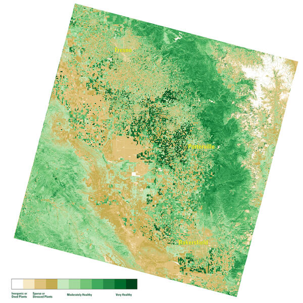
NDVI map of the San Joaquin Valley Region, March 10, 2022
A Landsat Surface Reflectance (SR) Normalized Difference Index (NDVI) map of the San Joaquin Valley region of California on March 10, 2022.
A Landsat Surface Reflectance (SR) Normalized Difference Index (NDVI) map of the San Joaquin Valley region of California on March 10, 2022.
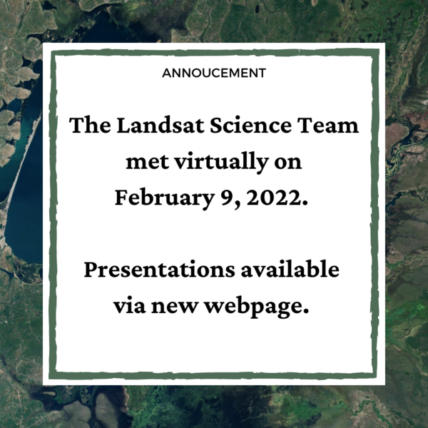
Landsat Science Team Meeting Presentations Available
The Landsat Science Team met virtually on February 9, 2022. Topics included, but were not limited to, Landsat 9 operations, calibration, and data release plans; Landsat 7 mission status; Landsat and Sentinel harmonization; and the future of land imaging.
The Landsat Science Team met virtually on February 9, 2022. Topics included, but were not limited to, Landsat 9 operations, calibration, and data release plans; Landsat 7 mission status; Landsat and Sentinel harmonization; and the future of land imaging.

Using Satellite-derived Maps in Rangeland Management
Rangeland management has used Landsat imagery for 50 years. Satellite imagery can provide a more comprehensive view of native pastures and prairies that cover swaths of Western America.
A new paper in Elsevier provides four guiding principles for ranges:
1. Use maps within a decision-making framework

Landsat 9 image of Bangladesh Coast
Landsat 9 natural color image (Bands 4, 3, 2) of the Bangladesh coastline on the Bay of Bengal acquired on February 8, 2022. The Sundarbans mangrove forest, a protected UNESCO area, appears as dark green on the left side of the image. The right side of the image shows agricultural lands and urban areas as light tan and gray.
Landsat 9 natural color image (Bands 4, 3, 2) of the Bangladesh coastline on the Bay of Bengal acquired on February 8, 2022. The Sundarbans mangrove forest, a protected UNESCO area, appears as dark green on the left side of the image. The right side of the image shows agricultural lands and urban areas as light tan and gray.

Landsat 9 image of St. Petersburg and Tampa, Florida area
False color image of Landsat 9 image of the St. Petersburg and Tampa, Florida area as seen by Landsat 9 on January 30, 2022. Between Landsat 8 and Landsat 9, the Landsat program delivers complete coverage of the Earth’s surface every eight days.
Landsat Scene ID LC09_L1TP_017041_20220130_20220130_02_T1

Landsat 9 image of San Francisco Bay, California
This natural color Landsat 9 image from December 10, 2021 shows the cities of San Francisco, San Jose, and Oakland surrounding the San Francisco Bay. The bay is the largest estuary on the west coast and includes a patchwork of mud flats, salt marshes, and salt ponds.
This natural color Landsat 9 image from December 10, 2021 shows the cities of San Francisco, San Jose, and Oakland surrounding the San Francisco Bay. The bay is the largest estuary on the west coast and includes a patchwork of mud flats, salt marshes, and salt ponds.

Pecora Abstract & Special Session Deadline Extended
The deadline for Special Sessions and Abstracts has been extended to March 15, 2022.
The deadline for Special Sessions and Abstracts has been extended to March 15, 2022.

How Do You Landsat with Chinese Forests.png
Landscape ecologists are increasingly researching change processes with regards to spatial patterns.
Landscape ecologists are increasingly researching change processes with regards to spatial patterns.

Landsat 9 Image of Western Guinea-Bissau
The Geba River on the west coast of Guinea-Bissau is seen in this natural color Landsat 9 image from February 8, 2022. Silt carried by the river into the Atlantic Ocean creates intricate patterns as it moves around the Bissagos (or Bijagós) Islands. The country’s capital, Bissau, can be seen on the north side of the estuary and appears as light brown.
The Geba River on the west coast of Guinea-Bissau is seen in this natural color Landsat 9 image from February 8, 2022. Silt carried by the river into the Atlantic Ocean creates intricate patterns as it moves around the Bissagos (or Bijagós) Islands. The country’s capital, Bissau, can be seen on the north side of the estuary and appears as light brown.

Landsat Collection 2 Fractional Snow Covered Area (fSCA) Grid Map
This map shows where Landsat Collection 2 fractional Snow Covered Area (fSCA) and Canopy Adjusted fSCA data is available for the conterminous United States (top) and Alaska (below). To learn more visit the Landsat Collection 2 fSCA science products web page.
This map shows where Landsat Collection 2 fractional Snow Covered Area (fSCA) and Canopy Adjusted fSCA data is available for the conterminous United States (top) and Alaska (below). To learn more visit the Landsat Collection 2 fSCA science products web page.

Landsat 9 image of Abaco Island, The Bahamas
Natural color image of Abacco Islands, the Bahamas, as seen by Landsat 9 on January 18, 2022. Between Landsat 8 and Landsat 9, the Landsat program delivers complete coverage of the Earth’s surface every eight days.
Landsat Scene ID LC09_L1TP_013042_20220118_20220118_02_T1
Natural color image of Abacco Islands, the Bahamas, as seen by Landsat 9 on January 18, 2022. Between Landsat 8 and Landsat 9, the Landsat program delivers complete coverage of the Earth’s surface every eight days.
Landsat Scene ID LC09_L1TP_013042_20220118_20220118_02_T1

How Do You Landsat in the Brazil Cerrado
The South American Savannas host several species, including ocelots and nutria rats. The soil is rich soil results in plantations of bananas, coffee, and other crops. Areas are cleared out for the fertile humus. The tropical Brazilian Cerrado is the largest savanna on the continent and the most threated biome from agricultural expansion.
The South American Savannas host several species, including ocelots and nutria rats. The soil is rich soil results in plantations of bananas, coffee, and other crops. Areas are cleared out for the fertile humus. The tropical Brazilian Cerrado is the largest savanna on the continent and the most threated biome from agricultural expansion.

Latest for Landsat
Landsat Updates are prepared periodically and distributed electronically to provide information about Landsat activities and related topics of interest.
Read more here: https://www.usgs.gov/landsat-missions/news/landsat-update-special-issue…
Landsat Updates are prepared periodically and distributed electronically to provide information about Landsat activities and related topics of interest.
Read more here: https://www.usgs.gov/landsat-missions/news/landsat-update-special-issue…


LIMA Image
In the International Polar Year 2007-2008, Landsat 7 brought the coldest continent to life with high resolution satellite imagery.
In the International Polar Year 2007-2008, Landsat 7 brought the coldest continent to life with high resolution satellite imagery.

How Do You Landsat from a Delta in China
With rapidly rising sea levels and drastically declining river discharge, the Changjiang Delta, near Shanghai, China, is continually evolving. Using Landsat imagery, researchers focused on tidal level fluctuations to help understand the changes to the largest uninhabited island in the estuary, Jiuduansha island.
With rapidly rising sea levels and drastically declining river discharge, the Changjiang Delta, near Shanghai, China, is continually evolving. Using Landsat imagery, researchers focused on tidal level fluctuations to help understand the changes to the largest uninhabited island in the estuary, Jiuduansha island.

Landsat 8 Image of Lake Tahoe
The Operational Land Imager (OLI) onboard Landsat 8 captured this image of Lake Tahoe.
The Operational Land Imager (OLI) onboard Landsat 8 captured this image of Lake Tahoe.

The Svalbard (SGS) Ground Station for the Landsat Program
The Svalbard (SGS) ground station is located at the SvalSat facility in Svalbard, Norway. SGS supports both the Landsat 8 and Landsat 9 missions.
The Svalbard (SGS) ground station is located at the SvalSat facility in Svalbard, Norway. SGS supports both the Landsat 8 and Landsat 9 missions.