
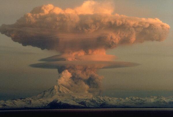
Ascending eruption cloud from Redoubt Volcano as viewed to the west from the Kenai Peninsula. The mushroom-shaped plume rose from avalanches of hot debris (pyroclastic flows) that cascaded down the north flank of the volcano. A smaller, white steam plume rises from the summit crater.
Images
Images intro.
Filter Total Items: 7146
Redoubt Volcano
Ascending eruption cloud from Redoubt Volcano as viewed to the west from the Kenai Peninsula. The mushroom-shaped plume rose from avalanches of hot debris (pyroclastic flows) that cascaded down the north flank of the volcano. A smaller, white steam plume rises from the summit crater.

Lava flow encroaching on Kalapana Gardens subdivision, Kīlauea
Aerial view of pāhoehoe flow encroaching on the Kalapana community. Hakuma horst, a raised fault block, is on the left. To the right of the point are fishponds, and to their right, Walter's Kalapana Store and Drive Inn. In the large trapezoidal plot are Mauna Kea Congregational Church and hall.
Aerial view of pāhoehoe flow encroaching on the Kalapana community. Hakuma horst, a raised fault block, is on the left. To the right of the point are fishponds, and to their right, Walter's Kalapana Store and Drive Inn. In the large trapezoidal plot are Mauna Kea Congregational Church and hall.

Dusting of Redoubt Volcano ash on snow, Indian, AK, Feb. 21, 1990.
Dusting of Redoubt Volcano ash on snow, Indian, Alaska, February 21, 1990.
Dusting of Redoubt Volcano ash on snow, Indian, Alaska, February 21, 1990.

Channelized pāhoehoe flows from Kupaianaha vent, Kīlauea, Hawai‘i
View looking uphill at surface flows advancing down a steep slope (Pulama pali) between the east rift zone and the coastal plain of Kīlauea Volcano. Overflows from the channel on the right are building levees of pāhoehoe. Within a few days, crust accreting inward from the levees built a roof over the channel, forming a new lava tube.
View looking uphill at surface flows advancing down a steep slope (Pulama pali) between the east rift zone and the coastal plain of Kīlauea Volcano. Overflows from the channel on the right are building levees of pāhoehoe. Within a few days, crust accreting inward from the levees built a roof over the channel, forming a new lava tube.

Loma Prieta earthquake, Marina District
An automobile lies crushed under the third story of this apartment building in the Marina District. The ground levels are no longer visible because of structural failure and sinking due to liquefaction.
An automobile lies crushed under the third story of this apartment building in the Marina District. The ground levels are no longer visible because of structural failure and sinking due to liquefaction.

Ash deposits inside the jet engine that encountered the ash cloud f...
Top: Dark glassy deposits of melted volcanic ash on leading edge of highâ€pressure turbine nozzle guide vanes. Bottom: Accumulation of unmelted volcanic ash in the high-pressure turbine rotor.
Top: Dark glassy deposits of melted volcanic ash on leading edge of highâ€pressure turbine nozzle guide vanes. Bottom: Accumulation of unmelted volcanic ash in the high-pressure turbine rotor.

Lava tube sea entry on Hawai'i Island
Lava flows from a lava tube into the sea near Kupapau Point on Hawai'i Island. From the Kilauea East Rift Zone (ERZ) eruption, November 27, 1989. Episode 48 of the Kupapau Lava Flow.
Lava flows from a lava tube into the sea near Kupapau Point on Hawai'i Island. From the Kilauea East Rift Zone (ERZ) eruption, November 27, 1989. Episode 48 of the Kupapau Lava Flow.

Kilauea lava flows from a tube into the sea, November 27, 1989
Lava flows from a lava tube into the sea near Kupapau Point on 11/27/1989. From the Kilauea East Rift Zone (ERZ) eruption, eruption pisode 48, Kupapau lava flow. Hawai'i Island.
Lava flows from a lava tube into the sea near Kupapau Point on 11/27/1989. From the Kilauea East Rift Zone (ERZ) eruption, eruption pisode 48, Kupapau lava flow. Hawai'i Island.

Damaged Building
A downtown building at the corner of Alice and 13th Streets lost part of its unreinforced facade and brick masonry.
A downtown building at the corner of Alice and 13th Streets lost part of its unreinforced facade and brick masonry.

Pahoehoe from Kilauea eruption, 1989
Pahoehoe ropes form in the Wahaula Lava Flow across from Wahaula Visitor Center on Hawai'i Island during the Kilauea East Rift Zone (ERZ) eruption on 6/15/89.
Pahoehoe ropes form in the Wahaula Lava Flow across from Wahaula Visitor Center on Hawai'i Island during the Kilauea East Rift Zone (ERZ) eruption on 6/15/89.

Angle and distance measurements to Mount St. Helens' flanks were ta...
Angle and distance measurements to the Mount St. Helens' flanks were taken periodically to monitor for deformation similar to the 1980 bulge. Station northeast of volcano.
Angle and distance measurements to the Mount St. Helens' flanks were taken periodically to monitor for deformation similar to the 1980 bulge. Station northeast of volcano.

Sediment retention dam on the North Fork Toutle River is designed t...
Sediment retention dam on the North Fork Toutle River is designed to help stop downstream movement of sediment near where it begins on Mount St. Helens' debris avalanche deposit.
Sediment retention dam on the North Fork Toutle River is designed to help stop downstream movement of sediment near where it begins on Mount St. Helens' debris avalanche deposit.

Mount Rainier seen from Puyallup, Washington

Carbon dioxide gas can collect in low-lying volcanic areas, posing ...
Fumaroles of cold, dry CO2 such as this one on a lava flow erupted in 1938 from Nyamuragira Volcano, Zaire, can be exceptionally dangerous because the gas discharge is invisible. The density difference between CO2 and air is so great that a sharp boundary can persist between them.
Fumaroles of cold, dry CO2 such as this one on a lava flow erupted in 1938 from Nyamuragira Volcano, Zaire, can be exceptionally dangerous because the gas discharge is invisible. The density difference between CO2 and air is so great that a sharp boundary can persist between them.

Giant Hawaiian Underwater Landslides
Large-scale poster describing USGS work.
The USGS, in cooperation with the UK Institute of Oceanographic Sciences (IOS) and others, took images of the seafloor 200 miles around the Hawaiian Islands using GLORIA. GLORIA is a long-range sonar that gives a bird’s-eye view of the seafloor.
Large-scale poster describing USGS work.
The USGS, in cooperation with the UK Institute of Oceanographic Sciences (IOS) and others, took images of the seafloor 200 miles around the Hawaiian Islands using GLORIA. GLORIA is a long-range sonar that gives a bird’s-eye view of the seafloor.

Lava bubble burst explosion, Kīlauea, Hawai‘i
A thin-walled lava bubble expands and bursts. These "bubble bursts" occur when seawater infiltrates the lava tube system near the shore. Such bubble bursts produce translucent sheets of spatter, or limu o Pele.
A thin-walled lava bubble expands and bursts. These "bubble bursts" occur when seawater infiltrates the lava tube system near the shore. Such bubble bursts produce translucent sheets of spatter, or limu o Pele.
Glacial end moraine deposits on south flank of Mauna Kea, Hawai‘i
Glacial end moraine deposits on south flank of Mauna Kea, Hawai‘i
Glacial end moraine deposits on south flank of Mauna Kea, Hawai‘i

Pu‘umaKAHAKOkanaka, NE flank of Mauna Kea, Hawai‘i
12,398 ft elev according to USGS Geographic Names Information System
12,398 ft elev according to USGS Geographic Names Information System

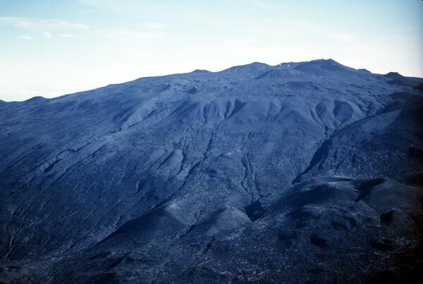
Upper south flank of Mauna Kea, Hawai‘i. Prominent cinder cone (low...
Pu‘u Keonehehe‘e and the two small cones immediately to the northwest (left) are among the youngest cones erupted on the volcano, as recent as about 4,000 years ago. The other cones in this view are part of the Laupahoehoe Volcanics, but much older, dating to 70,000 years ago.
Pu‘u Keonehehe‘e and the two small cones immediately to the northwest (left) are among the youngest cones erupted on the volcano, as recent as about 4,000 years ago. The other cones in this view are part of the Laupahoehoe Volcanics, but much older, dating to 70,000 years ago.

Northeast flank Mauna Kea, Hawai‘i from about 5,200 ft to summit. P...
The light colored lava flows in foreground are part of the older Laupahoehoe Volcanics, erupted between 70,000 to 13,000 years ago. one of the youngest cinder cones erupted by the volcano,
The light colored lava flows in foreground are part of the older Laupahoehoe Volcanics, erupted between 70,000 to 13,000 years ago. one of the youngest cinder cones erupted by the volcano,

Glacial end moraine deposits (right of center) from the Manakaka Gl...
The deposits are found between about the 11,000 and 12,000 ft elevation. The cinder cones left of the glacial deposits were erupted between 70,000 and 13,000 years ago, and the irregular surface below the cones and glacial deposits consist of lava flows erupted during the same time frame.
The deposits are found between about the 11,000 and 12,000 ft elevation. The cinder cones left of the glacial deposits were erupted between 70,000 and 13,000 years ago, and the irregular surface below the cones and glacial deposits consist of lava flows erupted during the same time frame.