
Grinnell Glacier from the summit of Mt. Gould, 9/25/2015. Repeat of Hileman, 1938 image.
All Multimedia
Access all multimedia to include images, video, audio, webcams, before-after imagery, and more. Filter and explore with filtering options to refine search.
Filter Total Items: 25026

Grinnell Glacier from Mount Gould - 2015
Grinnell Glacier from the summit of Mt. Gould, 9/25/2015. Repeat of Hileman, 1938 image.

HVO field crews carefully traverse the uneven surface of the channel levee (left
HVO field crews carefully traverse the uneven surface of the channel levee (left of image) to make measurements of the fissure 8 lava channel. The lava is slowly cooling and contracting but the area remains warm (note the steam rising). The view is to the east, with Puu Honuaula in the distance (right of image).
HVO field crews carefully traverse the uneven surface of the channel levee (left of image) to make measurements of the fissure 8 lava channel. The lava is slowly cooling and contracting but the area remains warm (note the steam rising). The view is to the east, with Puu Honuaula in the distance (right of image).

Kīlauea Volcano's lower East Rift Zone
An Unmanned Aircraft Systems overflight of fissure 8 on August 21, 2018, showed no incandescence within the cinder cone. Minor amounts of gases, primarily steam, rose from the north wall of the cinder cone and from areas along the lower East Rift Zone. The interior walls of the fissure 8 cone and lava channel are slumping downward and inward.
An Unmanned Aircraft Systems overflight of fissure 8 on August 21, 2018, showed no incandescence within the cinder cone. Minor amounts of gases, primarily steam, rose from the north wall of the cinder cone and from areas along the lower East Rift Zone. The interior walls of the fissure 8 cone and lava channel are slumping downward and inward.

South edge of the lava flow
The south edge of the lava flow showed no incandescence this morning and remained less than 0.1 miles from the Pohoiki boat ramp in Isaac Hale Park. The main ocean entry area was still in the Ahalanui area.
The south edge of the lava flow showed no incandescence this morning and remained less than 0.1 miles from the Pohoiki boat ramp in Isaac Hale Park. The main ocean entry area was still in the Ahalanui area.

Void spaces within the cooled lava channel and along the channel margins create
Void spaces within the cooled lava channel and along the channel margins create hazardous conditions on the fissure 8 flow field. Here, part of the void is visible, but a fragile veneer of lava hides other parts of it (upper right).
Void spaces within the cooled lava channel and along the channel margins create hazardous conditions on the fissure 8 flow field. Here, part of the void is visible, but a fragile veneer of lava hides other parts of it (upper right).

active lava channel on Kīlauea Volcano's lower East Rift Zone
The fissure 8 vent (far distance, upper right) continues to feed an active lava channel on Kīlauea Volcano's lower East Rift Zone, shown here on July 26, 2018.
The fissure 8 vent (far distance, upper right) continues to feed an active lava channel on Kīlauea Volcano's lower East Rift Zone, shown here on July 26, 2018.

Elwha River delta mapping
Diana McCandless of the Washington State Department of Ecology pauses for a moment, on the beach around the point and to the east of the mouth of Elwha River. McCandless is part of a team of scientists from WA State and the USGS who are periodically mapping the delta and beach areas near the mouth of the Elwha River.
Diana McCandless of the Washington State Department of Ecology pauses for a moment, on the beach around the point and to the east of the mouth of Elwha River. McCandless is part of a team of scientists from WA State and the USGS who are periodically mapping the delta and beach areas near the mouth of the Elwha River.

Image of the Week - RBV and Alaska Glaciers
Landsat sensor technology has come a long way since the days of the Return Beam Vidicon cameras on the first three Landsat satellites. Known as the RBV, it wasoriginally intended to be the satellites’ primary sensor. But the Multispectral
Scanner, or MSS, became the more stable and superior instrument.

Kīlauea summit
The caldera floor near Halema‘uma‘u is a jumble of down-dropped blocks and surface cracks. HVO field crews hiked along the roadway to verify the location of benchmarks (lower left) and prepare for additional geophysical work to document the changes. The road provided access to the Overlook parking area, closed since 2008.
The caldera floor near Halema‘uma‘u is a jumble of down-dropped blocks and surface cracks. HVO field crews hiked along the roadway to verify the location of benchmarks (lower left) and prepare for additional geophysical work to document the changes. The road provided access to the Overlook parking area, closed since 2008.

Nighttime view of fissure 8

PubTalk 7/2018— Extreme acid mine drainage at Iron Mountain California
Title: Iron Mountain, California: An Extreme Acid Mine Drainage Environment
Title: Iron Mountain, California: An Extreme Acid Mine Drainage Environment

Cooling lava in Kīlauea Volcano's lower East Rift Zone continues to pose ha
View from the bank of the cooling lava channel near the Leilani Estates subdivision. The height difference between the channel (right) and upper bank (left) is about 8 m (26 ft). Although lava is not flowing from fissure 8, the lava flow field includes large areas of still-hot, rugged, and unstable lava surfaces.
View from the bank of the cooling lava channel near the Leilani Estates subdivision. The height difference between the channel (right) and upper bank (left) is about 8 m (26 ft). Although lava is not flowing from fissure 8, the lava flow field includes large areas of still-hot, rugged, and unstable lava surfaces.

Damian Menning preparing eDNA Elodea samples
Dr. Damian Menning, Geneticist with the USGS Alaska Science Center, preparing environmental samples containing Elodea species to test universal eDNA Elodea species primers that can be used to detect all five Elodea sp. in aquatic samples.
Dr. Damian Menning, Geneticist with the USGS Alaska Science Center, preparing environmental samples containing Elodea species to test universal eDNA Elodea species primers that can be used to detect all five Elodea sp. in aquatic samples.

Elkhorn Slough
Elkhorn Slough is a tidal river delta, salt marsh, and estuary in Monterey County, California. It is near the community of Moss Landing and is fed by Carneros Creek.
Elkhorn Slough is a tidal river delta, salt marsh, and estuary in Monterey County, California. It is near the community of Moss Landing and is fed by Carneros Creek.

Geneticist preparing environmental samples containing Elodea species
Dr. Damian Menning, Geneticist with the USGS Alaska Science Center, preparing environmental samples containing Elodea species to test universal eDNA Elodea sp. primers that can be used to detect all five Elodea sp. in aquatic samples.
Dr. Damian Menning, Geneticist with the USGS Alaska Science Center, preparing environmental samples containing Elodea species to test universal eDNA Elodea sp. primers that can be used to detect all five Elodea sp. in aquatic samples.

Natural Bridges
Natural Bridges State Beach, shown here in the middle of the photo, is nestled amongst coastal neighborhoods in the southwestern part of Santa Cruz, California. View is looking south. The offices of the USGS Pacific Coastal and Marine Science Center are just a few hundred feet north, outside the bottom portion of the photograph.
Natural Bridges State Beach, shown here in the middle of the photo, is nestled amongst coastal neighborhoods in the southwestern part of Santa Cruz, California. View is looking south. The offices of the USGS Pacific Coastal and Marine Science Center are just a few hundred feet north, outside the bottom portion of the photograph.

Synchronized mapping
USGS and Washington State Department of Ecology scientists are geared up and ready to start a topographic survey at the mouth of the Elwha River, using handheld computers and backpack-mounted GPS equipment. From left to right are Owen Warrick (USGS Volunteer), Jon Warrick (USGS), Andy Ritchie (USGS), Heather Weiner (WA State Dept.
USGS and Washington State Department of Ecology scientists are geared up and ready to start a topographic survey at the mouth of the Elwha River, using handheld computers and backpack-mounted GPS equipment. From left to right are Owen Warrick (USGS Volunteer), Jon Warrick (USGS), Andy Ritchie (USGS), Heather Weiner (WA State Dept.

This morning, USGS scientists flying over fissure 8 noticed a change in the vent
This morning, USGS scientists flying over fissure 8 noticed a change in the vent from yesterday. Gas jets were throwing spatter—fragments of glassy lava (light gray deposits)—from small incandescent areas deep within the cone. This activity is an indication that the lower East Rift Zone eruption may be paused rather than pau (over).
This morning, USGS scientists flying over fissure 8 noticed a change in the vent from yesterday. Gas jets were throwing spatter—fragments of glassy lava (light gray deposits)—from small incandescent areas deep within the cone. This activity is an indication that the lower East Rift Zone eruption may be paused rather than pau (over).
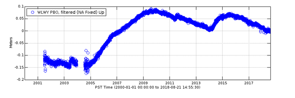
Vertical deformation at GPS station WLWY during 2001-2018
Data from continuous GPS stations indicate how the ground is moving over time. Station WLWY, near White Lake on the Sour Creek resurgent dome in Yellowstone caldera, has been operating since 2001. This plot shows vertical ground motion recorded at the site.
Data from continuous GPS stations indicate how the ground is moving over time. Station WLWY, near White Lake on the Sour Creek resurgent dome in Yellowstone caldera, has been operating since 2001. This plot shows vertical ground motion recorded at the site.
")
Collapse at Kīlauea (July 24, 2018)
A collapse event occurred at the summit of Kīlauea this morning (July 24, 2018) at 6:41 a.m. HST, releasing energy equivalent to a magnitude-5.3 earthquake, which is similar to that released by previous collapse events. In this video, watch as today's event unfolds from the perspective of HVO's live-stream camera.
A collapse event occurred at the summit of Kīlauea this morning (July 24, 2018) at 6:41 a.m. HST, releasing energy equivalent to a magnitude-5.3 earthquake, which is similar to that released by previous collapse events. In this video, watch as today's event unfolds from the perspective of HVO's live-stream camera.

Common Murre flying in lower Cook Inlet, Alaska
Common Murre flying in lower Cook Inlet, Alaska.
Common Murre flying in lower Cook Inlet, Alaska.