Wabash River at New Harmony IN - view from right bank
All Multimedia
Access all multimedia to include images, video, audio, webcams, before-after imagery, and more. Filter and explore with filtering options to refine search.

Wabash River at New Harmony IN - view from right bank

Wabash River at New Harmony IN - view of boat ramp
Wabash River at New Harmony IN - view of boat ramp
Wabash River at New Harmony IN - view of bridge
Wabash River at New Harmony IN - view of bridge

Wabash River at New Harmony, IN - high water view of museum
Wabash River at New Harmony, IN - high water view of museum

Wabash River at New Harmony, IN - town and bridge signs
Wabash River at New Harmony, IN - town and bridge signs

Wabash River at New Harmony, IN - view of bridge from boat
Wabash River at New Harmony, IN - view of bridge from boat

Wabash River at New Harmony, IN - view of gage from boat
Wabash River at New Harmony, IN - view of gage from boat

Red circles represent all seismicity and blue circles represent earthquakes as part of earthquake swarms. The size of the circles is scaled to the magnitude of the earthquake. The 630,000 year old Yellowstone caldera is shown as a bold black line within Yellowstone National Park. Mapped faults are shown as light gray lines.
Red circles represent all seismicity and blue circles represent earthquakes as part of earthquake swarms. The size of the circles is scaled to the magnitude of the earthquake. The 630,000 year old Yellowstone caldera is shown as a bold black line within Yellowstone National Park. Mapped faults are shown as light gray lines.
 Landsat in Action - Free & Open Landsat Archive with Barbara Ryan
Barbara Ryan, Director of GEO talks about the distribution of Landsat data, starting in 1972, and ultimately transitioning to the free and open policy of today.
Barbara Ryan, Director of GEO talks about the distribution of Landsat data, starting in 1972, and ultimately transitioning to the free and open policy of today.
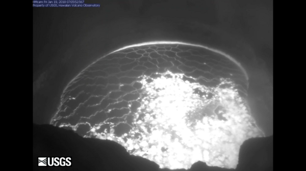
 Rockfalls trigger explosions in Kīlauea Volcano's summit lava lake
This video shows a rockfall and subsequent explosion that occurred at 7:03 a.m. HST today within the "Overlook crater" at the summit of Kīlauea. This collapse was followed by a smaller rockfall at 7:07 a.m. (not shown in video).
This video shows a rockfall and subsequent explosion that occurred at 7:03 a.m. HST today within the "Overlook crater" at the summit of Kīlauea. This collapse was followed by a smaller rockfall at 7:07 a.m. (not shown in video).

This video shows a rockfall and subsequent explosion that occurred at 7:03 a.m. HST today within the "Overlook crater" at the summit of Kīlauea. This collapse was followed by a smaller rockfall at 7:07 a.m. (not shown in video).
This video shows a rockfall and subsequent explosion that occurred at 7:03 a.m. HST today within the "Overlook crater" at the summit of Kīlauea. This collapse was followed by a smaller rockfall at 7:07 a.m. (not shown in video).

East Fork Whitewater River at Richmond IN - ice covered equipment
East Fork Whitewater River at Richmond IN - ice covered equipment

East Fork Whitewater River at Richmond IN - ice on the water
East Fork Whitewater River at Richmond IN - ice on the water

East Fork Whitewater River at Richmond IN - ice-covered stream
East Fork Whitewater River at Richmond IN - ice-covered stream

East Fork Whitewater River at Richmond IN -downstream ice-covered stream
East Fork Whitewater River at Richmond IN -downstream ice-covered stream

Geneticist, Kylle Roy, extracts DNA from samples to detect Ceratocystis, a fungal pathogen that causes Rapid Ohia Death. Samples have been acquired using aerial spore traps, by collecting wood shavings from ohia trees, or by collecting frass (excrement) of wood-boring beetles.
Geneticist, Kylle Roy, extracts DNA from samples to detect Ceratocystis, a fungal pathogen that causes Rapid Ohia Death. Samples have been acquired using aerial spore traps, by collecting wood shavings from ohia trees, or by collecting frass (excrement) of wood-boring beetles.
This picture was taken January 16 by Hydro Tech Tim Nicholson as he was assessing site conditions for a discharge measurement, which he determined was unsafe to make. 04191500 Auglaize River near Defiance
This picture was taken January 16 by Hydro Tech Tim Nicholson as he was assessing site conditions for a discharge measurement, which he determined was unsafe to make. 04191500 Auglaize River near Defiance
Antarctica's Pine Island Glacier has calved another iceberg. These Landsat images show the progression since just before the break in September until now.
At the USGS EROS Center, we study land change, operate the Landsat satellites, and maintain the longest, continuously acquired collection of images of the Earth's land surface.

Measuring streamflow through augered holes, North Platte nr Northgate
Measuring streamflow through augered holes, North Platte nr Northgate
Measuring streamflow, Fontenelle Creek
Measuring streamflow, Fontenelle Creek

East Fork Whitewater River at Richmond IN - bridge view
East Fork Whitewater River at Richmond IN - bridge view


