
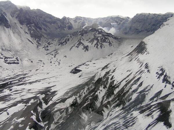
Aerial view, Mount St. Helens' crater and dome, as seen from the north.
Images
Explore our planet through photography and imagery, including climate change and water all the way back to the 1800s when the USGS was surveying the country by horse and buggy.
Filter Total Items: 21463

Aerial view, Mount St. Helens' crater and dome, as seen from the north
Aerial view, Mount St. Helens' crater and dome, as seen from the north.

Ash collecting, Plains of Abraham, eastern flank of Mount St. Helens
Ash collecting, Plains of Abraham, on the eastern flank of Mount St. Helens.
Ash collecting, Plains of Abraham, on the eastern flank of Mount St. Helens.

East side of Mount St. Helens' crater, glacier, and dome
East side of Mount St. Helens' crater and dome, as seen from the north.
East side of Mount St. Helens' crater and dome, as seen from the north.
Mount St. Helens' crater and dome, as seen from NW. Ash covering is...
Mount St. Helens' crater and dome, as seen from the northwest. Ash covering is from event of January 16, 2005.
Mount St. Helens' crater and dome, as seen from the northwest. Ash covering is from event of January 16, 2005.

Crater glacier and lava dome within Mount St. Helens' crater
Crater glacier and lava dome within Mount St. Helens' crater, east side view.
Crater glacier and lava dome within Mount St. Helens' crater, east side view.

Dome within Mount St. Helens' crater, Jan 2005, aerial view from NE.
Dome within Mount St. Helens' crater, January 2005, aerial view from the northeast.
Dome within Mount St. Helens' crater, January 2005, aerial view from the northeast.

Dome within Mount St. Helens' crater. Jan 2006
Dome within Mount St. Helens' crater. January 2006
Dome within Mount St. Helens' crater. January 2006

Kalmunai, Sri Lanka, after the December 2004 tsunami
Photo taken about 100 meters inland at Kalmunai on Sri Lanka's east coast.
Photo taken about 100 meters inland at Kalmunai on Sri Lanka's east coast.

Monitoring equipment installation on Mount St. Helens' dome. Camera...
Monitoring equipment installation on Mount St. Helens' dome. Camera/gas sampling station is to the right underneath helicopter. GPS/accelerometer (seismometer) spider is just visible as a speck on top of new dome.
Monitoring equipment installation on Mount St. Helens' dome. Camera/gas sampling station is to the right underneath helicopter. GPS/accelerometer (seismometer) spider is just visible as a speck on top of new dome.

Mount St. Helens' crater and new dome, from the east.
Mount St. Helens' crater and new dome, from the east.
Mount St. Helens' crater and new dome, from the east.

Mount St. Helens' crater and new dome, from the south.
Mount St. Helens' crater and new dome, from the south.
Mount St. Helens' crater and new dome, from the south.

Mount St. Helens' crater and new dome, from the west. Gash on top o...
Mount St. Helens' crater and new dome, from the west. Gash on top of dome is from the night of January 13, 2005.
Mount St. Helens' crater and new dome, from the west. Gash on top of dome is from the night of January 13, 2005.

Tilt-leg spider on top of north-face of the new dome. This station ...
Tilt-leg spider on top of north-face of the new dome. This station houses GPS and an accelerometer.
Tilt-leg spider on top of north-face of the new dome. This station houses GPS and an accelerometer.

After Tsunami Destruction
Sand and bricks deposited by the tsunami in an area of destruction on the East Coast of Sri Lanka at Kulmunai Kuddi.
Sand and bricks deposited by the tsunami in an area of destruction on the East Coast of Sri Lanka at Kulmunai Kuddi.

After Tsunami Destruction
Sand and bricks deposited by the tsunami in an area of destruction on the East Coast of Sri Lanka at Kulmunai Kuddi.
Sand and bricks deposited by the tsunami in an area of destruction on the East Coast of Sri Lanka at Kulmunai Kuddi.

Measuring Tsunami Height
Dr. Starin Fernanda, Geological Survey & Mines Bureau of Sri Lanka, taking measurement of height of tsunami, indicated by gouge mark in tree from debris carried by the tsunami.
Dr. Starin Fernanda, Geological Survey & Mines Bureau of Sri Lanka, taking measurement of height of tsunami, indicated by gouge mark in tree from debris carried by the tsunami.

Sampling Tsunami Deposits
Dr. Starin Fernanda, Geological Survey & Mines Bureau of Sri Lanka, preparing a trench for sampling of tsunami deposit. Leaves on the surface days or weeks after the tsunami and blanket the sand deposited by the tsunami.
Dr. Starin Fernanda, Geological Survey & Mines Bureau of Sri Lanka, preparing a trench for sampling of tsunami deposit. Leaves on the surface days or weeks after the tsunami and blanket the sand deposited by the tsunami.

Tsunami sand deposit
Tsunami sand deposit at Nilaveli Beach on the northeastern coast of Sri Lanka following the December 26th, 2004 earthquake and tsunami in the Indian Ocean. The sand deposited by the tsunami is light colored and overlies a pre-tsunami darker sandy soil.
Tsunami sand deposit at Nilaveli Beach on the northeastern coast of Sri Lanka following the December 26th, 2004 earthquake and tsunami in the Indian Ocean. The sand deposited by the tsunami is light colored and overlies a pre-tsunami darker sandy soil.

2005 Landslide in La Conchita, CA
On January 10, 2005, a landslide struck the community of La Conchita in Ventura County, California, destroying or seriously damaging 36 houses and killing 10 people. For a USGS rerpot on this event, please see USGS Open-file report, "Landslide Hazards at La Conchita, California."
On January 10, 2005, a landslide struck the community of La Conchita in Ventura County, California, destroying or seriously damaging 36 houses and killing 10 people. For a USGS rerpot on this event, please see USGS Open-file report, "Landslide Hazards at La Conchita, California."