Forecast, monitor, adapt: A multi-agency strategy to protect people from postfire debris flows
Landsliding follows signatures of wildfire history and vegetative regrowth in a steep coastal shrubland
Dynamic feedbacks between river meandering and landsliding in northwestern Washington glacial terraces
Constraining landslide frequency across the United States to inform county-level risk reduction
Landslide Hazards Program
The primary objective of the National Landslide Hazards Program is to reduce long-term losses from landslide hazards by improving our understanding of the causes of ground failure and suggesting mitigation strategies.
Landslide Basics
Landslide Basics

What is a landslide? Where do they happen and what causes them? Learn all about the basics of landslides here.
U.S. and Puerto Rico Landslide Hazard Map
U.S. and Puerto Rico Landslide Hazard Map

New high-resolution map of landslide susceptibility for the entire U.S. and Puerto Rico.
Quick Links
Quick Links
Here is where to find some of our most popular content:
News
Hurricane Helene’s Deadly Landslide Legacy
Hurricane Helene’s Deadly Landslide Legacy
USGS Awards a Dozen Landslide Risk Reduction Grants to Enhance Public Safety and Hazard Preparedness Nationwide
USGS Awards a Dozen Landslide Risk Reduction Grants to Enhance Public Safety and Hazard Preparedness Nationwide
USGS Seeks Landslide Risk Reduction Proposals (FY25)
USGS Seeks Landslide Risk Reduction Proposals (FY25)
Publications
Landsliding follows signatures of wildfire history and vegetative regrowth in a steep coastal shrubland Landsliding follows signatures of wildfire history and vegetative regrowth in a steep coastal shrubland
Five years after the deadly and destructive 9 January 2018 Montecito debris flows (Santa Barbara County, California, USA), an atmospheric river storm on 9 January 2023 triggered widespread landsliding that affected many of the same drainages in the Santa Ynez Mountains. Using high-resolution aerial imagery, we identified >10,000 landslides over an ∼160 km2 area. Most of the landslides...
Dynamic feedbacks between river meandering and landsliding in northwestern Washington glacial terraces Dynamic feedbacks between river meandering and landsliding in northwestern Washington glacial terraces
Landsliding in river valleys poses unique risks for cascading hazards and can damage infrastructure and cause fatalities. In postglacial valleys, many landslides are posited to occur in relation to lateral river erosion, but the dynamics of fluvial-hillslope interactions are not well understood. Here, we investigate a section of the Nooksack River in western Washington State where the...
Forecast, monitor, adapt: A multi-agency strategy to protect people from postfire debris flows Forecast, monitor, adapt: A multi-agency strategy to protect people from postfire debris flows
In 2020, a wildfire burned across Glenwood Canyon in Colorado, USA. A history of postfire debris flows in the region and a hazard assessment for the burn area indicated that potentially life-threatening debris flows could be triggered by rainfall within months of a wildfire. As a result, four government agencies evaluated strategies to help mitigate hazards, including the loss of human...
Science

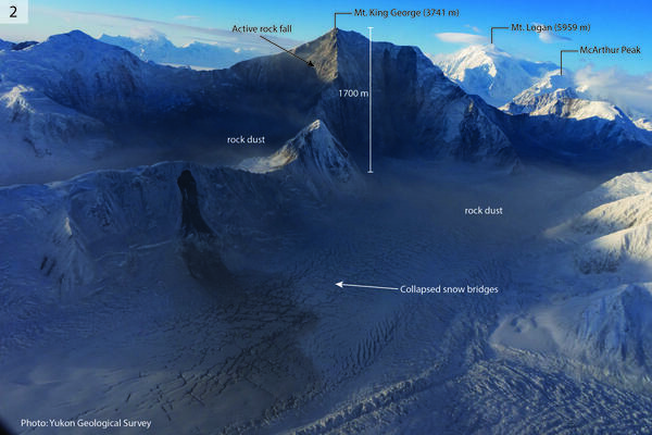
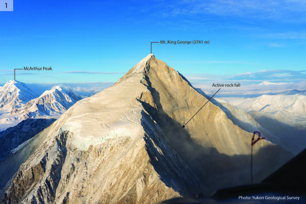
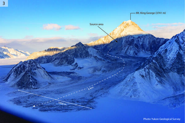
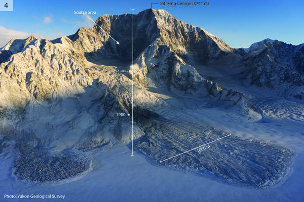
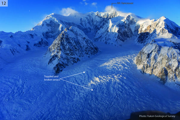
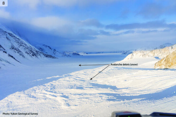
2025 M7.0 Hubbard Glacier Earthquake-Triggered Landslides and Snow Avalanches
A M7.0 oblique-slip earthquake initiated about 10 km below the Hubbard Glacier in the St. Elias Mountains about 88 km north of Yakutat, Alaska, at approximately 11:40am AKST (1:40pm YST) on December 6, 2025. The U.S. Geological Survey (USGS) Ground Failure product estimated that landslides triggered by this earthquake would likely be significant in number and/or spatial extent. This was confirmed...
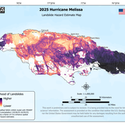
2025 Hurricane Melissa Landslide Hazards
Hurricane Melissa, a category 5 storm, made landfall on October 28, 2025, near the border of Westmoreland and St. Elizabeth Parishes, southwestern Jamaica. The storm brought heavy rainfall, strong winds, and flooding to much of the Caribbean. In Jamaica, intense rainfall on steep mountainous terrain raised concern about potential landslides. This landslide event page serves as an event summary to...
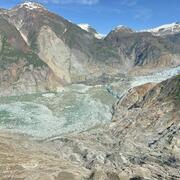
2025 Tracy Arm Landslide-Generated Tsunami
A landslide above the toe of the South Sawyer Glacier failed into the waters of Tracy Arm, south of Juneau, Alaska, producing a tsunami on Sunday, August 10th, 2025, at 05:26 AKDT / 13:26 UTC. No injuries or fatalities have been reported. This page may be updated as more information about the event is obtained. Steep, mountainous landslide areas are inherently unstable and will continue to change...